Browse Listings in America
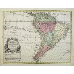
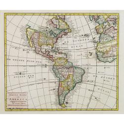
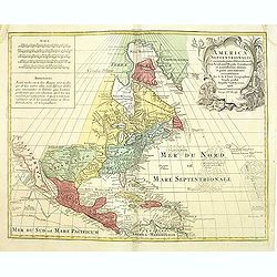
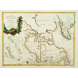
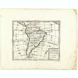
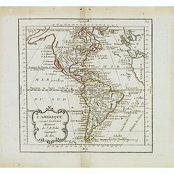
America Meridionalis.
This is the more scarce edition with the title cartouche lower left surrounded by Neptune and a native Indian.A rather accurate depiction and descriptions of South Americ...
- $550 / ≈ €476
Date: Augsburg, c. 1760
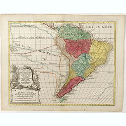
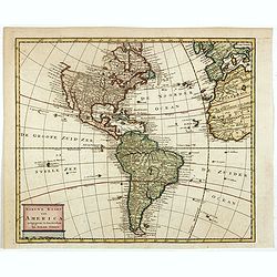
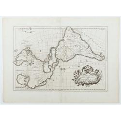
America Meridionalis.
The title cartouche lower left surrounded by native Indians and an Elephant.A rather accurate depiction and descriptions of South America. Brazil is slightly enlarged and...
Date: Augsburg, c. 1760

Nader prolongatie van het Octroy voor de Westindische Compagnie voor den tyd van nog dertig jaaren. . .
A proclamation by the Dutch States General, dated 1761, extending the charter of the Dutch West India Company for another thirty years. Like the 1730 proclamation, it has...
Date: Amsterdam, 1761
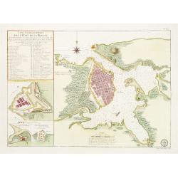
Carte Hydrographique de la Baye de la Havane.. N° 69.
A well-engraved and highly detailed chart of the walled city of Havana and its harbor features inset plans of three forts (La Punta, El Morro, and La Real Fuerza) as well...
Date: Paris, 1762
Carte de la Guyane Françoise et l'Isle de Cayenne..
A well engraved and highly detailed chart of French Guiana and the island of Cayenne. Made in 1763 by Jacques Bellin (1703-72), a prolific cartographer assigned the Minis...
Date: Paris, 1763

Nieuwe gemeten kaart van de colonie de Berbice met der zelver plantagiën en de namen der Bezitters. . .
Re-issue of his map from 1740, without the printed list of owners, with a large added contemp. hand-colored cartouche Relaas van de rebellie, ontstaan op de plantagien in...
Date: Amsterdam, ca.1763

Plan du Port de St Augustin dans la Floride.
This chart shows a plan of the Port of St. Augustine in Florida.The only issue of this version of Bellin's map, slightly larger than the common version. Depths shown by s...
Date: Paris, 1764
Nieuwe kaart van America.
An attractive map of both the Americas, by one of the leading mapmakers in 18th century Amsterdam. Isaak Tirion (d. 1769) was a Amsterdam publisher. His "Nieuwe en b...
- $400 / ≈ €346
Date: Amsterdam, 1765
Nieuwe kaart van America.
An attractive map of both the Americas, by one of the leading mapmakers in 18th century Amsterdam. Isaak Tirion (d. 1769) was a Amsterdam publisher. His "Nieuwe en b...
Date: Amsterdam, 1765
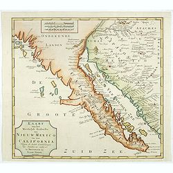
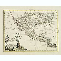
Kaart van het Westelyk Gedeelte van Nieuw Mexico en van California. . . MDCCLXV ..
A detailed map of the Baja California and Sonora, bounded on the north by the Colorado and Gila Rivers and approximately Mozatlan in the south, thus including parts of mo...
Date: Amsterdam, 1765

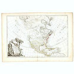
America settentrionale. . .
Rare map of North America drawn directly from the work of Nicholas De Fer and N. Sanson's famous map of 1650. The map is engraved by Antonius Donzel Gallus.With open Grea...
Date: Napels, 1766

Carte Réduite De La Partie Septentrionale De L'' Isle De Terre Neuve..
A well engraved and highly detailed chart, corrected to 1767. Elaborate hand-colored cartouche, rhumb lines.Shows northern part of Newfoundland and southern coast of Labr...
Date: Paris, 1767

The Harbour of Casco Bay and Islands Adjacent Bt Capt. Cyprian Southicke.
The earliest printed chart of Casco Bay, an inlet of the Gulf of Maine on the southern coast of Maine, New England. First issued in 1720 by Mount and Page, it remained in...
Date: Dublin, 1767
Partie De L'Amerique Septentrionale... Le Cours De L'Ohio, La N.lle Angleterre, a Nlle York, le New Jersey , La Pensyvanie, Le Maryland, Le Virginie, La Carolina...1755
From the Atlas Universel , a detailed map extending the length of the east coast from Penobscot Bay to Cape Fear and, in an inset, from Cape Fear to Fort St.Georges.This ...
- $800 / ≈ €692
Date: Paris, 1768

Nieuwe Kaart van de Grootbrittannische Volkplantingen in Noord America waar in Tevens de Fransche Bezittingen en de Landen tuschen die Beide Volken. . .
A map of the east-coast of America from New Foundland till Florida, divided in French and British properties. Reduced size Dutch edition of Mitchell's map of North Americ...
Date: Amsterdam, 1769

Nieuwe kaart van Kanada . . .
Nice map of the Bay of Hudson, In Labrador, a small inset of Nova Scotia. The map is dated 1769. All text is in Dutch. The map shows the region shortly after the conclusi...
Date: Amsterdam, 1769

Plan der Stadt Quebec Haupstadt in Neu Franckreich oder Canada.
Town-plan of Quebec, with an inset view of the town in the lower right corner. In the upper right a recapitulation of the main military actions prior to the surrender of ...
Date: Nurnberg, 1770
America Septentrionalis, Concinnata juxta Observationes..
This exemplar represents Lotter's version of Delisle's foundation map of North America, published in 1700. The Great Lakes show the French strong holds at Quebec, Montrea...
- $875 / ≈ €757
Date: Augsburg, ca. 1770
America Septentrionalis et Meridionalis. T. XXXV.
Uncommon map in the style of Coronelli of the Western hemisphere. Map of America depicted as an elongated figure, oriented with North to West.This map is most notable for...
Date: Italy c. 1770

Carte des parties Nord et est de l'Asie.. (5 maps on one sheet)
Five maps on one sheet, showing California, Alaska and Syberia, Korea and Japan. South to Korea the island "Quelpaerts".The map is from Diderot's "Encyclop...
- $200 / ≈ €173
Date: Paris, 1772
Carte des parties nord et ouest de L' Amerique. . .
An interesting map of North America, based upon an earlier map by Thomas Engel. His map of North America was issued in his 'Memoires Observations Geographique' in 1765, a...
Date: Paris, 1772
Carte de la Californie et des Pays Nord-Ouest..
From Diderot's Encyclopedia. Fascinating study of the comparative cartography of the West Coast of North America, from the Straits of Anian to Cabo San Lucas and the sout...
Date: Paris, 1772
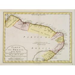
Carte du Bresil Prem.Partie...
Uncommon edition of this accurate map of the eastern part of Brazil.From Atlas Portatif pour servir a l'intelligence de l'Histoire Philosophique et Politique des etabliss...
- $100 / ≈ €87
Date: Amsterdam, 1773
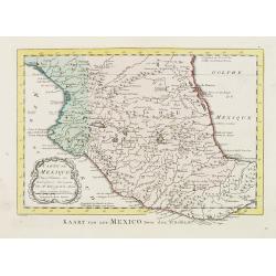
Carte du Mexique.
Uncommon edition of this fine map of Mexico. In lower right engraved 24.From Atlas Portatif pour servir a l'intelligence de l'Histoire Philosophique et Politique des etab...
- $75 / ≈ €65
Date: Amsterdam, 1773
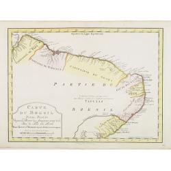
Carte du Bresil Prem. Partie..
Uncommon edition of this accurate map of eastern part of Brazil. In lower right engraved 29a.From Atlas Portatif pour servir a l''''intelligence de l''''Histoire Philosop...
Date: Amsterdam, 1773
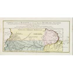
Carte du Cours du Maragnon ou .. Amazones..
Uncommon edition of this map of the river Amazon. In lower right engraved "30."From Atlas Portatif pour servir a l'intelligence de l'Histoire Philosophique et P...
Date: Amsterdam, 1773
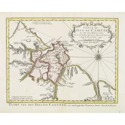
Carte de L'Isle de Caiene et de ses environs.
Uncommon edition of this accurate map of Cayenne. In lower right engraved "31."From Atlas Portatif pour servir a l'intelligence de l'Histoire Philosophique et P...
Date: Amsterdam, 1773
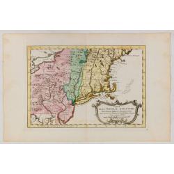
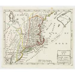
Carte de la Nouvelle Angleterre, Nouvelle York et Pensilvanie / Pour servir à l'Histoire Générale des Voyages.
Uncommon edition of this accurate map the east coast from Delaware River till Main.Left hand corner Lake Ontario. In lower right engraved "38."From Atlas Portat...
- $275 / ≈ €238
Date: Amsterdam, 1773
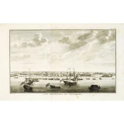
Vue de la Rade et de la Ville de Paramaribo.
A very decorative panoramic view of the town with a large Dutch vessel in the foreground. Engraved by Noach van der Meer Junior. Included in a Dutch edition of "Hist...
Date: Amsterdam, 1774
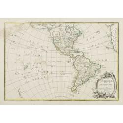
Carte D'Amerique divisée en ses principaux Pays Dressée sur les Mémoires les plus recents, et sur differents Voyages et assujettie aux Observations Astronomiques de Mrs. de l'Academie Royal des Sciences Par Mr. l'Abbe Clouet . . . 1774.
The rare 1774 edition of this fine map of the western hemisphere published by Clouet in Rouen. A later edition with the date 1787 also exists. With inset map "Carte ...
Date: Paris, 1774
![[Haida Gwaii,] Baye Swallow . . . / Havre Byron /Côté septentrional de la plus grande des Isles de la Reine Charlotte. . . .](/uploads/cache/25888-250x250.jpg)
[Haida Gwaii,] Baye Swallow . . . / Havre Byron /Côté septentrional de la plus grande des Isles de la Reine Charlotte. . . .
Map of Swallow's Bay and a coastline profile of the Queen Charlotte Islands and Captain Byron's Heaven.Queen Charlotte Islands, with their modern name Haida Gwaii, is an ...
Date: Paris, 1774
![Prospect des Plazes vor dem Rath Haus zu Boston. Vuë de la Rue et de la Maison de Ville a Boston. [together with] Prospect der König[lichen] ...](/uploads/cache/34214-250x250.jpg)
Prospect des Plazes vor dem Rath Haus zu Boston. Vuë de la Rue et de la Maison de Ville a Boston. [together with] Prospect der König[lichen] ...
Two so-called optical prints show a decorative imaginary view of the old state house, built in 1657, which was the center of government for the colony of Massachusetts an...
- $1500 / ≈ €1298
Date: Augsburg, ca. 1776
![[Upper sheet map only] The Provinces New York, and New Jersey with part of Pensilvania and the Province of Quebec.](/uploads/cache/25624-250x250.jpg)
[Upper sheet map only] The Provinces New York, and New Jersey with part of Pensilvania and the Province of Quebec.
Rare separately issued map, unfortunately only the upper part of the map. It is a variant of this important colonial map. The upper sheet showing the upper course of the ...
- $750 / ≈ €649
Date: Frankfurt, 1777

A Map of the most Inhabited part of New England containing the Provinces of Massachusetts Bay and New Hampshire, with the Colonies of Connecticut and Rhode Island.
A copper engraving in four sheets, published in Georges Louis Le Rouge, in his "Atlas Ameriqua in Septentrional Contenant les details des differentes provinces, de c...
Date: Paris, 1777

Carte nouvelle de l'Amérique angloise contenant tout ce que les Anglois possèdent. . . avec la Floride / gravée. . . par Maththias Albert Lotter. . .
As mentioned in the title piece, the map includes the area at that time in the possession of the English, i.e. Canada, New Large, beautiful and detailed map of the Easter...
Date: Augsburg, 1777
![[Lower half] Amerique Septentrionale avec les Routes, Distances en miles, Limites et Etablissements François et Anglois Par le Docteur Mitchel Traduit de 'Anglois..](/uploads/cache/49378-250x250.jpg)
[Lower half] Amerique Septentrionale avec les Routes, Distances en miles, Limites et Etablissements François et Anglois Par le Docteur Mitchel Traduit de 'Anglois..
This is the important 1777 Georges Le Rouge French edition of the seminal John Mitchell map of the eastern part of North America. The Mitchell map is considered the singl...
Date: Paris, 1777

Ilse Paese de' Selvaggi.. Lago Superiore. (Florida and the Bahamas)
Antonio Zatta published an Italian version of the John Mitchell map in twelve sheet. This sheet depicts Lake Superior in the Bellin version, as it appeared on the Mitchel...
Date: Venice, 1778
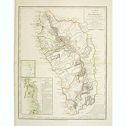
Carte de la Dominique Prise par les Francois le 7 Septembre 1778. Avec le Plan du Debarquement et de l'Attaque des Forts et Batteries par les Troupes et Les Fregates de sa Majeste
A rare map of St. Dominica, with insets of Charlotteville with its attack by the French on 7 September 1778 on the British. Also small inset map of the Caribbean islands ...
- $500 / ≈ €433
Date: Paris, 1778
Parte Orientale della Florida, della Giorgia, e Carolina. . .
Attractive map covering the coast from S.Augustine till Long Bay, including Jacksonville, Savannah. From Zatta's Atlante Novissimo.
- $350 / ≈ €303
Date: Venice, 1778

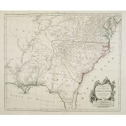
Carte Réduite Des Côtes Orientales De L' Amérique Septentrionale Contenant Partie du Nouveau Jersey.. Virginie.. Georgie..
Uncommon chart that extends from Delaware Bay and Philadelphia south through much of Georgia to Island Amelia and St. Johns River. Fleur-de-lis and rhumb lines fill the s...
Date: Paris, 1778
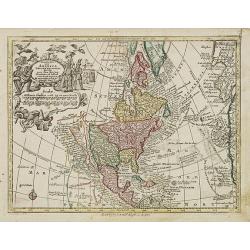
Nov' Orbis Sive America Septentrionalis. . .
Miniature map of North America, a reduction of the appropriate part of Seutter's folio map of the Americas, drawn by Albert Seutter. An unusual looking map, its projectio...
Date: Augsburg, J.M.Will, 1778
Carte des troubles De L'Amerique Levée par Ordre du Chevalier Tryon. . . New-York.. Jersey..
Revolutionary War mapA French edition of this uncommon Revolutionary War map describes the region from Salem, Massachusetts, to Buzzard's Bay, south to the Delaware River...
- $1500 / ≈ €1298
Date: Paris, 1778
La Baja D'Hudson Terra di Labrador e Groenlandia.
Decorative map of Nova Scotia, Hudson Bay and part of Greenland. With many names of villages, as well engraved mountains and rivers are shown.Published in Zatta's "A...
- $300 / ≈ €260
Date: Venice, 1778

Mappa Geographica provinciae Nova Ebboraci ab Anglis NEW-YORK dictae. . .
During the Revolution, this map afforded British commanders an excellent overview of areas that would be crucial in the early years of the war, particularly the Hudson Va...
Date: Nuremberg, 1778

Vue de la Rue du Roi, vers la Porte de la Campagne a Boston.
A vue d'optique of the city of Boston. A view of a typical Bostonian street, with buildings opening directly onto the throughway, groups of people, gentlemen, workers and...
Date: Augsburg, 1778
Mappa Geographica provinciae Nova.. NEW-YORK..
This map afforded British commanders during the Revolution an excellent overview of areas that would be crucial in the early years of the war, in particular the Hudson Va...
- $1500 / ≈ €1298
Date: Nuremburg, 1778

Mappa geographica Provinciæ Nova Eboraci ab Anglis New-York . . .
Lower part of the two sheets map of Homann Heirs' edition of Sauthier's celebrated map of New York and New Jersey, made during the Revolutionary War. Appears in Homann's ...
Date: Nuremburg, 1778
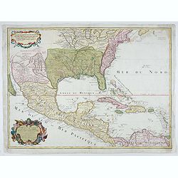
Carte du Mexique et de la Nouvelle Espagne..
Santini's version of D'Anville's important map shows the south-eastern part of the United States, Mexico and the Gulf of Mexico. Tecas is named as Nouv'le Leon. La Salle'...
Date: Venice 1779
Carte de la Californie et des Pays Nord-Ouest. . . 4de Carte.
Diderot's famous 2 on 1 map shows the two early mappings of the west coast of North America, the first after Visscher, the second after Plancius' World map. Both show the...
- $200 / ≈ €173
Date: Paris, 1779
L'Isle de la Dominique par M.J.M.Anglois. . .
A handsome map of the Caribbean island of Dominica. There are "Observations" at lower left, and "Suite des observations" at lower right, both providin...
Date: Paris, 1779

Carte d'une Partie des Cotes de la Floride et de la Louisiane, Contenant le Cours du Mississipi...
A well engraved and highly detailed chart of part of the Gulf Coast, dated 1778 that was issued in Neptune americo-septentrionale. The chart covers the area between St. J...
Date: Paris, 1778-1780
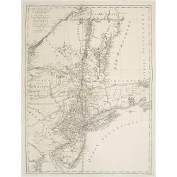
Carte de la Nouvelle Angleterre, Nouvelle York, Nouvelle Jersey, et Pensilvanie.
Highly detailed regional map of the Northeastern US, featuring numerous place names, Forts, Native American tribes, rivers,coastal banks, and other details. This is a Fre...
- $250 / ≈ €216
Date: Paris, 1780

Prospect der Strasse gegen der Kirche der Recolecten in der obern Stadt zu Quebec. Vuë de la Rue des Recolets dans la haute Ville de Quebec.
A so-called optical print showing a decorative imaginary town view of Québec, with a street view with soldiers marching and pedestrians, an idealized view depicting Qué...
- $450 / ≈ €389
Date: Augsburg, ca. 1780

Prospect des Haupt Plazes der Untern Stadt zu Quebec.
A so-called optical print showing a decorative imaginary town view of Québec, with a street view with soldiers marching and pedestrians, an idealized view depicting Qué...
- $500 / ≈ €433
Date: Augsburg, ca.1780
L'America meridionale divisa nei suoi principali stati.
Rare map of south America, from "Atlante Novissimo ad uso Dei Giovani Studiosi Contenuto In Carte XXVII.", published by Giovanni Zempel in Rome, ca. 1780.The ma...
- $100 / ≈ €87
Date: Rome, 1780

Connecticut and Parts adjacent at Amsterdam. .
A nice example of this early map of the state of Connecticut with part of Rhode Island to the east, Long Island to the south, and New York to the east. Rivers, roads, t...
Date: Amsterdam, 1780
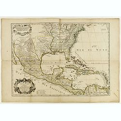
L'Ancien et le nouveau Mexique avec la Floride..
Covering Florida, Texas, western part of Cuba and central America. Showing dozens (100+) of place names, extensive river systems, mountain ranges and featuring the Gulf o...
Date: Paris, 1781
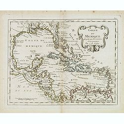
Golfe du Mexique Assujetti aux Observations Astronomiques Par J.B.Nolin.
Rare map of the Caribbean prepared by J.B.Nolin and published by L.J. Mondhare for his Atlas Général a l'usage des colleges et maisons d'education.. Louis Joseph Mondha...
- $200 / ≈ €173
Date: Paris, 1781
Carte du Bresil le Perou. . .
Scarce map of Northern part of South America with Venezuela, Colombia, Brazil and Peru, prepared by Nolin and published by L.J. Mondhare for his Atlas Général a l'usage...
- $125 / ≈ €108
Date: Paris, 1781
L'Amerique Septentrionale Divisee en Ses Principaux Etats. . .
Engraved by Lattré. This map is most notable for its depiction of Mer de L'Quest or Sea of the West, near modern-day Seattle. A great sea, easily the size of the Mediter...
- $400 / ≈ €346
Date: Paris, 1782

Carte Geo-Hydrographique du Golfe du Mexique et de ses Isles..
Map of the Caribbean and Gulf of Mexico showing the various islands and continental coastlines according to the 18th century Venetian cartography of Rizzi Zannoni.Illustr...
Date: Paris, ca 1783
L' Amerique divisée par Grands Etats. . .
Attractive map of America, ornated with a decorative title cartouche. Boundaries outlined in hand color.Prepared by Le Sieur Janvier, Jean denis [Robert], French geograph...
- $450 / ≈ €389
Date: Paris, ca 1783
L'Amérique suivant les dernier. . .
Scarce map of America, prepared by Nolin and published by L.J. Mondhare for his Atlas Général a l'usage des colleges et maisons d'education.. Louis Joseph Mondhare was ...
- $200 / ≈ €173
Date: Paris, 1783

Carte du Mexique et des Etats Unis d'Amérique...
A later edition of De l'Isle's foundation map of 1703, is widely regarded as one of the most influential maps in the history of American Cartography. This updated version...
Date: Paris, 1783
Carte du Mexique et des Etats Unis d'Amérique...
A later edition of De l'Isle's foundation map of 1703 is widely regarded as one of the most influential maps in the history of American Cartography. This updated version ...
Date: Paris, 1783
Carte du Mexique et des Etats Unis d'Amérique…
A later edition of De l'Isle's foundation map of 1703, widely regarded as one of the most influential maps in the history of American Cartography. This updated version o...
Date: Paris, 1783

Carte Générale du Canada, de la Louisiane, de la Floride, de la Caroline..
Map of the eastern part of the United States and Canada. With inset map of Hudson and Baffin bays. in the lower right corner.Venetian edition of d'Anville's map, from &qu...
Date: Venice, 1776 - 1784
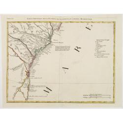
Partie Méridionale de la Louisiane, avec la Floride, la Caroline et la Virginie..
Fine map of southeastern part of the United States after d'Anville's, to whom Santini gives credit in the cartouche.It covers the Atlantic coastline between the Chesapeak...
Date: Venice, 1776 - 1784
Messico ouvero Nuova Spagna che contiene Il Nuova Messico La California con una Parte de Paesi Adjacenti. . .
Decorative and detailed map of Mexico, Texas, Florida, Louisiana, and Central America. The map is filled with remarkable detail throughout, particularly in Texas, New Mex...
Date: Venise, 1785

Carte D'Amerique Divisée en ses Principaux Pays. . .
Rare. Uncommon and decorative wall map of America, prepared by Clouet. With superb decorative borders, 170mm wide at the sides and 150mm at the bottom, containing twenty ...
Date: Paris, Cadiz, 1785

ETATS-UNIS DE L'AMÉRIQUE SEPTENTRIONALE Avec LES ISLES ROYALE, DE TERRE NEUVE, DE S.T JEAN, L'ACADIE, &c. 1785. Supplement a l'Atlas de M. Robert de Vaugondy a Paris Ches Boudet Ingenieur du Roi.
A map of the eastern United States with "Supplément à l'atlas de M. Robert de Vaugondy à Paris chez Boudet Imprimeur du Roi", in place of the attribution to ...
Date: Paris, 1785

Amérique Septentrionale .. Les Etats Unis..
Very rare state: probably separately issued. Published the same year as the Treaty of Paris, this is one of the first maps to show printed boundary lines for the newly...
- $3000 / ≈ €2596
Date: Paris, 1786
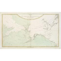
Karte von den N.W. Amerikanischen und N.OE. Asiatischen Kusten nach den Untersuchungen des Kapit. Cook...
A detailed large-scale map showing the Bering Strait, Kamchatka, Alaska and much of North America. While the Russian coastline is shown with reasonable accuracy. Showin...
- $450 / ≈ €389
Date: Vienna, 1788

L'Amérique divisée en ses principaux Etats Dressée d'après les Cartes de Mr. Bonne. . .
Rare, wall map of America in 2 sheets, after R. Bonne. With 3 inset maps of Hispaniola, Martinique and Hudson Bay. Beautiful title cartouche depicting a Native American l...
Date: Paris, 1788
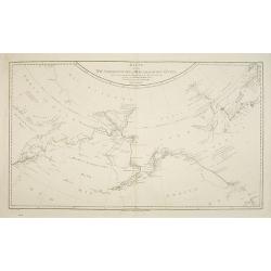
Karte von den N.W. Amerikanische und N.O.E. Asia. . .
German edition of Cook's explorations along the NW Coast of America and NE Coast of Asia, based upon the original work by Lieutenant Henry Roberts.A detailed large-scale ...
- $400 / ≈ €346
Date: Vienna, 1788
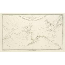
Karte von den N.W.Amerikanische und N.O.E. Asia..
A detailed large-scale map showing the Bering strait, Kamchatka, Alaska, and much of North America. While the Russian coastline is shown with reasonable accuracy. Showing...
Date: Vienna 1788

Map of Louisiana from D'Anville's Atlas.
This map presents a highly detailed treatment of the region from Cabo Del Norte to the Apalachiola River, centered on the mouth of the Mississippi and extending inland to...
Date: London, 1788
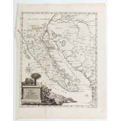
Carta Della California Suo Golfo E. Contracoste della Nueva Spagna.
Map featuring the California Peninsula and New Spain by Francisco Saverio Clavigero, engraved by J. Zambelly. Title cartouche within a landscape of cacti and palm trees.O...
Date: Venice, 1788
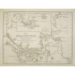
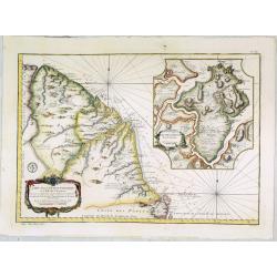
Karte der Magellanischen-Strasse. . .
Very detailed map of Strait of Magellan, with in top inset map of Southern tip of South America with the Falklands. Prepared by Don Juan de La Cruz of Spain.Engraved by J...
- $600 / ≈ €519
Date: Vienna, 1789
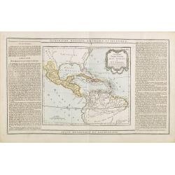
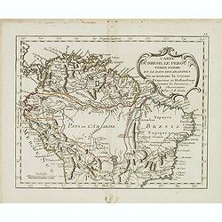
Guayane, Terre Ferme Isles Antilles. . .
Map showing Mexico, Cuba, Central America. Left and right a box with geographical information for each part country on the continent.Prepared by Louis Brion de la Tour an...
- $200 / ≈ €173
Date: Paris, 1790