Browse Listings in America
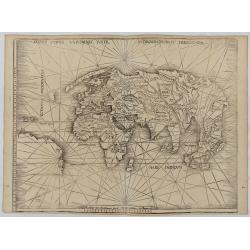
Orbis Typus Universalis Iuxta Hydrographorum Traditionem.
Waldseemüller's monumental modern map of the world from the celebrated Strassbourg edition of Ptolemy's Geography, the most important cartographer of the early sixteenth ...
Date: Strasburg, 1513 / 1520
![Claudii Ptolemaei Alexandrini mathematicor[um] ...Octo libri Geographie. . .](/uploads/cache/62656-250x250.jpg)
Claudii Ptolemaei Alexandrini mathematicor[um] ...Octo libri Geographie. . .
Third edition of "Géographie" by Ptolemy and published in Strasbourg. Illustrated with 50 maps engraved in wood. One of the more important maps shows the earlie...
Date: Strasbourg, J. Grüninger, 1522
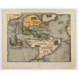
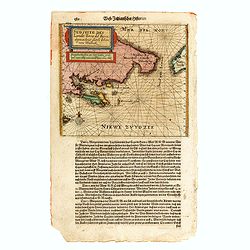
Die neüwen Inseln/ so hinder Hispanien gegen Orient bey dem land Indie ligen.
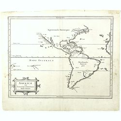
The earliest and one of the most important separate maps to show both Americas. Although it was not the first map to use “America” as a designation for the New World, it ...
Date: Basle 1561

Tierra Nueva.
Uncommon first edition of this early map of the east coast is an enlarged version of Giacomo Gastaldi map published in 1548. Nomenclature and cartography are unchanged, w...
Date: Venice, 1561

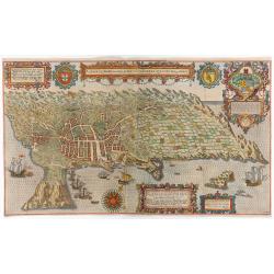
Il Cuscho citta principale della provincia del Peru.
A very desirable and scarce item of this decorative and early bird's-eye town-plan of the Inca city of Cuzco. Several figures shown inside the city walls and on the hills...
Date: Lyons, 1564
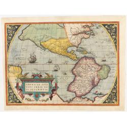
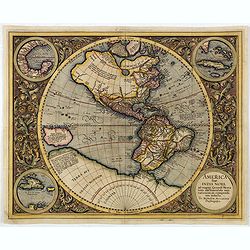
Americae Sive Novi Orbis, Nova Descriptio.
This is the second state of the first copperplate of Ortelius' map showing the western hemisphere, showing the prominent bulge in the South American coastline. The first,...
Date: Antwerp, 1573
Americae Sive Novi Orbis, Nova Descriptio
Woodcut map by based on Abraham Ortelius' classic map of 1570, with the huge bulge in the southwest coastline of South America, the Ortelian western coastline of North Am...
Date: Basel, ca. 1588

La Florida/ Peruviae Auriferae regionis Typus/ Guastecan.
The Chaves map of Florida is a prime example of an explorer's map since it records the recent discoveries of Cabeza de Vaca, De Soto, and Moscoso. The map revealed little...
Date: Antwerp, 1592

La Florida/ Peruviae Auriferae regionis Typus/ Guastecan.
The Chaves map of Florida is a prime example of an explorer's map since it records the recent discoveries of Cabeza de Vaca, De Soto, and Moscoso. The map revealed little...
Date: Antwerp, 1592

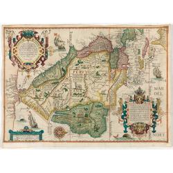
Americae Pars Magis Cognita. Chorographia nobilis & opulentae Peruanae Provinciae, atque Brasiliae, . . . MDXCII
First state. Although a map of South America it does include much of what is now the southern United States. There are two elaborate, strap-work cartouches with the one a...
Date: Frankfurt, 1592
(South America) - Delineatio omnium orarum totius Australis partis Americae, dictae Peruvianae, a R. de la Plata, Brasiliam Pariam, et Castellam auream una cum omnibus…
1593 LINSCHOTEN, J.H. van - Decorative map of South America, which goes as far north as part of Florida, is extremely well-detailed along the coast.
Date: Amsterdam, 1593

(Island of Pearls) Perlarum insula ob unionum copiam sic dicta.
A depiction of Cubagua as the Perlarum Insula (Island of Pearls), with in the foreground, two large ships send dinghies toward busy Native Americans collecting pearl oyst...
Date: Frankfurt, 1594
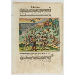
Cacodemon attacking the savages.
Cacodemon ("evil spirit") attacking the savages. Read more about "Les Grand Voyages" by Theodore De Bry [+]
Date: Frankfurt, 1594
![Arcis Carolinae delineatio [Jacksonville]](/uploads/cache/48530-250x250.jpg)
Arcis Carolinae delineatio [Jacksonville]
Depicting Fort Caroline in Jacksonville, Florida. A French expedition, organized by Protestant leader Admiral Gaspard de Coligny and led by the French Explorer Jean Ribau...
Date: Frankfurt, 1594
![[The French left in Fort Charles suffer the scarcity of provisions. (Virginia]](/uploads/cache/48529-250x250.jpg)
[The French left in Fort Charles suffer the scarcity of provisions. (Virginia]
An Indian town visited by the French of Charlesfort in search for food. After a drawing by LeMoyne. Charlesfort-Santa Elena is on what is now Parris Island, South Carolin...
Date: Frankfurt, 1594
![Pisces in mari alati [flying fish attack]](/uploads/cache/48527-250x250.jpg)
Pisces in mari alati [flying fish attack]
Flying fish attacking a Portuguese ship in the West Indian Waters.Read more about "Les Grand Voyages" by Theodore De Bry [+]
Date: Frankfurt, 1594
![[Navel battle between Portuguese and French Battle off Buttugar (Brazil).]](/uploads/cache/48526-250x250.jpg)
[Navel battle between Portuguese and French Battle off Buttugar (Brazil).]
Navel battle between Portuguese and French in the seas off the Poti guaran Territories in Brazil.Read more about "Les Grand Voyages" by Theodore De Bry [+]
Date: Frankfurt, 1594
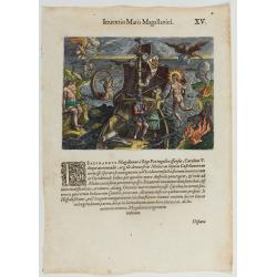
Inventio Maris Magallanici.
Allegorical scene, allegorical image celebrating the circumnavigation of the earth by Ferdinand Magellan. The image shows Magellan aboard his ship, surrounded by mytholog...
- $750 / ≈ €659
Date: Frankfurt, 1594
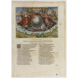
Americae Retectio (Allegory of the Discovery of America)
Allegorical scene commemorating the discovery of America. The main image shows Neptune, supporting a Globe, flanked by Flora-representing Florence, and Janus-representin...
Date: Frankfurt, 1594
Hispaniae novae sive magnae recens et vera descriptio. 1579
This was the standard map of the area for a generation, copied by De Bry, Quad and Hondius. Even though Herrera (Spain's Royal Cosmographer) and Wytfliet worked 20 years ...
Date: Antwerp, 1598
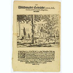
Plants Lantor, Assa, Pimenta, Mangostan and Pepper.
Lantor is a kind of coconut palm (or Indian nut) with fronds as long as a human body. These fronds are used as paper. Pimenta del Rabo (or cubebe) grows grape-like on tre...
- $80 / ≈ €70
Date: Frankfurt, 1598
A cidade de Angra na ilha de Iesuxpo da Tercera..
Spectacular perspective view of the harbour and town of Angra on the island of Terceira in the Azores. It was at the time an important port and administrative centre of t...
Date: Amsterdam, 1598
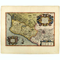
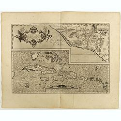
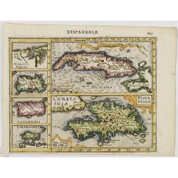
Culiacanae Americae regionis.. / Hispaniolae, Cubae..
Two separate virtually identically sized inset maps on one sheet, each with a decorative scroll title cartouche. Culiacanae depicts the coastal and inland western region ...
Date: Antwerp 1598
Culiacanae Americae regionis.. / Hispaniolae, Cubae..
Two virtually identically sized inset maps on one sheet, each with a decorative scroll title cartouche. Culiacanae depicts the coastal and inland western region in North ...
Date: Antwerp, 1598
La Florida/ Peruviae Auriferae regionis Typus/ Guastecan.
The Chaves map of Florida is a prime example of an explorer's map since it records the recent discoveries of Cabeza de Vaca, De Soto, and Moscoso. The map revealed little...
Date: Antwerp, 1598
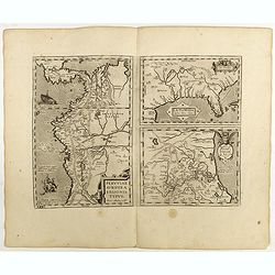
![Peruviae Auriferae Regionis Typus [with] La Florida Auctore Hieron Chiaves [with] Guastecan Reg.](/uploads/cache/60004-250x250.jpg)
Peruviae Auriferae Regionis Typus [with] La Florida Auctore Hieron Chiaves [with] Guastecan Reg.
The Chaves map of Florida is a prime example of an explorer's map since it records the recent discoveries of Cabeza de Vaca, De Soto, and Moscoso. The map revealed little...
- $2000 / ≈ €1758
Date: Antwerp, 1598
![Ambivi.. Victoria.. [The ship victoria of Magellan]](/uploads/cache/49479-250x250.jpg)
Ambivi.. Victoria.. [The ship victoria of Magellan]
A rare print representing the ship Victoria by Ferdinand Magellan ( c. 1480 – 27 April 1521), crossing the Pacific Ocean. First published in 1598 in his Caert-Thresoor, ...
Date: Amsterdam, 1606
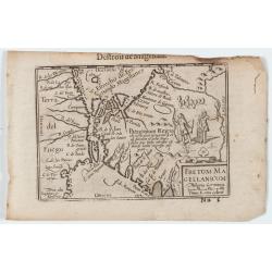
Fretum Magellanicum / Detroit de Magellan.
Early nice map of the South American extremity with the Strait of Magallanes, discovered by Ferdinand Magellan ( c. 1480 – 27 April 1521). Two natives holding a shield an...
Date: Amsterdam, 1606
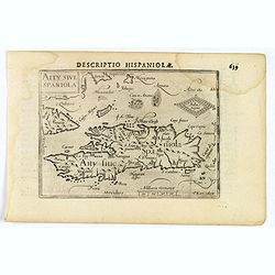
Decriptio Hispaniolae.
A miniature map of Hispaniola, (modern day Haiti and Dominican Republic), as well as the extreme eastern parts of Cuba. With a simple strap-work title and a scale in Germ...
- $150 / ≈ €132
Date: Amsterdam, 1606
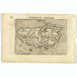
Descriptio Tercerae.
An attractive miniature map of The Azorian island of Terceira, in the Atlantic Ocean. Published by Petrus Bertius, in Amsterdam at the turn of the seventeenth century. Di...
- $100 / ≈ €88
Date: Amsterdam, 1606
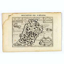
Sancta Helena.
An attractive small map of the south Atlantic island of St. Helena. Two years after the publication of the Itinerario, the first map of St. Helena appeared in 1598 in a m...
- $100 / ≈ €88
Date: Amsterdam, 1606
Gonsaluus Pizarrus wird uberwunden gefangen und enthauptet.
Pizarro returned to Spain in 1528 and appealed to the king to grant him permission to conquer Peru. With him, he brought gold and silver, as evidence of their potential w...
- $100 / ≈ €88
Date: Frankfurt, 1607
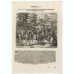
Ferdinandus de Soto Hauptmann uber das Kriegssvolck wardt sampt etlichen anderen von Pizarro, zu dem König Atabaliba abgesandt.
Hernando de Soto on horseback greets a native American carrying a scepter in the shape of a sun.They are surrounded by native American and Spanish soldiers. Includes war ...
- $100 / ≈ €88
Date: Frankfurt, 1607
Der König Atabaliba kompt mit grossem Pracht zu Caxamalca an.
The Inca king, Atahualpa or Atabaliba, holding a scepter in the shape of a sun is carried on a litter by native American soldiers. In the background is a fortified city. ...
- $100 / ≈ €88
Date: Frankfurt, 1607
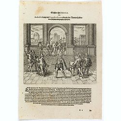
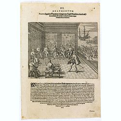
Atabaliba kompt mit Francisco Pizarro ubereyn der Rantzion halben die er für sein erledigung bezahlen solte. . .
Atahualpa or Atabaliba talks to Francisco Pizarro in a room with Spanish soldiers. Includes spears, guns or muskets, and dwellings. Accompanying Pizarro was a monk called...
- $100 / ≈ €88
Date: Frankfurt, 1607
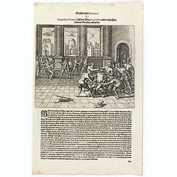
Als dem König Atabaliba zugesagt war dass er widerumb ledig werden solt schickte er die. . .
Spanish soldiers on horseback supervise native Americans who bring gold and silver vessels and statues to a fortified city. Includes vessels, animals such as a lobster, a...
- $100 / ≈ €88
Date: Frankfurt, 1607
Franciscus Pizarrus lässt den König Atabaliba wider verheissene trew und glauben auff . . .
Atahualpa who is chained to his chair is garroted or executed in a room with Spanish soldiers and blacks [slaves]. Includes spears, gun or musket, headdress, pole and rop...
- $100 / ≈ €88
Date: Frankfurt, 1607
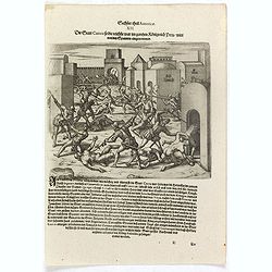
Die Stadt Cuzco so die reichste war in gantzen Königreich Peru wirdt von den Spaniern eingenommen.
Spanish soldiers fight in a fortified town against native Americans. Includes guns or muskets, swords, spears, fortifications, and scene of warfare.After Atahualpa was ki...
- $100 / ≈ €88
Date: Frankfurt, 1607
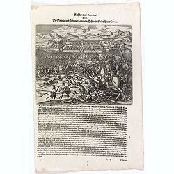
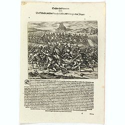
Die Spanier und Indianer halten eine Schlacht für der Stadt Cuzco.
Spanish soldiers, some on horseback, fight before a fortified town against native Americans. Includes guns or muskets, drums, swords, spears, fortifications, and scene of...
- $100 / ≈ €88
Date: Frankfurt, 1607
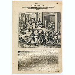
Didacus Almagrus wird von dem Ferdinando Pizarro in gefängnuss geworffen darinnen strangul. . .
Almagro returned to Cuzco, disillusioned and embittered from his long and fruitless journey south into Chile, where he had been searching for further wealth. This led to ...
- $100 / ≈ €88
Date: Frankfurt, 1607
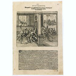
Margraff Pizarrus wird von Didoco Almagro dem jüngern mit hülff seiner Bundgenossen in . . .
Almagro’s son planned to take revenge on Pizarro for his father’s death. In 1541, with the help of Juan de Herrada and other Almagro supporters, they besieged Pizzaro’s r...
- $100 / ≈ €88
Date: Frankfurt, 1607
Die Schlacht zwischen Vaca de Castro, und Almagro dem jüngern.
Even before Pizarro’s death, a new royal governor, Vaca de Castro, was on his way to settle the turmoil in Peru. He refused to accept Almagro the younger, when he heard h...
- $150 / ≈ €132
Date: Frankfurt, 1607
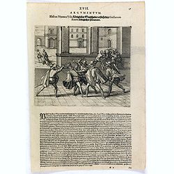
Blascus Nunnez Vela Königlicher Statthalter ersticht den Guillanum Xuarez Königlichen Proc. . .
Life under the new governor, Vaca de Castro, was no more stable than before and the king of Spain was eventually forced to send out yet another governor to replace him. H...
- $150 / ≈ €132
Date: Frankfurt, 1607
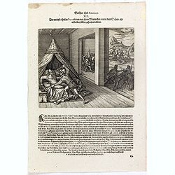
Der meinste theil in Peru ubten nur ihren mutwillen under dem schein als ob sie Kay. May. gehorsam leisten.
A Spanish gentleman is stabbed in bed by a soldier. In the background other men are killed or murdered. Includes swords, spears, canopy, and knife. The self-appointed gov...
- $150 / ≈ €132
Date: Frankfurt, 1607
Die Spanier gehen gantz Tyraiñsch mit den Indianern umb welche nicht fort kommen mochten . . .
As Pedro de la Gasca advanced from the north with about 1,500 soldiers, the journey from Trujillo to Ayacucho up the Eastern Cordillera was a terrible experience for the ...
- $100 / ≈ €88
Date: Frankfurt, 1607
![Dess Ferdinandi und Petri de Contreras, gefangene Kriegssknecht werden zu Ranama [sic] durch den Statt Schultheissen mit einem Dolchen durchstochen.](/uploads/cache/37003-250x250.jpg)
Dess Ferdinandi und Petri de Contreras, gefangene Kriegssknecht werden zu Ranama [sic] durch den Statt Schultheissen mit einem Dolchen durchstochen.
Men are stabbed inside prisons while chests are loaded onto a boat. Includes men hanging from a tree seen through a barred window, chains, shackles, pillory, and knife. T...
- $100 / ≈ €88
Date: Frankfurt, 1607
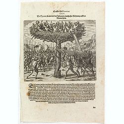
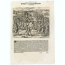
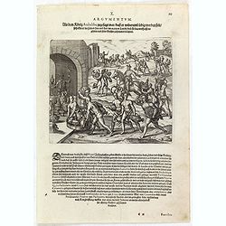
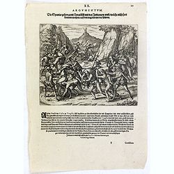
Die Spanier streiten mit den Indianern welche ihre Wohnung auff den Bäumen haben.
Native Americans in trees drop stones, shoot with arrows, and pour water on Spanish soldiers who attack from the ground. One man chops at a tree trunk while two others ho...
- $150 / ≈ €132
Date: Frankfurt, 1607
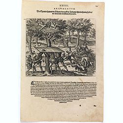
Die Spanier hawen die Bäume darauff die Indianer ihre wohnung haben mit Axten umb und stürtzen sie herunder.
Native Americans in trees drop stones on Spanish soldiers who attack from the ground. One man chops at a tree trunk while two others hold boards over his head to protect ...
- $100 / ≈ €88
Date: Frankfurt, 1607
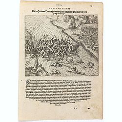
Wie der Indianer Brucken seyen von Seilen zusammen geflochten und vom Farth Guaynacapae.
Native Americans cross a net bridge over a river while one group cuts the end of it causing men to fall into the river and drown. Includes war clubs, spears, bows and arr...
- $100 / ≈ €88
Date: Frankfurt, 1607
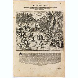
Die Spanier treiben allerhand Unzucht mit den Indianischen Weibern die sie in dem läger unnd Wasserbädern ergriffen nach dem Atabaliba gefangen worden.
Spanish soldiers march past a pool where native American women are bathing. Some of the soldiers drag some of the women away. After the defeat of the Inca king, some of t...
- $150 / ≈ €132
Date: Frankfurt, 1607

Polus Arcticus cum vicinis regionibus.
1608 MERCATOR, G. / HONDIUS, J. - Rare map of the North Pole, shown as a rocky island surrounded by 'in-drawing seas' between four huge islands
Date: Amsterdam, 1608
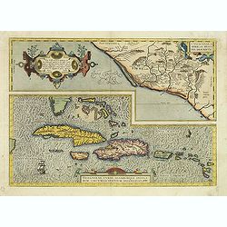
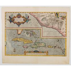
Cuba Insula. Hispaniola.
Decorative engraved map of Cuba above Hispaniola with smaller insets of Havana, Jamaica, Puerto Rico and Margarita.From the first French-text edition of Jodocus Hondius''...
- $300 / ≈ €264
Date: Amsterdam, 1608
Hispaniolae, Cubae Alliarumique Insularium
Two maps on one sheet: one of the Viceroyalty of Culiacan in Northwestern Mexico and one of the Caribbean. Based on Mercator's 1569 world map, Guttierez' America map of 1...
Date: Antwerp, 1609
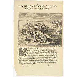
V. Inusitata Terrae Concussio, in Insula S. Michael Facta.
Showing the Vila Franca earthquake on 26 July 1591Theodore de Bry, a German engraver and book dealer, began a compilation of early voyages in 1590 and had published six p...
- $75 / ≈ €66
Date: Frankfurt, 1609

Tartariae sive Magni Chami Imperium.
This is a very early depiction of the northern Pacific, with the first mapping of Northwest Coast of America and probably the first map to name California 'C. Califormio...
Date: Antwerp, c. 1608-1612
Caarte vande nieuwe Passagie bezuijden de Strate Magellan. . . / Description de nouveau passage vers le zud du destroit de Maggellan. . .
Map showing the new route around the bottom of South America discovered by Schouten and Le Maire: through the Le Maire Strait, around the Barnevelt Islands, and past Cape...
Date: Frankfurt am Main, 1619
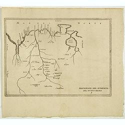
Descripcion del audiencia del Nuevo Reino 9.
The earliest map to include information from the previously secret manuscript maps of the Spanish cosmographer, Juan López de Velasco, showing present-day Colombia and Ve...
- $450 / ≈ €395
Date: Amsterdam, Michel Colin, 1622
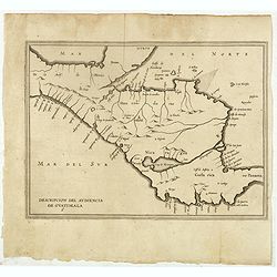
Descripcion del audiencia de Guatimala 6
The earliest map to include information from the previously secret manuscript maps of the Spanish cosmographer, Juan López de Velasco, showing part of Central America, in...
- $400 / ≈ €352
Date: Amsterdam, Michel Colin, 1622
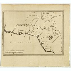
Descripcion del destricto del audiencia de la Nueva Galicia. 5.
The earliest map to include information from the previously secret manuscript maps of the Spanish cosmographer, Juan López de Velasco, showing part of Central America, in...
- $300 / ≈ €264
Date: Amsterdam, Michel Colin, 1622
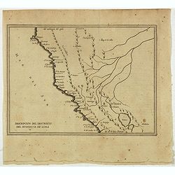
Descripcion Del Destrieto Del Audiencia De Lima. (Peru, and parts of Colombia, and Brazil)
Rare early map of the Audiencia of Lima, locating rivers and settlements, the earliest map to include information from the previously secret manuscript maps of the Spanis...
- $475 / ≈ €417
Date: Amsterdam, Michel Colin, 1622
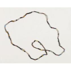
Dutch Trade Bead.
An extremely rare necklace made from authentic early 17th-century glass beads produced in the Netherlands. This rare and early Dutch Trade bead is built up from irregular...
Date: Middelburg, before 1623
Americae sive Indiae Occidentalis.
Hessel Gerritsz., the author and probable engraver of the map had seen maps of California as an island, but he relies on the more trustworthy accounts, such as Herrera, i...
- $1000 / ≈ €879
Date: Leiden, 1625
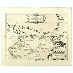
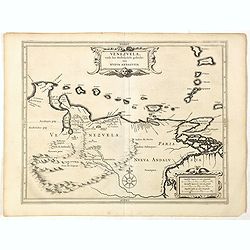
Venezuela, atque Occidentalis Pars Novæ Andalusiae.
The coastline of Venezuela with little interior development. Including Aruba, Bonaire, Curaçao, etc. This scarce map was prepared by Hessel Gerritsz (1581-1632), a former...
- $600 / ≈ €527
Date: Leiden, 1625
Hispania Nova.
The rare Samuel Purchas' edition of the Mercator/Hondius Atlas Minor atlas map. This was the standard map of the area for a generation. The map shows an area correspondin...
Date: London, 1625
Sudseite des Landts Terza del Fuoco, abgezeichnet durch Iohan von Walbeck.
Map showing Cap Horn and the Terra del Fuego.From a German text edition of Theodor de Bry's travel book. The original copper plate is now shortened at the left side and h...
Date: Frankfurt am Main, 1630
America sive India Nova.
This map was created by Michael Mercator, grandson of the great Gerard Mercator. It is the only map attributed to him. The map first appeared in 1595, one year after the ...
- $3000 / ≈ €2637
Date: Amsterdam, 1630
Venezuela, atque Occidentalis Pars Novæ Andalusiae.
Coastline of Venezuela with little interior development. Including Aruba, Bonaire, Curaçao, etc. Scarce map prepared by Hessel Gerritsz (1581-1632), former apprentice of ...
- $600 / ≈ €527
Date: Leiden, Elzevier, 1630
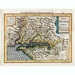
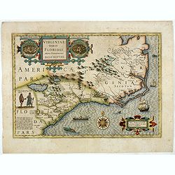
Virginiae item et Floridae . . .
Map of Virginia from the rare Cloppenburg edition slightly larger format and more scarce edition of the Mercator/Hondius "Atlas Minor". Engraved by Pieter Van D...
Date: Amsterdam, 1630
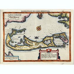
Description des Isles Bermudas.
Map of Bermuda from the rare Cloppenburg edition slightly larger format and more scarce edition of the Mercator/Hondius "Atlas Minor". Engraved by Pieter Van De...
Date: Amsterdam, 1630
Virginiae item et Floridae. . .
Cummings describes it as one of the most beautifully executed maps ever made of the Southeast. In detail and in general conception it surpasses all earlier maps of the re...
- $2200 / ≈ €1933
Date: Amsterdam, 1630
![Hanc Tabulam continens Laetam Pharnambuci.. . [Brazil].](/uploads/cache/16521-250x250.jpg)
Hanc Tabulam continens Laetam Pharnambuci.. . [Brazil].
An extremely rare and decorative map of coast-line of Pernambuco. With one inset: In the upper left corner a map of Brazil, with title in five lines Dutch and five lines ...
Date: Amsterdam, 1630
![[Montezuma's dream as told by a labourer, predicts calamties to come.]](/uploads/cache/40371-250x250.jpg)
[Montezuma's dream as told by a labourer, predicts calamties to come.]
An apocalyptic scene of Montzuma's dream .In 1631 Johann Ludwig Gottfried, inherited the Theodor De Bry’s publishing firm, among the illustrated accounts of the expeditio...
- $100 / ≈ €88
Date: Frankfurt, M.Merian, 1633
![[Last of the Pizzaro brothers killed.]](/uploads/cache/40356-250x250.jpg)
[Last of the Pizzaro brothers killed.]
Conflict between Gonzalo Pizarro and the latest officially appointed governor of Peru, Pedro de la Gasca, reached a climax in 1548 when Gasca’s forces crossed the Apurima...
- $80 / ≈ €70
Date: Frankfurt, M.Merian, 1633
![[Columbus taken prisoner, and sent back to Spain.]](/uploads/cache/40358-250x250.jpg)
[Columbus taken prisoner, and sent back to Spain.]
This engraving depicts the arrest of Columbus and his brothers. Bobadilla (sent by Spain, at Columbus’ request, to settle a revolt) reached Santo Domingo August 23, 1500 ...
Date: Frankfurt, M.Merian, 1633
![[The Dutch covalesce on the Isle Santa Clara.]](/uploads/cache/40359-250x250.jpg)
[The Dutch covalesce on the Isle Santa Clara.]
Fanciful map of the Island of Santa Clara (Isla Do Francez), as seen by the Dutch in 1599, during the exploration of Olivier de Noort, published by Theodore de Bry, one y...
Date: Frankfurt, M.Merian, 1633
![[Indian caciques are held for ransom.]](/uploads/cache/40360-250x250.jpg)
[Indian caciques are held for ransom.]
Gutierrez held the Indian caciques ransom. He said they would be released in exchange for enough gold to fill a basket six times over. Later, some of the Indians bought g...
- $100 / ≈ €88
Date: Frankfurt, M.Merian, 1633
![[Nicaraguan's dancing.]](/uploads/cache/40361-250x250.jpg)
[Nicaraguan's dancing.]
Each province organized its own festivities and people would come to a place of open land therein, which had been swept clean for dancing. The dancers were accompanied by...
- $100 / ≈ €88
Date: Frankfurt, M.Merian, 1633
![[Collective suicide under Spanish rule.]](/uploads/cache/40480-250x250.jpg)
[Collective suicide under Spanish rule.]
The natives of Hispaniola, who saw no end to the fearful oppression of Spanish rule, preferred death. So many, devoid of all hope, went into the woods to kill their child...
- $80 / ≈ €70
Date: Frankfurt, M.Merian, 1633
![[How the women tease their captives.]](/uploads/cache/40478-250x250.jpg)
[How the women tease their captives.]
The Indian women led their captive, Staden, into the middle of the hamlet. Then they decorated his head with feathers and his legs with rattles. After forming a circle ro...
Date: Frankfurt, M.Merian, 1633
![[Columbus lands on the Island of San Salvador.]](/uploads/cache/40479-250x250.jpg)
[Columbus lands on the Island of San Salvador.]
On 12th October 1492, after 33 days at sea, Columbus sighted land. His three ships made their way round the south-west point of an island Columbus named San Salvador - be...
- $100 / ≈ €88
Date: Frankfurt, M.Merian, 1633
