Browse Listings in America
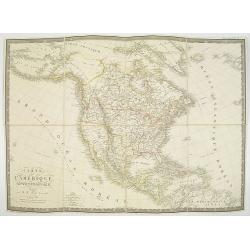
![[North America]](/uploads/cache/25907-250x250.jpg)
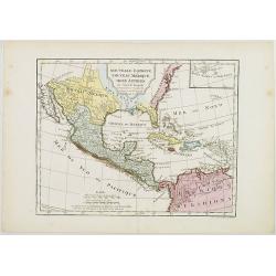
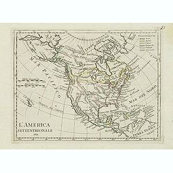
[North America]
Uncommon map of North America. The young United States incorporates the upper Midwest, with the remaining western territories of Louisiana, Nouveau Mexique, Nouveau Albio...
Date: Augsburg, ca. 1790
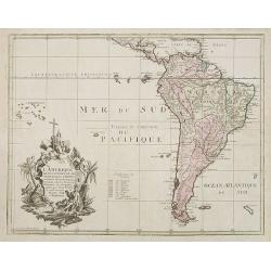
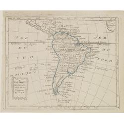
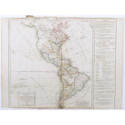
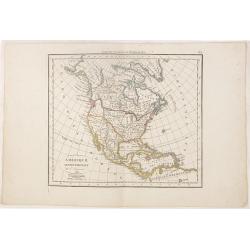
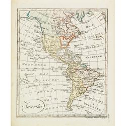
L'Amerique selon l'Etendue de Ses Principales Parties et don't les Points Principaux. . .
Uncommon map of South America, decorated with an elaborate cartouche referring to the conversion of the natives to Christianity, with natives bowing to a figure holding a...
Date: Augsburg, ca. 1790

Uomo del Paraguai nell' America Meridionalle. / Homme du Paraguai dans l'Amerique Meridionalle.
Full portrait of a person from Paraguay. From "Raccolta di stampe." a series of historically significant eighteenth-century copper plate engravings by Venetia...
Date: Venice, Antonio Zatta, c.1790

Indiana del Perù. / Indienne du Perou.
Portrait of a Peruvian Indian woman holding a fruit basket and a lama in the background. From "Raccolta di stampe." a series of historically significant eight...
Date: Venice, Antonio Zatta, c.1790

Dona del Regno di Granata. / Femme du Roy.me de Granade.
A full portrait of a woman from Granada, situated at Lake Nicaragua or Cocibolca. From "Raccolta di stampe", a series of historically significant eighteenth...
Date: Venice, Antonio Zatta, c.1790

Uomo del Canale di Noël della terra del Fuoco, nel Mar Australe. / Homme du Canal de Noël de la terre de Feu dans la Mer Australe.
Full portrait of a man from Christmas Sound, in Tierra del Fuego This engraved print on laid paper is from "Raccolta di stampe," a series of historically sign...
Date: Venice, Antonio Zatta, c.1790
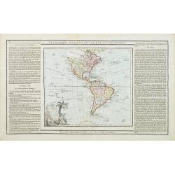
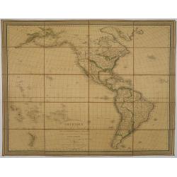
L' Amerique dressée pour l'étude de la géographie . . .
Map showing the American continent. California with a large inlet. Some major cities, bodies of water, and geographic features are marked. There are illustrations of ship...
- $200 / ≈ €173
Date: Paris, 1790
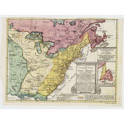
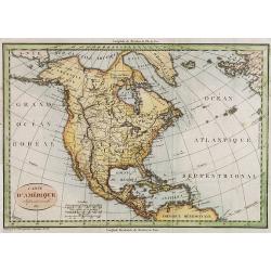
Die Vereinigten Staaten von Nord Amerika..
Uncommon map of the east coast of North America, including the Great Lakes area. To the right inset map of New Foundland. After the map by William Faden of 1783. With col...
- $500 / ≈ €433
Date: Germany, 1790

Uomo del Perù. / Homme du Perou.
Full portrait of a Peruvian warrior. From “Raccolta di … stampe.” a series of historically significant eighteenth-century copper plate engravings by Venetian engrav...
Date: Venice, Antonio Zatta, c.1790
De vereenigde staten van Noord America.
Rare miniature map of Eastern United States. The map carries the signatures of W.Holtrop and the engraver H.Klokhoff. Steven van Esveldt's business was carried on by his ...
- $450 / ≈ €389
Date: Amsterdam, 1791

Bison Iubatus.
Etching of a bison by Leendert Brasser (1727 - 1793) after a painting of the Dutch artist Gerrit van den Heuvel.An early portrait of a bison, etched by Leendert Brasser (...
Date: Rotterdam, 1766-1793
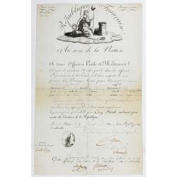
Passeport.
Passport for the United States in the name of Madeleine Lavit Femme Lory, issued by the Commission of Interior Relations and approved by the Committee of Public Safety.Th...
Date: Paris, 1795
![Mappa Mondo tagliato sulpiano di unmeridiano Emisfero Occidentale. [togther with] … Orientale.](/uploads/cache/48543-250x250.jpg)
Mappa Mondo tagliato sulpiano di unmeridiano Emisfero Occidentale. [togther with] … Orientale.
World map on two sheets - Western Hemisphere (North and South America, Oceania, Greenland) and Eastern Hemisphere (Europe, Africa, Asia, Australia). Published by Pazzini,...
- $500 / ≈ €433
Date: Siena, 1796

New Jersey entworfen von D.F. Sotzmann. Hamburg bey Carl Ernst Bohn 1796 . . . NO.VIII
Extremely rare map of New Hampshire prepared by Daniel Friedrich Sotzmann for Christopher Ebeling's "Erdbeschreibung von Amerika", a project ended after only te...
Date: Hamburg, Carl Ernst Bohn, 1797

Rhode Island entworfen von D.F. Sotzmann. Hamburg bey Carl Ernst Bohn 1798 . . . NO.V
Extremely rare map of Rhode Island prepared by Daniel Friedrich Sotzmann for Christopher Ebeling's "Erdbeschreibung von Amerika", a project ended after only ten...
Date: Hamburg, Carl Ernst Bohn, 1797
![Le Isole di Sandwich delineate sulle osservazioni del Cap Cook. [Hawaii]](/uploads/cache/43195-250x250.jpg)
Le Isole di Sandwich delineate sulle osservazioni del Cap Cook. [Hawaii]
FIRST EDITION on laid paper. Cassini’s splendid map depicts the Sandwich Islands, the old name for the Hawaiian Islands, at the end of the eighteenth century. The splen...
Date: Rome, 1798
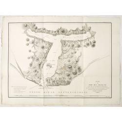
Plan du Port des Francais sur la Cote du Nord-Ouest de l'Amerique, par 58°37' de Latitude Nord et 139°50' de Longitude Occidentale, Decouverte le 2 Juillet 1786, par les Fregates Francaise la Boussole et l'Astrolabe.
Chart of the entrance of Bassin de L'Quest , visited on July 2nd 1786 by La Perouse. On many 18th century maps we find a depiction of Mer de L'Quest or Sea of the West a ...
- $500 / ≈ €433
Date: Paris, 1798

An Emblem of America / An Emblem of Africa / An Emblem of Asia / An Emblem of Europe.
An Emblem of America : This white female figure of Columbia, emblematic of the United States, represents America in a set of prints of the Four Continents. Standing besid...
Date: London, 1798

New Yok entworfen von D.F. Sotzmann. Hamburg bey Carl Ernst Bohn 1799 . . . NO.VII
An extremely rare map of New York prepared by Daniel Friedrich Sotzmann for Christopher Ebeling's "Erdbeschreibung von Amerika", a project ended after only ten ...
Date: Hamburg, Carl Ernst Bohn, 1799

Carte des côtes du Golfe du Mexique compris entre la pointe sud de la presqu'Ile de la Floride et la pointe nord de la presqu'Ile d'Yucatan:...
Detailed and important early chart of the Gulf Coast and Florida and dated 1800. First French edition of "the first printed [map] to show and name Galveston Bay&qu...
Date: Paris, 1800
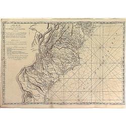
Carte Réduite des Côtes Orientales Del'Amérique Septentrionale Contenant partie du Nouveau Jersey, la Pen-sylvanie, le Mary-land, la Virginie, la Caroline Septentrionale, la Caroline Méridionale et la Georgie. . .
Scarce Rome edition of an French map made expressly for use of the French Navy during the American Revolution. Covering the area of Maryland, North and South Virginia. Ph...
- $900 / ≈ €779
Date: Genova, Yves Gravier, c.1800

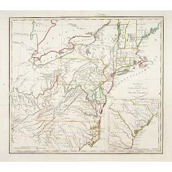
Carte de la partie septentrionale des Etats Unis..
An attractive 1801 map of North America's east coast north of Long Island. Including St.Laurence River as far south as Lake Ontario. Engraved by André and P.F.Tardieu. A...
Date: Paris, 1801

United States of North America. Carte des Etats-Unis de l'Amerique Septentrionale / copiée et gravée sur celle d'Arrowsmith, corrigée et considérablement augmentée... par P. F. Tardieu...
FIRST EDITION. An impressive wall map here in 4 unjoined sheets and large margins. RARE in these untouched, full sheets. Recorded examples are usually offered as folding ...
Date: Paris: An XI - 1802
![[Lot of 5 maps] Kaart van de noord-west kust van Amerika en de noord-oost kust van Asia.](/uploads/cache/19136-250x250.jpg)
[Lot of 5 maps] Kaart van de noord-west kust van Amerika en de noord-oost kust van Asia.
- Kaart van de noord-west kust van Amerika en de noord-oost kust van Asia. Opgenoomen in de Jaaren 1778 en 1779. Captain James Cook (1728-79), explorer, circumnavigato...
Date: Leiden, 1795-1803
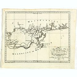
Charte von der mündung des Mississippi. Weimar, Verlage des Landes Indust. Compt. 1803.
Scarce map showing the mouth of the Mississippi into the Gulf of Mexico. With Pensacola in Western Florida, Mobile Bay in Alabama and Louisiana with New Orleans and their...
- $300 / ≈ €260
Date: Weimar, 1803

Géographie des Plantes Equinoxiales - Tableau physique des Andes et pays voisins. . .
Physical Portrait of the Andes and adjacent lands", organized around the Chimborazo and Cotopaxi volcanoes in Ecuador.With local vegetation is illustrated pictoriall...
Date: Paris, 1805
Nouvelle Espagne, Nouveau Méxique, Isles Antilles, par Robert de Vaugondy corrigés par le Cen. Lamarche Géog. Successeur de Vaugondy. l''An 3e.
Although dated 1794/95 [l'An 3e.], the map is a copy of an earlier map which appeared in Robert de Vaugondy's 1778 atlas. Hence, it does not show the newly independent Un...
- $300 / ≈ €260
Date: Paris, 1794 - 1806

Paraguay, Chili, Terre Magellan ?
Map of Paraguay, Chili, and Argentina . By C. F. Delamarche, successor of Robert de Vaugondy, Geographer.
Date: Paris, 1794 -1806

Homme & Femme Ottawas.
Hand-colored mezzotint of Native Americans engraved by Félix Mixelle and Lachaussée Jeune after Jacques Grasset de Saint-Sauveur.As an etcher, drawer and writer, Grasse...
- $75 / ≈ €65
Date: Paris,1801-1806
L'Amérique Méridionale, Divisée en ses Principaux Etats.
Map of South America, from Atlas de la Géographie de toutes les parties du monde .. Ouvrage destiné pour l'education, et nécessaire aux négocians, aux voyageurs, aux ...
Date: Paris, Prudhomme, Levrault, Debray, 1806
Carte de la Nouvelle Angleterre, Nouvelle York, Nouvelle Jersey, et Pensilvanie.
Map of the north eastern part of the United States, from Atlas de la Géographie de toutes les parties du monde .. Ouvrage destiné pour l'education, et nécessaire aux n...
Date: Paris, Prudhomme, Levrault, Debray, 1806

Carte Réduite Du Golphe Du Mexique Et Des Isles De L' Amérique..
A well engraved and highly detailed chart prepared by Bellin of the Gulf of Mexico and the Caribbean. In addition to a magnificent title cartouche and a color key to the ...
Date: Paris dated year 17, or 1808
![A Toopapaoo of a Chief, with a priest making his offering to the Morai, in Huoheine. [Huaheine - the Society Islands]](/uploads/cache/30045-250x250.jpg)
A Toopapaoo of a Chief, with a priest making his offering to the Morai, in Huoheine. [Huaheine - the Society Islands]
A view of a chief's raised burial chamber in Huaheine, Society Islands, taken from "Views in the South Seas" being a very important and early view depicting sce...
Date: London, Boydell and Co., 1808
West indien.
Nice small map of The West Indies, with Cuba, Jamaica, S.Domingo, etc. Southern tip of Florida is included. Map by Johannes Walch in his rare Allgemeiner Atlas Nach den b...
Date: Augsburg, 1812
Amerique ou Indes Occidentales..
Fine map of the Western Hemisphere with on right hand side geographical index tables with also mentioning the Spanish, English, French, Danish possessions. Prepared by Ro...
Date: Paris, 1812
Amérique, réduite d'après celles d'Arrowsmith en 4 flles Par J.N.Champion, Ingénieur-Geographe et . . . Nouvelles découvertes de Clacke et du Major Pike . . .
A charming folding-map of America, drawn by J.N. Champion. The title explains that the map used the latest information by Alexander Humboldt and Clarck and Pike. Dated 18...
- $500 / ≈ €433
Date: Paris, 1815
Carte d' Amérique Septentrionale 1817.
Map of North and Central America. Engraved by E.Collin, active at 23, quai des Augustins, Paris.
- $300 / ≈ €260
Date: Paris, 1817
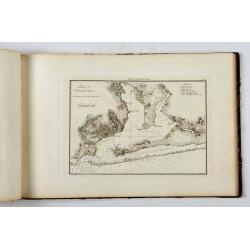
Little Egg Harbour.
A small sea chart showing Little Egg Harbour east of Tucker's Island. This map was published in the “American Coast Pilot”, a detailed guide to harbors, capes and hea...
- $50 / ≈ €43
Date: New York, 1817
Portulano de la Ameririca Setentrional construido en la direccion de tabajos.
The "Portulano de la America Setentrional", is an exceedingly rare Spanish sea atlas featuring charts of the Caribbean and the Gulf of Mexico. It was developed ...
Date: Madrid, 1818
![Etats-Unis de L'Amerique Septentrionale. [Two sheets in manuscript ]](/uploads/cache/03972-250x250.jpg)
Etats-Unis de L'Amerique Septentrionale. [Two sheets in manuscript ]
Two sheets giving detailed information in French about the population in 1810, principal cities, products of industry and commerce, the financial situation for 1818, etc....
Date: France, ca. 1819
Gedeelte van den Vereenigden Staat van Noord Amerika.
A rare an detailed map of the eastern part of the United States of America. After Isaac Weld's map from his Travels through the States of North America 1799. Barbara Back...
- $650 / ≈ €563
Date: Netherlands c. 1820

Manuscript plan of Havana harbour.
Manuscript chart with good nautical detail and soundings of Havana harbour.
Date: Spain c.1820

Carte générale de l' Amérique divisée en ses principaux états . . .
Map of North and South America. By C. F. Delamarche, successor of Robert de Vaugondy, Geographer. Descriptive text to the left.
Date: Paris, 1820
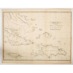
MAP OF THE Route of Columbus on arriving among the Bahama Islands.
An impressive detailed chart of the Bahama Bank, plus surrounding smaller islands, plus most of Cuba, Jamaica, Saint Domingo (Dominican Rep & Hayti). The map has grid...
Date: New York, ca.1820
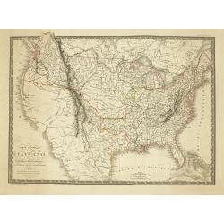
Carte Generale des Etats-Unis De L'Amerique Septentionale . . .
One of the earliest obtainable maps to show the United States From Coast to Coast, published in Paris by A.H. Brue.The map is especially interesting west of the Mississip...
Date: Paris, 1820
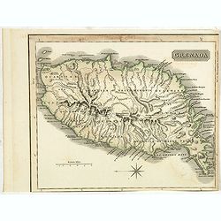
Grenada.
A delightfully detailed map the West Indian island Grenada by John Thomson. The map displays excellent detail concerning roads, rivers, towns, bays, harbours and other in...
- $50 / ≈ €43
Date: Edenburgh, 1821
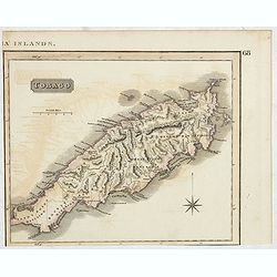
Tobago.
A delightfully detailed map of the West Indian island Tobago by John Thomson. The map displays excellent detail concerning roads, rivers, towns, bays, harbors, and other ...
- $50 / ≈ €43
Date: Edenburgh, 1821
![[ First Separate Map of Michigan Territory ] Geographical, statistical, and historical map of Michigan territory.](/uploads/cache/25931-250x250.jpg)
[ First Separate Map of Michigan Territory ] Geographical, statistical, and historical map of Michigan territory.
The map illustrates Michigan Territory and the so-called "Indian Line" shortly after the Treaty of Chicago (1821), the third of three treaties with the Native A...
Date: Philadelphia, 1822
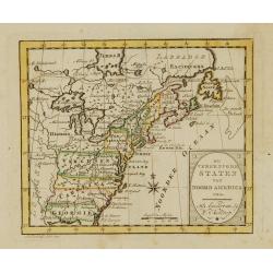
L'America septentrionale.
Charming and finely engraved map of North America from the rare atlas Atlante Tascabile o sia Serie di Num. XXI Cartine Geografiche nelle quali si rappresenta in ristrett...
- $275 / ≈ €238
Date: Rome, 1823

Map of Pensylvania and New Jersey by H.S. Tanner.
First edition of this rare and important map of Pennsylvania and New Jersey by H.S. Tanner and published in his "New American Atlas" from 1823. Includes roads, ...
Date: Philadelphia, Henry Tanner, 1823
Amérique septentrionale.
A fine map of North America published by the well-known Paris publisher of maps, globes and atlases C.F. Delamarche.
- $110 / ≈ €95
Date: Paris, 1824
Amerika
Scarce miniature map of the Western Hemisphere.
- $200 / ≈ €173
Date: Augsburg, 1824

System of Penal Law, prepared for the State of Louisiana , comprising codes of offenses and punishments, of procedure, of prison discipline, and of evidence applicable as well to civil as to criminal cases.
The "Enquiries" of Rush and Bradford and the Pennsylvania movement toward abolition of the death penalty had a little immediate impact on the practices of other...
Date: New-Orleans, Benjamin Levy, 1824
![Carte Géographique [ . . .] de la Pensylvanie.](/uploads/cache/14221-250x250.jpg)
Carte Géographique [ . . .] de la Pensylvanie.
Detailed map of Pennsylvania. From J.A. Buchon, Atlas Gégraphique Statistique, historique et chronologique des deux Amériques et des isles adjacentes. traduit de l'atla...
- $250 / ≈ €216
Date: Paris, 1825
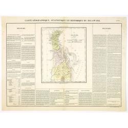
Carte Géographique .. Delaware.
Detailed map of Delaware. From J.A. Buchon, Atlas Gégraphique Statistique, historique et chronologique des deux Ameriques et des isles adjacentes, traduit de l'atlas ex�...
- $300 / ≈ €260
Date: Paris, 1825
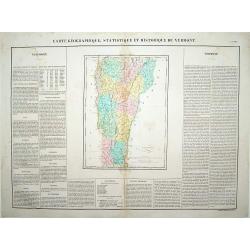
Carte Géographique .. Vermont.
Detailed map of Vermont. From J.A. Buchon, Atlas Gégraphique Statistique, historique et chronologique des deux Amériques et des isles adjacentes: traduit de l'atlas ex�...
- $250 / ≈ €216
Date: Paris, 1825
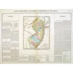
Carte Géographique .. New Jersey.
Detailed map of New Jersey. From J.A. Buchon, Atlas Gégraphique Statistique, historique et chronologique des deux Amériques et des isles adjacentes: traduit de l'atlas ...
- $300 / ≈ €260
Date: Paris, 1825
Carte de l'Amerique septentrionale Rédigée par A.H.Brué géographe.
Detailed dissected folding-map of North and Central America by Brué, originally published in Atlas Universel but here mounted on linen and intersected in 8 parts. Next t...
- $250 / ≈ €216
Date: Paris, 1825

The Traveller's Guide. A Map Of The Roads, Canals And Steam Boat Routes Of The United States ... Designed for the use of Travellers, By H.S. Tanner.
Rare first edition of Tanner's travel map in pocket map form, in it original red leather covers, with the map and no text, as issued. Ristow says the first edition was 18...
Date: Philadelphia, 1825
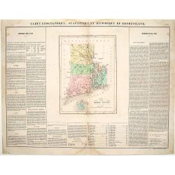
Carte Géographique, statistique et historique du Rhode Island.
Detailed map of Rhode Island. From J.A. Buchon, Atlas Gégraphique Statistique, historique et chronologique des deux Amériques et des isles adjacentes, traduit de l'atla...
- $175 / ≈ €151
Date: Paris, 1825
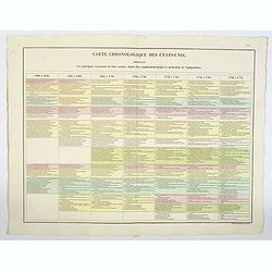
Carte Chronologiquedes Etats-Unis.
A hand colored historical timeline table (in French), highlighting "the main [historical] events in the years from their establishment to the declaration of independ...
- $100 / ≈ €87
Date: Paris, 1825
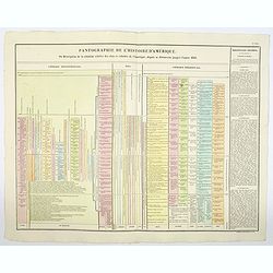
Pantographie de l'Histoire d'Amerique, ou Description de la situation relative des etats et colonies de l'Amerique. . .
An attractivelooking hand colored historical timeline table (in French), charting important historical events and discoveries of America and their States and Colonies sin...
- $100 / ≈ €87
Date: Paris, 1825
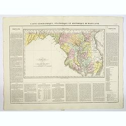
Carte Geographique, Statistique ey Historique du Maryland.
A lovely, detailed map of Maryland, from Buchon's, Atlas Gégraphique Statistique, historique et chronologique des deux Ameriques et des isles adjacentes, traduit de l'at...
- $100 / ≈ €87
Date: Paris, 1825
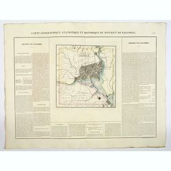
Carte Geographique, Statistique ey Historique du District de Colombie.
A lovely, detailed map of the District of Columbia, (Washington) from Buchon's, Atlas Gégraphique Statistique, historique et chronologique des deux Ameriques et des isle...
- $100 / ≈ €87
Date: Paris, 1825
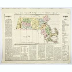
Carte Geographique, Statistique et Historique de Massachusetts.
A detailed map of Massachusetts, from Buchon's Atlas Gégraphique Statistique, historique et chronologique des deux Ameriques et des isles adjacentes, traduit de l'atlas ...
- $100 / ≈ €87
Date: Paris, 1825
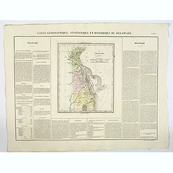
Carte Geographique, Statistique et Historique du Delaware.
A nice detailed map of Delaware, from Buchon's Atlas Gégraphique Statistique, historique et chronologique des deux Ameriques et des isles adjacentes, traduit de l'atlas ...
- $100 / ≈ €87
Date: Paris, 1825
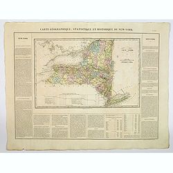
Carte Geographique, Statistique et Historique du New York.
A detailed map of State of New York, from Buchon's Atlas Gégraphique Statistique, historique et chronologique des deux Ameriques et des isles adjacentes, traduit de l'at...
- $100 / ≈ €87
Date: Paris, 1825
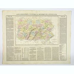
Carte Géographique, Statistique et Historique de la Pensylvanie.
A detailed map of Pennsylvania, from Buchon's Atlas Gégraphique Statistique, historique et chronologique des deux Amériques et des isles adjacentes, traduit de l'atlas ...
- $100 / ≈ €87
Date: Paris, 1825
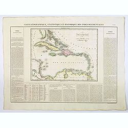
Carte Geographique, Statistique et Historique des Indes Occidentales.
A nice detailed map of The West Indies, including Cuba, the Bahamas, the southern most tip of FL, parts of Central America, and the northern tip of South America. From Bu...
Date: Paris, 1825

Carte Geographique, Statistique et Historique de l'Amerique Meridionale.
A nice detailed map of South America from Buchon's Atlas Gégraphique Statistique, historique et chronologique des deux Ameriques et des isles adjacentes traduit de l'atl...
Date: Paris, 1825

Carte Geographique, Statistique et Historique du Perou.
A nice detailed map of Peru from Buchon's Atlas Gégraphique Statistique, historique et chronologique des deux Ameriques et des isles adjacentes traduit de l'atlas exécu...
Date: Paris, 1825

Carte Geographique, Statistique et Historique de Buenos-Ayres.
A nice detailed map of what is today northern Argentina (Rep. of Buenos Ayres or the United Provinces of South America) from Buchon's Atlas Gégraphique Statistique, hist...
Date: Paris, 1825
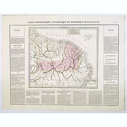
Carte Geographique, Statistique et Historique de la Guyane.
A nice detailed map of Guyana from Buchon's Atlas Gégraphique Statistique, historique et chronologique des deux Ameriques et des isles adjacentes traduit de l'atlas exé...
Date: Paris, 1825
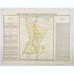
Carte Geographique, Statistique et Historique du Paraguay.
A nice detailed map of Paraguay from Buchon's Atlas Gégraphique Statistique, historique et chronologique des deux Ameriques et des isles adjacentes traduit de l'atlas ex...
Date: Paris, 1825
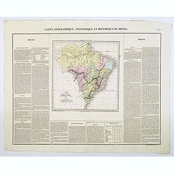
Carte Geographique, Statistique et Historique du Bresil.
A nice detailed map of Brazil from Buchon's Atlas Gégraphique Statistique, historique et chronologique des deux Ameriques et des isles adjacentes traduit de l'atlas exé...
Date: Paris, 1825
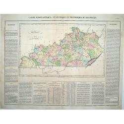
Carte Géographique .. Kentucky.
Detailed map of Kentucky. From J.A. Buchon, "Atlas Gégraphique Statistique, historique et chronologique des deux Ameriques et des isles adjacentes; traduit de l'atl...
Date: Paris, 1825

Missions et Résidences dans la Partie Septentrionale de l'Amérique Contenant 50 Jésuites.
Very rare missionary map of North America from "Atlas Universel indiquant les établissemens des Jésuites: avec la manière dont ils divisent la terre, suivi desév...
Date: Paris, Ambroise Dupont , 1826
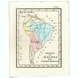
Prvinces des Jésuites dans l'Amerique méridionale.
Rare map of South America from "Atlas Universel indiquant les établissemens des Jésuites: avec la manière dont ils divisent la terre, suivi desévénemens remarqu...
- $200 / ≈ €173
Date: Paris, Ambroise Dupont , 1826

Portrait de George Washington.
Portrait of the first president of the United States of America.From Giulio Ferrario's work Le Costume ancien et moderne ou histoire du gouvernement, de la milice, de la ...
Date: Milan 1827

Danse d'indiens.
From Giulio Ferrario's work Le Costume ancien et moderne ou histoire du gouvernement, de la milice, de la religion, des arts, etc. published in Milan by the author betwee...
- $50 / ≈ €43
Date: Milan, 1827