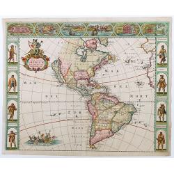
Browse Listings in America
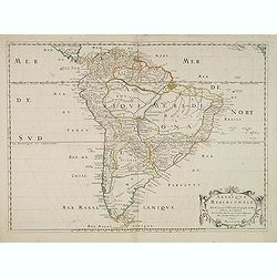
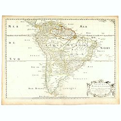
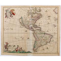
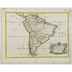
Amerique Meridionale. Par N.Sanson d'Abbeville. . .
The first edition of a cornerstone South America map, the first to show the boundaries of many countries, regions, and provinces. Peru is shown governing a huge tract of ...
- $500 / ≈ €433
Date: Paris, after 1650
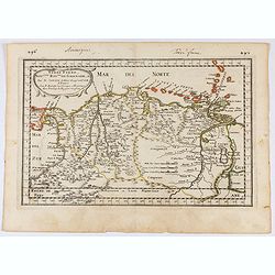
Terre Ferme, Nouveau Roy.me de Grenade..
Fine map of Colombia, Venezuela and the islands of Curaçao, Aruba, Bonaire, etc. Prepared by N.Sanson engraved by A.de Winter.
Date: Paris, 1656
![Mexico, Regia et Celebris Hispaniae Novae Civitas ... [on sheet with] Cusco, Regni Peru in Novo Orbe Caput.](/uploads/cache/29013-250x250.jpg)
Mexico, Regia et Celebris Hispaniae Novae Civitas ... [on sheet with] Cusco, Regni Peru in Novo Orbe Caput.
Two bird's-eye views on one sheet: Mexico and Cusco.Showing Mexico City and Cusco, the capital cities of the Aztecs and Incas, with the major buildings shown in profile w...
Date: Amsterdam, 1657
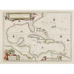
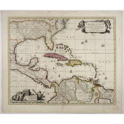
Insulae Americanae in Oceano Septentrionali cum Terris adiacentibus.
General map of the West Indies extending from Virginia to the mouth of the Orinoco, and destined to be copied in various shapes by many other publishers. Title cartouche ...
- $1500 / ≈ €1298
Date: Amsterdam, 1658
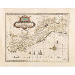
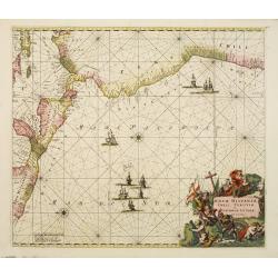
Peru.
Decorated with ships and monsters on the sea. Orientated with east at the top. Shows the Pacific coast of South America from Ecuador (at the left-hand side) as far south ...
- $400 / ≈ €346
Date: Amsterdam, 1658

Tabula Magellanica.
A map with Willem Blaeu's signature, but published by his son Joan, of South America's extremity with the Strait of Magellan and Le Maire Strait.The coastlines are depict...
Date: Amsterdam, 1658
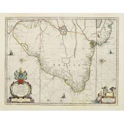
Brasilia.
A mint example of this map is by Krystof Arciszewski, a Polish general who worked for the Dutch West Indian Company. The map perpetuates various myths including the Parim...
- $1250 / ≈ €1082
Date: Amsterdam, 1658
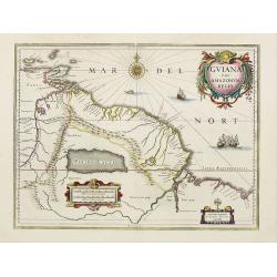
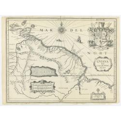
Guiana sive Amazonum Regio.
A very decorative map of Suriname which extends from the Isla Margarita in the northwest to the coast of northern Brazil near Sao Luis east of the Amazon delta. The map l...
- $450 / ≈ €389
Date: Amsterdam, 1658
Carte de L'AMERIQUE Corrigeé et argumenteé….
Separately published map published in 1658 but based on Petrus Bertius map of 1624., this on its turn taken from Jodocus Hondius map of 1618. On the sides he lists the pr...
Date: Paris, 1658
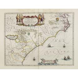
Virginiae Partis Australis, et Floridae Partis Orientalis.
Blaeu based this map on the Mercator-Hondius of 1606. A number of geographical improvements, however were incorporated, although two large fictions lakes accompanied by e...
Date: Amsterdam, 1658

Pascaerte van Brazil en Nieu Nederlandt van Cuorvo en Flores.
A rare chart of the Atlantic Ocean from the first edition of Hendrick Doncker's Zee-Atlas, of which no surviving example is known.Although the idea of its unusual coverag...
Date: Amsterdam, 1658
Amerique Meridionale. . . 1650.
First edition. A fine large map of South America, engraved by A.Peyrounin. The relatively unknown Amazon region is left without speculation. However, Sanson includes the ...
- $450 / ≈ €389
Date: Paris, 1650-1659

Pascaerte vande Caribische Eylanden, vande Barbados tot aende Bocht van Mexico ‘t Amsterdam By Hendrick Doncker. . .
First state. Rare. “This chart appeared in the first edition of Hendrick Doncker’s Zee-Atlas, of which no surviving example is known” -- Burden. This is an example ...
Date: Amsterdam, 1659
Nova Hispaniae, Chili, Peruviae, et Guatimalae Littorae..
A superbly decorative chart, oriented with north to the left of the sheet, covering the coasts of Central America, Peru, Chile, Jamaica and part of Cuba and Porto Rico. S...
- $1000 / ≈ €865
Date: Amsterdam, 1660

Poli Arctici, et circumiacentium terrarum descriptio novissima. . .
A re-issue of the Hondius' plate. A particularly decorative map of the North Pole with Iceland. Several Dutch names in Labrador. The toponymy in Canada reflects the conti...
Date: Amsterdam, 1660

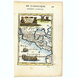
Paraquaria vulgo Paraguay cum adjacentibus.
Rare map only included in Joan Blaeu's Atlas major. Detailed map of Uruguay, Paraguay, Northern part of Argentina and northern part of Chili. Engraved by Gerard Coeck. Tw...
- $800 / ≈ €692
Date: Amsterdam, 1660

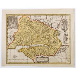
Nova Virginiae tabula.
A fine example of Blaeu's map of Virginia and the Chesapeake region is based on the first state of Smith's map, 1612, and is slightly larger and more expertly engraved.Th...
Date: Amsterdam, 1635/1660
![[Printed on silk] Nova Totius Americae Sive Novi Orbis Tabula, Auct. Hugo Allardt.](/uploads/cache/48420-250x250.jpg)
[Printed on silk] Nova Totius Americae Sive Novi Orbis Tabula, Auct. Hugo Allardt.
Hugo Allard’s ca. 1661 map of the Americas, showing California as an island printed on silk. This separately issued map printed on paper is quite rare on the market. T...
Date: Amsterdam, 1661

Mappa Aestivarum Insularum alias Barmudas.
Blaeu based his work on John Speed's remarkably accurate map of 1626-1627. It shows the island divided into tribes and lots, and below the map itself appear the names of ...
Date: Amsterdam, 1662
![Noweav Mexiqve [California as an Island]](/uploads/cache/03796-250x250.jpg)
Noweav Mexiqve [California as an Island]
Uncommon miniature map of California as a island, from Pierre Duval's La Geographie Universeille in a second state. The map is derived from Audience de Guadalajara (1657)...
Date: Paris, 1663
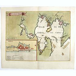
Sinus Omnium Sanctoru. Bahia de Todos os Sanctos.
RARE. First Atlas Major issue: originally issued by Blaeu in Casper van Baarle's 'Rerum per Octennium in Brasilia' (1647) dedicated to the former Governor of the Dutch co...
Date: Amsterdam, 1664
Nova Totius Americae descriptio.
First state of de Wit's first map of America, with figured borders on three sides. North America has a good overall outline, with a completed Hudson Bay and Baffin Island...
Date: Amsterdam, 1665

.Pascaerte Vande Zuyd-Zee tusschen California, en Ilhas de Ladrones. . .
A decorative and most interesting map - being one of the earliest of the Pacific to record the observations of Tasman's voyages. The northern part of the island of Califo...
Date: Amsterdam, 1666
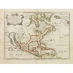
Americque Septentrionale. . .
A general map of North America shows California as an island, but with few names and a flat northern coastline. Prepared by N. Sanson and engraved by A.Peyrounin. A firs...
- $1000 / ≈ €865
Date: Paris, P. Marriete, 1667
Nouvelle description de lamerique.
Jollain published this rare map of America in 1667. State 3, with the scale, erased, as it fictitious strait on the west coast of North America which Le Royaume de Quiuer...
- $450 / ≈ €389
Date: Paris, 1667
Guiana sive Amazonum regio.
This very rare map shows northwest Latin America with Surinam and French Guiana and was engraved by Johann Philipp Thelott. The map comes from the work of Johann Joachim ...
Date: Frankfurt, 1669

Canibales Insulae.
Rare, early Dutch nautical chart of the Caribbean from Puerto Rico southward.
Date: Amsterdam, 1670
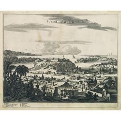
Portus Acapulco.
Attractive view of the city and harbor of Acapulco, showing fortifications, outlying buildings, ships in the harbor, costumed locals, etc.This map is taken from Ogilby's ...
- $300 / ≈ €260
Date: London, 1671
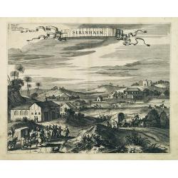
Serinhaim.
Fine view of a fort in Serinhaim, Brazil, with numbered key at the base. A procession of Portuguese or Dutch soldiers advance along the road carrying a litter. To the lef...
Date: London, 1671

Nova Virginia Tabula.
A beautifully engraved map, derived from the highly influential map by Captain John Smith in 1612, showing Chesapeake Bay and the surrounding area. The decoration of this...
Date: Amsterdam, J.Meurs, 1671

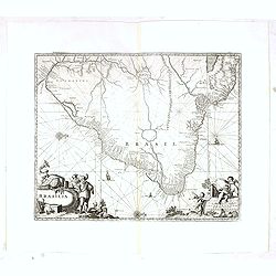
Brasila.
Map of Brazil extending from C. Nasou and Parime Lago to the Mouth of the Rio de la Plata. Oriented with West on top.The cartography of the region is quite primitive. The...
Date: Amsterdam, 1673

Yucatan . . . Et Guatimala Conventus Iuridicus.
Very attractive map encompassing the Mexican heartland, the Yucatan peninsula, and the old Spanish Audiencia of Guatemala including Honduras, Nicaragua, Costa Rica and pa...
Date: Amsterdam, 1673

Recueil de divers voyages faits en Afrique et en l'Amerique, qui n'ont point esté encore publiez.
First edition of this collection of significant and interesting voyages, edited by a scholar and book collector who served in the employ of Louis XIV before being appoint...
Date: Paris, Louis Billaine, 1674
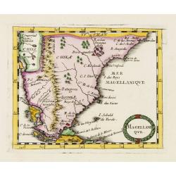
Magellani Que.
Uncommon miniature map of Argentina and Strait of Magellan from Pierre Duval's La Geographie Universeille dated 1676. Following his Cartes de geographie in 1657, Pierre D...
Date: Paris, 1676

Les Isles Terceres. . .
Uncommon map of the Azores. Engraved by Sommer. Du Val is mentioned as the cartographer and the publisher was Pierre Mariette.
Date: Paris, c. 1650 - 1676
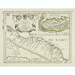
Coste de Guayane autrement Franc Equinoctale en la Terre-Ferme d'Amerique suivant les Dernières Relations . . .
Uncommon map of the French colony Guyana in southern American Guyana, with a detailed enlargement of Cayenne in the upper right corner ( 155X110mm.), with fine title cart...
Date: Paris, 1676
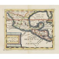
Mexique ou le N.Espagne.
Uncommon miniature map of Mexico, central America and the Gulf of Mexico. From Pierre Duval's La Geographie Universeille dated 1676. Following his Cartes de geographie in...
Date: Paris, 1676

Novissima et Accuratissima Totius Americae Descriptio.
Second state of Visscher's map of the Americas, this decorative map greatly influenced the cartography of the Americas both geographically and artistically.Although it di...
Date: Amsterdam, 1677
Novissima et Accuratissima Totius Americae descriptio..
Third state of one of the classic Dutch maps of the Americas and one of the most often copied.Lower right hand corner F. de Wit excudit. Longitudinal lines numbered to th...
Date: Amsterdam, [1678

(Totius Americae nova et exacta tabula ex) optimis tum geographorum tum aliorum scriptis collecta et ad hodiernam regnorum principatuum et maiorum partium distinctionem accomodata.
Eastern part of a two-sheet map of America, with attribution to Willem Blaeu. According to Philip Burden, the map was derived from Cornelius Danckert's 1647 map of the sa...
Date: Rome, 1679
L'Amerique, en plusieurs cartes nouvelles, et exactes, &c. En divers traitez de geographie, et d'histoire. Là où sont descrits succinctement, & avec une belle Methode, & facile.
Third edition, the text and maps of which are identical to the first given in 1657. However, the dedication to Nicolas Fouquet (2 pp.), disgraced in 1661, has been delete...
- $4500 / ≈ €3895
Date: Paris, 1680

Pas-kaart vande Zee kusten van Venecuela met de Byleggende Eylanden. . .
Rare chart of the coast of Venezuela, including the islands of Curaçao, Bonaire, Aruba, etc.The chart has two insets, one (15x22cm) with a map of Curaçao, one smaller w...
Date: Amsterdam, 1680

Pascaerte van Carybes, Nieu Neder landt, Brazil. . .
This progenitor chart covers the American shores of the Atlantic Ocean. This chart by Theunis Jacobsz. was most probably engraved close to his death in 1650 or shortly af...
- $2200 / ≈ €1904
Date: Amsterdam, 1653-1681
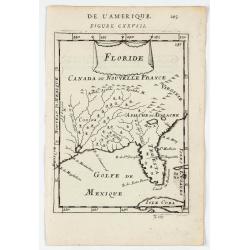
Floride.
A charming map of Florida, also showing Cuba, Golf of Mexico & St Augustine.Title in curtain draped at top. French text on verso.From the original 1683 text edition o...
Date: Paris, 1683

P.les de Virginie.
Attractive copper engraving, depicting a couple of native people of Florida.From the French text edition of Description d'Univers, 1683. by Allain Manneson Mallet (1630-1...
Date: Paris, 1683
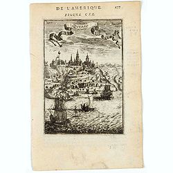
Quebec.
A charming view of Quebec. Title in curtain draped at top. French text on verso.From the original 1683 text edition of "Description d'Univers. . ." by Allain Ma...
Date: Paris, 1683
Mexique ou Nouvelle Espagne.
Attractive copper engraving, depicting Mexico with Central America.From the French text edition of Description d'Univers, 1683. by Allain Manneson Mallet (1630-1706), a w...
Date: Paris, 1683
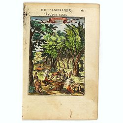
Hurons.
Attractive copper engraving, depicting Huron Indians or Wynadot / Wendat people hunting and gathering .From the French text edition of Description d'Univers, 1683. by All...
- $75 / ≈ €65
Date: Paris, 1683
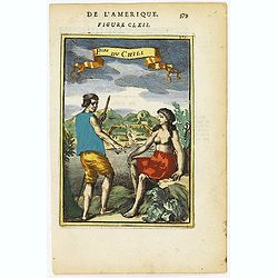
P.les du Chile.
A charming copper engraving depicting a town surrounded by a luxuriant landscape on the background and a couple of indigenous on the foreground.From the French text editi...
- $60 / ≈ €52
Date: Paris, 1683

La Floride. . .
The map is derived from La Floride , 1657, by Nicolas Sanson. Several new rivers appear in Virginia. The Caroline listed is Ft. Caroline, not the Carolinas. The Florida n...
Date: Paris, 1683

Novi Belgii novae que Angliae nec non partis Virginiae..
With the arrival of Dutch and other European colonists, the landscape of New Netherland changed dramatically. The third state, with Fort Kassimier and Philadelphia, and ...
Date: Amsterdam, 1684

Pas kaart Van Rio Oronoque Golfo De Paria met d'Eylanden Trinidad, Tabago, Granada, Granadillos, en Bequia . . .
A highly detailed and rare sea chart of the mouth of the Orinoco River, Trinidad, Tabago, St.Vincent and neighboring islands. Oriented with north to the right by two comp...
Date: Amsterdam, 1684
![Amerique Septentrionale divisée en ses principales parties. . .1685. [California as an Island]](/uploads/cache/60628-250x250.jpg)
Amerique Septentrionale divisée en ses principales parties. . .1685. [California as an Island]
Engraved by Cordier. Spectacular example of Jaillot's map of North America, showing California as an Island, based upon Sanson's landmark map of 1656. This map shows the ...
Date: Paris, 1685
L'America Meridionale . . .
The second edition of Rossi's map of South America, based upon Sanson's map, but with revised Italian nomenclature. From his 'Mercurio Geografico...'. The engraver was G...
Date: Rome, 1687

Archipelague du Mexique ou sont les Isles de Cuba..
Scarce map of Caribbean. A visually stunning map with a large title cartouche. This large one-sheet map was produced by the Venetian cosmographer Vincenzo Coronelli when ...
Date: Paris, 1688
![America Settentrionale Colle Nuove Scoperte Sin All Anno 1688. . . (together with] America meridionale . . .](/uploads/cache/49063-250x250.jpg)
America Settentrionale Colle Nuove Scoperte Sin All Anno 1688. . . (together with] America meridionale . . .
Gorgeous example of Coronelli's famous four- sheet map of America. One of the best examples of California as an island. The map also includes extensive annotations on the...
Date: Venice, 1690
![Amerique Septentrionale divisée en ses principales parties. . .1692. [California as an Island]](/uploads/cache/27961-250x250.jpg)
Amerique Septentrionale divisée en ses principales parties. . .1692. [California as an Island]
A very good impression of Jaillot's large map of North America, showing California as an Island, based upon Sanson's landmark map of 1656. A first state.The map shows the...
Date: Amsterdam, c.1692

Amerique Septentrionalis..
This handsome map shows California as an island, open-ended Great Lakes, and other details based mainly on Sanson. A large decorative cartouche occupies the area of the n...
Date: Paris, after1694
Nova Virginiae Tabula
Uncommon state of one of the most important maps of the Chesapeake Bay region, credited with disseminating knowledge of the English settlement in Virginia throughout Euro...
Date: Amsterdam, ca. 1694
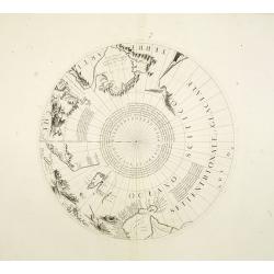
Two polar calottes from a globe.
Two polar calottes from 110 centimeters in diameter globe of 1688 including the northern part of Baffin Bay, Greenland, Iceland, Nova Zembla. Coronelli elected to follow ...
Date: Venice, 1696
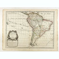
L'Amerique Meridionale Dressée sur les Observations de Mrs de l'Academie Royale des Sciences . . .
Rare state of " L’Amerique Meridionale. Chez l’Auteur sur le Quai de l’Horloge a la Courone de Diamans avec Privilege du Roy pour 20 ans, 1700".Fine map o...
Date: Paris, 1700

L'Amerique Septentrionale.
Very rare map, from "Metaphaste Barbao, Descriptio Indiae Occidentalis et America Nova" published by Henrico Verdussen.The map is a copy of Guillaume de L'Isle'...
Date: Antwerp, 1702
Insulae Americanae in Oceano Septentrionali..
A particularly handsome map portraying the south-eastern U.S., the Caribbean islands, part of Mexico, Central America, Florida (called tegesta Prov. ) and part of South A...
- $1500 / ≈ €1298
Date: Amsterdam, 1702
Carte du Mexique et de la Floride.
Third state, with "Quai de l'Horloge" imprint. Renard’s imprint has been erased”. It was the first printed map to portray accurately the course and mouth of...
Date: Paris, 1703
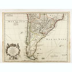
Carte du Paraguay du Chili.
A finely engraved, detailed map of the southern half of South America. Prepared by de l'Isle with the imprint "Chez l’Auteur sur le Quai de l’Horloge avec Privil...
Date: Paris, L. Renard, 1703
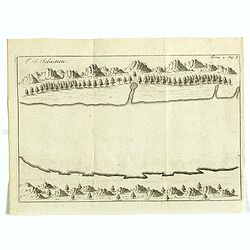
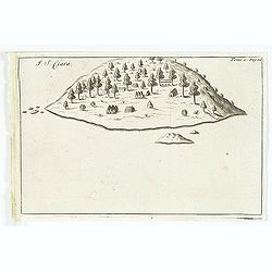
I. S. Sebastien.
Simplified bird's-eye view of Ilha de São Sebastiao, part of an archipelago off the southern coast of Brazil 210 miles from Rio de Janeiro. It was discovered on January ...
- $225 / ≈ €195
Date: Amsterdam, E. Roger, 1703
Carte du Mexique et de la Floride des Terres Angloises et des Isles Antilles...
The scarce third state with the imprint : "Chez l’Auteur sur le Quai de l’Horloge a la Cour.r de Diamãs. Avec Privilege du Roy po.r 20 ans, 1703". By 1707 ...
Date: Paris, 1703
Brasilia.
Very fine decorative map od Brazil with west to the top. From the book "A Collection of Voyages and Travels" by Churchill and the map came from the part contain...
- $550 / ≈ €476
Date: London, Printed for A. and J. Churchill, 1703
I. S. Clara.
Island "S. Clara" in Brazil just a few degrees north of the Tropic of Capricorn. From volume two of the French reissue of the account of early Dutch voyages. T...
- $150 / ≈ €130
Date: Amsterdam, E. Roger, 1703

Nieuwe gelyk Graadige Paskaart van de Kust van Guiana in West-Indien.
Detailed chart of Guiana in South America. Two scales are given in both maps: Dutch, French and English nautical miles.The inset chart provide detailed view of the Camopi...
- $650 / ≈ €563
Date: Amsterdam, 1684 - 1704
Carte du gouvernement de l'Amerique.
A double page sheet including a fine map of America, with California with indented northern coastline (130x92mm.) and New Mexico extending across most of western North Am...
- $300 / ≈ €260
Date: Amsterdam, 1705
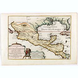
Le vieux Mexique ou nouvelle Espagne. . .
Attractive map covering the Gulf of Mexico through Central America also including parts of Cuba and Jamaica. It extends through Mexico to show the southern tip of Baja Ca...
Date: Paris, 1705
Carte du gouvernement de l'Amerique.
A double page sheet including a fine map of America, with California with indented northern coastline (130x92mm.) and New Mexico extending across most of western North Am...
- $300 / ≈ €260
Date: Amsterdam, 1705
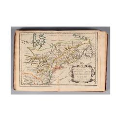
L'AMERIQUE SEPTENTRIONALE Dressée sur les Observations de Mr
One of the most influential maps of North America, laying the groundwork for much of the cartography of the 18th century. This is an early re-issue of De l'Isle's landmar...
Date: Paris, 1700 -1708
Paraguay o Prov. De Rio De La Plata cum regionibus adiacentibus Tucuman et Sta. Cruz De la Sierra.
An attractive map centered on Paraguay. Title cartouche on the upper right-hand corner, on the ocean a ship and a sea monster are depicted.
- $300 / ≈ €260
Date: Amsterdam, 1708

Pas kaart vande Zuyd kust van Cuba en van Geheel Jamaica…
A nautical chart covers the southern part of Cuba, Jamaica, the western tip of Hispaniola, and some Honduran coastline. Insets of "Baya Oristan in Yamaica ent Groodt...
Date: Amsterdam, J. van Keulen, 1697-1709
La Terre du Nord.
Map of the Arctic Circle, set within a series of decorative borders, printed from a different copper plate. All counties that lie within or near the North Pole are shown ...
Date: Amsterdam, 1713
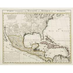
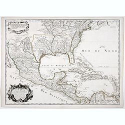
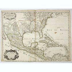
Carte contenant le Royaume du Mexique et la Floride.
This is a derivative of Delisle's landmark map of the southern part of North America. The detailed map shows many English settlements along the East Coast and carefully n...
Date: Amsterdam, 1719
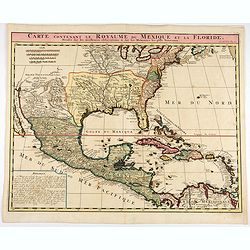
Carte contenant le Royaume du Mexique et la Floride.
This is a derivative of Delisle's landmark map of the southern part of North America.The detailed map shows many English settlements along the East Coast and carefully no...
- $1000 / ≈ €865
Date: Amsterdam, 1719
Nouvelle carte de geographie de .. Meridionale de l'Amerique
Chatelain's map of South America. The title is in two lines across the map. The tracks of Magellan, de la Maire, de Mendana, etc. are shown.On each side, borders appear a...
- $250 / ≈ €216
Date: Amsterdam, 1719