Featured Listings in Europe
![Venecie. [Venice] Foliu XLIIII](/uploads/cache/29716-250x250.jpg)
Venecie. [Venice] Foliu XLIIII
A very fine of Venice (192x525mm.) Verso a view of Padua. Schedel's view of Venice is one of the earliest obtainable views of the city. The view is based on the view of ...
Date: Nuremberg, 12 July 1493
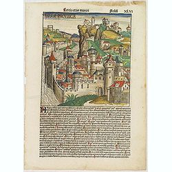
Tercia Etas Mundi. Folium.XLVI (An English town view)
Large woodcut depicting an imaginary English town (235x223mm.) and on the verso the genealogy of King David.Page from the richest illustrated Incunable, the famous: Chron...
Date: Nuremberg, 12 July 1493
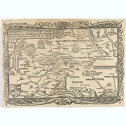
Moscovia Sigismundi Liberi Baronis In Herberstein, Neiperg et Gutehnag Anno M.D XLIX
First Modern Map of Russia. A rare and important cornerstone map for any Russian collection.One of two maps of Russia compiled by Herberstein, who was ambassador from the...
Date: Basle, 1556
![Amphitheatri Veronen[sis] diligens et accurata delineatio…](/uploads/cache/49136-250x250.jpg)
Amphitheatri Veronen[sis] diligens et accurata delineatio…
The print features the Amphitheater of Verona, it comes from "Speculum Romanae Magnificentiae" (The Mirror of Roman Magnificence). Example of the first state of...
Date: Rome, Antonio Lafreri, ca. 1560
Malita
The map includes, at the top left, a text and imprint, and, in the lower left, a scale decorated with a compass.The second state of Antonio Lafreri's map of the island of...
Date: Rome, 1565

I Europa / Das dritteil der Welt.
Very early wood cut printed map of Europe with South to the top. In the lower-left corner we see Poland, Livonia and parts of England and Ireland in the lower right corne...
Date: Zurich, Christoffel Froschover, 1548,1552-1566

( II Germania) / Tütschland.
Very early wood cut printed map of Germany, Poland, The Low Countries, Alsace and part Europe with of Switzerland, Croatia. Originally engraved in 1548. Included in "...
Date: Zurich, Christoffel Froschover, 1548,1552-1566
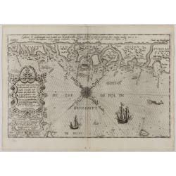
![IL GOLFO DI VENETIA [Gulf of Venice].](/uploads/cache/49393-250x250.jpg)
IL GOLFO DI VENETIA [Gulf of Venice].
IL GOLFO DI VENETI A si come è il più famose et jllustre di quanti sono dal Mare inondati, cosi dovendo uscire al mondo nelle mie stampe piu copioso di quanti fin hora so...
Date: Venice,1568

Tafel der Lender darin der Apostel Paulus geprediget hat.
Rare wood block map depicting the Mediterranean, with an over-sized Cyprus from the final Dutch edition of Heinrich Bünting's famous Itinerarium Sacrae Scripturae, a book...
Date: Magdeburg, 1581

Descrittione di M. Lodovico Guicciardini patritio Fiorentino, di tutti i Paesi Bassi,...
Second Italian edition (variant B) and first Plantin edition (1st Silvius 1567) and the most sought-after edition of the famous description of the Low Countries, updated ...
Date: Antwerp, Plantin, 1581

Universe Europae Maritime Eiusque Navigationis Descriptio. Generale Pascaerte van Europa . . .
This general chart of north-western Europe and the surrounding coastal waters is from the rare pilot-guide De Spiegel der Zeevaerdt , printed by Christopher Plantin in Le...
Date: Leyden, 1584

Belchrijuinghe vande zee custen van Engelandt. . .
A rare Dutch text edition of this detailed early chart of the northern coast of England. West to the top. The mileage cartouche has no Latin captures. Decorated by a colo...
Date: Leiden, Plantijn, 1585

Caerte der Noordt cufte van Engelandt, beginnende van Robinhodes baij tot Coket Eijlandt. . . .
A very early Dutch text edition of this detailed chart of the northern coast of England. The mileage cartouche has no Latin captures. West to the top.Decorated by a color...
Date: Leiden, Plantijn, 1585

De custen van een deel van Denemarken en Swede. . .
A detailed chart of the coast Skane and Kalmar, with the island Öland. Decorated by a title and scale cartouche, a compass rose, several vessels and sea monsters, and dep...
Date: Leiden, Plantijn, 1585
![Anverpia, nobile in Barbantia oppidum, parrim maritimum . . . [Antwerp]](/uploads/cache/26518-250x250.jpg)
Anverpia, nobile in Barbantia oppidum, parrim maritimum . . . [Antwerp]
The bird's-eye plan provides an excellent view of the citadel, city, docks and fortifications. The city was defended by a line of fortification and a moat constructed und...
Date: Cologne, 1585
De Zee-Kuste vant Landt te Noort-oosten sorterende onder Norweghen ende eendeels onder Sweden alsoe tlandt aldaer in zijn gedaente is, van Distelberch tot Waersberghe.
A rare Latin text edition of this early and detailed chart of the coast of Norway of this landmark contribution to the science of navigation. Decorated by a large title c...
Date: Leiden, Plantijn, 1585
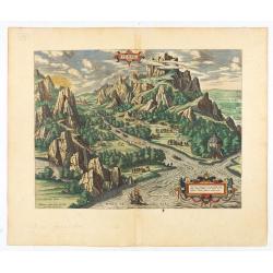
Tempe.
An attractive view of Mount Olympus and the valley in northern Thessaly (Greece), called the Vale of Tempe in ancient times, through which the river Peneus (present-day S...
Date: Antwerp, 1590

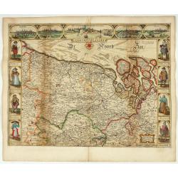
POLONIAE finitimarumque locorum descrip:tio. Auctore WENCESLAO GRODECCIO. Polono.
Ortelius' map of Poland, being a close copy of Grodecki / Pograbka's map of 1558/62 map, itself based on Wapovsky 1526 (Karrow 56) With Latin text on verso, a state 4 and...
Date: Antwerp, 1592

Lutetia Furens. Das ist : Die wütende Statt PARIS.
Rarissime placard dirigé contre la Ligue et le duc de Mayenne. La gravure est signée I.S. (marque inconnue). Ce placard en latin et en allemand est une reprise de l’estam...
Date: France ca.. 1594

Peregrinationis Divi Pauli Typus corographicus. . .
A splendid map depicting the travels of Paulus. With two fine scenes in top. Showing the countries along the Mediterranean, including Cyprus and Italy. A first edition wi...
Date: Antwerp, 1595
Selling price: ????
Please login to see price!
Sold in 2026

Latium.
Based on classical authors' sources, specifically Virgilius, Plinius, Varro, Halicarnasseus, Festus and Ausonius.Philip Wingius in his letter to Ortelius from 1592 mentio...
Date: Antwerp, 1595

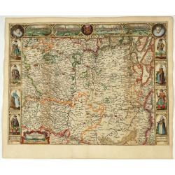
Nova et recens emendata totius Regni Ungariae una cum adiacentibus et finitimis regionisbus delineatio.
Engraved map by Jan van Deutecum, here the very rare first edition published by Cornelis Nicola in Amsterdam in 1596. In very attractive original coloring.A re-issued was...
Date: Amsterdam, Cornelius Nicol, 1596

Hollandiae Antiquorum Catthorum..
This map shows Holland in great detail, including small towns, walled cities, rivers and lakes (many of which were reclaimed in the 17th century, and no longer exist). A ...
Date: Antwerp, 1598
![Candia [Map of Crete]](/uploads/cache/45233-250x250.jpg)
Candia [Map of Crete]
1598 ROSACCIO, Giuseppe. Small map of the island Crete, published in the first edition of "Viaggio da Venetia".
Date: Venice, Giacomo Franco, 1598
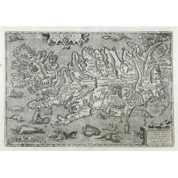
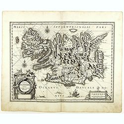
Islandia.
1603 ORTELIUS, A. - Perhaps the most famous map of Iceland. On the south side of the island, a collection of all possible sea monsters is depicted. Polar bears on ice flo...
Date: Antwerp, 1603
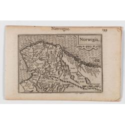
Norwegia.
An attractive and important miniature map Norway. The map is orientated to the west. The earliest map showing Norway.Prepared by Petrus Bertius, published in Amsterdam at...
Date: Amsterdam, 1606

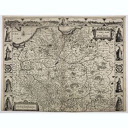
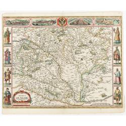
Germania.
Second state of this rare "carte à figures"- map of Germany, The Netherlands, Poland and central Europe. Bordered on three sides with portraits and views. In th...
Date: Amsterdam, 1607

(Sea-chart of Catalunia, Languedoc, Provence, Cote d'Azur, Riviera, Corsica with Marseille, Cannes, Nice, Monaco.)
This very rare chart is important as the first printed sea chart of France's Mediterranean coast, also depicting Catalunya's northern coast, the Italian Cote d'Azur till ...
Date: Amsterdam, 1607
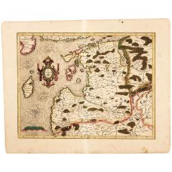
Latvia/ Estonia. Livonia.
A beautifully engraved map of Livonia – modern Latvia and Estonia – produced by two of the great fathers of modern cartography. Included are parts of the Baltic coasts of...
Date: Amsterdam, 1595-1609

Hydrograhica descriptio
This very rare chart is important as the first printed sea chart of the Mediterranean coast of Spain, Gibraltar, also depicting the northern coast of Marocco.Willem Bar...
Date: Amsterdam, W.Blaeu, 1612
Nova et accurata Foederatarum Orovinciarum Inferioris Germaniae descriptio… 1615 P.Kaerius.
The oldest know map of the Dutch Republik. The extremely rare 1615 edition of the map of the Netherlands. The map is better from from the Cloppenburg editions of the Atl...
Date: J.Janssoius, Arnhem, 1615
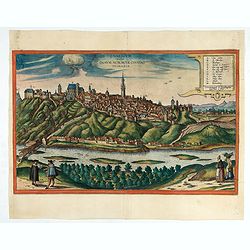
Polna vulgo Polm insign : Bohemia. . .
This is a view of Polna from the southwest, looking across the Bohemian-Moravian Highlands from a slightly elevated viewpoint. In addition to the parish church (D) in the...
Date: Cologne, 1617

Frisia occidentalis.
A rare separately published carte-a-figures of Friesland by Geelkercken in its first state. The title and the coats of arms of the eleven Frisian towns appear in the cent...
Date: [Leeuwarden], Dierick Albertsen, 1618

Deliciae Batavicae.
It is a charming book illustrated with portraits of Willem of Orange and Prince Maurits and eight engraved armorial plates. Followed by 30 engraved views or scenes of Du...
Date: Amsterdam, Johannes Janssonius, 1618
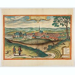
Znaymum vulgo Znaym, Moraviae Civitas Primaria.
Rare bird's-eye view of Znojmo (Znaim). A key to 12 locations.COMMENTARY BY BRAUN: "This is a beautiful and wealthy city in Moravia, situated on the border to Austri...
Date: Cologne, 1618

Angliae, Scotiae, et Hiberniae, sive Britannicar : Insularum descriptio.
A rare and ornate map with inset portraits of James First, Henry Prince of Wales Princess Anne of Denmark.Janssonius acquired the copperplate of van den Keere's 1604 Brit...
Date: Amsterdam, 1621

Typus Frisiae Orientalis à Dullarto
One of the most decorative maps of East Frisia and its important shipping center of Emden and the Watten Islands, from the cartography of Ubbo Emmius, a local cartographe...
Date: Amsterdam, ca. 1624
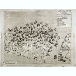
Le grand combat ov Monsieur de Montmorancy admiral de Fance . . .
Attractive view of the naval Battle of Saint-Martin de Ré, fought on 15 September 1625 between the Huguenot fleet of La Rochelle, commanded by Admiral Jean Guiton- Admira...
Date: Paris, 1625

Carte de la Coste de La Rochelle a Brouaige et de l'Isle d'Oleron Observee par le S.r de Chattillon ingenieur du Roy.
Map of the island of Oléron, with an inset in lower left corner showing the route of an English fleet to La Rochelle. At the time of mapping the area was a stronghold of ...
Date: Paris, 1627
A Newe mape of Poland Done into English by I.Speede.
A wonderful map of Poland. Incorporated into Speed's 'Prospect Of The Most Famous Parts Of The World'. Includes birds-eye views of Cracow, Dantzick, Posna, Crossen, Sando...
Date: London, 1627

A new mape of Ye XVII Provinces of Low Germanie.
Showing all 17 Provinces of the Netherlands before the split between Spain and the Protestant Provinces under the House of Orange. The map was published while the war of ...
Date: London, George Humble, 1626 [1627

Europa, ad magnae Europae Gerardi Mercatoris. . .
General map of Europe, as well as Americae Pars, Greenland, Iceland, a Polar landmass, along with the mythical islands of Frisland, Drogeo, and Bradain. A large strapwork...
Date: Amsterdam, 1628

Coloniensis Archiepisscopatus.
Extremely rare first edition of this beautiful map of Cologne and Dusseldorff.Jodocus Hondius Jr. planned to produce a new modern atlas less dependent on the Mercator pla...
Date: Amsterdam, 1629

Daniae Regni Typum..
A first state. Very decorative "carte à figures"- map of Denmark with the signature of the engraver Abraham Goos. Printed on heavy paper, in spite of its repair...
Date: Amsterdam, 1629

Nova Helvetiae Tabula.
A most decorative "carte à figures" map with panoramic views of Lucern, S.Gal, Bern, Solothurn, Schafhausen in upper border and Basel and Zurich in lower left a...
Date: Amsterdam, 1630

Romani Imperii Imago.
Very rare map in a first edition by Jacques Honervogt. Copied after a map by Ortelius, but much rarer. The medallion portraits are of Romulus and Remus - the genealogical...
Date: Paris, 1630
![Tabula electoratus Brandenburgici, Meckelenburgi, et maximae partis Pomeraniae, ex variis, famosissimisq[ue] auctoribus summo studio concinnata. . .](/uploads/cache/37545-250x250.jpg)
Tabula electoratus Brandenburgici, Meckelenburgi, et maximae partis Pomeraniae, ex variis, famosissimisq[ue] auctoribus summo studio concinnata. . .
Uncommon "carte à figures"- map engraved by the master engraver Abraham Goos and published by Claes Jansz. Visscher (1587-1652). The map shows the part of weste...
Date: Amsterdam, 1630

Palatinatus Rheni Nova et Accurata Descriptio.
Early state (1630) of Visscher's "carte à figures"- map of the German Rhine River Valley. Inset views of Frankfurt am Main, Mainz, Speyer, Worms and Heidelberg ...
Date: Amsterdam, 1630
Tabula Islandiae. . .
With a very decorative cartouche and a very fine imprint. No text on verso; included in the rare "Appendix" of 1630. VERY RARE. This handsome map of Iceland was...
Date: Amsterdam, 1630

Daniae regni typum . . .
Second Edition, now for the first time with a date (1630), this rare map which - like that of Janssonius-Kaerius - is based on John Speed's map of 1626. The side borders ...
Date: Amsterdam, 1630

Comitatus Flandria.
First published by the van Langrens c.1595, after his acquisition of the plate, Visscher heavily re-engraved the map, inserting panelled borders on three sides (the lower...
Date: Amsterdam, c. 1630

Tabula nova Poloniae et Silesiae.
Second state, dated 1630 underneath the title. A finely engraved carte á figures with cartouche representing in the four corners of the map : Kings ( on the left side Sig...
Date: Amsterdam, 1630

Belgii sive Germaniae Inferioris accuratissima tabula.
Very rare and very decorative map with in the right and left borders costumed figures and town plans alternately. In top and bottom border town plans and views.Separate p...
Date: Amsterdam, 1631

Belgium sive Inferior Germania post omnes..
Early map of the Low Countries, engraved by Abraham Goos and published for the first time in 1618. In the top border town-views of Amsterdam, Dordrecht, Antwerp, and Brus...
Date: Amsterdam, 1618/1631

Nova Germaniae Descriptio..
A finely engraved carte à figures, with the side borders depicting emperors, while the upper and lower panels contain finely engraved miniature town prospects, among them...
Date: Amsterdam, 1632

Nova et accurata Tabula Hispaniae. . .
Second state. The map shows the geographical image introduced by Hessel Gerritsz's 1612 wall map of Spain, based on information provided by the Coimbra University profess...
Date: Amsterdam, 1633

Amstelodamum, Celebre Emporium Forma Plana.
Second state of this rare and decorative plan of Amsterdam with Visscher's imprint. With a panoramic view seen from the IJ and further insets of Council House, The Exchan...
Date: Amsterdam, c. 1636

Belgium, sive Inferior Germania post omnes…
Third state (only 3 recorded copies) of this scarce map of the 17 Provinces, published by Peter Verbiest in Antwerp. West at top. The maps by Pieter van den Keere in 1607...
Date: Antwerp, 1636
Comitatus Flandria.
Second state of this scarce Carte-a-Figures of Flanders, published by Peter Verbiest in Antwerp decorated with 3 side panels without bottom border (variant of the second ...
Date: Antwerp, 1637
Brabantia Ducatus.
Second state of this scarce Carte-a-Figures map of Brabant, published by Peter Verbiest in Antwerp, decorated with three-sided panels. This is the variant without a botto...
Date: Antwerp, 1637
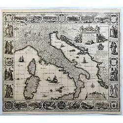
Tabulae Italiae, Corsicae, Sardiniae, et adjacentium..
A decorative map by this famous Dutch mapmaker. The border contains views of the main cities, largely inspired by the Civitates Orbis Terrarum by Braun & Hogenberg: R...
Date: Amsterdam, 1628,1640

Statt Talbe an der Saal.
Very decorative and rare panoramic town view of Calbe a.d. Saale, Bez Magdeburg.The engraver and publisher of prints, Mrs. Anna Beek of the Hague, enlarged the print and ...
Date: The Hague, ca. 1642

Czaslaw.
Very decorative and rare panoramic of Czaslaw, Caslav, Tschslau in Böhmen.The engraver and publisher of prints, Mrs. Anna Beek of the Hague, enlarged the print and mount...
Date: The Hague, ca. 1642

Wittstocs.
Very decorative and rare panoramic of Wittstock, Bez. Potsdam.The engraver and publisher of prints, Mrs. Anna Beek of the Hague, enlarged the print and mounted it on larg...
Date: The Hague, ca. 1642

Profil de la renomée ville et port d'Emstredam cappitalle des estats de Hollande.
Extremely rare panoramic town-view of Amsterdam seen from the river IJ.Exceptional bright, sharp example.The print is skillful copy of the print of Matthieu Merian, now w...
Date: Paris, 1647
Hollandia Comitatus.
1647 BLAEU,W. - The County of Holland by Holland's foremost map publisher from the Golden Age of Dutch cartography.
Date: Amsterdam, 1647

Currus Veliferi Illmi. Pr. Mauritii Nassouvii. (Prince Maurits' sailing-carriage, designed by Simon Stevin. )
Prince Maurits' sailing carriages had been designed by Simon Stevin. The Prince, always accessible to new inventions of his old instructor, could not please the foreign a...
Date: Amsterdam, 1649
![[ The repositioning of the Vatican obelisk ]](/uploads/cache/49045-250x250.jpg)
[ The repositioning of the Vatican obelisk ]
Joan Blaeu published The Repositioning of the Vatican Obelisk. This large engraving on multiple sheets and in beautiful original colors is based on Domenico Fontana’s dra...
Date: Amsterdam, 1649

Moscovia urbs Metropolis totius Russiae Albae.
Detailed bird's-eye town-plan of Moscow from Janssonius' rare townbook. With a key (1-20) to important spots in town. The verso has French text and originates from Jansso...
Date: Amsterdam, 1657

Wassende graade paskaart vertonende alle de Zeekusten van Europa, de geheele middelandsche Zee…
Wassende graade paskaart vertonende alle de Zeekusten van Europa, de geheele middelandsche Zee, als cock ten Noordwesten, en Noordoosten soo veer als ons tot noch toe bek...
Date: Amsterdam, 1658
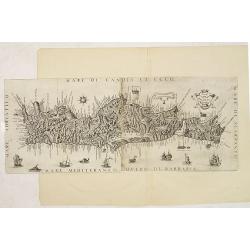
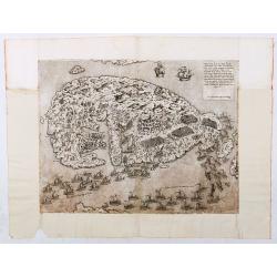
Il Regno Di Candia.
This rare map is based on the important map of Crete by Basilicata. The maps by Marco Boschini reached a wider audience than the few individuals for whom the Basilicata m...
Date: Venice, 1660

Pascaarte, van de Zuijderzee, Vliestroom, Vlie, en Amelandergat…
Very rare chart of the Dutch Zuiderzee, here in its rare 5th state (o f6). Showing the coastlines along the Dutch inner sea. Two compass roses indicate north to the left ...
Date: Amsterdam, c. 1660
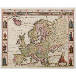
Nova Europae descriptio.
Four panels in columns on each side show portraits of the kings and Queens of European countries. The top border contains panoramas of Rome, Amsterdam, Paris, London, Sev...
Date: Amsterdam, c. 1660

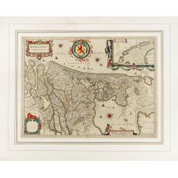
Nova XVII Provinciarum Inferioris Germaniae descriptio .
Extremely rare map of the Benelux by Frederick de Widt. Originally engraved and published by P.Kaerius in 1607. In 1662 the plate came in the possession of Frederick de W...
Date: Amsterdam, 1662

Pascaerte Van't Westelyckste der Middelandsche Zee. . .
An eye-catching chart of the western part of the Mediterranean Sea.Pieter Goos (ca. 1616-1675) was one of the most important cartographer, engraver, publisher and print s...
Date: Amsterdam, 1666

Cajanie, ou Bothnie Orientale Tirée de celles d'Andr Burae et de Isaac Massa. . .
Map of the Northern part of Gulf of Bothnia, today's border area between Sweden and Finland. The map derive from the work of the Swedish cartographer Andreas Bureus and I...
Date: Paris, P.Mariette, 1666

Pas-Caart van de Oost Zee verthooende alle de ghelegenheydt tusschen t Eylandt Rugen ende Wyborg. . .
An eye-catching chart of the Baltic Sea. Engraved by Gerard Coeck.Pieter Goos (ca. 1616-1675) was one of the most important cartographers, engravers, publishers and print...
Date: Amsterdam, 1666

Hollandiae pars septentrionalis, Vulgo Westvriesland..
Based on the work of B.F.van Berckenrode, this fine map, orientated west to the top of the sheet, includes Kennemerland and Hollands Noorderkwartier and is a reasonably u...
Date: Amsterdam, ca. 1667

EUROP, and the cheife Cities contayned therin described. . .
A good impression from an early edition of this famous and decorative "carte à figures"- map from the first world atlas produced by an Englishman - John Speed's...
Date: London, 1627 - 1676
The mape of Hungari newly augmented by John Speede.
A wonderful carte-a-figures map of ‘Hungari’, comprising modern-day Hungary and parts of Slovakia. Showing two sets of four costumed figures on each side of the map and v...
Date: Londres, Bassett and Chiswell, 1626 / 1676
