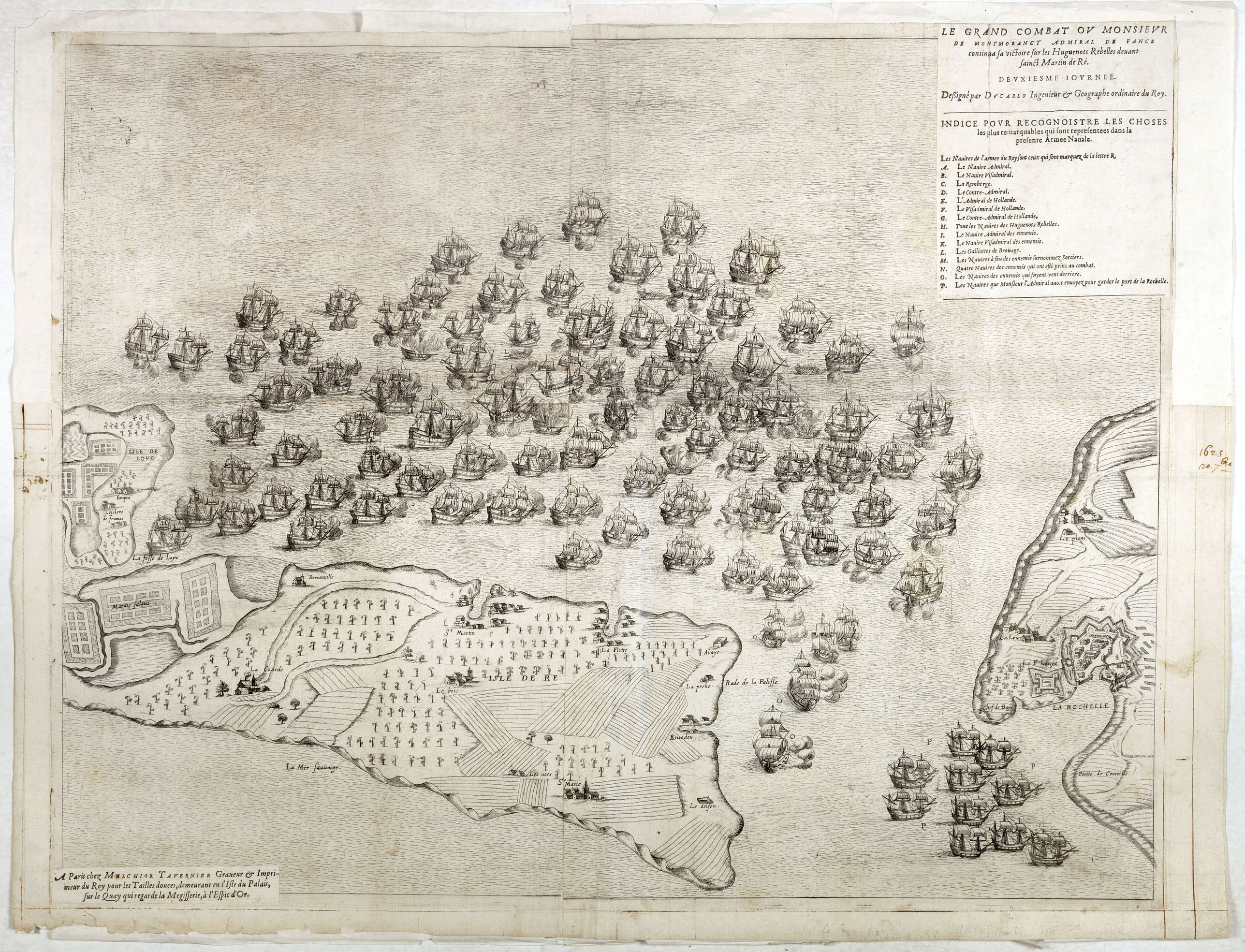
Le grand combat ov Monsieur de Montmorancy admiral de Fance . . . |
||||||||||||||||||||
|
||||||||||||||||||||
|
|
||||||||||||||||||||
$8750 / ≈ €7650This item is available for immediate sale! Questions before Buying ?
We are happy to answer your questions.
8750.00
|
My Collection +
Add this or any of your favorite items in one place. If you want to save the items permanently, you have to sign in or create an account first. |
|||||||||||||||||||
Description
Attractive view of the naval Battle of Saint-Martin de Ré, fought on 15 September 1625 between the Huguenot fleet of La Rochelle, commanded by Admiral Jean Guiton
- Admiral Benjamin de Rohan
- Duke of Soubise
and the royal French fleet, commanded by Louis XIII
- Charles de Lorraine, 4th Duke of Guise
- Henri II de Montmorency
- Admiral Willem de Zoete, Heer Haultain
resulting in a royalist victory and the re-taking of the Île de Ré by Catholic forces.
The island of Ile de Ré is at the bottom, and the town of La Rochelle is in the lower right corner. In the upper right corner, the title with a lettered key (A-P) is displayed. This view shows several of the ships of the Huguenot La Rochelle fleet, the French Catholic ships, and two of the Dutch vessels (F and G).
The Dutch participated in the siege with 20 vessels under the command of Willem de Zoete, Heer Haultain (1565 – 1637), supplied under the terms of the 1624 Franco-Dutch treaty.
The Huguenots
were members of the Protestant Reformed Church of France during the 16th and 17th centuries. The writings of John Calvin inspired French Protestants in the 1530s, and they were called Huguenots. By the end of the 17th century and into the 18th century, roughly 500,000 Huguenots had fled France.
They relocated to Protestant nations, such as the Dutch Republic. Some Huguenots fought in the Low Countries alongside the Dutch against Spain during the first years of the Dutch Revolt (1568–1609).
The ties between Huguenots and the Dutch Republic's military and political leadership, the House of Orange-Nassau, which existed since the early days of the Dutch Revolt, helped support the many early settlements of Huguenots in the Dutch Republics' colonies and even as far as Russia where Huguenot craftsmen could find customers at the court of the Czars.
The Dutch East India Company sent a few hundred to the Cape to develop the vineyards in southern Africa. About 50,000 came to England, and perhaps about 10,000 moved on to Ireland.
In February 1625, the Protestant Benjamin de Rohan, Duc de Soubise, led a Huguenot revolt against the French king Louis XIII. After publishing a manifesto, he invaded and occupied the island of Ré. He seized Ré with 300 soldiers and 100 sailors.
FAQ - Guarantee - Shipping
Buying in the BuyNow Gallery
This item is available for immediate purchase when a "Add to Cart" or "Inquire Now" button is shown.
Items are sold in the EU margin scheme
Payments are accepted in Euros or US Dollars.
Authenticity Guarantee
 We provide professional descriptions, condition report (based on 45 years experience in the map business)
Paulus Swaen warrants the authenticity of our items and a certificate of authenticity is provided for each acquired lot.
Condition and Coloring
We indicate the condition of each item and use our unnique HiBCoR grading system in which four key items determine a map's value: Historical Importance, Beauty, Condition/Coloring and Rarity.
Color Key
We offer many maps in their original black and white condition. We do not systematically color-up maps to make them more sellable to the general public or buyer.
Copper engraved or wood block maps are always hand colored. Maps were initially colored for aesthetic reasons and to improve readability. Nowadays, it is becoming a challenge to find maps in their original colors and are therefor more valuable.
We use the following color keys in our catalog:
Original colors; mean that the colors have been applied around the time the map was issued.
Original o/l colors; means the map has only the borders colored at the time of publication.
Colored; If the colors are applied recently or at the end of the 20th century.
Read more about coloring of maps [+]
Shipping fee
A flat shipping fee of $ 30 is added to each shipment by DHL within Europe and North America. This covers : International Priority shipping, Packing and Insurance (up to the invoice amount).
Shipments to Asia are $ 40 and rest of the world $50
We charge only one shipping fee when you have been successful on multiple items or when you want to combine gallery and auction purchases.
Read more about invoicing and shipping
FAQ
Please have a look for more information about buying in the BuyNow gallery
Many answers are likely to find in the general help section.
My Collection+
![]()
With My Collection+ you can collect all your favorite items in one place. It is free, and anyone can create his or her virtual collection.
Unless you are logged in, the item is only saved for this session. You have to be registed and logged-in if you want to save this item permanently to My Collection+.
Read More[+]
Register here, it is free and you do not need a credit card.
Add this item to
My Collection+
or click the following link to see My Collection+.
| Digital Image Download | |
|
Paulus Swaen maintains an archive of most of our high-resolution rare maps, prints, posters and medieval manuscript scans. We make them freely available for download and study. Read more about free image download |
Click the image for a free small image download. |
In accordance with the EU Consumer Rights Directive and habitually reside in the European Union you have the right to cancel the contract for the purchase of a lot, without giving any reason.
The cancellation period will expire 14 calendar days from the day after the date on which you or a third party (other than the carrier and indicated by you) acquires, physical possession of the lot. To exercise the right to cancel you must inform Paulus Swaen Inc, of your decision to cancel this contract by a clear statement (e.g. a letter sent by post, or e-mail.
To meet the cancellation deadline, it is sufficient for you to send your communication concerning your exercise of the right to cancel before the cancellation period has expired.
