Featured Listings
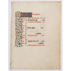
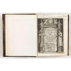
A manuscript leaf from a Book of Hours. (Calendar month of August)
RECTO : Calendar month of August with a 2-line initial in liquid gold on colored ground. colorful panel border in the left margin of acanthus leaves and flowers, with bla...
Date: Paris, ca. 1450
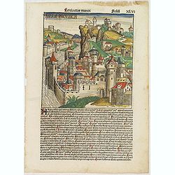
Tercia Etas Mundi. Folium.XLVI (An English town view)
Large woodcut depicting an imaginary English town (235x223mm.) and on the verso the genealogy of King David.Page from the richest illustrated Incunable, the famous: Chron...
Date: Nuremberg, 12 July 1493
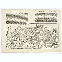
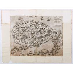
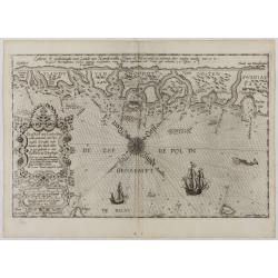
Destruccio Iherosolime.
The view shows the destruction of Jerusalem. Major points in the city are identified with Latin notations. Of interest, in the upper left of the image are two figures...
Date: Nuremberg, 12 July 1493
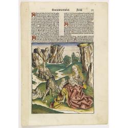
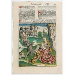
Prima Etas Mundi. IX (with Eve nursing Kain and Abel)
A very fine presentation of Eve nursing Kain and Abel. Adam is working (255x220 cm). VERSO a genealogy of Adam.Page from the richest illustrated Incunabel, the famous: Li...
Date: Nuremberg, 12 July 1493
![Venecie. [Venice] Foliu XLIIII](/uploads/cache/29716-250x250.jpg)
Venecie. [Venice] Foliu XLIIII
A very fine of Venice (192x525mm.) Verso a view of Padua. Schedel's view of Venice is one of the earliest obtainable views of the city. The view is based on the view of ...
Date: Nuremberg, 12 July 1493
Prima Etas Mundi. IX
A very fine presentation of Eve nursing Kain and Abel. Adam is working (255x220 cm). VERSO: A Genealogy of Adam.Page from the richest illustrated Incunabel, the famous Li...
Date: Nuremberg, 12 July 1493
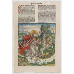
Prima Etas Mundi. VI
A very fine presentation of Eve, being created by God from Adam’s side.Page from the richest illustrated Incunable, the famous: Nuremberg Chronicle, published the year th...
Date: Nuremberg, 12 July 1493

Secunda etas mundi. Folium XIII.
SCHEDEL, H. - Nuremberg, 1493 - This world map provides a window onto the late medieval imagination, published the year that Columbus returned to Europe after discovering...
Date: Nuremberg, 12 July 1493

Quinta Asie Tabvla.
A woodblock map of ancient Median and Persian lands in modern-day Iran is from Martin Waldseemüller's 1513 edition of Ptolemy, a landmark work that contributed to major a...
Date: Strasbourg, J. Schott, 1513
![.Taprobana Ins. Tabula XII Asiae. [Sri Lanka.]](/uploads/cache/27928-250x250.jpg)
.Taprobana Ins. Tabula XII Asiae. [Sri Lanka.]
1535 - PTOLEMY, C. - The mythical island of Taprobana, which originally became associated with Sri Lanka.
Date: Lyons, M. Servetus, 1535
![.Tabula III Asiae. [Caucasus and Armenia.]](/uploads/cache/27894-250x250.jpg)
.Tabula III Asiae. [Caucasus and Armenia.]
Ptolemaic map of the region south of the Caucasus Mountains and between the Caspian Sea as far south as the headwaters of the Tigris River in the south and the Black Sea,...
Date: Lyons, M. Servetus, 1535
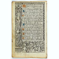
Leaf on vellum from a printed Book of Hours.
21 lines of printed text, surrounded by renaissance borders decorated with flowers, vases, religious scenes and a figure symbolizing the Danse Macabre consists of the dea...
Date: Paris, Germain Hardouyn, c.1520-1540

Tabula nova utriusque Indiae.
This is the fourth and last edition of this map based on Waldseemüller's first "modern" map of Asia. It follows that cartography without change but adds an inte...
Date: Vienne, 1541

Tabula Superioris Indiae & Tartariae maioris. (Modern Map of China, Japan, etc.)
Important map extending from Tartary in the north, to "Prov. Bocat" (Cambodia) in the south. "Tebet" is shown prominently, as is "Zinpangri"...
Date: Vienne, 1541
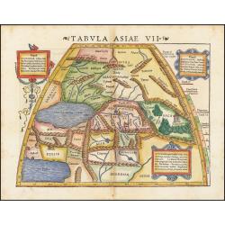
Tabula Asiae VII.
Attractive woodblock map, depicting the Caspian Sea, Black Sea and the Persian Gulf, extending to the Imaus Mountains. according to Ptolemy. In the center of the map is...
Date: Basle, 1542
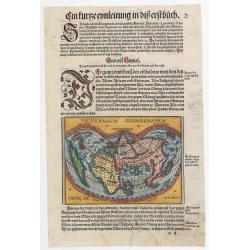
Universalis Cosmographia.
A very desirable cordiform (heart-shaped) world map from Johann Honter's 'Rudimentum'. The map is a reduced version of Waldseemüller's and Apianus' earlier world maps. Th...
Date: Zurich, Froschauer, ca. 1546/1548
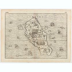
Sumatra.
Gastaldi prepared this map and it was the first separate map of any Southeast Asian island based on actual observation. The general contour of Sumatra is remarkably good ...
Date: Venice, 1556
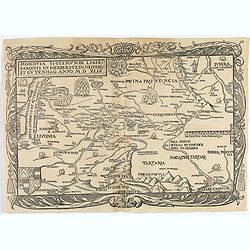
Moscovia Sigismundi Liberi Baronis In Herberstein, Neiperg et Gutehnag Anno M.D XLIX
First Modern Map of Russia. A rare and important cornerstone map for any Russian collection.One of two maps of Russia compiled by Herberstein, who was ambassador from the...
Date: Basle, 1556
![[Sea monsters] De regni Settentrionali Monstri marini & terrestri…](/uploads/cache/49169-250x250.jpg)
[Sea monsters] De regni Settentrionali Monstri marini & terrestri…
Münster's plate of monsters of both land and sea, taken from an Italian text edition of Münster's Cosmographia, which is a short and complete summary of Renaissance knowl...
Date: Basel, 1558
![Amphitheatri Veronen[sis] diligens et accurata delineatio…](/uploads/cache/49136-250x250.jpg)
Amphitheatri Veronen[sis] diligens et accurata delineatio…
The print features the Amphitheater of Verona, it comes from "Speculum Romanae Magnificentiae" (The Mirror of Roman Magnificence). Example of the first state of...
Date: Rome, Antonio Lafreri, ca. 1560

Tierra Nueva.
Uncommon first edition of this early map of the east coast is an enlarged version of Giacomo Gastaldi map published in 1548. Nomenclature and cartography are unchanged, w...
Date: Venice, 1561
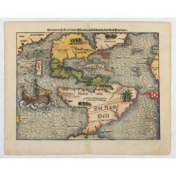
Die neüwen Inseln/ so hinder Hispanien gegen Orient bey dem land Indie ligen.
The earliest and one of the most important separate maps to show both Americas. Although it was not the first map to use “America” as a designation for the New World, it ...
Date: Basle 1561

Il Cuscho citta principale della provincia del Peru.
A very desirable and scarce item of this decorative and early bird's-eye town-plan of the Inca city of Cuzco. Several figures shown inside the city walls and on the hills...
Date: Lyons, 1564
Malita
The map includes, at the top left, a text and imprint, and, in the lower left, a scale decorated with a compass.The second state of Antonio Lafreri's map of the island of...
Date: Rome, 1565

I Europa / Das dritteil der Welt.
Very early wood cut printed map of Europe with South to the top. In the lower-left corner we see Poland, Livonia and parts of England and Ireland in the lower right corne...
Date: Zurich, Christoffel Froschover, 1548,1552-1566

( II Germania) / Tütschland.
Very early wood cut printed map of Germany, Poland, The Low Countries, Alsace and part Europe with of Switzerland, Croatia. Originally engraved in 1548. Included in "...
Date: Zurich, Christoffel Froschover, 1548,1552-1566
![IL GOLFO DI VENETIA [Gulf of Venice].](/uploads/cache/49393-250x250.jpg)
IL GOLFO DI VENETIA [Gulf of Venice].
IL GOLFO DI VENETI A si come è il più famose et jllustre di quanti sono dal Mare inondati, cosi dovendo uscire al mondo nelle mie stampe piu copioso di quanti fin hora so...
Date: Venice,1568
![[Title page for] Theatrum Orbis Terrarum.](/uploads/cache/47940-250x250.jpg)
[Title page for] Theatrum Orbis Terrarum.
A decorative title page of the first atlas ever made shows five female figures as allegorical representatives of the continents, grouped around the title. According to P...
Date: Antwerp, after 1570
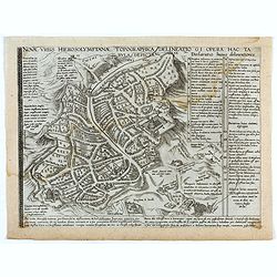
Novae Urbis Hierosolymitanae topographica delineatio . . .
A very rare plan of modern Jerusalem oriented to the east, according to a note on the map the map was drawn after a map by Peter Laicstain. A lettered key to the right.Up...
Date: Antwerp, 1571
Benedict. Arias Montanus Sacrae Geographiae Tabulam Ex Antiq
THE EXTREMELY RARE FIRST STATE landmark world map, famed for its depiction of the Australian landmass.One of the earliest printed maps to depict the “terra incognita” of...
Date: Anvers 1571 /1572
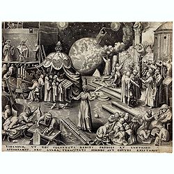
Temperance (Temperantia) from The Virtues.
Very decorative engraving by Philip Galle (Haarlem 1537–1612 Antwerp) after Pieter Bruegel the Elder (Breda (?) ca. 1525–1569 Brussels). The print was published by Hieron...
Date: Antwerp, Hieronymus Cock, 1580

Tafel der Lender darin der Apostel Paulus geprediget hat.
Rare wood block map depicting the Mediterranean, with an over-sized Cyprus from the final Dutch edition of Heinrich Bünting's famous Itinerarium Sacrae Scripturae, a book...
Date: Magdeburg, 1581

Descrittione di M. Lodovico Guicciardini patritio Fiorentino, di tutti i Paesi Bassi,...
Second Italian edition (variant B) and first Plantin edition (1st Silvius 1567) and the most sought-after edition of the famous description of the Low Countries, updated ...
Date: Antwerp, Plantin, 1581

Universe Europae Maritime Eiusque Navigationis Descriptio. Generale Pascaerte van Europa . . .
This general chart of north-western Europe and the surrounding coastal waters is from the rare pilot-guide De Spiegel der Zeevaerdt , printed by Christopher Plantin in Le...
Date: Leyden, 1584

Belchrijuinghe vande zee custen van Engelandt. . .
A rare Dutch text edition of this detailed early chart of the northern coast of England. West to the top. The mileage cartouche has no Latin captures. Decorated by a colo...
Date: Leiden, Plantijn, 1585

Caerte der Noordt cufte van Engelandt, beginnende van Robinhodes baij tot Coket Eijlandt. . . .
A very early Dutch text edition of this detailed chart of the northern coast of England. The mileage cartouche has no Latin captures. West to the top.Decorated by a color...
Date: Leiden, Plantijn, 1585

De custen van een deel van Denemarken en Swede. . .
A detailed chart of the coast Skane and Kalmar, with the island Öland. Decorated by a title and scale cartouche, a compass rose, several vessels and sea monsters, and dep...
Date: Leiden, Plantijn, 1585
De Zee-Kuste vant Landt te Noort-oosten sorterende onder Norweghen ende eendeels onder Sweden alsoe tlandt aldaer in zijn gedaente is, van Distelberch tot Waersberghe.
A rare Latin text edition of this early and detailed chart of the coast of Norway of this landmark contribution to the science of navigation. Decorated by a large title c...
Date: Leiden, Plantijn, 1585
![Anverpia, nobile in Barbantia oppidum, parrim maritimum . . . [Antwerp]](/uploads/cache/26518-250x250.jpg)
Anverpia, nobile in Barbantia oppidum, parrim maritimum . . . [Antwerp]
The bird's-eye plan provides an excellent view of the citadel, city, docks and fortifications. The city was defended by a line of fortification and a moat constructed und...
Date: Cologne, 1585

Mercurius.
Mercury holding a caduceus and riding in a chariot drawn by two birds on the clouds in the sky, an extensive landscape with a harbor with goods being loaded and unloaded ...
Date: Antwerp, 1585
Selling price: ????
Please login to see price!
Sold in 2025
![Imposita saxo Jacob cervice quiescens Aligeros scalas vidit imre choros. Gene[sis] 28](/uploads/cache/47690-250x250.jpg)
Imposita saxo Jacob cervice quiescens Aligeros scalas vidit imre choros. Gene[sis] 28
A superb example of this illustration showing a blind Isaac blessing Jacob. Copper engraving published in " Thesaurus sacrarum historiarum veteris testamenti, elegan...
Date: Antwerp, 1585

Novus de Leone Belgico eiusq topographia atq. Historica descriptione liber (…). Rerumque in Belgio maxime gestarum, inde ab anno Christi M.D.LIX. Usque ad annum M.D.LXXXVII perpetua narratione continatus.
ENLARGED EDITION, with 207 (of 208) engravings of a famous eyewitness account of the Dutch Revolt, with the famous "Leo Belgicus" map, here in its second state...
Date: Cologne, Gerardus Campensis for Frans Hogenberg, 1588
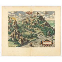
Tempe.
An attractive view of Mount Olympus and the valley in northern Thessaly (Greece), called the Vale of Tempe in ancient times, through which the river Peneus (present-day S...
Date: Antwerp, 1590

POLONIAE finitimarumque locorum descrip:tio. Auctore WENCESLAO GRODECCIO. Polono.
Ortelius' map of Poland, being a close copy of Grodecki / Pograbka's map of 1558/62 map, itself based on Wapovsky 1526 (Karrow 56) With Latin text on verso, a state 4 and...
Date: Antwerp, 1592

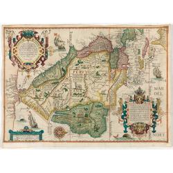
Americae Pars Magis Cognita. Chorographia nobilis & opulentae Peruanae Provinciae, atque Brasiliae, . . . MDXCII
First state. Although a map of South America it does include much of what is now the southern United States. There are two elaborate, strap-work cartouches with the one a...
Date: Frankfurt, 1592

La Florida/ Peruviae Auriferae regionis Typus/ Guastecan.
The Chaves map of Florida is a prime example of an explorer's map since it records the recent discoveries of Cabeza de Vaca, De Soto, and Moscoso. The map revealed little...
Date: Antwerp, 1592
(South America) - Delineatio omnium orarum totius Australis partis Americae, dictae Peruvianae, a R. de la Plata, Brasiliam Pariam, et Castellam auream una cum omnibus…
1593 LINSCHOTEN, J.H. van - Decorative map of South America, which goes as far north as part of Florida, is extremely well-detailed along the coast.
Date: Amsterdam, 1593

(Island of Pearls) Perlarum insula ob unionum copiam sic dicta.
A depiction of Cubagua as the Perlarum Insula (Island of Pearls), with in the foreground, two large ships send dinghies toward busy Native Americans collecting pearl oyst...
Date: Frankfurt, 1594

Lutetia Furens. Das ist : Die wütende Statt PARIS.
Rarissime placard dirigé contre la Ligue et le duc de Mayenne. La gravure est signée I.S. (marque inconnue). Ce placard en latin et en allemand est une reprise de l’estam...
Date: France ca.. 1594

Peregrinationis Divi Pauli Typus corographicus. . .
A splendid map depicting the travels of Paulus. With two fine scenes in top. Showing the countries along the Mediterranean, including Cyprus and Italy. A first edition wi...
Date: Antwerp, 1595
Selling price: ????
Please login to see price!
Sold in 2026

Latium.
Based on classical authors' sources, specifically Virgilius, Plinius, Varro, Halicarnasseus, Festus and Ausonius.Philip Wingius in his letter to Ortelius from 1592 mentio...
Date: Antwerp, 1595

Peregrinatie Jesu Christu Een ordentliche beschrijvinge des Heijligen landts....
Very rare separately map of the Holy Land engraved by Joannes van Doetecum Jr. Oriented to the east. The shoreline runs from "Antaradus" in Syria to "Rhino...
Date: Amsterdam, ca. 1595

Nova et recens emendata totius Regni Ungariae una cum adiacentibus et finitimis regionisbus delineatio.
Engraved map by Jan van Deutecum, here the very rare first edition published by Cornelis Nicola in Amsterdam in 1596. In very attractive original coloring.A re-issued was...
Date: Amsterdam, Cornelius Nicol, 1596
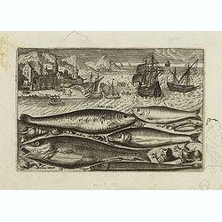
Faber piscis, Asellus minor, Conger, Alburinus. (Piscium Vivæ Icones - Fish)
Depiction of Faber piscis, Asellus minor, Conger, Alburinus. Fish set against a mountainous landscape in the manner of Pieter Brueghel the Elder. Plate number 14. The eng...
Date: Antwerp, after 1598
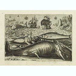
Virulus marinus. Cete (Whale and whaling scene)
Whale and whaling scene, set against a mountainous landscape in the manner of Pieter Brueghel the Elder. Plate number 1. The engraving is copied after Adrian Collaert pla...
Date: Antwerp, after 1598

Hollandiae Antiquorum Catthorum..
This map shows Holland in great detail, including small towns, walled cities, rivers and lakes (many of which were reclaimed in the 17th century, and no longer exist). A ...
Date: Antwerp, 1598
![Candia [Map of Crete]](/uploads/cache/45233-250x250.jpg)
Candia [Map of Crete]
1598 ROSACCIO, Giuseppe. Small map of the island Crete, published in the first edition of "Viaggio da Venetia".
Date: Venice, Giacomo Franco, 1598

Jerusalem.
Very rare view of Jerusalem published in the first edition of "Viaggio da Venetia, a Costantinopoli. Per Mare, e per Terra, & infieme quello di Terra Santa. Da G...
Date: Venice, Giacomo Franco, 1598

Christophorus Columus Ligur Indiarum Prim invet A°1492
Very decorative portrait of Christopher Columbus (c. 31 October 1451 – 20 May 1506), engraved by Theodor de Bry (1528-1593) and published in Jean Jacques Boissard, "...
Date: Frankfurt a.M. 1597 - 1599
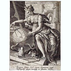
Geometria, from The Seven Liberal Arts.
A female figure with a castle on her head measures a globe with a compass; representing geometry. Engraving by Johann Sadeler I after M. de Vos.
Date: Antwerp, 1570 - 1600
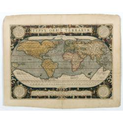
Typus Orbis Terrarum.
Ortelius' third and last world map is dated 1587 under the author's signature. The earlier border of clouds has been replaced by a more intricate and elegant lattice of s...
Date: Antwerp, 1592/1601
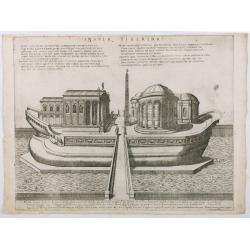
Insula Tiberina.
View of the Tiber Island depicted as a ship, showing the Temple of Aesculapius, the obelisk and other monuments. Printed by Giovanni Orlandi in1602 from a copperplate or...
Date: Rome, 1585-1602
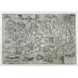
Islandia.
1603 ORTELIUS, A. - Perhaps the most famous map of Iceland. On the south side of the island, a collection of all possible sea monsters is depicted. Polar bears on ice flo...
Date: Antwerp, 1603
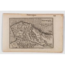
Norwegia.
An attractive and important miniature map Norway. The map is orientated to the west. The earliest map showing Norway.Prepared by Petrus Bertius, published in Amsterdam at...
Date: Amsterdam, 1606

Christophorus Clavius Bambergensis e societate iesu aetatis suae anno LXIX.
Rare portrait of Christopher Clavius or Clau (March 25, 1538 – February 12, 1612) was a German Jesuit mathematician and astronomer who was the main architect of the moder...
Date: Rome, 1606

(Sea-chart of Catalunia, Languedoc, Provence, Cote d'Azur, Riviera, Corsica with Marseille, Cannes, Nice, Monaco.)
This very rare chart is important as the first printed sea chart of France's Mediterranean coast, also depicting Catalunya's northern coast, the Italian Cote d'Azur till ...
Date: Amsterdam, 1607

Germania.
Second state of this rare "carte à figures"- map of Germany, The Netherlands, Poland and central Europe. Bordered on three sides with portraits and views. In th...
Date: Amsterdam, 1607

Polus Arcticus cum vicinis regionibus.
1608 MERCATOR, G. / HONDIUS, J. - Rare map of the North Pole, shown as a rocky island surrounded by 'in-drawing seas' between four huge islands
Date: Amsterdam, 1608

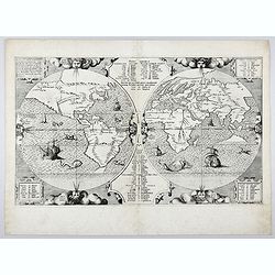
Orbis Terrae Compendiosa Descriptio.
Gerard Mercator's great world map of 1569 was condensed into double hemispherical form by his son Rumold. It first appeared in 1587 in Casaubon's edition of Strabo's Geog...
Date: Amsterdam, 1595-1609
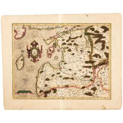
Latvia/ Estonia. Livonia.
A beautifully engraved map of Livonia – modern Latvia and Estonia – produced by two of the great fathers of modern cartography. Included are parts of the Baltic coasts of...
Date: Amsterdam, 1595-1609

Hydrograhica descriptio
This very rare chart is important as the first printed sea chart of the Mediterranean coast of Spain, Gibraltar, also depicting the northern coast of Marocco.Willem Bar...
Date: Amsterdam, W.Blaeu, 1612
Nova et accurata Foederatarum Orovinciarum Inferioris Germaniae descriptio… 1615 P.Kaerius.
The oldest know map of the Dutch Republik. The extremely rare 1615 edition of the map of the Netherlands. The map is better from from the Cloppenburg editions of the Atl...
Date: J.Janssoius, Arnhem, 1615
De Christiana expeditione apud Sinas suscepta ab Societate Jesu, ex P. Matthaei Ricci.
Very rare first edition of the most influential Western description of China since the 13th-century account by Marco Polo. Printed in Latin with an engraved title page in...
Date: Augustæ Vind. (Augsburg), C. Mangium, 1615
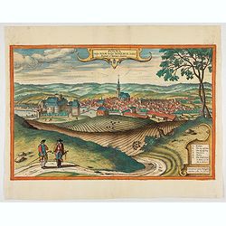
Polna vulgo Polm insign : Bohemia. . .
This is a view of Polna from the southwest, looking across the Bohemian-Moravian Highlands from a slightly elevated viewpoint. In addition to the parish church (D) in the...
Date: Cologne, 1617

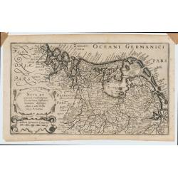
Frisia occidentalis.
A rare separately published carte-a-figures of Friesland by Geelkercken in its first state. The title and the coats of arms of the eleven Frisian towns appear in the cent...
Date: [Leeuwarden], Dierick Albertsen, 1618
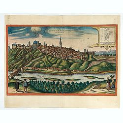
Znaymum vulgo Znaym, Moraviae Civitas Primaria.
Rare bird's-eye view of Znojmo (Znaim). A key to 12 locations.COMMENTARY BY BRAUN: "This is a beautiful and wealthy city in Moravia, situated on the border to Austri...
Date: Cologne, 1618

Deliciae Batavicae.
It is a charming book illustrated with portraits of Willem of Orange and Prince Maurits and eight engraved armorial plates. Followed by 30 engraved views or scenes of Du...
Date: Amsterdam, Johannes Janssonius, 1618

Angliae, Scotiae, et Hiberniae, sive Britannicar : Insularum descriptio.
A rare and ornate map with inset portraits of James First, Henry Prince of Wales Princess Anne of Denmark.Janssonius acquired the copperplate of van den Keere's 1604 Brit...
Date: Amsterdam, 1621
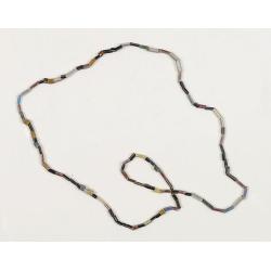
Dutch Trade Bead.
An extremely rare necklace made from authentic early 17th-century glass beads produced in the Netherlands. This rare and early Dutch Trade bead is built up from irregular...
Date: Middelburg, before 1623
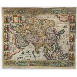
Asia recens summa cura delineata.
This is the rare early issue with decorative paneled borders of four sides. It is surrounded by elaborate borders incorporating twelve bird's eye views of cities and ten...
Date: Amsterdam, H.Hondius,1623
