Featured Listings in Asia
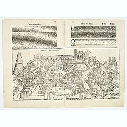
Destruccio Iherosolime.
The view shows the destruction of Jerusalem. Major points in the city are identified with Latin notations. Of interest, in the upper left of the image are two figures...
Date: Nuremberg, 12 July 1493

Quinta Asie Tabvla.
A woodblock map of ancient Median and Persian lands in modern-day Iran is from Martin Waldseemüller's 1513 edition of Ptolemy, a landmark work that contributed to major ...
Date: Strasbourg, J. Schott, 1513
![.Taprobana Ins. Tabula XII Asiae. [Sri Lanka.]](/uploads/cache/27928-250x250.jpg)
.Taprobana Ins. Tabula XII Asiae. [Sri Lanka.]
Ptolemy's mythical island of Taprobana originally became associated with Sri Lanka although it was sometimes confused with Sumatra. Taprobana, as it was called on most ea...
Date: Lyons, M. Servetus, 1535
![.Tabula III Asiae. [Caucasus and Armenia.]](/uploads/cache/27894-250x250.jpg)
.Tabula III Asiae. [Caucasus and Armenia.]
Ptolemaic map of the region south of the Caucasus Mountains and between the Caspian Sea as far south as the headwaters of the Tigris River in the south and the Black Sea,...
Date: Lyons, M. Servetus, 1535

Tabula nova utriusque Indiae.
This is the fourth and last edition of this map based on Waldseemüller's first "modern" map of Asia. It follows that cartography without change but adds an int...
Date: Vienne, 1541

Tabula Superioris Indiae & Tartariae maioris. (Modern Map of China, Japan, etc.)
Important map extending from Tartary in the north, to "Prov. Bocat" (Cambodia) in the south. "Tebet" is shown prominently, as is "Zinpangri"...
Date: Vienne, 1541
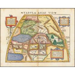
Tabula Asiae VII.
Attractive woodblock map, depicting the Caspian Sea, Black Sea and the Persian Gulf, extending to the Imaus Mountains. according to Ptolemy. In the center of the map is...
Date: Basle, 1542
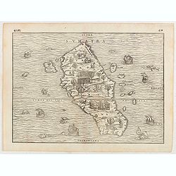
Sumatra.
Gastaldi prepared this map and it was the first separate map of any Southeast Asian island based on actual observation. The general contour of Sumatra is remarkably good ...
Date: Venice, 1556
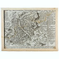
Novae Urbis Hierosolymitanae topographica delineatio . . .
A very rare plan of modern Jerusalem oriented to the east, according to a note on the map the map was drawn after a map by Peter Laicstain. A lettered key to the right.Up...
Date: Antwerp, 1571

Tafel der Lender darin der Apostel Paulus geprediget hat.
Rare wood block map depicting the Mediterranean, with an over-sized Cyprus from the final Dutch edition of Heinrich Bünting's famous Itinerarium Sacrae Scripturae, a boo...
Date: Magdeburg, 1581

Peregrinationis Divi Pauli Typus corographicus. . .
A splendid map depicting the travels of Paulus. With two fine scenes in top. Showing the countries along the Mediterranean, including Cyprus and Italy. A first edition wi...
Date: Antwerp, 1595
Selling price: ????
Please login to see price!
Sold in 2026

Peregrinatie Jesu Christu Een ordentliche beschrijvinge des Heijligen landts....
Very rare separately map of the Holy Land engraved by Joannes van Doetecum Jr. Oriented to the east. The shoreline runs from "Antaradus" in Syria to "Rhino...
Date: Amsterdam, ca. 1595

Jerusalem.
Very rare view of Jerusalem published in the first edition of "Viaggio da Venetia, a Costantinopoli. Per Mare, e per Terra, & infieme quello di Terra Santa. Da G...
Date: Venice, Giacomo Franco, 1598

De Christiana expeditione apud Sinas suscepta ab Societate Jesu, ex P. Matthaei Ricci.
Very rare first edition of the most influential Western description of China since the 13th-century account by Marco Polo. Printed in Latin with an engraved title page in...
Date: Augustæ Vind. (Augsburg), C. Mangium, 1615
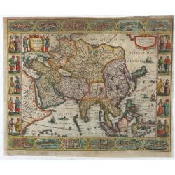
Asia recens summa cura delineata.
This is the rare early issue with decorative paneled borders of four sides. It is surrounded by elaborate borders incorporating twelve bird's eye views of cities and te...
Date: Amsterdam, H.Hondius,1623

The Kingdome of China.
A most sought-after map of China. Decorative border vignettes including views of the cities of Quinzay and Macao along the top border with the wheeled wind machines and p...
Date: London, G. Humble, 1627

Asia secunda pars in forma Pegasi.
UNRECORDED PLATE or STATE. Asia depicted as the flying horse Pegasus. Below the depiction 3 lines of engraved Latin text. Double page copper engraved map from Heinrich B�...
Date: Brunswick, ca. 1635
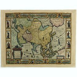
Asiae Nova Descriptio.
Final State of Pieter Van Den Keere's Rare Map of Asia--The first map of Asia to include decorative panels.The map has an interesting south positioning of the Caspian Sea...
Date: Amsterdam, 1636
Pecheli sive Peking imperii sinarum provincia prima.
The map of the province of Peking from Joan Blaeu's Novus Atlas Sinensis , the first atlas of China with maps by the hand of the Italian Jesuit Martino Martini. A beautif...
Date: Amsterdam, 1640

Peregrinations divi Pauli Tyrus Corographicus. . .
A beautifully executed and very rare map showing the peregrinations of St. Paul in the Eastern Mediterranean. The Mediterranean is ornated with two ships and two sea mons...
Date: Paris, ca. 1640

Asiae Minoris nova descriptio. Geographische Beschryvinge aller Landen... ende sendbrieuen der Apostele...
Extremely rare map from a Dutch bible, published by Dancker Danckerts. This map was included in a Dutch bible including several maps signed by C.Danckerts and one dated 1...
Date: Amsterdam, 1643

Asia carta di ciasete piu moderna. (Japan)
Rare FIRST STATE of this important map for Korea and Japan, a map of the Blancus/Moreira type, but adds a huge 'Jesso' filling the top of this old map. The map is of inte...
Date: Florence, 1646-1647
![Les Isles Philippines [on sheet with] Islas de los Ladrones ou Isle des Larrons.](/uploads/cache/42023-250x250.jpg)
Les Isles Philippines [on sheet with] Islas de los Ladrones ou Isle des Larrons.
Sanson's important mid-seventeenth-century map of the Philippines and tha Ladrones.It was first engraved by J. Somer for the elder Nicolas Sanson with a privilege for twe...
Date: Amsterdam/Utrecht, 1654

Terra Promissions.
A beautifully executed and very rare map of the Promised Land, divided into the 12 Tribes. The shore line runs in north-southwesterly direction from Sidon as far as Pelus...
Date: Paris, c.1655

Xantung, sinarum imperii provincia quatra.
A map of the northern province ‘Xantung’ of China after the Jesuit Martino Martini.Shows the Great Wall and is centered on the Bohai Sea, and the Shandong and Liaonin...
Date: Amsterdam, ca 1660
Asiae Nova Apud Hudo Allardt. / Nova et exacta Asiae geograpicha descriptio.
Rare map of Asia, with relief shown pictorially. Shows Great wall of China and the mythical island of Yedso north of Japan. Title at head of map: Nova et exacta Asiae geo...
Date: Amsterdam, 1660-1665

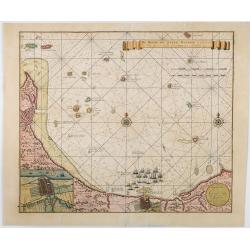
Paskaerte Zynde t'Oosterdeel Van Oost Indien, met alle de Eylanden daer ontrendt geleegen van C. Comorin tota aen Iapan.
An eye-catching chart of Pieter Goos' sea chart of Australia, Southeast Asia, China, Japan, Korea and India. The chart shows the regions from Cape Comorin (Southern India...
Date: Amsterdam, 1669

An embassy from the East-India Company of the United Provinces, to the Grand Tartar Cham, Emperor of China deliver'd by their excellencies, Peter de Goyer and Jacob de Keyzer, at his imperial city of Peking. . .
Very rare first English text edition of this most important and early resource on China and the Chinese. Three parts in one folio by John Macock for the author.Part I: An...
Date: London : Printed by the Author at his house in White-Friers, 1669
La Ville et le Château de Zélandia dans l' île de Tayovan.
This important copperplate engraving is one of the earliest European views of Taiwan, depicting the Dutch fortifications and trading settlement on the West coast of the i...
Date: Amsterdam, 1675
-250x250.jpg)
Hern Johann Baptisten Taveniers..Vierzig Jaehrige Reize..
This German edition includes Tavernier's map of Japan in a reduced form (210x315mm) and contains legends about the country's nature, e.g., where gold is mined and plottin...
Date: Nuremberg, 1681

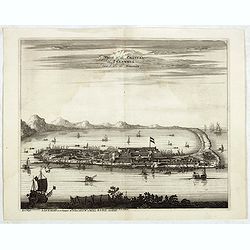
Waere affbeeldinge wegens het casteel ende stadt Batavia.
A good impression of this finely engraved and detailed plan of Batavia, present-day Jakarta, the Dutch center of trading activities in the East Indies. Copied after Cleme...
Date: Amsterdam, 1681

Il regno della China detto presentente Catay e Magnin. . .
A rare and decorative Italian map of China and Japan, with Japan closely modelled on the indented Cardim outline and Hokkaido, called Yuppi , shown as an Asian peninsula....
Date: Rome, 1682

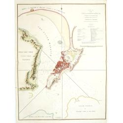
Jerusalem.
Engraved by Bastiaan Stoopendaal from Juan Bautista Villapando's imaginary town-plan of Jerusalem. This bird's-eye view is surrounded by 12 scenes, views and portraits of...
Date: Amsterdam, 1682

Paradigma XV Provinciarum et CLV Urbium Capitalium Sinensis Imperij Cum Templis quae Cruce X Signatur Et Domiciliis S.I.
First edition of this rare Jesuit map of China, published by Jean Baptiste Nolin in Paris and based on Philippe Couplet's map of 1686. The map shows China's 15 provinces ...
Date: Paris, 1686

Het gezandtschap der Neerlandtsche Oost-Indische Compagnie, aan den grooten Tartarischen Cham, Den tegenwoordigen Keizer van China. . .
Third edition of this beautifully illustrated work on China. The first edition was published in 1665.Jan Nieuhof was a "Dutch traveler and adventurer" (1618-72)...
Date: Amsterdam, W. Waasberge, 1693

Parte orientale della China.. / Parte occidentale della China. (2 sheets)
The map depicts the eastern part of China with Korea -correctly- as a peninsula. Formosa is included as well. Japan is partly visible i.e. the area of Yamaguchi, strait K...
Date: Venice, 1695

Chorographia Terrae Sanctae in Angustiorem. . .
Rare. Large visually rich map decorated with illustrations of the sacred objects and places of Judaism. In the bottom center is a plan of ancient Jerusalem, and the route...
Date: Amsterdam, ca. 1700
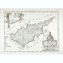
Acamantis insula hogidi Cipro . . .
Decorative map of Cyprus. The remarkable Vincenzo Coronelli (1650-1718), was a Franciscan Friar and appointed General of the Order in 1701. He was cosmographer to the Rep...
Date: Venice, 1700
![Le Royaume de Siam avec Les Royaumes Qui Luy sont Tributaries & c. / La Royaume de Siam avec les royaumes qui luy sont Tributaires, et les Isles de Sumatra, Andemaon, etc. . . [two sheet map]](/uploads/cache/40698-250x250.jpg)
Le Royaume de Siam avec Les Royaumes Qui Luy sont Tributaries & c. / La Royaume de Siam avec les royaumes qui luy sont Tributaires, et les Isles de Sumatra, Andemaon, etc. . . [two sheet map]
Influential map of Southeast Asia and the East Indies including modern day Thailand, southern Vietnam, Cambodia, Malaysia, Singapore, Borneo, Sumatra and Java. Ottens inc...
Date: Amsterdam, 1710

De Stadt Jerusalem.
Plan of ancient Jerusalem from a Dutch bible after Villalpando. The print is in contemporary colors, which is extremely rare for a plate like this. Lower left the Temple ...
Date: Amsterdam, 1710

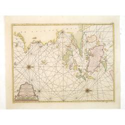
De golf van Bengalen.
Rare chart of the Indian Ocean, with nice detail on Ceylon (Sri Lanka) with compass roses and a system of rhumb lines, soundings and anchorage's. Many place names. The pl...
Date: Amsterdam, after 1669-1712

Waere Affbeeldinge Wegens het Casteel ende Stadt BATAVIA Gelegen opt Groot Eylant Java.
A good impression of this finely engraved and detailed plan of Batavia, present-day Jakarta, the Dutch center of trading activities in the East Indies. Copied after Cleme...
Date: Amsterdam, 1721
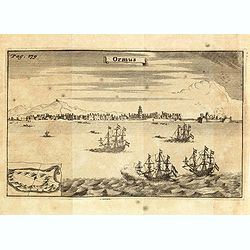
Ormus. (Hormuz)
This very interesting early engraving shows the ships of the Dutchman Van den Broecke, who in December 1628 left his directorship in Surat. Before returning to Batavia he...
Date: Amsterdam, F. Bernard, 1725

Nieuwe Kaart van het Eyland Sumatra..
Fine chart depicting the Island of Sumatra and the southern coasts of Malaysia from Quedo to Johore. North is orientated to the left of the page. Singapore is probably id...
Date: Amsterdam, 1726

Nieuwe Caart der Eylanden van Banda.
Decorative map of the Banda Islands. Until the mid-19th century the Banda Islands were the world's only source of the spices nutmeg and mace, produced from the nutmeg tre...
Date: Amsterdam, 1726

Die Insel Formosa neu abgemessen auf Befehl Kaysers Kamhi.
One of the earliest obtainable printed maps of Taiwan or Formosa Island. It was issued around 1726 to illustrate Joseph Stöcklein's [Stoecklein] compilation of Jesuit mi...
Date: Augsburg, 1726
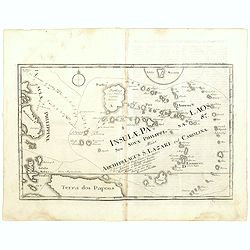
Insulae Palaos seu Novae Philippinae 87 Alias Archipelagus S. Lazari ven Carolinae . . .
Map of Philippine archipelago. Stöcklein's work is a compound of letters of the Jesuit missionaries from all over the world and here particularly the ones stationed at t...
Date: Augsburg, 1726

Great or Asiatick Tartary, Agreable to Modern History.
Map of Tartary to Peking. The eastern coastline of Asia is almost flat, with no attempt to mark Kamchatka. The Caspian Sea in the lower left, with present-day Uzbekistan...
Date: London, 1727
De Reede en stadt Batavia is geleegen aan de Noord Kust…
A chart of the bay of Batavia with in lower left corner a plan of Batavia (120x147mm). This very rare and influential chart gives a fine representation of Batavia, now kn...
Date: Amsterdam, 1728

Histoire Naturelle, Civile, Et Ecclésiastique..'
First French edition, published by P. Gosse, J. Neaulme and B. Lakeman. The basic work on Japan from the second half of the 17th century when it was still forbidden for f...
Date: Amsterdam, 1729

Insularum Moluccarum Nova description.
Exquisite map of the famous Spice Islands based. This map was the first large-scale map of the region and depicts the islands which provided first the Portuguese and then...
Date: Amsterdam, 1730

Vorstellung der Evangelisch-Ostindischen Kirche Augsburger Protestanten.
It is a very decorative and rare print to commemorate the 200-year Confession of the Augsburg Protestant Confession. Engraved by J. Kleinschmidt after a design of E. Ridi...
Date: Augsburg, 1732
Nova Maris Caspii et Regions Usbeck. . .
This is the first printed map specifically of the Uzbek region. It shows the area around the Caspian Sea and northern Iran. The area eastward from the Caspian is marked '...
Date: Nuremberg, 1735
![Province de Fo-Kien. [Includes West Coast of Taiwan]](/uploads/cache/43503-250x250.jpg)
Province de Fo-Kien. [Includes West Coast of Taiwan]
An important map of Fujian Province shows the East Coast of China and the West Coast of Taiwan. It shows that for the Manchu Qing, only the western half of Formosa was co...
Date: The Hague, H. Scheurleer, 1737

Royaume de Corée.
With a quite elaborately pictorial cartouche, engraved by G.Kondet. One of the earliest separate maps of Korea. Jean Baptiste Bourguignon d' Anville (1697-1782), French c...
Date: The Hague, 1737

Allerneuester geographisch- und topographischer Schau-Platz von Africa und Ost-Indien. . .
An early issue of this important book by Johann Wolfgang Heydt's describing the Dutch factories, settlements and stations at the hands of the Dutch East India Company in ...
Date: Wilhermsdorf, Tetscher u. Nürnberg, Homanns Erben, 1744

Nouvelle carte des mers comprises entre le détroit de Banca et P°. Timon avec la partie orientale du détroit de Malacca.
Important French chart of the tip of Malaysia with Singapore. Latitude and longitude scales, compass rose and system of rhumb lines, soundings near coast and in bay areas...
Date: Paris, 1745
![Carte de la coste orientale de la Chine depuis Amoy, jusqu'à Chusan avec une partie de l'Isle Formose [with] Plan du port d'Amoy ou Emouy.](/uploads/cache/33583-250x250.jpg)
Carte de la coste orientale de la Chine depuis Amoy, jusqu'à Chusan avec une partie de l'Isle Formose [with] Plan du port d'Amoy ou Emouy.
Important French chart of the China Sea with the coast of Northern China, including a large depiction of Formosa.Latitude and longitude scales, compass rose and system of...
Date: Paris, Jean-François Robustel, 1745
![[Set of 3 optical prints] Vue du Pallais du l'Empereur de Perse avec la Mosquée, ou Eglise a Ispahan.](/uploads/cache/49123-250x250.jpg)
[Set of 3 optical prints] Vue du Pallais du l'Empereur de Perse avec la Mosquée, ou Eglise a Ispahan.
An optical print of the court of the Persian Emperor. Engraved by F.X. Habermann (1721-1796). The Academie Imperiale was a well-known publisher of optical prints establis...
Date: Augsburg, 1750
![Kantong [The Dutch Folly Fort off Canton]](/uploads/cache/05714-250x250.jpg)
Kantong [The Dutch Folly Fort off Canton]
Charming 18th water color on paper depicting The Dutch "Folly Fort" off Canton. Probably made by a western artist visiting China.Forts were built in several pla...
Date: Canton?, c.1750
Prospectus septem turrium in urbe Constantinopolitana / Vüe des sept Tours ou Prisons d'etat à Constantinople. . .
Imaginary view inside Istanbul showing the State prison, the seven towers to Constantinople, a so-called optical print.
Date: Augsburg 1750
Paskaart van de Eijlanden Cheuxan Lowang en alle deselfs onderhoorige Eylande. . .
A rare and finely engraved and detailed chart of China's Zhejiang Province, including Ningbo, Zhoushan and Mount Putuo (Powto) and the mouth of the Yangtze Delta, just so...
Date: Amsterdam, 1753

Karte von den Kusten von Arabien . . .
Manuscript map of Arabia. A close copy of Bellin's map of the Arabian Peninsula. In the lower right margin "Tom A, vol V."A title cartouche in the lower left co...
Date: Germany, ca. 1760

Terrae Yemen Maxima Pars, seu Imperii Imami, Principatus Kaukeban nec non ditionum Haschid u Bekil, Nehhm, Chaulan, Abu Arisch et Aden Tabula ...
South-west Arabia, with the Saudi Arabian city of Jizan south to Aden. With a fine title, cartouche. Based on a map by Carsten Niebuhr. With the name Sinus Arabicus Mare ...
Date: Augsbourg, 1774

A chart of the China Sea inscribed to Monsr. D'APRES de MANNEVILLETTE .. To A.Dalrymple.
This most important milestone chart is based upon the surveys made from navigational surveys by Alexander Dalrymple (1737-1808]. He was the first hydrographer of the Brit...
Date: Paris, ca 1775
![[Lot of 4 charts] Plan de la Baie et du Port de Camraigne / Plan de la Baie de Niatrang et du Golfe de Binkang / Plan de la Cote de Cochinchine. . . / Plan des Ports de Xuandai, Vung-Lam. . .](/uploads/cache/44795A-250x250.jpg)
[Lot of 4 charts] Plan de la Baie et du Port de Camraigne / Plan de la Baie de Niatrang et du Golfe de Binkang / Plan de la Cote de Cochinchine. . . / Plan des Ports de Xuandai, Vung-Lam. . .
[A set of four French sea charts numbered consecutively]. A set of 4 basic coastal sea charts of parts of southern French Indochina (Vietnam).Chart 295 centers on the reg...
Date: Paris ca 1780
![[Manuscript] Plan du siege de la forteresse d'Oczakow avec les détails... aux ordres du Prince Potemkin, le 17 Decemb: 1788.](/uploads/cache/34599-250x250.jpg)
[Manuscript] Plan du siege de la forteresse d'Oczakow avec les détails... aux ordres du Prince Potemkin, le 17 Decemb: 1788.
Very detailed well executed manuscript plan of the Turkish Fortress Ochakov captured by Russian Troops on December 17, 1788 by the Maréchal Prince Potemkin. In lower lef...
Date: ca. 1788
![[Tableau Général de l'Empire Ottoman]. 11 plates with the panoramic view of Mecca.](/uploads/cache/41513-250x250.jpg)
[Tableau Général de l'Empire Ottoman]. 11 plates with the panoramic view of Mecca.
A collection of 11 engraved plates (3 folding) from "Tableau Général de l'Empire Ottoman", Paris, Imprimerie de Monsieur, 1790, comprising the famous panorami...
Date: Paris, 1790
![ИНДIИ [Map of India in Cyrillic].](/uploads/cache/44340-250x250.jpg)
ИНДIИ [Map of India in Cyrillic].
A map of India. This Cyrillic version of the map appeared in one of the first world atlases published in Russia, "Novy Atlas, ili sobranie kart ..." which trans...
Date: Paris / St.Petersburg, ca. 1790

Mapa De la parte de la Isla Formosa sa perteneciente al Emperadotde la China sacado por Ord. De S.M.
Extremely rare map of the west coast of Taiwan, the Punghu or Pescadore Islands, and the Fokien or Fujian coast of China. Several ancient Taiwanese cities are noted, incl...
Date: Manilla, Seminario Conciliar, y Real de San Carlos, 1788-1792
A Plan of the city and harbour of Macao : a colony of the Portugueze, situated at the southern extremity of the Chinese Empire. . .
A large chart of Macao engraved by Benjamin Baker (fl. 1766-1824) and published by George Nicol. The town of Macao is shown in detail, with a 37-point key in English list...
Date: London, 1796
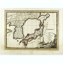
Le Isole del Giappone e la Corea delineate sulle ultima osservazioni.
First edition on laid paper. Cassini’s splendid early map of Japan and Korea, with a large decorative title cartouche. The map has a very unusual, almost triangular, re...
Date: Rome, 1797

L'Arabia delineata sulle ultime osservazioni.
First edition on laid paper. Cassini’s splendid early map of Arabia.
Date: Rome, 1797

SETTSU MEISHO ZUE. Illustrations of famous places in Settsu.
Settsu Meisho Zue was printed in two series of 8 and 4 volumes. The principal illustrator was Takehara Shunchosai, but many illustrations in the 4 volumes supplement are ...
Date: Osaka, Yanagiwara Kibei, Kansei 8-10 or 1796-1798

Reis-kaart van het Britsche gezantschap van Hang-choe-foe naar Quang-choe-foe of Kanton in China.
Uncommon map of eastern part of China, showing a journey of the English Embassy from Hangzhou (south of Shanghai) to Guangzhou (Canton). The maps is giving a wealth of in...
Date: Netherlands, c.1800
![Morokoshi Meisho Zue [Illustrated Description of Famous Sites of China].](/uploads/cache/34118-250x250.jpg)
Morokoshi Meisho Zue [Illustrated Description of Famous Sites of China].
Published in Osaka, Kawachiya Genhichiro, et al. [8 book sellers], slightly later issue but apparently in Edo period, using all the same woodblocks of original first edit...
Date: Osaka, Edo, slightly later than Bunka 3, year of the tiger - 1806
![View in the island of Cracatoa. [Rakata in the Sunda Strait]](/uploads/cache/30051-250x250.jpg)
View in the island of Cracatoa. [Rakata in the Sunda Strait]
Early view of the volcano Krakatoa (Indonesian name: Krakatau), on the Indonesian island of Rakata in the Sunda Strait, taken from "Views in the South Seas" bei...
Date: London, Boydell and Co., 1808
![Sincapour. [Singapore]](/uploads/cache/23696-250x250.jpg)
Sincapour. [Singapore]
Early view of Singapore after Pâris, engraved in aquatint by Sigismond Himely (1801-1872). The view is drawn looking up the Singapore River from South Boat Quay. It sho...
Date: Paris, Finot, 1835

Kaart van de Gaspar Straaten volgens opnemingen van J.Stolze, D.Ross, enz.
Very large and rare chart centered on the strait between Bangka's southeastern seacoast and Belitung's western shores.Short front views of the coastal relief are shown in...
Date: Amsterdam 1843

Straat Sunda en Westkust van Java.
Very large and rare chart depicting Java's western seacoast close to the Sunda Strait.Showing part of Sumatra on top and the West Java tip, today hosting the Ujung Kulon ...
Date: Amsterdam (1841)1846
