Featured Listings in Asia > Central Asia

Quinta Asie Tabvla.
A woodblock map of ancient Median and Persian lands in modern-day Iran is from Martin Waldseemüller's 1513 edition of Ptolemy, a landmark work that contributed to major a...
Date: Strasbourg, J. Schott, 1513
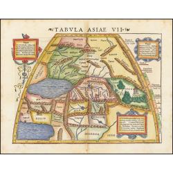
Tabula Asiae VII.
Attractive woodblock map, depicting the Caspian Sea, Black Sea and the Persian Gulf, extending to the Imaus Mountains. according to Ptolemy. In the center of the map is...
Date: Basle, 1542

Great or Asiatick Tartary, Agreable to Modern History.
Map of Tartary to Peking. The eastern coastline of Asia is almost flat, with no attempt to mark Kamchatka. The Caspian Sea in the lower left, with present-day Uzbekistan ...
Date: London, 1727
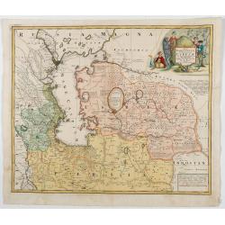
Nova Maris Caspii et Regions Usbeck. . .
This is the first printed map specifically of the Uzbek region. It shows the area around the Caspian Sea and northern Iran. The area eastward from the Caspian is marked '...
Date: Nuremberg, 1735
