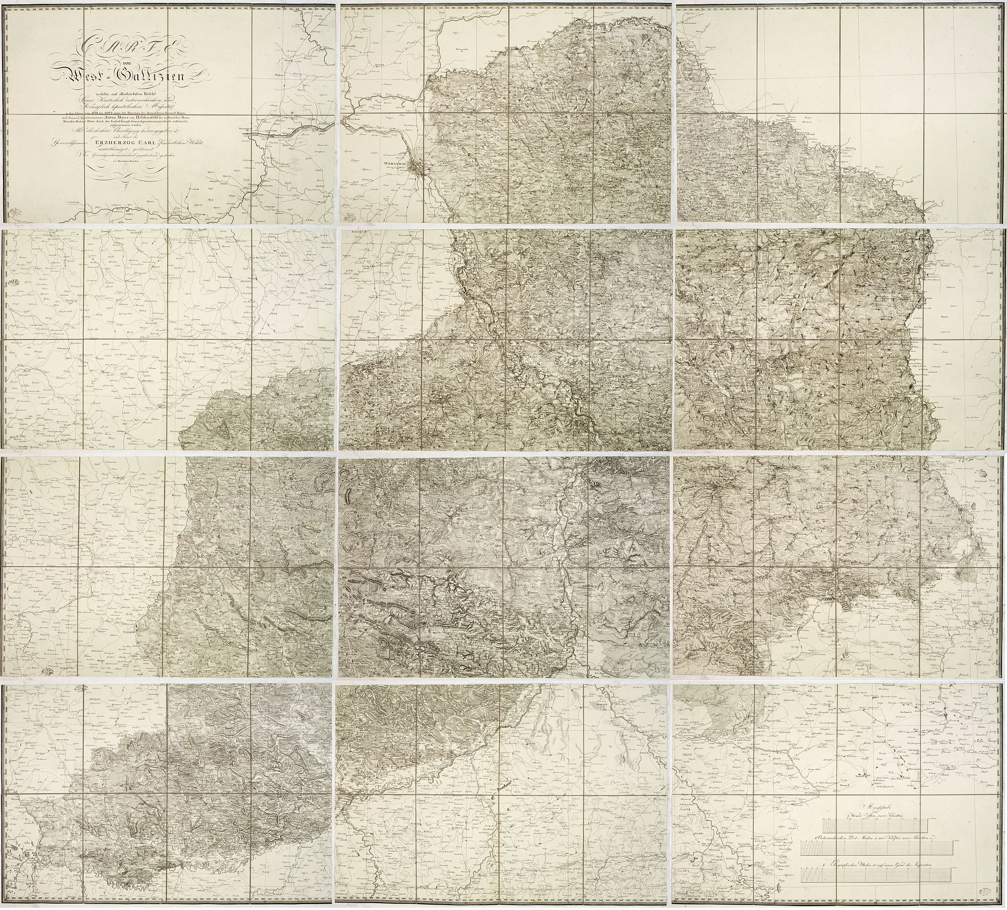
Carte von West=Gallizien welche auf allerhöchsten Befehl Seiner Kaiserlich oesterreichischen und Königlich apostolischen Majestät in den Jahren 1801 bis 1804. . . |
||||||||||||||||||||
|
||||||||||||||||||||
|
|
||||||||||||||||||||
$2500 / ≈ €2173This item is available for immediate sale! Questions before Buying ?
We are happy to answer your questions. |
My Collection +
Add this or any of your favorite items in one place. If you want to save the items permanently, you have to sign in or create an account first. |
|||||||||||||||||||
Description
Important early map of Western Galicia, as given to Austria by the third Partition of Poland (1795). Due to its lengthy development period, a rare map rich in detail depicts the areas of Warsaw, Lublin, and Kraków.
In mint condition with original slipcase.
The map is the first systematic scientific survey of the region, undertaken by the Austrian government at a time when the systematic survey of large areas was becoming a military and political imperative in Europe.
Benedicti's map is based on an Austrian Survey of the region between 1801 and 1804, conducted under the leadership of Anton Mayer von Heldensfeld (1764-1842), a military officer serving under Archduke Charles of Austria (1771-1847).
Unusual issue WITHOUT DATE: Usually, the map bears a date of 1808, and it seems the date was removed from the copper plate at publishing.
The map was, in fact, prepared between May 1808 and the Summer of 1811, such that by the time the last sheets were completed, Benedicti had died. Western Galicia was no longer a part of Austria.
West Galicia was an administrative region of the Austrian Habsburg Monarchy, constituted from the territory annexed in the course of the Third Partition of Poland in 1795. After the failed Uprising of 1794, Emperor Francis II of the Habsburg Empire and Empress Catherine II of Russia agreed to divide and thereby abolish the remaining Polish-Lithuanian Commonwealth, which Prussia joined on October 24, 1795.
Austria, which had not participated in the Second Partition, received a share that comprised the lands north of the Kingdom of Galicia and Lodomeria gained in the First Partition of 1772. Habsburg then occupied the whole of Lesser Poland, stretching along the upper Vistula river to the outskirts of Praga and Warsaw, the tributaries of the Bug and Pilica forming the northern border with New East Prussia. Source : raremaps.com
According to Dörflinger, "Bei der Veröffentlichung der Karten von Westgalizien – das durch die 3. Polnische Teilung (1795) erworbene Gebiet war zwischen 1801 und 1804 aufgenommen worden – schlug man einen anderen Weg ein: Der Kupferstich wurde‚ auf eigene aerarialische Kosten‘ durchgeführt, und nur der Druck sowie der Vertrieb (inklusive Werbung) des Werkes dem Freiherrn von Liechtenstern übertragen… hingegen wurde jedes Exemplar von einem‚ kontrollierenden Herrn Officier' mit einem Stempel des Generalquartiermeister-Stabes versehen.
Entgegen der Ankündigung vom Frühjahr 1808, daß die Karte‚ unfehlbar binnen 9 Monaten vollendet seyn‘ werde, zog sich die Herausgabe der zwölfblättrigen Carte von West=Gallizien … - vermutlich wegen des Anfang Januar 1809 erfolgten Todes des Kupferstechers Hieronimus Benedicti – von Mai 1808 bis Sommer 1811 hin, so daß die letzten Sektionen erst zu einem Zeitpunkt erschienen, als Westgalizien bereits seit mehr als eineinhalb Jahren nicht mehr zu Österreich gehörte".
Reference: Dörflinger, Österreichische Karten des frühen 19. Jahrhunderts, p 750/1.
FAQ - Guarantee - Shipping
Buying in the BuyNow Gallery
This item is available for immediate purchase when a "Add to Cart" or "Inquire Now" button is shown.
Items are sold in the EU margin scheme
Payments are accepted in Euros or US Dollars.
Authenticity Guarantee
 We provide professional descriptions, condition report (based on 45 years experience in the map business)
Paulus Swaen warrants the authenticity of our items and a certificate of authenticity is provided for each acquired lot.
Condition and Coloring
We indicate the condition of each item and use our unnique HiBCoR grading system in which four key items determine a map's value: Historical Importance, Beauty, Condition/Coloring and Rarity.
Color Key
We offer many maps in their original black and white condition. We do not systematically color-up maps to make them more sellable to the general public or buyer.
Copper engraved or wood block maps are always hand colored. Maps were initially colored for aesthetic reasons and to improve readability. Nowadays, it is becoming a challenge to find maps in their original colors and are therefor more valuable.
We use the following color keys in our catalog:
Original colors; mean that the colors have been applied around the time the map was issued.
Original o/l colors; means the map has only the borders colored at the time of publication.
Colored; If the colors are applied recently or at the end of the 20th century.
Read more about coloring of maps [+]
Shipping fee
A flat shipping fee of $ 30 is added to each shipment by DHL within Europe and North America. This covers : International Priority shipping, Packing and Insurance (up to the invoice amount).
Shipments to Asia are $ 40 and rest of the world $50
We charge only one shipping fee when you have been successful on multiple items or when you want to combine gallery and auction purchases.
Read more about invoicing and shipping
FAQ
Please have a look for more information about buying in the BuyNow gallery
Many answers are likely to find in the general help section.
My Collection+
![]()
With My Collection+ you can collect all your favorite items in one place. It is free, and anyone can create his or her virtual collection.
Unless you are logged in, the item is only saved for this session. You have to be registed and logged-in if you want to save this item permanently to My Collection+.
Read More[+]
Register here, it is free and you do not need a credit card.
Add this item to
My Collection+
or click the following link to see My Collection+.
| Digital Image Download | |
|
Paulus Swaen maintains an archive of most of our high-resolution rare maps, prints, posters and medieval manuscript scans. We make them freely available for download and study. Read more about free image download |
Click the image for a free small image download. |
In accordance with the EU Consumer Rights Directive and habitually reside in the European Union you have the right to cancel the contract for the purchase of a lot, without giving any reason.
The cancellation period will expire 14 calendar days from the day after the date on which you or a third party (other than the carrier and indicated by you) acquires, physical possession of the lot. To exercise the right to cancel you must inform Paulus Swaen Inc, of your decision to cancel this contract by a clear statement (e.g. a letter sent by post, or e-mail.
To meet the cancellation deadline, it is sufficient for you to send your communication concerning your exercise of the right to cancel before the cancellation period has expired.
Recently Viewed

Carte von West=Gallizien welche auf allerhöchsten Befehl Seiner Kaiserlich oesterreichischen und Königlich apostolischen Majestät in den Jahren 1801 bis 1804. . .
Important early map of Western Galicia, as given to Austria by the third Partition of Poland (1795). Due to its lengthy development period, a rare map rich in detail depi...
Date: Vienna, (1808) after 1811
