Popular Listings
![Voyage et conduite d'un moribond pour l'autre monde [Caricature Parisienne.]](/uploads/cache/46786-250x250.jpg)
Voyage et conduite d'un moribond pour l'autre monde [Caricature Parisienne.]
A 'busy', but sobering print depicting the procession of a dying old man to the afterlife. Attractively colored. Accompanying the old man on his inevitable journey are a ...
Date: Paris, 1820
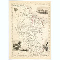
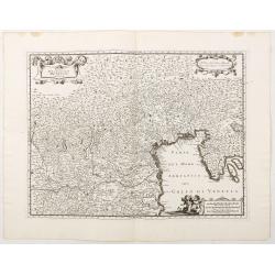
British Guayana.
A decorative steel engraved map of British Guyana. The last Tallis map of the region, published circa 1858 by The London Printing and Publishing Company (the partnership ...
Date: London, 1858
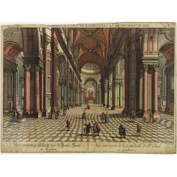
Vue interiere de la Cathedrale de St.Paul a Londres.
So-called optical print, engraved by F.Leizelt. In the eighteenth and nineteenth centuries there were many popular speciality establishments in Paris, Augsburg and London...
Date: Augsburg 1780
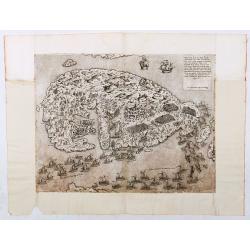
Malita
The map includes, at the top left, a text and imprint, and, in the lower left, a scale decorated with a compass.The second state of Antonio Lafreri's map of the island of...
Date: Rome, 1565
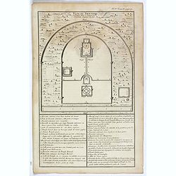
Plan du Tien-tang ou du temple, où l'empereur sacrifie à Chang-ti sous le titre de souverain seigneur de la terre.
Nice example of d'Anville's plan of Tien-tang temple, from "Atlas général de la Chine..."" prepared by Jesuit missionaries and commissioned by Emperor Kang...
Date: Paris, P.G. Le Mercier, 1735
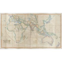
The Pathways of Empire Delineated: Map Showing The Steam Comunication And Overland Routes between England, India, China & Australia…
An illuminating and attractive map that illustrates one of the foundations of British imperial power--the key trade routes by both land and sea between England and its fa...
Date: London, 1856
![[12 volumes] Recueil des voyages qui ont servi à l'établissement et aux progrez de la Compagnie des Indes Orientales, forméedans les Provinces-Unies des Païs-Bas...](/uploads/cache/43700-250x250.jpg)
[12 volumes] Recueil des voyages qui ont servi à l'établissement et aux progrez de la Compagnie des Indes Orientales, forméedans les Provinces-Unies des Païs-Bas...
An important, richly illustrated compendium of the first Dutch voyages to East India, of great interest for the history and establishment of the Dutch global trade, parti...
Date: Rouen, Pierre Le Boucher, 1725

Carta terza Generale del' Asia.
Rare first state of this important chart showing part of the north coast of New Guinea and islands of the Pacific Ocean. To the north of Japan the landmass of Isola di Ie...
Date: Florence, 1646
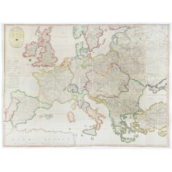
Nova Europae descriptio.
Rare early issue of the map of Europe with the lower border removed and without text on the reverse. Variant: The map no longer has a lower border, no text on the reverse...
Date: Amsterdam, after 1630
![IL GOLFO DI VENETIA [Gulf of Venice].](/uploads/cache/49393-250x250.jpg)
IL GOLFO DI VENETIA [Gulf of Venice].
IL GOLFO DI VENETI A si come è il più famose et jllustre di quanti sono dal Mare inondati, cosi dovendo uscire al mondo nelle mie stampe piu copioso di quanti fin hora so...
Date: Venice,1568
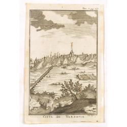
Citta di Varsavia.
Fine city view engraving of Warsaw, Poland by Thomas Salmon. Published in Rome by Giambattista Albrizzi in 1740. Giambattita Albrizzi was a famous Venetian publisher and ...
Date: Venice, 1740-1756
![Venecie. [Venice] Foliu XLIIII.](/uploads/cache/49420-250x250.jpg)
Venecie. [Venice] Foliu XLIIII.
A very fine panoramic view of Venice (192x525mm.) Verso a view of Padua. Schedel's view of Venice is one of the earliest obtainable views of the city. The view is based o...
Date: Nuremberg, 12 July 1493
![[Figura del Mondo universale].](/uploads/cache/48963-250x250.jpg)
[Figura del Mondo universale].
Münster's map of the World is one of the most recognized world maps of the 16th Century. Italian text edition published in Cologne without the title. This example is from...
Date: Arnold Birckmann heirs, Cologne, 1575
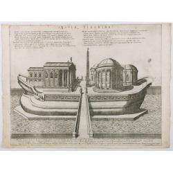
Insula Tiberina.
View of the Tiber Island depicted as a ship, showing the Temple of Aesculapius, the obelisk and other monuments. Printed by Giovanni Orlandi in1602 from a copperplate or...
Date: Rome, 1585-1602
(Post Roads of Europe) Neueste Allgemeine Postkarte von Europa in welcher samtliche Postrouten aller europaischen Staaten nach den zuverlässigsten Postbüchern. . .
The largest postal map of Europe, published in Vienna in the midst of the Napoleonic Wars. This postal map of Europe first appeared in 1798 and is considered one of the e...
Date: Vienna, 1807
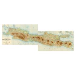
Overzichtskaart van Java en Madoera schaal 1:500.000. Met aanduiding van de politieke indeeling, de organisatie van het bestuur, de bestaande en nog aan te leggen verkeerswegen en van de groote cultuur- en industrieele centra…
If assembled a very large color-printed map (60x 218cm.) of Java and Madoera (Madura Island) on four sheets, each measuring 60 x 54.5 cm, dissected into 12 sections and l...
Date: Atelier Kurkdjian-Soerabaia, 1912
![[6 Post cards of young woman seated on a globe ]](/uploads/cache/41502-250x250.jpg)
[6 Post cards of young woman seated on a globe ]
Complete set of 6 pictorial post cards showing young women seated on a globe. Signed "Morin". Unsent.More aboutcartographical curiosities [+]
Date: Italy, ca. 1920

Illustrated map of Taiwan for tourist.
illustrated map of Taiwan for tourist. Pictorial map of Formosa published by Mei Kuang Art Company. Printed in English and Chinese. Features remarkable sites, various agr...
Date: Mei Kuang Art Company, 1954
![Hindostan [India]](/uploads/cache/49208-250x250.jpg)
Hindostan [India]
A fine copper engraved map of Hindoostan (now India) drawn and engraved by Alexander Findlay and published by Thomas Kelly, London in 1814
Date: London, 1814

Introduction a la Geographie
Engraved title, with 91 double-page engraved maps mostly including European nations, but including World and continents, Turkey, the Holy Land, Persia, China, Japan, Egyp...
Date: Paris, 1756
![[Naval battle].](/uploads/cache/49259-250x250.jpg)
[Naval battle].
The engraving was printed by Giovanni Orlandi in1602 from a copperplate originally engraved for the "Speculum Romanae Magnificentiae", with the imprints of Duc...
Date: Rome, 1585-1602
![[Lower half] Amerique Septentrionale avec les Routes, Distances en miles, Limites et Etablissements François et Anglois Par le Docteur Mitchel Traduit de 'Anglois..](/uploads/cache/49378-250x250.jpg)
[Lower half] Amerique Septentrionale avec les Routes, Distances en miles, Limites et Etablissements François et Anglois Par le Docteur Mitchel Traduit de 'Anglois..
This is the important 1777 French edition by Georges Le Rouge of the seminal John Mitchell map of eastern North America. The Mitchell map is considered the single most im...
Date: Paris, 1777
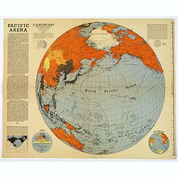
Pacific Arena
1942 FORTUNE MAGAZINE. - Second World War map covering the Pacific regions. Printed as Supplements to 'Fortune' in March 1942
Date: New York, 1942
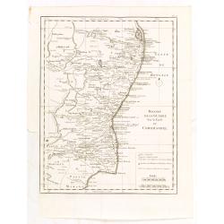
Theatre de la guerre sur la coste de Coromandel.
Map of Coromandel coast prepared by J.N.Bellin.
Date: Amsterdam, Leipzig, 1763

Karte vom Koenigreiche Ungarn mit Einschluss der Königreiche Kroazien und Slavonien dann von dem Grossfürstenthume Siebenbürgen.
Wall map of the Kingdom of Hungary in 8 sheets mounted on canvas, preserved in their original case. The map has a graduated margin and is enclosed in a simple yet decorat...
Date: Vienna, 1809

The Situation in the Far East. (時局圖)
An unusual rendering of Tse's "Situation in the Far East". Tse Tsan-tai (1872-1939), a Chinese patriot, drew the original political cartoon in Hong Kong in 1899...
Date: China, n.d. but ca. 1980/1990

Leaf on vellum from a Missal.
A very fine Missal leaf, written in Latin. RECTO: A wonderful initial P decorated with pen work in red, purple and blue. The initial is 6x6cm. VERSO: 18 lines written in ...
Date: France, c. 1410

Silesiae typus..
Fine and early map of Silesia after Martin Helwig (1516-1574) and used by A.Ortelius in his atlas 'Theatrum Orbis Terrarum [Atlas of the Whole World].Only included in the...
Date: Antwerp, 1598

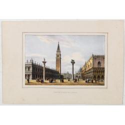
La Place de Saint Marc a Venise.
A very attractive Town plan of the place St Marc in Venice.Joan Blaeu published during his life three town books of Italy: Citta del Vaticano, Rome, and Napoli. By the ye...
Date: Amsterdam, 1705
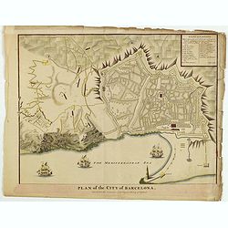
Plan of the City of Barcelona.
From Rapin's History of England , a nicely detailed plan of Barcelona, the capital of Catalonia. The plate contains a 19 point legend and the presentation is enhanced wit...
Date: London, c.1745

Secours à donner aux noyés.
Broad sheet etchings with two vignettes and extensive descriptive text about how to rescue a flooded person.Composed by François Chaussier and etched by L. Baltard. Fran...
Date: Paris, ca. 1825
![America Settentrionale Colle Nuove Scoperte Sin All Anno 1688. . . (together with] America meridionale . . .](/uploads/cache/49063-250x250.jpg)
America Settentrionale Colle Nuove Scoperte Sin All Anno 1688. . . (together with] America meridionale . . .
Gorgeous example of Coronelli's famous four- sheet map of America. One of the best examples of California as an island. The map also includes extensive annotations on the...
Date: Venice, 1690

Americae Nova Descriptio.
Final state. According to Philip Burden, "this scarce map is America's first single-sheet map with decorative borders." A re-issue of the 1614 plate by Pieter v...
Date: Amsterdam, 1652
![[Asia].](/uploads/cache/46172-250x250.jpg)
[Asia].
A detailed map from Учебный Географический Атлас published by the very successful St. Petersburg publisher "Cartographic institution A.Ilina" ("Картографич...
Date: St. Petersburg, 1899
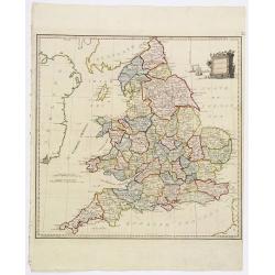
Present Britain.
A fully colored map of England and Wales from An Universal Atlas Consisting of a Complete Set of Maps, peculiarly adapted to illustrate and explain ancient and modern geo...
Date: London, 1797

II Regno di Francia Diviso in Provincie e Governi ove su`Le Frontiere di esso Rappresenta il Teatro della Guerre di Flandria Germania Savoja e Lombardia.
Very rare wall map of France depicting "The Kingdom of France divided into Provinces and Governments with on its borders the Theater of War of Flanders, Germany, Sav...
Date: Naples, 1704
Orvis veteribus novi tabula nova. . .
Scarce map of the Ancient world, prepared by Nolin and published by L.J. Mondhare for his Atlas Général a l'usage des colleges et maisons d'education.. Louis Joseph Mondh...
Date: Paris, 1781
Pagus Helvetiae Abbatiscellanus .. Valle Rhenana. . .
Scarce. A splendid map of the Swiss Alps, the area south west of the Boden See and west of the River Rhine, centered on Appenzell, St. Gallen. Engraved by Tobias C. Lotte...
Date: Augsbourg, 1760

Schlavoniae, Croatiae, Carniale.. Bosniae. . .
First state. Fine and early map of former Yugoslavia after a map of Hirschvogel (1552-1565) and used by A.Ortelius in his atlas 'Theatrum Orbis Terrarum [Atlas of the Who...
Date: Antwerp, 1579
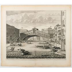
Veue du Pont de Rialto de Venise.
Spectaculair view of Rialto bridge in Venice. Joan Blaeu published during his life three town-books of Italy: Citta del Vaticano, Roma and Napoli. By the year 1672 a fire...
Date: Amsterdam, 1705
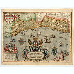
Serenissimae Reipublicae Genuensis Ducatus et Dominii.
Includes the coast of the Riviera from Nice to La Spezia. A most decorative and rare map because it was only included in the Vrients' editions of the Ortelius Theatrum . ...
Date: Antwerp, 1609-1641
Petite Place de S. Marc.
View of St Mark’s Square, lithographed in Venice by G. Brizeghel, published here with French captions in "Album delle principali vedute di Venezia". In origina...
Date: Venice, c.1855

World Flight Routes (all in Japanese).
A large, very decorative Japanese world map published as sugoroku (a Japanese game which might be compared to backgammon), published as a supplement to the 1930 New Year’...
Date: Osaka, 1930
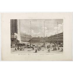
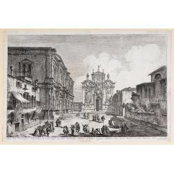
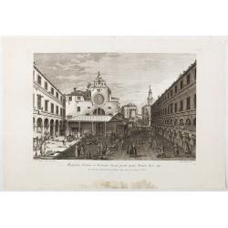
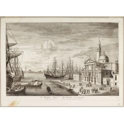
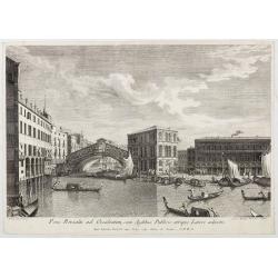
Qua late patet S. Marci area major novum Regim Palatium versus.
Qua late patet S. Marci area major novum Regim Palatium versus". View of piazza San Marco, the church of San Geminiano at the far end, figures and market stalls in t...
Date: Venice, 1763
Aedis Divi Rocchi facies rudis…
The Campo San Rocco. Title centred in the lower margin; “Mich. Marieschi del.t et inci.t” at the right corner of the cartouche. From the series "Magnificentiores Sel...
Date: Venice, c. 1742
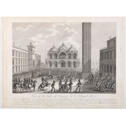
Prise de la ville de Venise le 3 floréal an 5.
Capture of the City of Venice on 3 Floréal, Year V", engraved by Pierre-Adrien Le Beau after Thomas-Charles Naudet. Deposited at the Bibliothèque nationale.During th...
Date: Paris, chez Jean, c. 1798
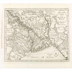
Nouvelle carte du royaume de Bengale.
Map of Bengal Kingdom prepared by J.N.Bellin.
Date: Amsterdam, Leipzig, 1763

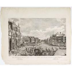
Prospectus Plateae ad Divum Iacobum de Rivoalto ubi Mercatores conveniunt.
Prospectus Plateae ad Divum Iacobum de Rivoalto ubi Mercatores conveniunt. From the series "Prospectum Urbis Venetiarum" (Views of Venice). Published by Lodovic...
Date: Venice, c. 1763
Pars Canalis Magni De Extendens A Laeva…
The Cannaregio on the Grand Canal, with the Ghetto in the background, seen from the Riva di Biasio. From the series "Magnificentiores Selectioresque Urbis Venetiarum...
Date: Venice, after 1757
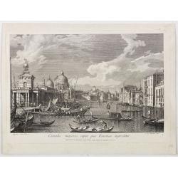
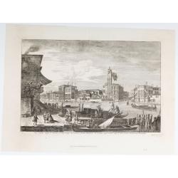
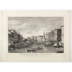
Canalis majoris caput qua Venetias ingreditur.
Canalis majoris caput qua Venetias ingreditur". A view of the Grand Canal with Santa Maria della Salute to the left after Canaletto.From the series of 12 views entit...
Date: Venice, c. 1766
Veduta della Magnifica REGATA seguita in Venezia li 2. Aprile 1791 alla quale intervennero li Augusti Viaggiator.
Decorative engraving of a Venice regatta on the Grand Canal, by Teodoro Viero (1740-1819) after a paining by Canaletto.The tradition of Venetian origin of the race is lin...
Date: Venice, c. 1791
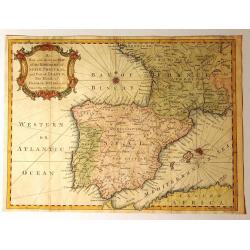
A New and Accurate Map of the Kingdoms of Spain, Portugal and Part of France, The Islands of Majorca, Minorca &c.
Produced for “Universal Magazine” by J. Hinton. It was engraved by Richard William Seale (1703-1762). The map features an attractive rococo cartouche and compass rose wi...
Date: London, ca. 1760
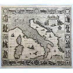
Tabulae Italiae, Corsicae, Sardiniae, et adjacentium..
A decorative map by this famous Dutch mapmaker. The border contains views of the main cities, largely inspired by the Civitates Orbis Terrarum by Braun & Hogenberg: R...
Date: Amsterdam, 1628,1640
Estat De La Seigneurie De Venize en Italie.
Map of The Venetian Dominion inspired by the map of Jodocus Hondius. Published "A Paris Chez Pierre Marietti (sic), Rue Sainct Jacques A l'esperance". Decorated...
Date: Paris, ca. 1670

Christophorus Clavius Bambergensis e societate iesu aetatis suae anno LXIX.
Rare portrait of Christopher Clavius or Clau (March 25, 1538 – February 12, 1612) was a German Jesuit mathematician and astronomer who was the main architect of the moder...
Date: Rome, 1606
![Palatii farnesii Romae… duarum Herculis statuarum icones [Farnese Palace Interior].](/uploads/cache/49258-250x250.jpg)
Palatii farnesii Romae… duarum Herculis statuarum icones [Farnese Palace Interior].
The print, depicting the interior of the Palazzo Farnese in Rome, was printed by Giovanni Orlandi in1602 from a copperplate originally engraved for the "Speculum Ro...
Date: Rome, 1585-1602
![[Lot of 6 leaves] Civitas Augustana olim Vindelica…/Sueviae et Bavariae Descriptio/ Franckfordiae ad Oderam imago…/Franckofordianae civitatis…/Erdfordia magnifica …Thuringoru urbs…Fuldensis civitatis… / Lubecum una ex praeclarioribus. . .](/uploads/cache/48258-250x250.jpg)
[Lot of 6 leaves] Civitas Augustana olim Vindelica…/Sueviae et Bavariae Descriptio/ Franckfordiae ad Oderam imago…/Franckofordianae civitatis…/Erdfordia magnifica …Thuringoru urbs…Fuldensis civitatis… / Lubecum una ex praeclarioribus. . .
1522 MÜNSTER, S. - Six text leaves with wood block printed views and maps of Augsburg, Frankfurt /Oder, Frankfurt am Main, Erfurt and Fulda, Lübeck and a map of Swabia a...
Date: Basel, 1552
![Carte de L'Amerique… / Carte Nouvelle de L'Europe Asie & Afrique… [Two sheets]](/uploads/cache/49267-250x250.jpg)
Carte de L'Amerique… / Carte Nouvelle de L'Europe Asie & Afrique… [Two sheets]
Rare. Two hemispheres printed on two sheets. A single decorative cartouche on each carries the title concluding with the imprint recorded above, and around each hemispher...
Date: Paris, 1661
Prospectus Plateae et Ecclesiae Sancti Jacobi prope Pontem Rivi alti.
Prospectus Plateae et Ecclesiae Sancti Jacobi prope Pontem Rivi alti". The Church of San Giacomo di Rialto, at right Palazzo dei Dieci and the bridge of Rialto.From ...
Date: Venice, c. 1763
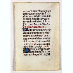
Leaf on vellum from a manuscript Book of Hours.
Leaf from a mid 15 th. century manuscript Book of Hours. Written on vellum in neat Gothic book hand.VERSO: 17 lines of text, with 2-line capital in red and blue, heighten...
Date: France ca.1470
Basilique S. Marc.
St Mark’s Basilica, lithographed in Venice by G. Brizeghel, published here with French captions in "Album delle principali vedute di Venezia". In original colo...
Date: Venice, c.1855
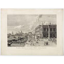
A publica Bibliotheca ad majoris Canalis initium prospectus.
A publica Bibliotheca ad majoris Canalis initium prospectus". View of the Biblioteca Nazionale Marciana, the column of San Teodoro at right, at left the Grand Canal,...
Date: Venice, 1763
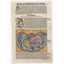
Universalis Cosmographia.
A very desirable cordiform (heart-shaped) world map from Johann Honter's 'Rudimentum'. The map is a reduced version of Waldseemüller's and Apianus' earlier world maps. Th...
Date: Zurich, Froschauer, ca. 1546/1548
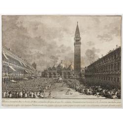
Habita a Serenissimo Duce in Basilica D.Marci ad populum allocutione…
Habita a Serenissimo Duce in Basilica D.Marci ad populum allocutione, ab eoque Dux salutatus, Armamentariorum humeris in sella gestatoria cum duobus proxime consanguineis...
Date: Venice, c. 1766-1770
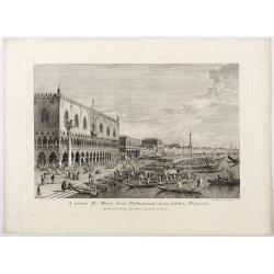
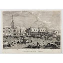
A minore D: Marci Area Dalmatarum ripam.
A minore D: Marci Area Dalmatarum ripam". View of the Riva degli Schiavoni from the east including the Palazzo Ducale in the foreground. Apud Ludovicum Furlanetto su...
Date: Venice, c. 1763
S. Georgii Majoris Ecclesiae prospectus.
S. Georgii Majoris Ecclesiae prospectus". S. Giorgio with the church and quay in sharp perspective.From the series "Prospectum Urbis Venetiarum" (Views of ...
Date: Venice, ca. 1791
Pons Rivoalti, utriumqque Ripae, et Aedes ad Orientem.
Pons Rivoalti, utriumqque Ripae, et Aedes ad Orientem." From the series "Prospectum Urbis Venetiarum" (Views of Venice). 1st state. Published by Lodovico F...
Date: Venice, 1763
Canalis majoris caput qua Venetias ingreditur.
Bucentaurus et Nundinae Venetae in die Ascensionis". The Doge leaving for the Lido on the Bucintoro on Ascension Day.From the series of 12 views entitled Feste Ducal...
Date: Venice, c. 1766
![Ornithon sive Aviarum M. Varronis Pyrro.Ligorio.Neap.inv. [The reconstruction by Pirro Ligorio of the aviary of Marcus Varro].](/uploads/cache/49261-250x250.jpg)
Ornithon sive Aviarum M. Varronis Pyrro.Ligorio.Neap.inv. [The reconstruction by Pirro Ligorio of the aviary of Marcus Varro].
The print, depicting the reconstruction by Pirro Ligorio of the aviary of Marcus Varro in Rome, was printed by Giovanni Orlandi in 1602 from a copperplate originally eng...
Date: Rome, 1581-1602

Itinera Varia Auctoris.
From A Natural History of Uncommon Birds, and of some other rare and undescribed Animals, Quadrupeds, Reptiles, fishes, insects, &c.. The map shows Edwards' journeys ...
Date: London, 1746
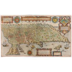
A cidade de Angra na ilha de Iesuxpo da Tercera..
Spectacular perspective view of the harbour and town of Angra on the island of Terceira in the Azores. It was at the time an important port and administrative centre of t...
Date: Amsterdam, 1598
Pons Rivoalti ad Occidentem, cum Aedibus Publicis utrique Lateri adjectis.
Pons Rivoalti ad Occidentem, cum Aedibus Publicis utrique Lateri adjectis."From the series "Prospectum Urbis Venetiarum" (Views of Venice). 1st state. Publ...
Date: Venice, 1763
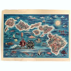
The Dole Map of the Hawaiian Islands.
A terrific, colorful poster of the Hawaiian Islands by Joseph Feher, commissioned for the Hawaiian Pineaple Co. The poster displays all eight of the major islands in the ...
Date: USA, 1950
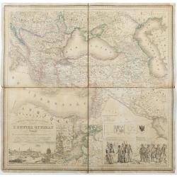
Carte du theatre de la guerre L'Empire Ottoman ..
Very detailed and decorative map of the Ottoman Empire. Lower left a fine panoramic inset (185x80mm) with a view of Istanbul. Next to it a inset map of the Baltic Sea and...
Date: Rouen/ Paris, 1854
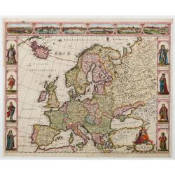
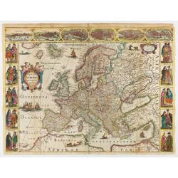
Nova Europae descriptio.
Four panels in columns on each side show portraits of the kings and Queens of European countries. The top border contains panoramas of Rome, Amsterdam, Paris, London, Sev...
Date: Amsterdam, c. 1660
![[Lot of 2 maps] Map of part of New South Wales Australia shewing position of Commonwealth Territory / Map of New South Wales Australia…](/uploads/cache/49457-250x250.jpg)
[Lot of 2 maps] Map of part of New South Wales Australia shewing position of Commonwealth Territory / Map of New South Wales Australia…
Two maps depicting the region of New South Wales and the area designated as the future Commonwealth Territory (which later became the Australian Capital Territory).The fi...
Date: Department of Lands, Sydney NSW, 1911

Leaf on vellum from a antiphonary.
A leaf from a Medieval Antiphonal or Choir Missal for Spanish use, in Latin on extremely heavy vellum. Justification: 360x246mm. Text is in Spanish rounded Gothic hand (R...
Date: Sevilla, ca.1520
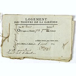
Logement des troupes de la garnison. . .
Seven coupons "Logement des troupes de la garnison ce billet servira pour trente nuits" giving a soldier the right for housing at 738 Rue de Venus in Antwerp in...
Date: Antwerp, 1813
![Venditori di pesci (Anguele). Marchands de petite poissons. [Fish Sellers of Venice]](/uploads/cache/49430-250x250.jpg)
Venditori di pesci (Anguele). Marchands de petite poissons. [Fish Sellers of Venice]
Small Fish Sellers. From a series of lithographs depicting various Venetian trades, published in Venice by Galvani. Subjects include genre figures such as fishmongers, ch...
Date: Venice, c. 1835
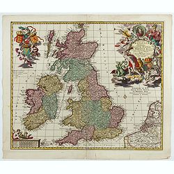
Magnae Britaniae Tabula; Comprehendens Angliae, Scotiae, Ac Hiberniae Regna . . .
Rare Dutch map of the British Isles in very attractive full original color. In this state the wording "Scilly Isles" is added. A decorative title cartouche in t...
Date: Amsterdam, after 1694
