Popular Listings
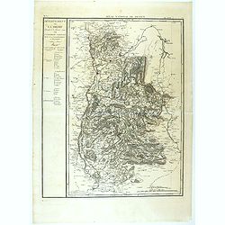
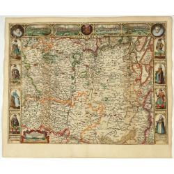
Département de la Drome decreté le 3 février 1790. . .
Map of the region of southeast France. The region of Drome is divided into four districts. On the left, the title with underneath a large explicative text with the divisi...
Date: Paris, 1790-1818

Visiting The Sick. (319).
Caricature by J. Gillray. Charles James Fox, dangerously ill, visited by an entourage of interesting factions: representing the social and ministerial conflict surroundin...
Date: Henry G. Bohn, London, 1840
Selling price: ????
Please login to see price!
Sold in 2025
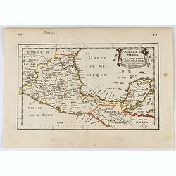
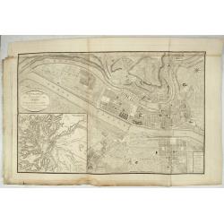
Audience de Mexico.
General map of Mexico after N.Sanson.From the book Nouvelle Relation, Contenant LES VOYAGES DE THOMAS GAGE dans la nouvelle Espagne [..] jusqu'à la Havane, published by P...
Date: Paris, 1756
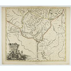
Uffensis Provincia Cum adiacentibus Regionibus.
Volga-Ural Region. From the first regional atlas of Russia, published by the Academy of Sciences in St. Petersburg, expanding on the cartographic work done previously by ...
Date: Academy of Sciences, St. Petersburg, 1745
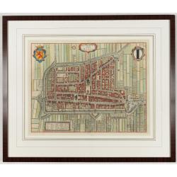
Delfi Batavorum vernacule Delft.
Detailed plan of the city Delft from Frederick de Wit's town book of the Netherlands. The plates are first published by Joan Blaeu one year after the peace of Münster and...
Date: Amsterdam, 1698
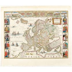
Europa recens descripta à Guilielmo Blaeuw.
On either side columns depicting the manner of dress in the major countries of Europe, surmounted by nine city views and plans.For European mapmakers their own continent ...
Date: Amsterdam, 1644
A New and Accurate Map of the Whole Russian Empire as contained both in Europe and Asia. . .
Detailed map of Russia, from the Sea of Anadyr, Sea of Kamchatka and the Kuril Islands to St.Petersburg. Also includes Tibet, Korea and part of China, with the Great Wal...
Date: London, c. 1747
![FIORENZA [FLORENCE].](/uploads/cache/49141-250x250.jpg)
FIORENZA [FLORENCE].
State 2 of this bird's-eye view of Florence. In the center, under the upper border, the engraved title "Fiorenza". At the top left, a compass rose is represente...
Date: Siena, Pietro Petrucci, ca. 1600
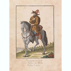
Kirgise à cheval.
Uncommon copper-engraved costume plate from Johann Gottlieb Georgi "Beschreibung aller Nationen des russischen Reichs" (1776), the work stands out for the hand-...
Date: St. Petersbourg, C.G. Müller, 1776-1780
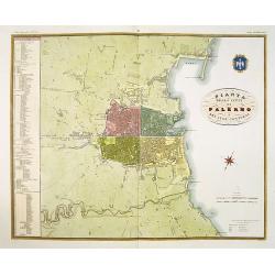
Pianta della citta di Palermo e dei suoi contorni.
Published in Atlante Geografico dell' Italia . Uncommon and decorative town-plan of Palermo. With a numbered key.Engraved by P. Manzoni.
Date: Florence, 1845
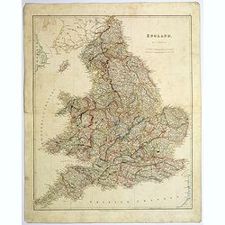
England.
A large and detailed steel-engraved map of England, with each county divided by a different color. Many place names and physical features are shown, illustrating how dens...
Date: London, 1839
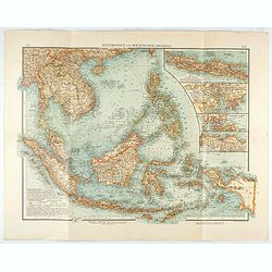
Hinterindien und Malayischer Archipel.
Map of South East Asia with four insets. Shows settlements, roads, railways, telegraph cables, etc. A color key to Dutch, French, British, and Portuguese occupations. Inc...
Date: Leipzig, 1905
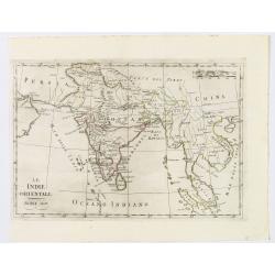
Le Indie Orientali.
A nice map of the East Indies, published in Rome at the beginning of the nineteenth century. Shows from the Persian Gulf across Pakistan, India, and Bangladesh, then sout...
Date: Rome, ca 1803
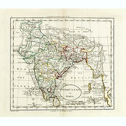
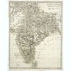
Indoustan ou Inde.
Map of India. The map is based on the Paris Meridian. Only in 1884, at the International Meridian Conference in Washington, D.C., was the Greenwich Meridian accepted.Engr...
Date: Paris, c. 1810

La parte orientale dell' antico.. messico con la Florida..
A splendid two-sheet map of Mexico, including California, Arizona, New Mexico, part of Texas, Baja California and Mexico (west part) and of the Southeast Part of the US, ...
Date: Rome, Calcography, 1797-before 1839
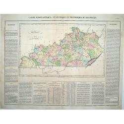
Carte Géographique .. Kentucky.
Detailed map of Kentucky. From J.A. Buchon, "Atlas Gégraphique Statistique, historique et chronologique des deux Ameriques et des isles adjacentes; traduit de l'atla...
Date: Paris, 1825
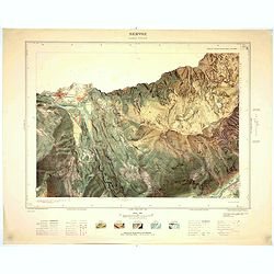
Servoz - Cluses N°8 Sud.
Magnificent 1:10,000 scale color printed map of Servoz (Cluses N°8 Sud) based on stereotopographic ground and aerial surveys carried out in the field in 1950 and rendere...
Date: Paris, 1953
Angliae, Scotiae, et Hiberniae, sive Britannicar : Insularum descriptio.
A rare and ornate map with inset portraits of James First, Henry Prince of Wales Princess Anne of Denmark.Janssonius acquired the copperplate of van den Keere's 1604 Brit...
Date: Amsterdam, 1621
![Amphitheatri Veronen[sis] diligens et accurata delineatio…](/uploads/cache/49136-250x250.jpg)
Amphitheatri Veronen[sis] diligens et accurata delineatio…
The print features the Amphitheater of Verona, it comes from "Speculum Romanae Magnificentiae" (The Mirror of Roman Magnificence). Example of the first state of...
Date: Rome, Antonio Lafreri, ca. 1560
![[The Philippines]](/uploads/cache/49201-250x250.jpg)
[The Philippines]
Fine chart depicting the Islands of the Philippines. Little interior detail is given but the coastlines, settlements and principal coastal features are identified. An att...
Date: Amsterdam, 1724
Paskaart van de Eijlanden Cheuxan Lowang en alle deselfs onderhoorige Eylande. . .
A rare and finely engraved and detailed chart of China's Zhejiang Province, including Ningbo, Zhoushan and Mount Putuo (Powto) and the mouth of the Yangtze Delta, just so...
Date: Amsterdam, 1753
Charte von Ostindien disseits des Ganges im gegenwärtigen Zustande.
A uncommon issue of this detailed map of India, including Ceylon.
Date: Weimar, 1807
Femme de Tatares Nogais.
Uncommon copper-engraved costume plate from the French translation of Johann Gottlieb Georgi's "Beschreibung aller Nationen des Russischen Reichs" (1776), the w...
Date: St. Petersbourg, C.G. Müller, 1776-1777
F. Louys.
A charming bird's-eye view of Fort St Louis at Cayenne. Title in curtain draped at top. French text on verso.The fort is located on Mont Cépérou, with a panoramic view o...
Date: Paris, 1683
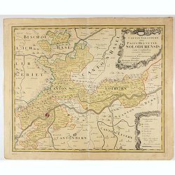
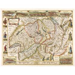
Canton Solothurn sive pagus Helvetiae Solodurensis cum confinibus recenter delineatus per Gabrielem Walserum.
A nice map of Swiss canton centered on Solothurn. Engraved by Tobias C. Lotter.
Date: Augsbourg, 1766
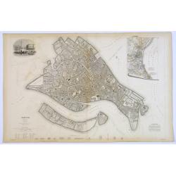
Venice.
A lovely steel engraved plan, on 2 sheets, of Venice by the Society for the Diffusion of Useful Knowledge (SDUK). This English philanthropic enterprise was entirely devot...
Date: London, 1855
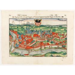
Dell Germania Egrana.
Early woodcut view of the city of Egra (Cheb) in the Czech Republic. From the 1552 Latin text edition of Münster's Cosmographia, which is a short and complete summary of ...
Date: Basel, 1552
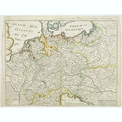
Carte generalle d'allemaigne nouvellement misse en françois et Ampliffiée de tous les Royaumes. . .
Attractive and rare map of Germany, the Low Countries, Austria, Moravia, Switzerland and part of Poland.
Date: Paris, 1632-1660
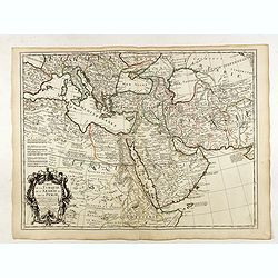
Carte de la Turquie de l'Arabie et de la Perse.
Very rare state with the address : Chez l’Auteur, Rue des Canettes prez St. Sulpice. Avec Privilège, 1701". This early state with "rue des Canettes" imprin...
Date: Paris, 1701
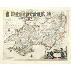
Penbrochia Comitatus et Comitatus Caermaridunum.
Attractive map of the county of Pembroke shire in the UK by J. Blaeu. From a Dutch edition of "Atlas Maior" in beautiful color. With 13 coats of arms, the feath...
Date: Amsterdam, 1648

Tschanibei Ally Bassa. Türckischer Gross-Böthschafter um Kayserl.
Engraving by Johann Martin Bernigeroth (1713-1767) showing a full portrait of the Turkish ambassador in Vienna Ally Bassa.
Date: Leipzig, c. 1750

Tabula nova Poloniae et Silesiae.
Second state, dated 1630 underneath the title. A finely engraved carte á figures with cartouche representing in the four corners of the map : Kings ( on the left side Sig...
Date: Amsterdam, 1630
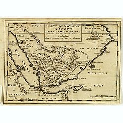
Carte du royaume d'Yémen dans l'Arabie heureuse par G. Delisle. . .
Scarce, little map of the Arabian Peninsula after De. L'Isle. From "Voyage de l'Arabie heureuse par l'Océan Oriental et le Détroit de la Mer Rouge. Fait par les Fran...
Date: Amsterdam, 1716
Caes. Flavius Anicius Iustinianus Semp. August.
The engraving depicts a half length oval portrait of "Caes. Flavius Anicius Iustinianus".Nicolaes de Clerck (de Klerc) was active as engraver and publisher in D...
Date: Amsterdam, Cloppenburch, 1621
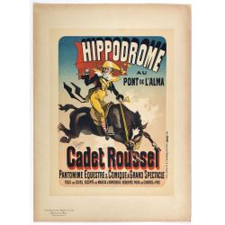
Hippodrome au pont de l'Alma . . .
Chromo lithographed poster, "Hippodrome au pont de l'Alma . . .", by Jules Chéret (1836–1932). Plate 125, published in Maître 32, on July 1898. The "Les Ma...
Date: Paris, Imprimerie Chaix, April 1897
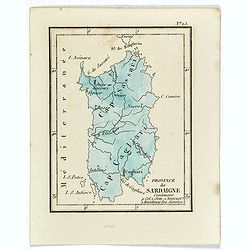
Province de Sardaigne.
Province de Sardaigne Contenant 9 Col. 1 Sem. 1 Noviciat, 2 Résidences 300 Jésuites". Publiée dans "Atlas Universel indiquant les établissemens des Jésuites: av...
Date: Paris, Ambroise Dupont , 1826
Mappae Imperii Moscovitici pars Septentrionalis..
Detailed map of northern Russia embellished with an uncolored pictorial cartouche showing hunting scenes.Prepared by de l'Isle.
Date: Augsburg, 1740
![[Lot of 205 leaves of Germany, Austria, Switzerland, Alsace and Brabant].](/uploads/cache/48263-250x250.jpg)
[Lot of 205 leaves of Germany, Austria, Switzerland, Alsace and Brabant].
1552 MÜNSTER, S. - 205 text leaves illustrated with wood block views and maps relating to Germany, Austria, Switzerland, Alsace and Brabant
Date: Basel, 1552
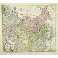
Imperii Russici et Tartariae Universae tam majoris Afiaticæ quam minoris et EuropæTabula.
The map is of interest for the use of East Sea, the sea between Korea and Japan, here called "Mere Orientale Minus".Decorative map covering Russia, Tibet, China...
Date: Nuremberg, 1739
![[Title page] Atlas Nouveau contenant toutes les parties du monde . . .](/uploads/cache/49114-250x250.jpg)
[Title page] Atlas Nouveau contenant toutes les parties du monde . . .
Fine title page of classical architectural design incorporating portraits of royalty and battle scenes.
Date: Paris, 1696

Croquis d'expression. La maman - Est il gentil à manger son sucre d'orge . . . (Plate 31)
The mother: - Isn't he cute licking his barley sugar candy… one would think a young man of twenty years… He absolutely must become a lawyer!.Lithography published by Aube...
Date: Paris, 21 10 1838
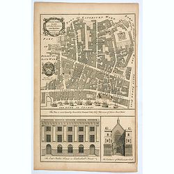
Tower Street Ward with their Divisions into Parishes according to a New Survey.
A fascinating plan of Tower Street Ward, one of the 25 City of London Wards. It lies close to the Tower of London. Much of the ward was lost to Billingsgate Ward in bound...
Date: London, 1757

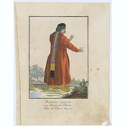
Femme tatares de Tchatsk.
Uncommon copper-engraved costume plate from the French translation of Johann Gottlieb Georgi's "Beschreibung aller Nationen des Russischen Reichs" (1776), the w...
Date: St. Petersbourg, C.G. Müller, 1776-1777
![[Africa].](/uploads/cache/46177-250x250.jpg)
[Africa].
A detailed map from Учебный Географический Атлас published by the very successful St. Petersburg publisher "Cartographic institution A.Ilina" ("Картографич...
Date: St. Petersburg, 1899
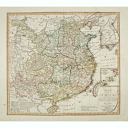
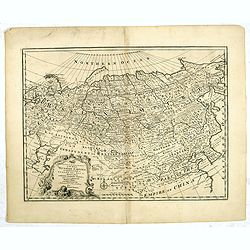
Charte von China nach Murdochischer Projection entworfen. ... Berichtiget, und gezeichnet von H.F.A. Stieler. . .
Uncommon map of China prepared by H.F.A.Stieler, with parts of Taiwan, Tibet, Mongolia and the Korean peninsula, with a great many place names, a key to (and brief explan...
Date: Weimar, 1804
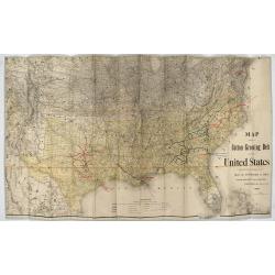
Map showing the cotton growing belt in the United States Prepared for and copyrighted by Geo. H.Mc.Fadden & Bro., cotton merchands based in Phiiladelphia, USA 1892.
The cotton-growing Belts in the Southern States for 1892 A rare map showing the cotton-growing Belts in the Southern States for 1892. Prepared for and copyrighted by G...
Date: Philadelphia, 1892
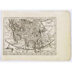
Asie.
This rare map of Asia was published by Jollain in 1667. Published in "Trésor Des Cartes Geographiques Des Principaux Estats de Lunivers".This atlas is based upo...
Date: Paris, 1667
The mape of Hungari newly augmented by John Speede.
A wonderful carte-a-figures map of ‘Hungari’, comprising modern-day Hungary and parts of Slovakia. Showing two sets of four costumed figures on each side of the map and v...
Date: Londres, Bassett and Chiswell, 1626 / 1676
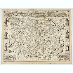
Carte generale des treze cantons de Suisses. Valley Ligues Grise, Maison Dieu et Valteline. 1654
Rare figured border map of Switzerland. In lower corners views of Basel and Zurich. In the top views of Luzern, St. Gallen, Bern, Solothurn and Schaffhausen. In the left ...
Date: Paris, ca. 1654
![[2 sheets] Partie de la Chine. N°.88, 99.](/uploads/cache/33735-250x250.jpg)
[2 sheets] Partie de la Chine. N°.88, 99.
A set of 2 maps covering Taiwan, Ryukyo Islands, Okinawa and southern part of coast of province of Quangdong and part of Fujian. Two columns of text with a historical des...
Date: Brussels, 1825-1827
Selling price: ????
Please login to see price!
Sold in 2023
Carte du Diocese de Narbonne.
Topographically detailed map of the Narbonne diocese in southwestern France. Includes major roads and is supplemented with an extensive index. Inset map plan of the forti...
Date: Paris, 1704
![[Chinese propaganda poster]. We Shall Liberate Taiwan !](/uploads/cache/49024-250x250.jpg)
[Chinese propaganda poster]. We Shall Liberate Taiwan !
Chinese propaganda poster : "We Shall Liberate Taiwan!", by the Hongyingbi (Red Eagle Brush) unit of the Air Force Unit of Nanjing Military Region.The Chinese d...
Date: China, 1971
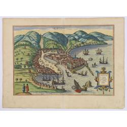
Chios.
The engraving shows the seaport of Chora, the capital of Chios, as seen from the east in a bird's-eye view.
Date: Cologne, ca 1588

Prima Etas Mundi. VI
A very fine presentation of Eve, being created by God from Adam’s side.Page from the richest illustrated Incunable, the famous: Nuremberg Chronicle, published the year th...
Date: Nuremberg, 12 July 1493
Carte des parties nord et ouest de L' Amerique. . .
An interesting map of North America, based upon an earlier map by Thomas Engel. His map of North America was issued in his 'Memoires Observations Geographique' in 1765, a...
Date: Paris, 1772
Nouveau Plan Géométral de la Ville de Lyon, Avec ses projets d'agrandissement & d'embellissement, Divisé par Arrondissements;
Large map of Lyon with, at the bottom left, a large inset depicting "The surroundings of Lyon, according to Cassini" and at the bottom right, a double table of ...
Date: Lyon, Chez Vegezzy, M.d d'Estampes,1826

A Humorous Diplomatic Atlas of Europe and Asia. / 滑稽欧亜外交地図 / Kokkei Ō-A Gaikō Chizu.
A wonderful example of the rare 1904 Kisaburo Ohara satirical 'Octopus Map' of Europe being swallowed by an octopus (Russia). Composed at the outbreak of the Russo-Japane...
Date: Tokyo, April, 1904
Brabantia Ducatus.
Second state of this scarce Carte-a-Figures map of Brabant, published by Peter Verbiest in Antwerp, decorated with three-sided panels. This is the variant without a botto...
Date: Antwerp, 1637
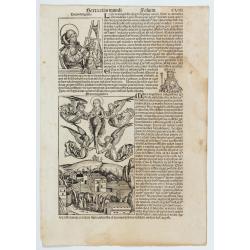
Sexta Etas Mundi. Folium. CXXV
Latin text page with woodcuts on recto and verso of Saints, Kings, and Queens. Including Lucia (Lucia Martyr) is represented with a nimbus and crown of martyrdom. A sword...
Date: Nuremberg, 12 July 1493

Fossa Sanctae Mariae.
Detailed map of part of the country between rivers Rhine and Meuse showing a canal to be dug between 1626 and 1628 between Rheinberg in Germany and Venlo. A deficiency of...
Date: Amsterdam, 1645
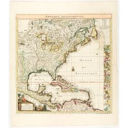
Amerique Septentrionale suivant la carte de Pople faite à Londres en 20 feuilles.
The key sheet to Henry Le Rouge/Popple wall map of the British Colonies in North America. Appears in the author's Atlas Général [1741-62].Key map of the French edition ...
Date: Paris, Le Rouge, 1742

Belgium Foederatum auctius et emendatius edit..
Map of the northern part of the Netherlands. With a decorative title cartouche, with an inset map of South East Asia.
Date: Augsburg 1760
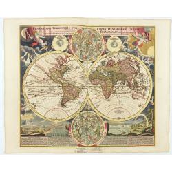
Planiglobii Terrestris Cum Utroq Hemisphaerio.
Vibrantly decorative world map surrounded by vivid engravings of natural phenomena such as waterspouts, a rainbow, earthquakes, and a volcano. Windheads occupy the starry...
Date: Nuremberg, c. 1720
![[Untitled cartoon in pencil.]](/uploads/cache/46791-250x250.jpg)
[Untitled cartoon in pencil.]
A pharmacy cartoon in French, drawn probably in the first half of the last century. It depicts a pharmacist giving some advice to another, seen crushing a powder with a p...
Date: French, ca. 1950
Sexta Etas Mudi. Lucas Evagelista. Folium CVIII.
A very nice presentation of Lucas the Evangelist (100x80mm.) and the representation of Maria Magdalena held by angels 210x135mm.).VERSO : Showing the line of the popes Cl...
Date: Nuremberg, 12 July 1493
Description geographique, historique, chronologique, politique, et physique de l'empire de la Chine et de la Tartarie chinoise.
1770 DU HALDE, Jean Baptiste. - Description geographique, historique […] de la Chine et de la Tartarie chinoise. The first definitive European work on the Chinese empire....
Date: Paris, P. G. Le Mercier, (vol. 1-3) 1770 / (vol.4),1735
![[Europe].](/uploads/cache/46155-250x250.jpg)
[Europe].
A detailed map from Учебный Географический Атлас published by the very successful St. Petersburg publisher "Cartographic institution A.Ilina" ("Картографич...
Date: St. Petersburg, 1899
![[Haida Gwaii,] Baye Swallow . . . / Havre Byron /Côté septentrional de la plus grande des Isles de la Reine Charlotte. . . .](/uploads/cache/25888-250x250.jpg)
[Haida Gwaii,] Baye Swallow . . . / Havre Byron /Côté septentrional de la plus grande des Isles de la Reine Charlotte. . . .
Map of Swallow's Bay and a coastline profile of the Queen Charlotte Islands and Captain Byron's Heaven.Queen Charlotte Islands, with their modern name Haida Gwaii, is an ...
Date: Paris, 1774
![[Lot of 5 leaves] Noerdlinga civitas imperialis…/ Nemetum civitatis…Spiram appellant / Situs & figura… Trevirensis / Situs civitatis Confluentinae… / Civitas Lunaeburgensis…](/uploads/cache/48259-250x250.jpg)
[Lot of 5 leaves] Noerdlinga civitas imperialis…/ Nemetum civitatis…Spiram appellant / Situs & figura… Trevirensis / Situs civitatis Confluentinae… / Civitas Lunaeburgensis…
1552 MÜNSTER, S. - Five text leaves with woodblock-printed early bird's-eye views of Nördlingen, Speyer, Trier, Koblenz, and Lüneburg
Date: Basel, 1552

Leaf from a French (Paris) book of hours.
Leaf from a French (Paris) book of hours, written in black ink, 16 lines of text. Recto: Text starts at Matins,the beginning of the hours to the holy Virgin "Ïncipi...
Date: Paris ca. 1420
Nova et accurata Foederatarum Orovinciarum Inferioris Germaniae descriptio… 1615 P.Kaerius.
The oldest know map of the Dutch Republik. The extremely rare 1615 edition of the map of the Netherlands. The map is better from from the Cloppenburg editions of the Atl...
Date: J.Janssoius, Arnhem, 1615
De Nieuwe en Onbekende Weereld: of Beschryving van America en 't Zuid-Land.
FIRST EDITION. "This is a classic book on America and is much sought after by collectors of Americana as it contains, on p. 124, one of the first views of New York N...
Date: Amsterdam, Jacob Meurs, 1671
Vienne.
Charming view of Vienna. Title in curtain draped at top. French text on verso.From the original 1683 text edition of "Description d'Univers. . ." by Allain Mane...
Date: Paris, 1683
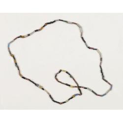
Dutch Trade Bead.
An extremely rare necklace made from authentic early 17th-century glass beads produced in the Netherlands. This rare and early Dutch Trade bead is built up from irregular...
Date: Middelburg, before 1623
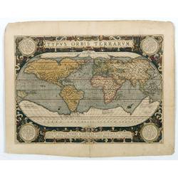
Typus Orbis Terrarum.
Ortelius' third and last world map is dated 1587 under the author's signature. The earlier border of clouds has been replaced by a more intricate and elegant lattice of s...
Date: Antwerp, 1592/1601
Nova Helvetiae Tabula.
A most decorative "carte à figures" map with panoramic views of Lucern, S.Gal, Bern, Solothurn, Schafhausen in upper border and Basel and Zurich in lower left a...
Date: Amsterdam, 1630

Secunda etas mundi. Folium XIII.
SCHEDEL, H. - Nuremberg, 1493 - This world map provides a window onto the late medieval imagination, published the year that Columbus returned to Europe after discovering...
Date: Nuremberg, 12 July 1493
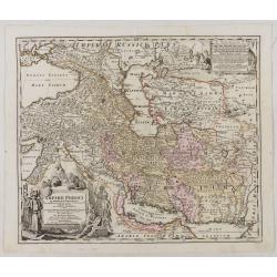
Imperii Persici in omnes suas Provincias . . . Exacte Divisi Nova Tabula Geographica. . .
Showing the eastern part of Turkey and Cyprus, Palestine, Persian Gulf, including Gulf of Oman, Caspian Sea, Iran and the north-west territories of India.Embellished with...
Date: Ausburg, 1730
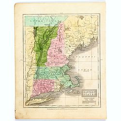
Eastern States.
A map of the eastern US seaboard from Long Island north to Lower Canada, comprising the states of Connecticut, Rhode Island, Massachusetts, New Hampshire, Maine, Vermont ...
Date: Connecticut, 1839
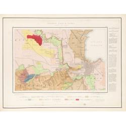
Geological Survey of Victoria.
The portfolio with the gold stamped title "Geological Survey of Victoria", contains 51 sheets maps. There is a pocket attached to the inside front cover contain...
Date: Mining and Geological Department, Melbourne, ca. 1864
