Popular Listings
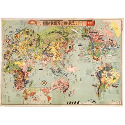
Japanese Stereotype Map of the World from 1932 Share Hitome de wakaru Manga sekai genjō chizu. At a glance: Cartoon Map of the Current World Situation. 目でわかる 漫画世界現状地圖
An extraordinary satirical map of the world was seen through Japanese eyes in the early 1930s as Japanese imperial ambitions strengthened. The map was published as an edi...
Date: Tokyo, Showa 7, or 1932

Carte particuliere d'une grande partie des estats situez sur le haut rhein et sur les rivieres qui si déchargent comme sont L'Alsace, la Souabe et la Lorraine,&c. . .
Detailed map of Alsace, Lorraine and Souabe, centered on the River Rhine.
Date: Paris, 1705

Carte du Katay, ou Empire de Kin : pour servir a l'Histoire de Jenghiz Khan, raportée dans l'Histoire generale des voyages, tirée de l'Angloise.
The map is of interest for the use of East Sea, the sea between Korea and Japan, here called "Mer de Corée".Fine map of Korea and China's Yellow Sea. Complete t...
Date: Paris, 1750
Selling price: ????
Please login to see price!
Sold in 2023
Leaf on vellum from a printed Book of Hours.
24 lines of printed text, surrounded by renaissance borders decorated with flowers, vases and religious scenes.From the press of the leading Parisian publisher and illumi...
Date: Paris, Germain Hardouyn, c.1520-1540
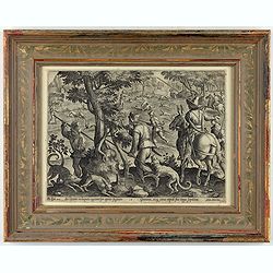
Sic leporem in laqueos agitnat per aperta fugacem - Gramina, siq canes rapidi sua terga sequutur
This is a plate from a series "Venationes ferarum, avium, piscium, pugnae bestiariorum & mutuae bestiarum". Published by Philippe Galle (Haarlem 1537 - 1612...
Date: Antwerp, Philips Galle, ca 1596

Нам знания станут опорой в труде (= Nam znaniia stanut oporoi v trude = Knowledge will become a support in our workforce).
Original vintage Soviet motivational poster by Y. Tupitsyn, with in top Нам знания станут опорой в труде (= Nam znaniia stanut oporoi v trude) = Knowledge will become a s...
Date: Moscow, 1977
![Stampalia. [Map of Astypalaia]](/uploads/cache/45244-250x250.jpg)
Stampalia. [Map of Astypalaia]
Very rare map of the Greek island Astypalaia. The island is known in Italian as Stampalia. Published in the first edition of "Viaggio da Venetia, a Costantinopoli. P...
Date: Venice, Giacomo Franco, 1598

Nova Virginia Tabula.
A beautifully engraved map, derived from the highly influential map by Captain John Smith in 1612, showing Chesapeake Bay and the surrounding area. The decoration of this...
Date: Amsterdam, J.Meurs, 1671
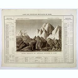
Carte des Principales Montagnes du Globe.
A nice detailed depiction of the principal mountains of the world from Buchon's Atlas Gégraphique Statistique, historique et chronologique des deux Ameriques et des isles...
Date: Paris, 1825
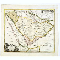
Arabiae Felicis, petrae et desertae.
A very striking map with a finely decorated title cartouche, published by Valk & Schenk, utilizing Jansson's original plate. Interestingly, this map uses the names th...
Date: Amsterdam, 1720
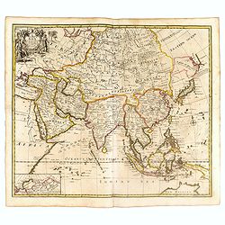
A New Map of Asia from the latest Observations Most Humbly Inscrib'd to the Right Honbl. George Earl of Warrington &c.
Fine map of Asia, with decorative title cartouche flanked by two figures in Asian dress, along with flora and fauna of the continent., based on the work of Guillaume De L...
Date: London, 1721
![[Butterflies]](/uploads/cache/25587-250x250.jpg)
[Butterflies]
Plate CXXIV from Carl Gustav Jablonsky and J.F.W. Herbst: "Natursystem aller bekannten in- und ausländischen Insecten", engraved by Bodenehr. Carl Gustav Jablon...
Date: Berlin, J. Pauli, 1785-1806
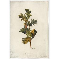
Chêne commun.
Engraved by P.F. Le Grand after designs by the Dutch born Gerard van Spaendonck (1746-1822).Taken from the rare work "Fleurs dessinées d'après nature. . . receuil ut...
Date: Paris, c. 1800

L'Empire de la Chine. . .
Detailed map of China, Korea and Taiwan. The large title cartouche is resplendent in the French style with musicians, a dancer, and various accouterments representative o...
Date: Paris, dated 1750
![[Set of 6 maps] Charta öfver Storfurstendömet Finland på Friherre S. G. Hermelins Anstalt och Omkostnad. Sammandragen och författad af C. P. Hällström. Philos. Magister och Auscultant i Kongl. BergsColl. 1799.](/uploads/cache/34482-250x250.jpg)
[Set of 6 maps] Charta öfver Storfurstendömet Finland på Friherre S. G. Hermelins Anstalt och Omkostnad. Sammandragen och författad af C. P. Hällström. Philos. Magister och Auscultant i Kongl. BergsColl. 1799.
This is a beautiful set of a key map and five separate maps of Samuel Gustav Hermelin's map of Finland. The maps have been engraved by Fredrik Akrel, a very skilled and p...
Date: Källa: J.Strang & E.- S. Harju: Suomen karttakirja 1799
Volume III of the monumental atlas, ‘L’Orbe Cattolico ossia Atlante Geografico Storico Ecclesiastico’.
PETRI Girolamo's extremely rare Atlas volume III of the monumental atlas, ‘L’Orbe Cattolico ossia Atlante Geografico Storico Ecclesiastico’, respectively depicting eccl...
Date: Rome, 1858

Plan de Paris commencé l'année 1734, Dessiné et gravé sous les ordres de Messire Michel Etienne Turgot, prévost des marchands.
FIRST EDITION of Turgot's Monumental Joined View of Paris, stretching to over 10 Feet. This expansive large-scale engraved view of Paris covers the first eleven arrondiss...
Date: Paris, 1739
![[ Hieroglyph representing the Cihuacohuat Goddess ].](/uploads/cache/27578-250x250.jpg)
[ Hieroglyph representing the Cihuacohuat Goddess ].
Aquatint depicting a hieroglyph representing the Cihuacohuat Goddess engraved by DKB. Plate N°68.From Giulio Ferrario's work Le Costume Ancien et Moderne ou Histoire du g...
Date: Milan, 1827

A new & accurate map of the Empire of China from the Sieur Robert's Atlas. With improvements.
An excellent early engraving of China and Korea that appeared in Sieur Robert de Vaugondy's Geographical Dictionary (London: 1759). Decorative title cartouche on the uppe...
Date: London, 1759

Carte Geographique, Statistique et Historique du Perou.
A nice detailed map of Peru from Buchon's Atlas Gégraphique Statistique, historique et chronologique des deux Ameriques et des isles adjacentes traduit de l'atlas exécuté...
Date: Paris, 1825

Isole dell'Indie. . .
A beautiful and flamboyantly engraved large-scale map of the East Indies, including the Malay Peninsula, Cambodia, the Philippines and all of Indonesia and the Spice Isla...
Date: Venice, 1696
![[ Mexican weapons ].](/uploads/cache/27576-250x250.jpg)
[ Mexican weapons ].
Aquatint depicting an Oaxaca monument representing a warrior engraved by Bonatti. Plate N°66.Oaxaca is the historic home of the Zapotec and Mixtec peoples, and contains m...
Date: Milan, 1827
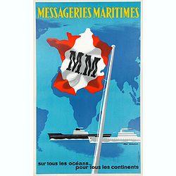
Messageries Maritimes, sur tous les océans, pour tous les continents.
Original lithographed poster from the 1950s by Jean Desaleux. The poster has a blue background and a map of the continents and oceans. France is in the colors of the Mari...
Date: Paris, ca. 1950

Isola d'Oleron, nella piaggie occidentali della Francia.
A beautiful and rare map showing île d'Oleron.The remarkable Vincenzo Coronelli (1650-1718), encyclopaedist, geographer, inventor and Doctor of Theology, was citizen of t...
Date: Venice, 1690

Société de la Charité Maternelle à Paris. Plan de le ville de Paris, Divisé par Quartiers avec Nomenclature.
>Rare atlas de Paris dressé par E. Devrainne, divisé en 80 quartiers et colorié par Le Roux (Le Roux pinxit). Illustré d'une page de titre aux armes de Paris avec sa d...
Date: Imprimerie Mercier, Clichy, 1876
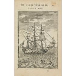
(Shipping)
Finely etched depiction of a vessel, with a lettered key. With explanatory text on verso.From the French text edition of Description d'Univers.. (5 volumes), 1683. By All...
Date: Paris, 1683

1) Le Kakatoës à Huppe Jaune. 2) Le Lori Tricolor. Le Perroquet Vert.
Noteworthy bird print from 1839 Furne edition of the Histoire naturelle, générale et particulière by Georges-Louis Leclerc, Comte de Buffon.Engraved by Fournier after Edo...
Date: Paris, 1838 - 1839

La pericolante ostinata. Papagallo No. 20 Anno II.
Design by Augusto Grossi. Taken from the Italian satirical newspaper Il Papagallo, a satirical magazine founded in January 1873 by Augusto Grossi (1835-1919), which speci...
Date: Bologne, 1874

Marine parallel rulers in brass.
Very fine marine parallel rulers in brass. The parallel ruler is the oldest and most traditional way to measure and trace routes and bearings. The principle is simple: th...
Date: Paris, ca. 1880
![Posesiones de America : Isla de Cuba. [together with] Isla de Cuba. . .](/uploads/cache/23458-250x250.jpg)
Posesiones de America : Isla de Cuba. [together with] Isla de Cuba. . .
Wall size sea chart and map of land areas showing all of Cuba, part of Florida Keys plus San Adios and Salvador Grande in the Bahamas.Minute topographical, political, and...
Date: Madrid, 1853 / 1851
![[ Map of the island Nexos]](/uploads/cache/45289-250x250.jpg)
[ Map of the island Nexos]
1598 - ROSACCIO, Giuseppe. - Very rare map of the island of Naxos published in the first edition of "Viaggio da Venetia, a Costantinopoli".
Date: Venice, Giacomo Franco, 1598
Selling price: ????
Please login to see price!
Sold in 2026
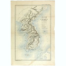
TYO SYEN Corée par les Missionnaires de Corée de la société des missions etrangéres.
A very nice map and rare map of Korea. Prepared by R.P.Carceri who was an missioner active for de la Sociéte des Missions Etrangères.Published as a supplement to Journal ...
Date: Lyon, 1872
Selling price: ????
Please login to see price!
Sold in 2023

Plan de la ville de Maestricht avec ses attaques commandées par M. le maréchal de Saxe, depuis le 15 avril jusqu'au 3 may 1748 . . .
A plan of Maastricht rising after the capture of the city by the French troops led by the Marshal of Saxony. The city was besieged between 15 April and 3 May 1748, during...
Date: Paris, 1781
![[Title page for] Atlas Minor de Guerard Mercator. . .](/uploads/cache/47933-250x250.jpg)
[Title page for] Atlas Minor de Guerard Mercator. . .
Title page from a 1608 French edition of the Atlas Minor (351:11). The title page is similar to that in the Latin edition of 1607, but a slip of paper with the engraved t...
Date: Amsterdam, 1608

Het stadhuis, van vooren.
The former Amsterdam Town Hall, now the Royal Palace. Copper engraving by Frans de Bakker after Reinier Vinkeles (1741-1816).From the well-known description of Amsterdam ...
Date: Amsterdam, 1765

Urbium Londini et West-Monasterii nec non Surburbii Southwark Accurata Ichnographia ,., Neuester Grundris der Staedte London und West-Munster, Samt der Vorstadt Southwark ,.,
Detailed plan of London, extending from Grosvenor Square in the west to Mile End to the east, To the right inset views of St, James's Square, and Custom House, elevations...
Date: Nuremberg, 1736

A ship's hour glass.
Maritime hourglass with blown glass bulbs, orange sand, junction ring covered with cord, the circular ebony frame with six turned baluster columns.The invention of the ho...
Date: The Netherlands, Germany, ca. 1750
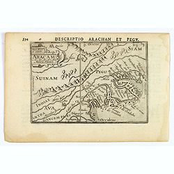
Aracam.
A rare miniature map of Thailand and Burma. Title cartouche on the upper left corner. First published in 1598 in his 'Caert-Thresoor', the plates were executed by the mos...
Date: Amsterdam, 1606

A view of Westminster bridge. Vue du pont Westminster.
A very decorative and extremely rare collection of river Themes and Westminster Bridge in London, including a six-line description in French and English. Published by Jac...
Date: Paris, ca.1750
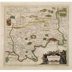
Middle-sexia.
Double-page map of the old Middlesex County, including a marvelous depiction of London on the Thames in the lower right corner. Decorative cartouche and coat of arms. Lat...
Date: Amsterdam, 1662
Selling price: ????
Please login to see price!
Sold in 2024

Ce que les Anglo-Saxons ont perdu en Extrême-Orient.
Illustrated Vichy propaganda War & Propaganda poster showing a map of South East Asia, with Indonesia, Philippines, Thailand, etc., among photos and explanations abou...
Date: Paris, 1943

Languedoc - Foix Roussillon.
Very decorative, informative map of Languedoc - Foix Roussillon region in south eastern France. Including the towns of Carcassonne, Montpellier, Albi, Toulouse, etc.The m...
Date: France, 1943
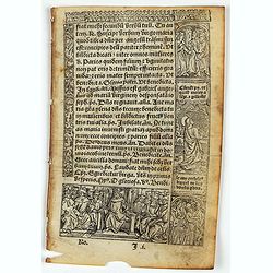
![[Text page with Saint Appolonia, the patron saint of dentistry. - Sexta Etas Mundi. Folium. CXX ].](/uploads/cache/26526-250x250.jpg)
[Text page with Saint Appolonia, the patron saint of dentistry. - Sexta Etas Mundi. Folium. CXX ].
Text page with woodcuts of Abdon & Senen, Agatha, Appolonia, Serapion, Meniacus, Victoria. With a woodcut of Appolonia, the patron saint of dentistry. Because of the ...
Date: Nuremberg, 12 July 1493

Profil de la renomée ville et port d'Emstredam cappitalle des estats de Hollande.
Extremely rare panoramic town-view of Amsterdam seen from the river IJ.Exceptional bright, sharp example.The print is skillful copy of the print of Matthieu Merian, now w...
Date: Paris, 1647

Carte routière de l'Indochine. Des kilomètres en sécurité sur Goodrich.
Advertising poster for the brand Goodrich, showing a map of Indochina.Goodrich Corporation is a former American company specializing in civil and military aeronautical eq...
Date: Paris, ca 1934

Carte du Katay ou Empire de Kin. . .
The map is of interest for the use of Mer de Corée for the sea between Korea and Japan. Fine map of Korea and China's Yellow Sea. Complete title in top: Carte du Katay ou...
Date: Paris, 1750

Carolinae Floridae nec non Insularum Bahamensium cum partibus adjacentibus delinatio ad Exemplar Londinense in lucem edita . . . Ao. 1755.
The German edition of this map of Carolina, Florida, and the Bahama Islands in full original colors. Published in Seligmann's "Sammlung verschiedener auslaendischer ...
Date: Nuremberg, 1755

Sint Catharinakerk te Eindhoven.
Uncommon woodblock engraving of St.Catharina church of Eindhoven, built by the well-known architect P.Cuijpers. Published in Katholieke Illustratie.The "katholieke i...
Date: 'sHertogenbosch, Henri Bogaerts, 1875
![Vincula dura Joseph pro falso crimine perfert. Sed deus a falsa hunc suspicione leuat. Gene[sis] 40](/uploads/cache/47693-250x250.jpg)
Vincula dura Joseph pro falso crimine perfert. Sed deus a falsa hunc suspicione leuat. Gene[sis] 40
A superb example of this illustration from the series of the Story of Joseph. Joseph in Jail.Copper engraving published in " Thesaurus sacrarum historiarum veteris t...
Date: Antwerp, 1585
![[A Chinese vessel ] Naves Chinensibus usitatae velis arundineis & anchoris ligneis.](/uploads/cache/29498-250x250.jpg)
[A Chinese vessel ] Naves Chinensibus usitatae velis arundineis & anchoris ligneis.
Showing a Chinese vessel, print taken from Linschoten's famous voyages to the East of 1583-92, here published by De Bry the year after they first appeared as a separate b...
Date: Frankfurt, 1599

Carte de la Mer Rouge, depuis Moka jusqu's Gedda. . . .
Chart of the Red Sea. With 3 inset maps of Shake Omare, Goofs and Gedan. D'Après De Mannevillette (1707-1780) was one of France's first hydrographers. When the first edit...
Date: Paris, 1753
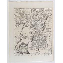
A map of Quan-Tong or Lyau-Tong province, and the kingdom of Kau-Li or Korea . . .
Detailed map of Korea, Liaodong, and the tip of Shandong Province prepared by Thomas Kitchin for Thomas Salmon's Universal Traveller, based on D'Anville's landmark map of...
Date: London, 1747

Nova Germaniae Descriptio..
A finely engraved carte à figures, with the side borders depicting emperors, while the upper and lower panels contain finely engraved miniature town prospects, among them...
Date: Amsterdam, 1632
![Amerique Septentrionale divisée en ses principales parties. . .1692. [California as an Island]](/uploads/cache/27961-250x250.jpg)
Amerique Septentrionale divisée en ses principales parties. . .1692. [California as an Island]
A very good impression of Jaillot's large map of North America, showing California as an Island, based upon Sanson's landmark map of 1656. A first state.The map shows the...
Date: Amsterdam, c.1692

Nieuwe kaart van het Koningrijk der Nederlanden. . .
Uncommon map of the Netherlands prepared by J.S. Smulders and P. H. Witkamp and lithographed by Z.M. den Koning in the Hague. Dated.Showing The Kingdom of the Netherlands...
Date: The Hague, 1874
Harlekin en Bombario en den rouw.
Harlequin and Bombario in mourning, taken from Het groote tafereel der dwaasheid : vertoonende de opkomst, voortgang en ondergang der actie, bubbel en windnegotie, in Vra...
Date: Amsterdam, 1720
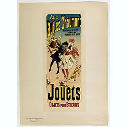
Aux buttes Chaumont.
Chromo lithographed poster, "Aux buttes Chaumont.", by CHERET, J. Plate 141, published in Maître 17, on April 1898. The "Les Maîtres de l'Affiche" con...
Date: Paris, Imprimerie Chaix, April 1898

Optique de St.Cloud.
This perspective view of St. Cloud comprises 6 hand colored images of the grand Bassin d'Apollon viewed through an square and two round holes cut out from the front card ...
Date: Paris, ca.1845

Peregrinatie Jesu Christu Een ordentliche beschrijvinge des Heijligen landts....
Very rare separately map of the Holy Land engraved by Joannes van Doetecum Jr. Oriented to the east. The shoreline runs from "Antaradus" in Syria to "Rhino...
Date: Amsterdam, ca. 1595
![[Text page with Kings and historical personalities.] Quita etas mundi. Foliu. LXXXIII](/uploads/cache/26874-250x250.jpg)
[Text page with Kings and historical personalities.] Quita etas mundi. Foliu. LXXXIII
Text page with woodcuts of Kings and historical personalities.Page from the richest illustrated Incunable, the famous: Nuremberg Chronicle, published the year that Columb...
Date: Nuremberg, 12 July 1493

Indian painting on paper.
Fine miniature, presenting a couple in love making position, set in an interior. The miniature has been painted in India in late 19th - early 20th century. The miniature ...
Date: India, ca. 1900

Circoscrizione delle Provincie ecclesiastiche e Diocesi nei regni del Belgio, ed Olanda (Tav LXI)
This large-format map showing Belgium and Holland with its different dioceses. The map is finely engraved and beautifully colored and was prepared by Girolamo Petri, a la...
Date: Rome, 1858
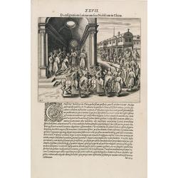
A Parade of Noblemen in China.
This famous and desirable scene from Linschoten's famous voyages to the East of 1583-92 is here published by De Bry the year after they first appeared as a separate book....
Date: Frankfurt, 1599
Grand atlas universel ou collection de cartes encyprotypes, générales et détaillées des cinq parties du monde.
Large folio atlas containing 8 general one-sheet maps, and 8 detailed four-sheet maps: Containing2 World maps- "Mappe-monde sur la projection de Mercator. Carte ency...
Date: Paris, Desray, 1816
![[ Niagara Falls ]](/uploads/cache/27543-250x250.jpg)
[ Niagara Falls ]
Two aquatints depicting the Horse Shoe Fall (also known as Canadian Falls at the top) and the Fort Schloper Fall (bottom) engraved by Biasolé. From Giulio Ferrario's work...
Date: Milan, 1827

Indonesia.
Original vintage travel advertising issued by the Indonesian Council for Tourism featuring a colorful pictorial map marking the islands and oceans with images of local pe...
Date: Jakarta, ca. 1955

(Art-déco gouache)
Outstanding "art deco" gouache (unsigned) from the workshop of "Robert Pichon. Ateliers de Dessin et Lithographie – 10, rue Rochechouart – Paris. The gouac...
Date: Paris, ca. 1930
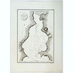
Plan du Port du Nord de la Baie de la Recherche.
A French maritime chart of the plan of the northern portion of Recherche Bay on the S.E. tip of Tasmania. The chart has some physical detail, outlining trees and hills, b...
Date: Paris, ca 1807
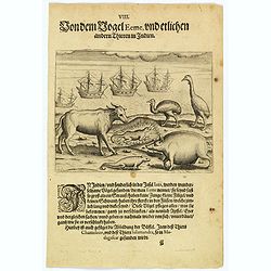
The bird called 'Eeme' and other creatures of India.
Especially on the island of Java and in India, a strange bird called an 'Eeme' is found. It is almost as large as an ostrich with strong and sturdy legs, but it has no to...
Date: Frankfurt, 1598

Neapolis.
A rare panoramic of Naples with over the whole length of the lower part 3 columns of poems in Latin, Dutch and French.Published by Dancker Danckerts (1634-1666).
Date: Amsterdam, 1660
![[Title page] Atlante Novissimo, Tomo I . . .](/uploads/cache/43898-250x250.jpg)
[Title page] Atlante Novissimo, Tomo I . . .
Decorative Venitian frontispiece from Antonio Zatta's "Atlante Novissimo tomo I".
Date: Venice, 1779

Carte du Golfe de Bengale, mer des Indes et rivieres du Gange . . .
Detailed scare map of the Southern part of India with Ceylon. Good detail along the coasts of Malabar, Coromandel, the Maldives islands and the Kingdoms of Visipour, Golc...
Date: Leiden, 1719

Mappa Humoristico da Europa.
A really unusual and lovely map, published in Portugal at the outbreak of The Great War in 1914. This outbreak of war in Europe was the result of a complex sequence of ev...
Date: Lisbon, 1914

Amsterdam Ville du Comté de Hollande et la plus considerable des Provinces Unies. . .
A very decorative and extremely rare town-view of Amsterdam, including a numbered (1-18) key in lower part. Extensive shipping on the IJ. To the left the headquarters of ...
Date: Paris, ca.1750
![Terre de Diemen. Tombeaux des naturels. [plate XVI]](/uploads/cache/46279-250x250.jpg)
Terre de Diemen. Tombeaux des naturels. [plate XVI]
An aboriginal campfire, near the ruins of an old wooden fence, and a dead tree, after the original sketches by Lesueur, from Voyage de découvertes aux terres Australes by...
Date: Paris, 1824
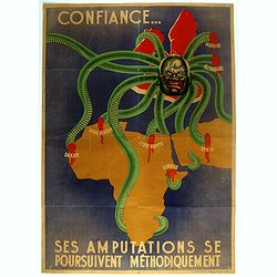
Ses Amputations se Poursuivent Methodiquement.
Propaganda map, produced under the NAZI collaborating Vichy French regime and designed to inspire revulsion and hatred of the English among the French, while frequently d...
Date: Paris, ca. 1941 / ca. 1960
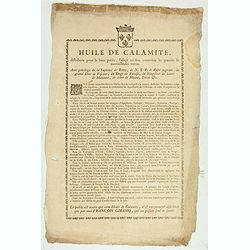
Huile de Calamite.
Oil to heal all ailments, only distributed by François Giramo, who alone owns the secret. Surrounded by a decorative border and the Royal coat-of-arms.With privilege of t...
Date: France, c.1790

Carte de la Coste d'Arabie.
Uncommon issue of this very nice map of the Arabian peninsula. Depicted is Saudi Arabia, Red Sea and the Persian Gulf.With French text in title cartouche and an additiona...
Date: Amsterdam, 1773
![[ Chief Regolo ].](/uploads/cache/27568-250x250.jpg)
[ Chief Regolo ].
Aquatint depicting chief warriors engraved by G. G. Plate N°58.Cacique from the taíno word for the pre-Columbian tribal chiefs or leaders of the Taino tribes in the Baham...
Date: Milan, 1827
![[ Mexican weapons ].](/uploads/cache/27575-250x250.jpg)
[ Mexican weapons ].
Aquatint depicting Mexican weapons engraved by DKB. Plate N°65.From Giulio Ferrario's work Le Costume Ancien et Moderne ou Histoire du gouvernement, de la milice, de la r...
Date: Milan, 1827
