Popular Listings

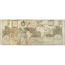
Stoel des Oorlogs in America Waar in Vertoont Werden Alle Desself Voornaamste Eylande . . .
Large impressive map of the West Indies with the Gulf of Mexico and Florida. The map shows prominently in the center Cuba, Haiti, the Bahamas and Florida, which is here m...
Date: Amsterdam, c. 1720
Atlas van Zeevaert en Koophandel door de Geheele Weereldt.
Engraved frontispiece, title printed in red and black with engraved vignette, engraved dedication to the Dutch East India Company, 32 double-page engraved charts in very ...
Date: Amsterdam, 1745
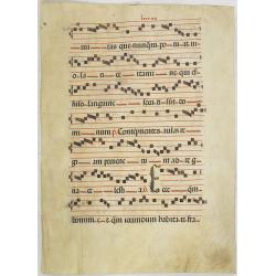
Leaf on vellum from a antiphonary.
A leaf from a Medieval Antiphonal or Choir Missal for Spanish use, in Latin on extremely heavy vellum. Justification: 370x250 mm. Text is in Spanish rounded gothic hand (...
Date: Sevilla, ca.1520
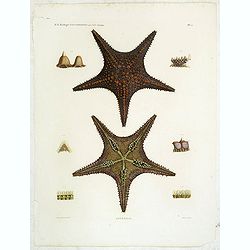
Astéries.
Decorative engraving of star fishes, by Macret and Leleu. Marie Jules César Lelorgne de Savigny (April 5, 1777 - October 5, 1851) was a French zoologist. In 1798 he trav...
Date: Paris, 1822

Carte géologique détaillée. Jezzîne.
Geological or soil map showing part of Lebanon with Jezzîne, including a legend with signs of the different geological ages and giving many information of greatest inter...
Date: Liban, Service geographique des F.F.L., 1945.
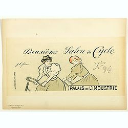
Lexeme Salon du Cycle.
Chromo lithographed poster of Les Maîtres de l'Affiche being plate n°51. The "Les Maîtres de l'Affiche" contained 256 small for lithographic prints of the be...
Date: Paris, Imprimerie Chaix, 1897

Designs for two porcelain bowls with Chinese design.
With numbers 4.601, 4.818. In top "Planche N° d'ordre : 03004.Original design created by the Sevres artist Gabriel Fourmaintraux ( 1886 - ) at about 1910 to serve a...
Date: Desvres, 1905 - 1925
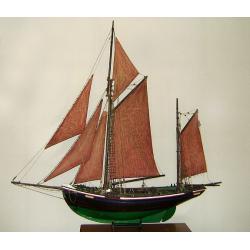
MAUREEN Shipping model of a fishing boat.
This type of fishing ships were used by the Dutch fisherman to fish for codfish, and even reached with them into the Canadian waters.Overall dimensions: 1400 x 100 x 230m...
Date: Netherlands, ca. 1850
![Les Isles Philippines [on sheet with] Islas de los Ladrones ou Isle des Larrons.](/uploads/cache/42023-250x250.jpg)
Les Isles Philippines [on sheet with] Islas de los Ladrones ou Isle des Larrons.
Sanson's important mid-seventeenth-century map of the Philippines and tha Ladrones.It was first engraved by J. Somer for the elder Nicolas Sanson with a privilege for twe...
Date: Amsterdam/Utrecht, 1654
![[Lot of Five Pacific Brand crate labels]](/uploads/cache/45706-250x250.jpg)
[Lot of Five Pacific Brand crate labels]
Five fruit crate label for Pacific Brand, showing a lemon and a map of the Pacific Ocean, centered on Hawaii and including a part of California and Asia, with also Austra...
Date: Santa Barbara, 1917

Tabula Ducatus Brabantiae.
Detailed map orientated west to the top.
Date: Amsterdam, 1680
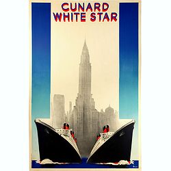
Cunard White (Queen Mary et Queen Elizabeth de la Cunard Line).
Rare original vintage travel advertising poster for Cunard White Star, the fastest Ocean Service in the World. Stunning Art Deco style illustration of the two majestic fl...
Date: Paris, 1938

Russie Européenne . . .
Detailed map of European part of Russia, including Finland and Lapland.Gilles Robert de Vaugondy (1688–1766), also known as Le Sieur or Monsieur Robert, and his son, Di...
Date: Paris, ca. 1753
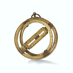
Very fine brass astronomical equinoctial ring with two brass circles.
Very fine brass astronomical equinoctial ring with two brass circles with engraved foliage decoration, signed "Jean-Baptiste-Nicolas Delure A Paris", on the han...
Date: Paris, undated, ca. 1690

ARMENIEN. Costumes de l'Empire Ottoman 9.
A beautiful hand colored lithograph of an Armenian published in the French work "Galerie Royale de Costumes peints d´après nature par divers artistes et lithograph...
Date: Paris, Chez Aubert & Cie., 1842-1848
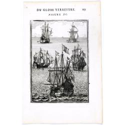
DU GLOBE TERRESTRE - Figure XC. 253
Finely engraved plate of various types of sailing ships.From the French text edition of Description d'Univers.. (5 volumes), 1683. By Allain Manneson Mallet (1630-1706), ...
Date: Paris, 1683

Mexico.
Unusual poster for Mexican tourism, published by Asociacion Mexicana de Turismo, The artist is unknown and the design is surreal and modern at the same time.The popularit...
Date: Mexico, ca. 1935
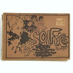
Petit solfège illustré. Illustrations de Pierre Bonnard. Deuxième mille.
30 compositions by Bonnard, mostly printed in colors, integrated with and surrounding the texts and musical passages. Publisher’s dec. boards, with full-cover illustrat...
Date: Paris, 1893
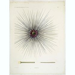
Oursins.
Decorative plate of a sea urchin, engraved by Boquet. Marie Jules César Lelorgne de Savigny (April 5, 1777 - October 5, 1851) was a French zoologist. In 1798 he traveled...
Date: Paris, 1822

De Haven en Straat von Gibraltar, Niewlyks getekend, en in`t licht gebracht door Johannes Covens en Cornelis Mortier tot Amsterdam.
Decorative map showing the siege of Gibraltar during the Spanish war of succession. This highly interesting map is richly ornated with three additional inset maps and vie...
Date: Amsterdam, 1710

Grande Pologne et Prusse avec les frontières de la Misnie, Lusace, Moravie et Lithuanie.
Detailed map of Poland and Prussia. Published by Pieter van der Aa who published a.o. "Naauwkeurge versameling der gedenkwaardigste zee- en land-reysen", a seri...
Date: Leiden, 1729

Pecheli, Xansi, Xantung, Honan, Nanking, In plaga Regni Sinensis. . .
A map of the northern provinces of China after the Jesuit Martino Martini, depicting Hebei (Pecheli), Shanxi (Xansi), Shandong (Xantung), Henan (Honan), and Jiangsu (Nank...
Date: Amsterdam, ca 1660

Histoire Socialiste.
Text includes “Imp. Centre de Propagande, des Républicains Nationaux, 102, rue Amelot, Paris (XIe), ou l’on peut se procurer cette affiche. Cette affiche ne peut êt...
Date: Paris, 1931

Kaart Van Nieuw Zeeland in de Jaaren 1769 en 1770 bezogt door den Luitenant J. Cook met het Schip De Endeavour.
A uncommon issue of this key map of New Zealand from the Dutch edition of Cook's map of New Zealand, published in 'Reize rondom de Waereld door James Cook', a Dutch editi...
Date: Leyden, Amsterdam & The Hague: Honcoop, Allart & van Cleef, 1795-1801
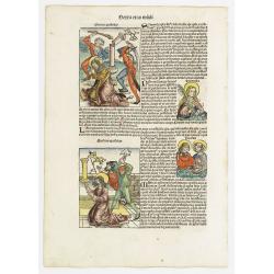
Sexta Etas Mudi. Symon Apostolus.. Folio CVII.
A very nice presentation of the martyr of Simon, sawn in half at Suanir, and Mathias stoned to death at Colchis in 80 AD. Overleaf, it shows the martyr of Matthew and Jud...
Date: Nuremberg, 12 July 1493

Kollumer land En het Nieuw Kruys land de vijfde gritenije van Oostergoo . . .
Very detailed map of "Kollumer land En het Nieuw Kruys land de vijfde gritenije van Oostergoo" in Friesland prepared by Bernardus Schotanus Steringa. Centered o...
Date: Leeuwarden, F. Halma, 1718
![[TAI travel poster]](/uploads/cache/44304-250x250.jpg)
[TAI travel poster]
A whimsical travel poster for "Transport Aeriens Intercontinentaux" (TAI), published in Paris in 1960, by Luc-Marie Bayle (1914-2000). The poster depicts a twin...
Date: Paris, 1960
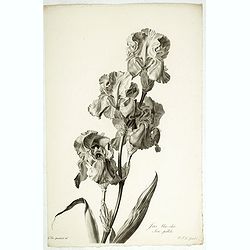
Iris bleu - clair. Iris pallida.
Dalmatian Iris or Sweet Iris, engraving by P.F. Le Grand after designs by the Dutch born Gerard van Spaendonck (1746-1822).Taken from the rare work "Fleurs dessinée...
Date: Paris, c.1800

Perspective print by Vredeman de Vries. 5
Engraving from Perspective, c'est a dire, le tresrenomme art du poinct oculaire d'une veue dedans ou travers regardante, estant sur une muraille unie, sur un tableau, ou ...
Date: The Hague, 1604 - 1605
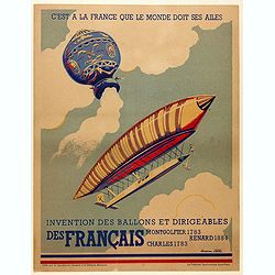
C'est à la France que le monde doit ses ailes. . .
Original poster promoting the French company Montgolfier Renard Charles, manufacture of hot air balloon and dirigibles. Full title Translation: " It is to France tha...
Date: Paris, ca. 1930

Simori.
Portrait of Simori.Von Siebold was born in Wurtzburg, in Germany, and worked for the Dutch government as a doctor in Java. In Japan, where Von Siebold arrived in 1823 at ...
Date: Leiden, 1832-1852

Imperium Russicum, cum regionibus adiacentibus duabus Tabulis ex optima quae A. 1784 tribus foliis comparavit Mappa geographica, aliisque subsidiis delineatum a C. Mannert, Tabula Ima. . .
A detailed map of the European part of the Russian Empire. Scarce map. Copper etching by C. Mannert and edited by Adam Gottlieb Schneider and Johann Christoph Weigel. Man...
Date: Nuremberg, 1794

Cust van Hollant Tussen de Maes ende Texel.
Uncommon chart of the coast of Holland, including the southern tip of Texel. East at the top. Two fine compass cards, soundings and a large Bree Veerthien offshore.Piete...
Date: Amsterdam, 1666

Siberie ou Russie Asiatique, Tartarie Chinoise, Pays des Eluts et Isles du Japon.
Map of the Kamchatka peninsula, Russian Far East., Korea, Japan, with Hokkaido labeled "Terre del Jeso".By C. F. Delamarche, successor of Robert de Vaugondy, Ge...
Date: Paris, 1794 - 1806

Gouvernement general de Champagne. . .
Fine map of Champagne with a decorative title and scale cartouche.Alexis-Hubert Jaillot (1632-1712), was a French cartographer. He joined the Sanson heirs and redrew Nico...
Date: Amsterdam, 1692
![Nankin [Nanjing, Jiangsu]](/uploads/cache/30031-250x250.jpg)
Nankin [Nanjing, Jiangsu]
Very detailed (1:1.000.000) map showing the area north of Nanjing, Jiangsu. The French Service géographique des armées was founded in 1887 and provided the French milit...
Date: Paris, 1900

20 small lithographed views of Washington DC and Georgetown.
20 small lithographed town-views of Washington DC and Georgetown, cut out from a larger sheet. Showing the East Front of the Capitol, Treasury, Smithsonian Institute, Pre...
Date: Casimir Bohn, Washington, D.C.: 1849
![[Arabia]](/uploads/cache/40143-250x250.jpg)
[Arabia]
A lovely miniature map of the region of Armenia and Georgia, showing both parts of the Black Sea and Caspian Sea. For such a small map, it renders a wealth of detail, wit...
Date: Ulm, 1692
![[ Regla columnar basalt quarry ].](/uploads/cache/27570-250x250.jpg)
[ Regla columnar basalt quarry ].
Aquatint depicting columnar basalt quarry engraved by Fumagalli. Plate N°60.This common extrusive volcanic rock is used for highway construction, railroad ballast, and t...
Date: Milan, 1827
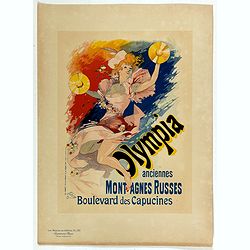
Olympia anciennes montagnes Russes.
Chromo lithographed poster, "Olympia anciennes montagnes Russes.", by CHERET, J. Plate 133, published in Maître 17, on April 1898. The "Les Maîtres de l'...
Date: Paris, Imprimerie Chaix, April 1898

Carte géologique détaillée. Râchaïya Nord.
Geological or soil map showing part of Lebanon with Râchaïya , including a legend with signs of the different geological ages and giving many informations of greatest i...
Date: Liban, Service geographique des F.F.L., 1945.
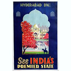
Hyderabad Dn - See Indias, premier state (Taj Mahal).
Beautiful color lithographed travel poster promoting India, more precisely the Taj Mahal.Published by Azam Steam Press Hyd. Dn.active in India.
Date: India, 1930

Kancheu.
Charming 18th water color on paper depicting Kancheu. Probably made by a western artist visiting China.
Date: c.1750
![[Too big for their bite].](/uploads/cache/45545-250x250.jpg)
[Too big for their bite].
Original vintage Soviet propaganda poster - Too big for their bite - featuring a cartoon style illustration of two men with large drooling mouths and teeth trying to cons...
Date: Russia, 1982
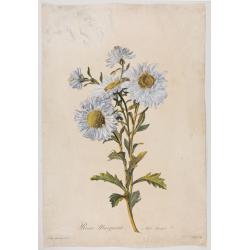
Reine-Marguerite. Aster chinensis. L.
A bouquet of flowers. Engraved by P.F. Le Grand after designs by the Dutch-born Gerard van Spaendonck (1746-1822).Taken from the rare work "Fleurs dessinées d'aprè...
Date: Paris, ca. 1800

Le comte d'Artois dresse sur les memoires les plus nouveaux. . .
Map showing the north of France, showing St Omer, and Arras, etc. The map notes Nicolas Sanson as the mapmaker and claims that the map was published by Alexis-Hubert Jail...
Date: Amsterdam, 1693

Rare collection of costume plates.
Rare collection of costume plates published in Augsburg by the famous publishers Martin Engelbrecht, Ioh. Georg Hertel and the Jeremias Wolff Heirs.Composition :2 plates ...
Date: Augsburg, ca. 1730
![[Title page] Atlante Novissimo, illustrato ed accresciuto . . .](/uploads/cache/43897-250x250.jpg)
[Title page] Atlante Novissimo, illustrato ed accresciuto . . .
Decorative Venitian frontispiece from Antonio Zatta's Atlas Atlante Novissimo, illustrato ed accresciuto . . . . The outer decoration of this title page has a wealth of c...
Date: Venice, 1785
![Canada Creek Falls . . [title in French, English, German & Latin] N°32. Pl. 4.](/uploads/cache/26800-250x250.jpg)
Canada Creek Falls . . [title in French, English, German & Latin] N°32. Pl. 4.
A view of the Canada Creek Falls.From 8e Livraison Amérique Septentrionale - Etat de New York. After Jacques Milbert and lithographed by Dupressoir and figures by V. Ada...
Date: Paris, Bove dirigée par Nöel ainé & Cie, 1892

ADSEC in Action from Thames to Rhine.
A pictorial map showing the allied movement from London on 14 March 1944 thru the conquest of Germany. Showing the track from London along Bristol, crossing the British C...
Date: London, 1945
Description geographique, historique, chronologique, politique, et physique de l'empire de la Chine et de la Tartarie chinoise.
First edition of this cornerstone of any collection of books on China, which is also among the rarest and most desirable of important Americana, included in Rare American...
Date: Paris, P. G. Le Mercier, 1735
Strabo de situ orbis.
Rare post-incunable 1502 sixth edition of Strabo’s Geographica, translated from Ancient Greek to Latin as De Situ Orbis by Guarino da Verona and Gregorio Tifernate.The ...
Date: Venice, Bartolomeo de Zanis,14th day of January 1502

Carte des découvertes fautes en 1787 dans les Mers de Chine et de Tartarie par les Frégates Françaises la Boussole et l'Astrolabe. . . ée. Feille.
La Pérouse's important large-scale of Northern Japan, Hokkaido, the Kuriles, the tip of Kamschatka, and the northern part of Korea.Showing the track of Perouse from 27 ...
Date: Paris, 1797
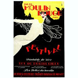
Bal du Moulin Rouge Paris - Femmes Femmes Femmes.
Poster designed by René Gruau for Bal du Moulin Rouge Paris - Festival fantaisie de rêve avec les 40 Doris Girls. Signed in the upper right-hand corner with Monogram G....
Date: Paris, Artis SA Paris, 1973
Salzbourg.
Uncommon and decorative lithography published by Carl Johan Billmark and printed by Lemercier in Paris, 55 rue de Seine, the leading firm in Europe at that time. From: It...
Date: Paris, c.1859
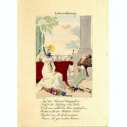
Liebeserklärung.
Engraved by Joseph Stöber, (born in Vienna 13. June 1768, died 12 March 1852) after design of Matthäus Loder (1781-1828). From Castelli, "Zerrbilder menschlicher T...
Date: Wien, 1818

Quantung, e Fokien, Provincie della China...
A beautifully engraved decorative map of Southern China extending from Hainan in the West to Formosa in the East and centered on the Pearl River Delta with Macao and the ...
Date: Venice, 1691

Carte Marine De La Mer Caspiene levée suivant les ordres de S.M.Cz. En 1719, 1720 et 1721.
Detailed of the Caspian Sea, prepared by Karl van Verden in 1722. Van Verden was a Russian sailor and the Czar's Special Commander, who produced the first accurate map of...
Date: Paris, ca. 1725
Echelle pour trouver les jours de la semaine. . . / Scale om de Dagen van de Week te vinden. . . / Scale to find the Days of the Week. . .
Fine engraved plate showing eight different scales with explications in French, Dutch and English.Scale om de dagen van de week, de verschietende feest-dagen, de maan-tyd...
Date: Amsterdam, 1695
![[ Gladiators ].](/uploads/cache/27583-250x250.jpg)
[ Gladiators ].
Aquatint depicting gladiators in combat engraved by Gallina. Plate N°73.From Giulio Ferrario's work Le Costume Ancien et Moderne ou Histoire du gouvernement, de la milic...
Date: Milan, 1827

Les Provinces des Pays Bas.
RARE. From his first edition of his only folio atlas, the map is relied upon the map of his uncle, Nicolas Sanson. Engraved by I.Somer.A nice map of Netherlands.
Date: Paris 1687
![[ Mexican traditional garments ].](/uploads/cache/27592-250x250.jpg)
[ Mexican traditional garments ].
Aquatint depicting Mexican traditional garments engraved by Gallina. Plate N°83.From Giulio Ferrario's work Le Costume Ancien et Moderne ou Histoire du gouvernement, de ...
Date: Milan, 1827
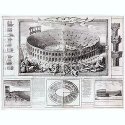
Anfiteatro detto l'Arena di Verona.
Large two sheet copper engraving of the Amphitheater of Verona after a design of Adriano Cristofali. On three sides it is surrounded by architectural details interspersed...
Date: Verona, 1744
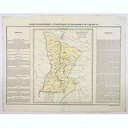
Carte Geographique, Statistique et Historique du Paraguay.
A nice detailed map of Paraguay from Buchon's Atlas Gégraphique Statistique, historique et chronologique des deux Ameriques et des isles adjacentes traduit de l'atlas ex...
Date: Paris, 1825
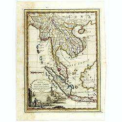
La Penisola delle Indie di la' dal Gange con parte delle Isole della Sonda delineate sulle ultima osservazioni.
First edition on laid paper. Cassini’s splendid early map of Indochina, from Bangladesh in the west to central Borneo in the east, and southern China in the north, to B...
Date: Rome, 1797
Antiquae urbis perfecta et Nova delineatio. [ Ancient Rome)
First state before imprint of Jacobus de Rubeis. A rare view of Ancient Rome from the Lafreri-School in the style of Ambrogio Brambilla's view of about 1575. A unique opp...
Date: Rome, ca. 1600
![[ Bread making ].](/uploads/cache/27591-250x250.jpg)
[ Bread making ].
Aquatint depicting a family making bread engraved by Gallina. Plate N°82.From Giulio Ferrario's work Le Costume Ancien et Moderne ou Histoire du gouvernement, de la mili...
Date: Milan, 1827

Carte nouvelle de Moscovie represente la partie Septentrionale dressée par G.De L'Isle. . .
Uncommon map covering the area north of Moscow, including Lapland. Prepared by G. de L'Isle.Joachim Ottens (1663 - 1719) and his sons Renier and Joshua were prominent Dut...
Date: Amsterdam, 1720
![Sexta Etas Mundi. Constancia. [Constance CCXLI ]](/uploads/cache/33141-250x250.jpg)
Sexta Etas Mundi. Constancia. [Constance CCXLI ]
A very fine town view of Constance, in Germany, centered on the cathedral (198 x 520 mm).VERSO, seven insets of scientists, noblemen and Popes.Page from the richest illus...
Date: Nuremberg, 12 July 1493

Carte des parties Nord et est de l'Asie..
Five maps on one sheet show the Northern Russian territories in Europe and Asia, including the western coastline from Siberia, Japan, and Korea with the island of "Q...
Date: Paris, 1779

Saint Petersbourg. Maison de bienfaisance, appartenant à Mr Anatole de Demidoff. . .
Beautiful lithography showing the house of Anatole de Demidoff in Saint Petersburg.
Date: Paris, c. 1850

Volna.
Very decorative and rare panoramic town-view of Volna. We have more Anna Beek prints available.The engraver and publisher of prints, Mrs. Anna Beek of the Hague, enlarg...
Date: The Hague, ca. 1700
![[Macaire] Abus de l'article 214 du code civil. Madame mon épouse... (Plate 50)](/uploads/cache/17389-250x250.jpg)
[Macaire] Abus de l'article 214 du code civil. Madame mon épouse... (Plate 50)
Macaire personified the clever business man, who was willing at any time to throw moral and ethical principles overboard for a quick buck. His personality fitted exactly ...
Date: Paris, 1864

Nouveau Plan Routier de la Ville et Faubourgs de Paris // Avec ses principaux Edifices et Nouvelles Barrieres.
Decorative large-scale wall map of Paris, published by M. P|chon in Paris and engraved by Michel Glot. The plan is framed by a floral border and there are 27 Parisian vie...
Date: Paris, 1834
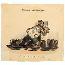
Caricature anti-cholérique La peur du mal donne le mal de la peur. (pl 1)
Caricature on hypochondria and protective measures against cholera. An overweight man seated in a chair surrounded by pitchers and bowls. In 1832, there was a devastating...
Date: Paris, ca. 1830

Chinese advertising poster for the Coat Clark British company.
This poster, an advertisement for Coat Clark, a British company from the 1930s, melds the meticulous detail of traditional Chinese painting with the craft of color lithog...
Date: Shanghai, 1950-1960
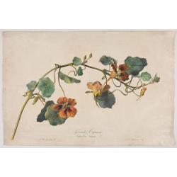
Grande Capucine Tropoeolum majus. L.
The true Nasturtium, stipple engraving by P.F. Le Grand after designs by the Dutch-born Gerard van Spaendonck (1746-1822).Taken from the rare work "Fleurs dessinées...
Date: Paris, c.1800

Australia.
Decorative steel engraved map of Australia, surrounded by illustrations of Sydney harbor, birds, kangaroos and local people. Interlocking border design. Taken from "...
Date: London, ca. 1851

Coast to Coast.
A game board that features a map of the U.S. with a built-in spinner. Players travel a circular track around the map visiting landmarks as they go. A fun way to learn geo...
Date: New York, ca. 1950

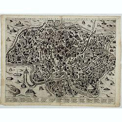
Slusa, Teutonicae Flandriae opp. . . (Sluis)
Bird'eye view of the town of Sluis.From the greatest publication in this genre!. The Civitates was compiled and written by George Braun, Canon of Cologne Cathedral. Braun...
Date: Cologne, 1580
