Popular Listings
![[Title page to] Atlas mayor, o geographia Blaviana : Que contiene las cartas, y descripciones de Partes Orientales de Europa.](/uploads/cache/29952-250x250.jpg)
[Title page to] Atlas mayor, o geographia Blaviana : Que contiene las cartas, y descripciones de Partes Orientales de Europa.
Title page from a Spanish text edition of the Atlas Major. Ionic portico with celestial and terrestrial globes. To the left is Ptolemy with a sphere and a pair of compass...
Date: Amsterdam, c.1672
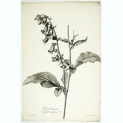
Digitale pourprée. Digitalis purpurea L.
The foxglove, engraving by P.F. Le Grand after designs by the Dutch born Gerard van Spaendonck (1746-1822).Taken from the rare work "Fleurs dessinées d'après nature....
Date: Paris, c.1800

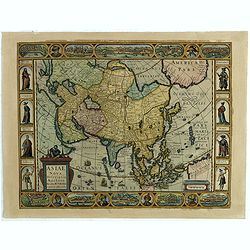
Asia By H.Moll Geographer.
Detailed map of Asia. From his "Atlas minor: or a new and curious set of sixty-two maps. . .", which was first published in 1729 and reprinted in 1732, 1736.The...
Date: London, 1736

A new & accurate map of Louisiana, with part of Florida. . .
An English view of North America compiled from available French maps, especially those of Bellin used in Charlevoix's History of New France. English cartographers had lit...
Date: London, 1744
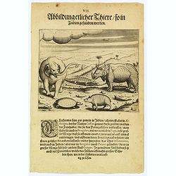
Some of the animals that are found in India.
Although most elephants are found in Ethiopia, there are also many in India too. They are called 'Caffres' by the inhabitants and are slaughtered for their tusks, which t...
Date: Frankfurt, 1598
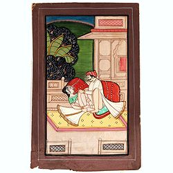
Indian erotic painting on paper.
Fine miniature, presenting a couple in a love-making position, set on a balcony within a landscape in the background. The miniature was painted in India in the late 19th ...
Date: India, ca. 1900
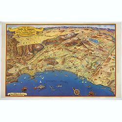
Ride the Roads to Romance along the Golden Coast and thru the Sunshine Empire of Southern California.
Published in 1950 by the Roads to Romance Association to promote tourism in California This striking touring map of Southern California was published in 1950 by the Road...
Date: California, 1950

(Art-déco gouache)
Outstanding "art deco" gouache (unsigned) from the workshop of "Robert Pichon. Ateliers de Dessin et Lithographie – 10, rue Rochechouart – Paris. The gouac...
Date: Paris, ca. 1930

P.les de Virginie.
Attractive copper engraving, depicting a couple of native people of Florida.From the French text edition of Description d'Univers, 1683. by Allain Manneson Mallet (1630-1...
Date: Paris, 1683
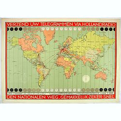
Verzend uw telegrammen via Holland Radio Den Nationalen weg. Gemakkelijk -Zeker - Snel.
Poster showing a world map in Mercator projection. In top and bottom clocks showing the time zones. Red lines connecting The Netherlands with different major hubs in Amer...
Date: The Netherlands, 1939

Vorstellung der Evangelisch-Ostindischen Kirche Augsburger Protestanten.
It is a very decorative and rare print to commemorate the 200-year Confession of the Augsburg Protestant Confession. Engraved by J. Kleinschmidt after a design of E. Ridi...
Date: Augsburg, 1732

Nouveau théâtre de la guerre entre les Russes les turcs et les polonois confédérés.
A very rare separately published map of Crime region. With a large title cartouche lower left "Nouveau theâtre de la guerre entre les russes, les turcs et les polono...
Date: Paris, 1769

Chaerte vande Wieringer waert, de welcke inden jaere XVI… (Wieringerwaard)
Rare wall map of the Wieringerwaard polder, as raffled on 12 July 1611. The polder was laid dry in 1610. It border, and the municipality's border, were the Zuiderzee, the...
Date: 1741-1744
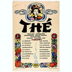
Thé Ceylan, Darjeeling, Darceyta, Chine.
Ceylon tea, Darjeeling, Darceyta, China. Advertising cardboard. Lithograph enhanced with gouache. Printed in France. King René's Illuminator.Jean Adrien Mercier, born Aug...
Date: Paris, ca 1980

Marchionatus Sacri Romani Imperii.
A wonderfully decorative map showing in the middle of the image a town plan from Antwerp and in the lower part an inset with a panoramic view of the city and harbour of A...
Date: Amsterdam, 1617- 1624

Vue du village de Maarsen en Hollande.
Showing the river Vecht at the town of Maarsen. Published by Jacques Chereau, who was a well-known publisher of optical prints, established in rue St. Jacques in Paris. I...
Date: Paris, ca. 1750

Plan de L'Isle de Paque / Plan de la Baie de Cook.
Two engraved maps and four coastal profiles of Easter Island in the Pacific. First published in the Atlas du Voyage de la Perouse. This is the edition of the extremely ra...
Date: Paris, 1797-1807
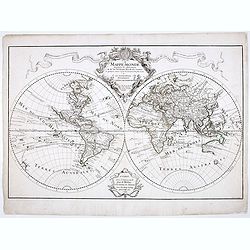
Mappe-Monde dressée sur les observations de M.rs. De L'Academie Royale des Sciences ..
Scarce and early state of the world map published c. 1707, by Delisles with the imprint "Chez l’Auteur sur le Quai de l’Horloge a la Couronne de Diamans, 1700"....
Date: Paris, 1707
Asiae Nova Descriptio.
Final State of Pieter Van Den Keere's Rare Map of Asia--The first map of Asia to include decorative panels.The map has an interesting south positioning of the Caspian Sea...
Date: Amsterdam, 1636
![Nititur ad vetitos iuuenem compellere amores Putephar, Gene[sis] 39,](/uploads/cache/47695-250x250.jpg)
Nititur ad vetitos iuuenem compellere amores Putephar, Gene[sis] 39,
A superb example of this illustration from the series of the Story of Joseph. Joseph Runs from Potiphar's Wife.Copper engraving published in " Thesaurus sacrarum his...
Date: Antwerp, 1585
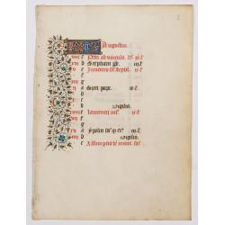
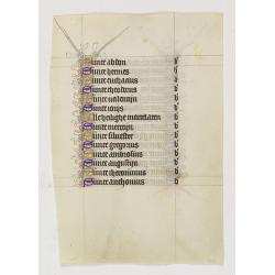
A manuscript leaf from a Book of Hours. (Calendar month of August)
RECTO : Calendar month of August with a 2-line initial in liquid gold on colored ground. colorful panel border in the left margin of acanthus leaves and flowers, with bla...
Date: Paris, ca. 1450
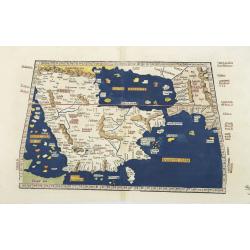
Tabula Sexta Asia (Arabian Peninsula)
This is a very desirable early Ptolemaic woodblock map of the Arabian Peninsula, here called Arabia Felix. The map is presented on a trapezoidal projection with parallel...
Date: Strassburg, 1525
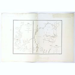
Plan du Port Jackson / Plan du Comte de Cumberland.
Two maps on one sheet showing the earliest scientific surveys of Port Jackson and the area surrounding Sydney Harbour, undertaken by the French in 1802. This is the editi...
Date: Paris, 1807
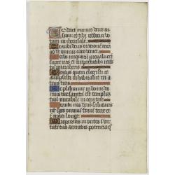
Leaf on vellum from a manuscript Book of Hours.
RECTO: One 2-lines initial decorated with flower in liquid gold on colored grounds and six 1-line initials in liquid gold on colored grounds and five line-fillers in same...
Date: France, c. 1520

Tartaria.
Published in Hondius' editions of the Mercator Atlas from 1606 onwards, China, Korea, and the northern Pacific coast of America are shown as two continents separated by t...
Date: Amsterdam, 1633

Kaerte van Bergen op Zoom, Steenbergen ende de nieuwe fortificatien gemaeckt tot bevrÿdinge van 't landt van ter Tolen in tjaar 1628.
Very detailed and scarce map showing Bergen Op Zoom, Steenbergen and its surrounding countryside. North to the left side.
Date: Amsterdam, after 1628

(Art déco gouache with winter scene of The Palace of Westminster )
Outstanding "art deco" gouache (unsigned) from the workshop of "Robert Pichon. Ateliers de Dessin et Lithographie – 10, rue Rochechouart – Paris. The goua...
Date: Paris, ca. 1930

Carte de L'Isle de Sumatra Dressee sur les Journaux des Navigateurs . . .
Detailed map of Sumatra and Malacca, centered on Singapore and including the southern portion of the Malaysian peninsula. With "Detroit de Sincapour" and severa...
Date: Paris, ca. 1750

(Island of Pearls) Perlarum insula ob unionum copiam sic dicta.
A depiction of Cubagua as the Perlarum Insula (Island of Pearls), with in the foreground, two large ships send dinghies toward busy Native Americans collecting pearl oyst...
Date: Frankfurt, 1594

Recueil de cartes géographiques pour la description de l'Indostan . . .
First French edition, the maps revised by Jean Nicholas Buache. The English original edition was published in London in 1783 by Brown under the title "Memoir of a M...
Date: Paris, Poignée, an VIII = 1800
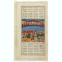
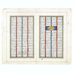
Manuscript page from a Shahnameh, The Book of Kings, written by Ferdowsi.
Page with large miniature 160 x 160mm. from the Shahnameh, or ("The Book of Kings"), which is a long epic poem written by the Persian poet Ferdowsi between c. 9...
Date: Kashmir, ca. 1830-1860

Carte du Gouvernement de Provence, suivant les nouvelles observations...
Fine copper engraved and decorative map of the Provence region in the south of France. It includes the cities of Nimes, Viviers, Avignon, Aix and Nice. The pictorial cart...
Date: Amsterdam 1728
Manuscript leaf on vellum from a Dutch Book of Hours.
A leaf from a medieval manuscript Book of Hours, written in Utrecht.Fourteen lines of monastic Textura script with fourteen 1-line initials in blue or gold with extensive...
Date: Utrecht, ca.1450 - 1460

Il vero ritratto di Nettvno al presente oaupato da gl'imperiali.
Rare and early town-plan of Nettuno, in the province of Rome, which is nowadays a touristic harbor.Issued by Joannes Orlandi who acquired many Lafreri plates, which he re...
Date: Rome, 1557 / 1602

La Saxe Contenant le Routes et les postes. . .
Fine post-route map of Saxony in Germany with a splendidly engraved title cartouche. The map is centered on Leipzig. George Louis Le Rouge was active between 1740 and 178...
Date: Paris, 1756
Selling price: ????
Please login to see price!
Sold in 2025

Asia secundum legitimas projectionis stereographicae.
Highlighted area covers part of Spain, eastern coast of Ireland to western part of Papua New Guinea and the Asian continent from the Northern Polar Sea to the Indian Ocea...
Date: Nurenberg, 1744
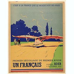
C'est à la France que le monde doit ses ailes, Clement Ader, Premier décollage du premier avion, 9 octobre 1890.
Original poster for the historical first take-off of the first plane. Translation: " It is to France that the world owes its wings, Clement Ader, First takeoff of th...
Date: Paris, ca. 1930
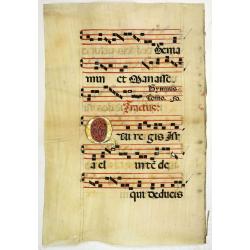
Leaf on vellum from an antiphonary.
A very fine antiphonary leaf, written in Latin , probably Rome. RECTO: The staves are in red and the notes in black. VERSO: The staves are in red and the notes in black. ...
Date: Italy, 1480

Partie de la Chine. N°.74 (Including South Korea)
Covering the Mouth of the Yangtze area in Jiangsu and Zhejiang, and southwestern Korea with the island of Quelpart (Jeju-do). Shows explorers' routes, including La Perous...
Date: Brussels, 1825-1827

L'Amerique Septentrionale.
Very rare map, from "Metaphaste Barbao, Descriptio Indiae Occidentalis et America Nova" published by Henrico Verdussen.The map is a copy of Guillaume de L'Isle'...
Date: Antwerp, 1702

L'Asie suivant les nouvelles observations...
Uncommon edition of this map of Asia. From Le Nouveau Theatre du Monde, ou la Geographie Royale.The map is of interest for the use of Mer Orientale, the sea between Kore...
Date: Amsterdam, 1728
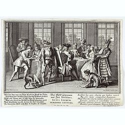
Lusus Lucrum Temporis Iactura.
Copper-plate engraving showing a group of fashionably dressed men and women playing cards. "Paulus Decker inv. et del.; Ioh. Christoph Steudner sculp.; Mart. Engelbr...
Date: Augsburg, 1700
![[Title page from ] Le Theatre du Monde ou Nouvel Atlas . . .](/uploads/cache/45053-250x250.jpg)
[Title page from ] Le Theatre du Monde ou Nouvel Atlas . . .
A very decorative frontispiece by Willem Blaeu from the second part of this fine atlas. At top, a coat of arms surmounted by a crown and surrounded by two golden chains, ...
Date: Amsterdam, 1644
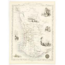
Western Australia. Swan River.
Decorative steel engraved map of part of Western Australia and Swan River, surrounded by illustrations of Perth, Aborigines and sheep shearing. With the seal of Western A...
Date: London, ca. 1851

Prospectus veteris castelli Graviae.
One of the earliest views of the ancient Castle of Grave. Engraved by Casper Bouttats. With a description in Latin, French and Dutch.
Date: Amsterdam, 1695

Nieuwe Kaart van de Westfaalse Kreits..
Isaac Tirion was born in Utrecht ca. 1705. He came to Amsterdam ca. 1725. Tirion published a number of important books, many of which are still in demand for their intere...
Date: Amsterdam, 1745
![Chinese advertising poster [ Liae divison public specialized into the middle age of China.]](/uploads/cache/45085-250x250.jpg)
Chinese advertising poster [ Liae divison public specialized into the middle age of China.]
This poster, an advertisement from the 1930s, melds the meticulous detail of traditional Chinese painting with the craft of color lithography. It depicts a beautiful woma...
Date: Shanghai, 1950-1960

Carte d'Asie divisée en ses principaux Etats.
Uncommon and decorative "carte à figures" - wall map, prepared by Clouet, with superb decoration, including a wonderful rococo border with 20 decorative vignett...
Date: Paris, Mondhare, 1787

Nouvelle et exacte Carte du Duche de Brabant. . .
A very rare example of a map of the Duchy of Brabant. Title cartouche in the lower left-hand corner. A very rare issue of this map of Brabant. Cornelis Danckerts II. copi...
Date: Amsterdam, 1635
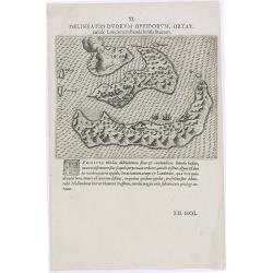
Delineatio Duorum Oppidorum, Ortat.
Early map of the Banda Islands.Theodore de Bry, a German engraver and book dealer, began a compilation of early voyages in 1590 and had published six parts at the time of...
Date: Frankfurt, 1609
Selling price: ????
Please login to see price!
Sold in 2025

L'Arabie.
Small detailed map of the Arabian Peninsula. From Atlas Portatif Universel, by Robert de Vaugondy.Page 162 outside border top right.
Date: Paris, later than 1749

Steel compass with a gilded radiating pattern.
Steel compass with a gilded radiating pattern.Provenance : Collection Henri-Claude Randier.
Date: ca. 1760

Provincie Noord-Braband. / Breda, de Langstraat. . .
Decorative and uncommon custume plate lithographed by R. de Vries and published by Frans Buffa & Zonen in Amsterdam. A group of 4 women from the area of Baronie van B...
Date: Amsterdam, 1857
![[ Spitzbergen ]](/uploads/cache/27541-250x250.jpg)
[ Spitzbergen ]
Two aquatints depicting the northern coasts of the Spitzbergen engraved by Fumagalli. From Giulio Ferrario's work Le Costume Ancien et Moderne ou Histoire du gouvernemen...
Date: Milan, 1827

Noordoost Cust van Asia van Japan tot Nova Zembla.
Important for its early depiction of Hokkaido and the Islands to the North of Japan. Ships navigate the seas around the Siberian, Chinese and Japanese coast extending as ...
Date: Amsterdam, 1666
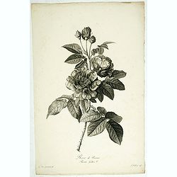
Rose de Provins. Rosa Gallica.
Bouquet of roses, stipple engraving by J.Godefroy after designs by the Dutch born Gerard van Spaendonck (1746-1822).Taken from the rare work "Fleurs dessinées d'aprè...
Date: Paris, c.1800

Carte du Palatinat du Rhin.
Decorative "carte à figures"- map centered on Koblenz, Metz, Strasburg, Manheim and Heidelberg, with the river Rhine by François Jollain (ca. 1641 – 18 April 17...
Date: Paris, ca. 1688
Il Regno Di Candia.
This rare map is based on the important map of Crete by Basilicata. The maps by Marco Boschini reached a wider audience than the few individuals for whom the Basilicata m...
Date: Venice, 1660

Malte Vue prise de la Mer. - Malta Vista lomada del mar.
Very decorative view of the Grand Harbour of Malta by Louis Lebreton, published in "Ports de Mer d’Europe" in 1859 by L. Turgis in Paris.This lithography shows ...
Date: Paris, Turgis, 1859

s'Lands en Oost-Indische Lynbanen. & t'Oost-Indisch-Huys.
A decorative print of the Lynbanen a place were V.O.C. ship riggings and ropes were produced and kept.
Date: Amsterdam, 1760-1767
A Newe mape of Poland Done into English by I.Speede.
A wonderful map of Poland. Incorporated into Speed's 'Prospect Of The Most Famous Parts Of The World'. Includes birds-eye views of Cracow, Dantzick, Posna, Crossen, Sando...
Date: London, 1627

Le Cours de l'Elbe et de l'Oder où sont les Electorats de Saxe et de Brandebourg, les Duchés de Mekelbourg et de Pomeranie. . .
A detailed and scarce map showing the rivers Elbe and Oder in Germany and Poland. Dark engraving.This is one sheet of the four sheet wall map by Pierre Du Val entitled: &...
Date: Paris, 1684

Géographie des Plantes Equinoxiales - Tableau physique des Andes et pays voisins. . .
Physical Portrait of the Andes and adjacent lands", organized around the Chimborazo and Cotopaxi volcanoes in Ecuador.With local vegetation is illustrated pictoriall...
Date: Paris, 1805
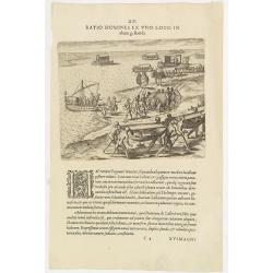
XV. Ratio Homines Ex Uno Loco In alium gestandi.
Scene in the kingdom of Pegu, now Myanmar, showing elephant, ships and locals.Theodore de Bry, a German engraver and book dealer, began a compilation of early voyages in ...
Date: Frankfurt, 1599
Atlas usuel de Géographie Moderne…
Complete with title page, contents page, and all 32 double-page maps of European and regional maps of the world, including Oceania, the Americas, Asia, Africa, etc. All i...
Date: Paris, c. 1865
Selling price: ????
Please login to see price!
Sold in 2024
Double page manuscript page from a Shahnameh, The Book of Kings, written by Ferdowsi.
Fine double page brilliantly illuminated gilt leaves written by the scribe Abu Bakr Jami in Isfahan. The Arabic text contains Islamic prayers with beautiful headings thro...
Date: Isfahan, ca. 1780

Carte des pavillons accompagnée d'observations pour en faire comprendre le blazon et les différentes devises aussy bien que d'une table alphabétique pour les trouver facilement.?
Map of 88 marine flags, including Malta, Turkey, Middelburg, Amsterdam, Portugal, Monaco, Tuscany, China, Nanking, the French Royal flag, French admiralty flag and mercha...
Date: Amsterdam, 1720
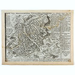
Novae Urbis Hierosolymitanae topographica delineatio . . .
A very rare plan of modern Jerusalem oriented to the east, according to a note on the map the map was drawn after a map by Peter Laicstain. A lettered key to the right.Up...
Date: Antwerp, 1571

Un Reclutatore in India. Papagallo No. 42. Anno VI.
A British recruter in India. Design by Augusto Grossi. Taken from the Italian satirical newspaper Il Papagallo, a satirical magazine founded in January 1873 by Augusto Gr...
Date: Bologne, 1878
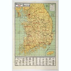
The Road Map of Southern Korea.
Offset printing. A large scale, comprehensive road map of South Korea, with a symbol legend and an inset map of 'The Republic of Korea', and inset of the island of Jeju D...
Date: Seoul, ca 1960

Porte de Harlem (Heemstede/Haarlem)
Showing the Haarlemmer Poort (gate) in Heemstede near Haarlem. Likely published by Mondhard, who was a well-known publisher of optical prints, established in rue St.Marti...
Date: Paris, ca. 1750
Kasteel Heeswijk.
Very fine etching of the Castle of Heeswijk, by the well-known etcher Ludwig Willem Reymert Wenckebach. He was born in The Hague on 12 January 1860 and died in 1937. The ...
Date: Amsterdam, 1901

Kasteel Croij.
Decorative lithography of the castle of Croij.
Date: Den Haag, 1880
![Le Isole di Sandwich delineate sulle osservazioni del Cap Cook. [Hawaii]](/uploads/cache/43195-250x250.jpg)
Le Isole di Sandwich delineate sulle osservazioni del Cap Cook. [Hawaii]
FIRST EDITION on laid paper. Cassini’s splendid map depicts the Sandwich Islands, the old name for the Hawaiian Islands, at the end of the eighteenth century. The splendi...
Date: Rome, 1798
![[Title cartouche from Carte de la France]](/uploads/cache/47726-250x250.jpg)
[Title cartouche from Carte de la France]
Title cartouche from "Carte de la France", prepared by Captaine and published by Pierre D. Belleyme.
Date: Paris, ca. 1789
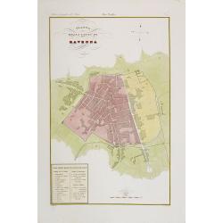
Pianta della citta di Ravenna.
Very finely engraved and detailed plan of Ravenna. Engraved by V.Angeli and included in: Atlante Geografico dell Italia. To the lower left a key to the principal building...
Date: Rome, 1860
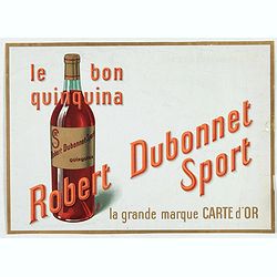
Le bon Quinquina - Robert Dubonnet Sport.
Advertising lithographed poster for Le bon Quinquina - Robert Dubonnet Sport.
Date: Paris, between 1925 and 1930

Karte von Katay od. dem Reiche Kin, zur Geschichte von Jenghiz Khan. Aus dem Englischen.
The map is of interest for the use of East Sea, the sea between Korea and Japan, here called "Meer von Corea".Copper engraving, hand colored in outline and wash...
Date: Leipzig, Schwabe, ca. 1750
![[Map of Corfu. View of the city of Corfu on the foreground. ]](/uploads/cache/45221-250x250.jpg)
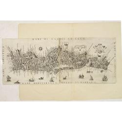
[Map of Corfu. View of the city of Corfu on the foreground. ]
Very rare map of Corfu with a view of the city of Corfu on the foreground. Published in the first edition of "Viaggio da Venetia, a Costantinopoli. Per Mare, e per T...
Date: Venice, Giacomo Franco, 1598
A leaf from a breviary.
Two large 2-line initials in red and or blue for the start of the new chapter.Nice clean leaves, with ample margins, from a breviary, end of the 15th. century.
Date: Northern Netherlands ?, ca. 1480
