Browse Listings
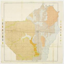
![[Soil map] Virginia-Maryland-West Virginia, Leesburg sheet.](/uploads/cache/23257-250x250.jpg)
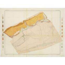
[Soil map] Virginia-Maryland-West Virginia, Leesburg sheet.
Early color lithographed soil map by Julius Bien & Co. in New York for Department of Agriculture. Legends at side give detail on soil type, etc. They also include int...
Date: New York, 1903
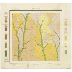
Soil map - Pennsylvania, Lockhaven sheet.
Early color lithographed soil map by Julius Bien & Co. in New York for Department of Agriculture. Legends at side give detail on soil type, etc. They also include int...
- $50 / ≈ €43
Date: New York, 1903
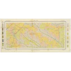
Soil map - Texas, Nacogdoches sheet.
Early color lithographed soil map by Julius Bien & Co. in New York for Department of Agriculture. Legends at side give detail on soil type, etc. They also include int...
- $75 / ≈ €65
Date: New York, 1903
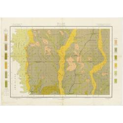
Soil map - Georgia, Fort Valley sheet.
Early color lithographed soil map by Julius Bien & Co. in New York for Department of Agriculture. Legends at side give detail on soil type, etc. They also include in...
- $50 / ≈ €43
Date: New York, 1903
Soil map - Mississippi, McNeill sheet.
Soil map printed by Julius Bien & Co in New York for Department of Agriculture. The map is giving great detail of the area McNeill, Mississippi, in the year 1903. Soi...
- $50 / ≈ €43
Date: New York, 1903
Soil map - Louisiana, Ouachita sheet.
Early color lithographed soil map by Julius Bien & Co. in New York for Department of Agriculture. Legends at side give detail on soil type, etc. They also include int...
- $40 / ≈ €34
Date: New York, 1903
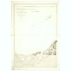
![Wusung River or Hwang Pu. / Wusung River Entrance [With Shanhhai]](/uploads/cache/48595-250x250.jpg)
Wusung River or Hwang Pu. / Wusung River Entrance [With Shanhhai]
A fine Survey chart no. 1601 showing Wusung River or Hwang Pu. / Wusung River Entrance [With Shanghai]
- $800 / ≈ €689
Date: London, 1887 - 190, updated to 1903

CANTON Kong-Teheou.
Very detailed (1:1.000.000) map centered on Macao and Victoria Island, showing soundings, English, Australian, Danish telegraph lines reaching Hong Kong and extended to M...
Date: Paris, 1898 updated for june 1904
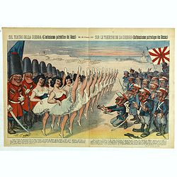
Sul teatro della guerra (L'entusiasmo patriottico dei Russi) - Rana N. 10 (Cent.10) - Sur le théâtre de la guerre (enthousiasme patriotique des Russes).
Satirical depiction of the Russo-Japanese war, which began in February 1904,we can see the opposed armies of the Russian and those of the Japanese Empire for the control ...
Date: Bologna, 11 March 1904
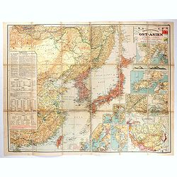
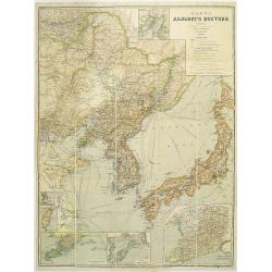
Übersichtskarte von Ost-Asien im Maßstabe 1: 5.000.000 mit 14 Beikarten in großen Maßstäben . . .
A large, uncommon map of East Asia prepared by Karl Peucker, and published by Ataria & Co. Striking and heavily annotated with information on China, Korea, Japan, and...
Date: Vienna, Artaria, 1904
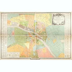
Plan des paroisses de Paris avec la distinction des parties éparses qui en dépendent dressé... par J. Junié, Ingén. Géogr. De Monseigneur l'Archeveque et géomètre des Eaux et forêts de ...
Large wall map size plan of Paris in 4 separate sheets, if joined forming a plan of Paris of 93 x 60cm. This plan is a 1904 version of a manuscript plan drawn in 1786 by ...
Date: Paris, Service des Travaux historiques de la Ville de Paris, 1904
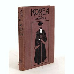
Korea. Das Land des Morgenrots. Nach seinen Reisen geschildert von Angus Hamilton. Autorisierte Übersetzung aus dem Englischen.
With 114 illustrations after photographes and one map.
- $175 / ≈ €151
Date: Leipzig: Spamer, 1904

A Humorous Diplomatic Atlas of Europe and Asia. / 滑稽欧亜外交地図 / Kokkei Ō-A Gaikō Chizu.
A wonderful example of the rare 1904 Kisaburo Ohara satirical 'Octopus Map' of Europe being swallowed by an octopus (Russia). Composed at the outbreak of the Russo-Japane...
Date: Tokyo, April, 1904
Map of the Far East
rare map including, Corea, Japan and China, prepared by Leonid Ivanovich Borodovsky, (1870-1906) and published in 1904. This folding map has several insets, one with Tai...
- $1000 / ≈ €861
Date: St. Petersburg, A.Ilyin, 1904

Excelsiori (Rana N. 28 - Cent. 20).
"After so many wars and so many troubles, young Russia, in a more serene glaze all the beautiful sun of freedom you will enjoy ... ". Fascinating allegorical sa...
Date: Bologna, 1905
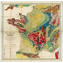
Carte géologique de la France.
Early geological map of France, published by Charles Béranger. Full title: " Ministère des Travaux publics, Carte géologique de la France 1:1'000'000, Exécutée ...
- $1200 / ≈ €1033
Date: Paris, 1905
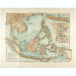
Hinterindien und Malayischer Archipel.
Map of South East Asia with four insets. Shows settlements, roads, railways, telegraph cables, etc. A color key to Dutch, French, British, and Portuguese occupations. Inc...
Date: Leipzig, 1905
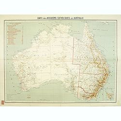
Carte des missions Catholiques en Australie.
Rare and detailed map of Australia (Scale 1:5 000 000) showing Catholic dioceses and bishops' residences, but not missions, on a topographic basis. Relief is shown by hac...
Date: Lyon / Paris, 1906

L'illustration, journal officiel hebdomadaire.
L'Illustration, the first French illustrated newspaper from 1843, became the first magazine in the world in 1906 and is distributed in more than 150 countries.The mythica...
Date: Paris, 1908
![Manila the perl of the Orient. Guide book to the intending visitor [with several photos and 3 plans of Manila]](/uploads/cache/48356-250x250.jpg)
Manila the perl of the Orient. Guide book to the intending visitor [with several photos and 3 plans of Manila]
Charming 1908 Guide book to with several photos and 3 folding plans of Manilla. Published by the "Manila merchants' association", directed by O'Connell, Daniel....
Date: Manilla, 1908
![Karta Evropeiskoi Rossii i Sibirii na 4 listakh [ Map of European Russia and Siberia in 4 sheets compiled and based on the most advanced statistical and geographical information.]](/uploads/cache/43927-250x250.jpg)
Karta Evropeiskoi Rossii i Sibirii na 4 listakh [ Map of European Russia and Siberia in 4 sheets compiled and based on the most advanced statistical and geographical information.]
A fine large map showing Eastern Europe from Stockholm to Constantinople, with Russia eastward from Perm and south to the Caucasus and Iran. With indications of judicial ...
- $750 / ≈ €646
Date: Saint Petersburg, 1908
![[Tartary - Russia]](/uploads/cache/44310-250x250.jpg)
[Tartary - Russia]
Postcard size map in Ottoman script showing Siberia prepared by Mehmet EŞREF in a small atlas : عمومولاياةىشهانيىحاوىكوچكاطلاس [Umum-i vil...
Date: Istanbul, 1325 or 1909
![[Australia and New Zealand map with Ottoman script.]](/uploads/cache/44313-250x250.jpg)
[Australia and New Zealand map with Ottoman script.]
Post card size map in Ottoman script showing Australia and New Zealand prepared by Mehmet EŞREF in a small atlas : عمومولاياةىشهانيىحاوىكوچكا�...
Date: Istanbul, 1325 or 1909
![[United States map with Ottoman script.]](/uploads/cache/44314-250x250.jpg)
[United States map with Ottoman script.]
Postcard-size map in Ottoman script showing the United States, prepared by Mehmet EŞREF in a small atlas: عمومولاياةىشهانيىحاوىكوچكاطلاس [...
Date: Istanbul, 1325 or 1909
![[Persia, Afghanistan and Pakistan map with Ottoman script]](/uploads/cache/44316-250x250.jpg)
[Persia, Afghanistan and Pakistan map with Ottoman script]
Postcard size map in Ottoman script showing Persia, Afghanistan and Pakistan prepared by Mehmet EŞREF in a small atlas : عمومولاياةىشهانيىحاوىكو�...
Date: Istanbul, 1325 or 1909
![[Asia map with Ottoman script]](/uploads/cache/44317-250x250.jpg)
[Asia map with Ottoman script]
Postcard size map in Ottoman script showing Asia, prepared by Mehmet EŞREF in a small atlas : عمومولاياةىشهانيىحاوىكوچكاطلاس [Umum-i vilay...
Date: Istanbul, 1325 or 1909
![[Australia, New Zealand and Oceania map with Ottoman script]](/uploads/cache/44319-250x250.jpg)
[Australia, New Zealand and Oceania map with Ottoman script]
Postcard size map in Ottoman script showing Australia, New Zealand and Oceania prepared by Mehmet EŞREF in a small atlas : عمومولاياةىشهانيىحاوىك�...
Date: Istanbul, 1325 or 1909
![[World map in showing currents with Ottoman script]](/uploads/cache/44322-250x250.jpg)
[World map in showing currents with Ottoman script]
Post card size world map in Mercator projection showing the currents in Atlantic and Pacific Oceans in Ottoman script prepared by Mehmet EŞREF in a small atlas : عمو...
Date: Istanbul, 1325 or 1909
![[Set of two maps showing world in Mercator projection, with Ottoman script]](/uploads/cache/44328-250x250.jpg)
[Set of two maps showing world in Mercator projection, with Ottoman script]
Two postcard size maps showing the entire world in Mercator projection. The maps are in Ottoman script prepared by Mehmet EŞREF in a small atlas : عمومولاياة�...
Date: Istanbul, 1325 or 1909
![[ North and South America with telegraph cables, with Ottoman script]](/uploads/cache/44330-250x250.jpg)
[ North and South America with telegraph cables, with Ottoman script]
Postcard size map showing North and South America with telegraph cables. The map is in Ottoman Arabic-script prepared by Mehmet EŞREF in a small atlas : عمومولا�...
Date: Istanbul, 1325 or 1909
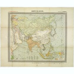
General Karte von Asien. Entworfen und gezeichnet von F. Handtke.
In upper left corner "Carl Flemmings Generalkarten No. / Nr. 37" in a 17th edition. Prepared by Friedrich Handtke (1815-1879). Scale 1: 18.886.000, with a key i...
Date: Glogau, Carl Flemming, c.1910
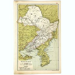
Manchuria.
Map of Manchuria and Korea. With in lower left corner scales in miles and kilometers, Protestant Mission Stations, railways both opened and in progress, canals and telegr...
- $75 / ≈ €65
Date: London, 1910
![[Set of six postcards] La Comète 1910 / Komet 1910.](/uploads/cache/44401-250x250.jpg)
[Set of six postcards] La Comète 1910 / Komet 1910.
Complete set of six postcards commemorating Halley's Comet in 1910. Numbered on verso 1 to 6, Verlag Koch & Bitriol Serie 3090 Bild 6 AK. Designed by K. Hesse. The ye...
Date: Dresden, Koch & Britriol, 1910
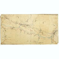
Boucle du Pei-Ho.
Manuscript map of Boucle du Pei-Ho (Taku Forts) showing the river Pei-ho, along with the projected railway lines were to be built, including bridges, installations, villa...
- $750 / ≈ €646
Date: China ?, ca.1910

Atlas Geographique. (Puzzle).
Three map puzzles, each measuring 25 x 33 cm., housed in the original color printed card case. Geographical jigsaw puzzle set comprising three maps (world, Europe and Fra...
Date: Paris, ca. 1910
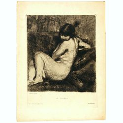
Le Turban.
Etching in brown ink on cream laid paper by Albert Besnard (1849–1934) of a young naked woman with feathered turban. Inscribed below the borderline: (left) “A. Besnar...
Date: Paris, 1910
![[Game of the goose] Het apenspel.](/uploads/cache/48333-250x250.jpg)
[Game of the goose] Het apenspel.
Game of 73 boxes, spiral, counter clockwise. Goose board game. Outside the board images of monkeys. More about game boards and goose games. [+]
- $120 / ≈ €103
Date: Amsterdam, Senefelder, ca. 1890-1910
![[Game of the goose] Nieuw vermakelijk Ganzenspel.](/uploads/cache/48338-250x250.jpg)
[Game of the goose] Nieuw vermakelijk Ganzenspel.
Goose board game. Oval with boxes numbered from 1 to 63. Every box shows an image of a person, a goose, a building or dice. In the middle a large oval with a goose. Child...
- $150 / ≈ €129
Date: Weisenburg, ca.1910
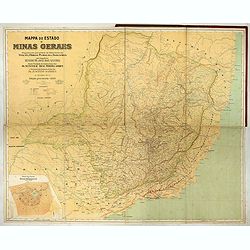
Mappa do estado de Minas Geraes.
Monumental map of the Minas Geraes State, the Brazilian Eldorado, with an inset plan of Belo Horizonte. Scale of 1 : 100 000. Lith. Hartmann-Reichenbach, 1910. Organized ...
- $1000 / ≈ €861
Date: Rio de Janeiro, 1910 -1911

Nuevo plano de la ciudad de Buenos Aires y parte del partido de avellaneda . . .
A rare detailed city plan of Buenos Aires prepared in 1912 by Ernesto Escalante. The plan depicts the city from the Partido de Avellaneda and the Villa Riachuelo to the R...
Date: Buenos Aires, 1912
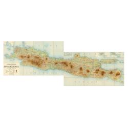
Overzichtskaart van Java en Madoera schaal 1:500.000. Met aanduiding van de politieke indeeling, de organisatie van het bestuur, de bestaande en nog aan te leggen verkeerswegen en van de groote cultuur- en industrieele centra…
If assembled a very large color-printed map (60x 218cm.) of Java and Madoera (Madura Island) on four sheets, each measuring 60 x 54.5 cm, dissected into 12 sections and l...
Date: Atelier Kurkdjian-Soerabaia, 1912
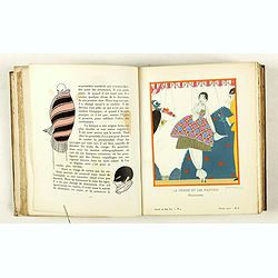
Gazette du Bon Ton Art - Modes Frivolités. (1912/1913 volume)
La Gazette du Bon Ton was a leading French fashion magazine that was published from November 1912 to 1925. The extremely rich and vivid colors were achieved through the l...
Date: Paris, 1912-1913
Carte particuliere de la cote septentrionale d'Afrique. (13eme feuille)
A fine French Service Hydrograhique de la Marine chart no. 3424, showing Cape Rose and Cap Nègre, in Algeria, drawn in 1873 by E. Mouchez, updated to 1913. Chart engrave...
- $80 / ≈ €69
Date: Paris, 1873 / 1913

Pl. 8. - Robe à la Circassienne.
From Galerie des modes et costumes français dessinés d'après nature 1778-1787. Réimpression accompagnée d'une préface par M. Paul Cornu.Beautiful reissue done by th...
- $50 / ≈ €43
Date: Paris, 1912-1914
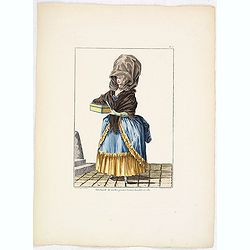
Pl. 5. - Marchande de modes.
From Galerie des modes et costumes français dessinés d'après nature 1778-1787. Réimpression accompagnée d'une préface par M. Paul Cornu.Beautiful reissue done by th...
- $50 / ≈ €43
Date: Paris, 1912-1914
(Design for Hark ! Hark ! The dogs do bark.)
This very rare political caricature map of Europe depicts the continent at the outbreak of World War I, or as it was called at the time the Great War. The principal count...
- $3000 / ≈ €2583
Date: London, ca. 1914
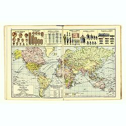
The Royal Primrose Atlas. 'A Complete Desk Companion & Blotter Combining The Most Interesting And Up-To-Date Maps ...
Contains 17 maps, an introduction plus various diagrams and statistics throughout. End pages consist of promotional material for John Knight Ltd. (Est. 1817) Manufacturer...
Date: London, ca. 1914
Planisphère terrestre.
A huge (2 meters) world map representing Asia and America in the center, Europe and Africa at left and right hand of the map. Published by the Service hydrographique in 1...
- $800 / ≈ €689
Date: Paris, Service hydrographique, 1902-1914
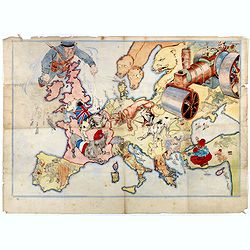
Humoristische Karte von Europa im Jahre 1914.
A satirical map of Europe with a title in German that marks the outbreak of the First World War, probably conceived between August and October 1914. Lehmann-Dumont was no...
Date: Dresde, Leutert & Schneidewind, ca. 1914
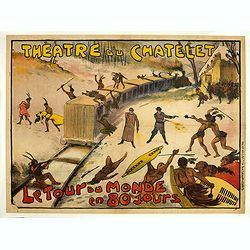
Théâtre du Châtelet. Le Tour du Monde en 80 jours. (The attack of the train).
Theatre poster for "Around the World in Eighty Days by A. Dennery and Jules Verne, for Théâtre du Châtelet, Paris. Printed by : Imprimerie Ch. Wall et Cie, 14 rue...
- $1200 / ≈ €1033
Date: Paris, Imp. Ch. Wall et Cie, ca.1900-1914
![[Goose game board] Le 1914 Edition pochette.](/uploads/cache/47214-250x250.jpg)
[Goose game board] Le 1914 Edition pochette.
Goose game in the form of a folding map of north of France and Belgium, with part of England, Germany, Holland and Luxembourg.More about board games [+]
Date: Paris, 1914
![[Goose game board] Le 1914 Edition pochette.](/uploads/cache/47215-250x250.jpg)
[Goose game board] Le 1914 Edition pochette.
Goose game in the form of a folding map of north of France and Belgium, with part of England, Germany, Holland and Luxembourg.
- $450 / ≈ €387
Date: Paris, 1914
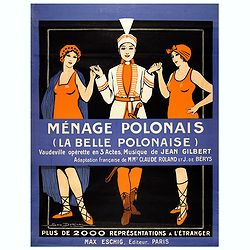
Ménage Polonais (La belle Polonaise) - Vaudeville opérette en 3 actes. Musique de Jean Gilbert.
Original advertising poster for the operetta " Ménage Polonais ". Title translation " Polish household " Ménage Polonais (The beautiful Polish) - Va...
Date: Paris, 1914

Mappa Humoristico da Europa.
A really unusual and lovely map, published in Portugal at the outbreak of The Great War in 1914. This outbreak of war in Europe was the result of a complex sequence of ev...
Date: Lisbon, 1914

Hark ! Hark ! The dogs do bark.
This scarce political caricature map of Europe depicts the continent at the outbreak of World War I, or as it was called at the time, the Great War. Designed by Johnson, ...
Date: London, Johnson Riddle & Co.,1914

Karte von Europa im Jahre 1870 nach einem französischen Holzschnitte.
Satirical illustration by Paul Hadol showing disposition of power in Europe at the beginning of 1870. Satirical print depicting a map of Europe in which the countries are...
Date: Hamburg, Fuchs, 1914
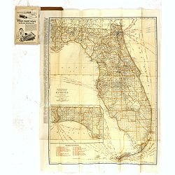
Rand Mc.Nally indexed pocket map Tourits' and Shipper' Guide of Florida. . .
This fine pocket map has on both side a map of Florida. Folding color map (approximately 640 x 495mm) is titled "Rand McNally standard map of Florida" and one h...
Date: Chicago & New York, ca.1915

Völker Europas wie schön sind eure Geschichter. (World War I post card)
During the Great War, when the only means of communicating news to the masses was by newspapers and weekly illustrated magazines, the ‘war’ or 'military' picture post...
Date: Germany, 1915
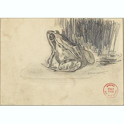
A frog sitting on a water lily leaf
A frog sitting on a water lily leaf. With round red stamp "Atelier Jan van Oort 1867-1938".
- $90 / ≈ €77
Date: Geldrop, 1915
![[Cloth Map of Europe]](/uploads/cache/47148-250x250.jpg)
[Cloth Map of Europe]
Anglo-centric cloth map of Europe produced during WWI.Serbia, the spark that lit the conflagration of World War One, isn’t even labeled on this interesting cloth map of...
Date: London, c. 1915

A very early large London Underground enamel station sign for Westerminster Station
This large enamel sign can be dated between 1908 and 1915, when the bull’s-eye design, a solid red disk with a horizontal bar containing the text, was adopted by all th...
- $22000 / ≈ €18941
Date: London, ca. 1908-1915
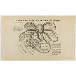
L'Impero della preda ossia la Piovra d'Absburgo.
Austro-Hungarian Octopus zinc lithographed map. A propaganda sheet attacking the Austro-Hungarian Empire, showing it as an octopus with its tentacles wrapped around the v...
Date: La Zincografia, Milan, c. 1915
![[Map of Turkey in Ottoman script]](/uploads/cache/40765-250x250.jpg)
[Map of Turkey in Ottoman script]
Map of Turkey, including Cyprus, with text in Ottoman script. In the bottom a color key to the different regions. Published by Elbemühl Graphische Industrie in Vienna (f...
Date: Vienna, ca. 1915
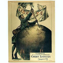
3e emprunt de la Défense nationale Crédit Lyonnais. Souscrivez.
Large color lithographed propaganda World War 1 poster. Designed by the illustrator Faivre Abel (1867-1945). A solder placing the French flag on a globe.English translati...
Date: Paris, 1917
![[Lot of Five Pacific Brand crate labels]](/uploads/cache/45706-250x250.jpg)
[Lot of Five Pacific Brand crate labels]
Five fruit crate label for Pacific Brand, showing a lemon and a map of the Pacific Ocean, centered on Hawaii and including a part of California and Asia, with also Austra...
Date: Santa Barbara, 1917
![[2 maps] Das Europa der Zukunft... / Das heutige Europa…[The Europe of the Future / The Europe of Today]](/uploads/cache/48735-250x250.jpg)
[2 maps] Das Europa der Zukunft... / Das heutige Europa…[The Europe of the Future / The Europe of Today]
A pair of very scarce WWI German maps highlighting Europe as it currently was, and Europe as it may become. The maps were produced as part of an 8 page booklet produced b...
- $2750 / ≈ €2368
Date: Paris, 1917

Mapa Polski i Krajów Osciennych - Wydanie trzecie. Opracowal Stanislaw Max. Wydani M. Arcta.
‘The Birth of Modern Poland on a map’ - an excellent wall map of Poland and surrounding regions, published in Warsaw near the end of World War I, when Poland’s fate...
Date: Warsaw, [H. Sklodowski], 1918

Guaranty Trust Company of New York. Emprunt national 6%.n Souscrivez.
Very decorative propaganda poster with design by Mark All of Paris for "Guaranty Trust Company of New York", a JPMorgan Chase predecessor in order to promote th...
Date: Paris, 1918
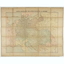
Carte populaire des opérations de la guerre. 2ème édition.
Folding map. War Operations Map showing a part of Europe, published by Epinal.
Date: Paris, ca. 1919
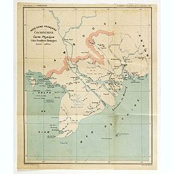
Indo-Chine Française Cochinchine. Carte Physique Côtes, Frontières, Montagnes.
Charming map of the southern third of current Vietnam whose principal city is Saigon or Prey Nokor in Khmer. It was a French colony from 1862 to 1954.Prepared by R.Brissa...
- $150 / ≈ €129
Date: Saigon, Librairie Brunet. c.1920
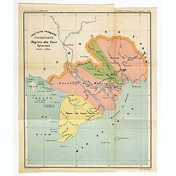
Indo-Chine Française Cochinchine. Régime des Eaux Réseaux.
Charming map of the southern third of current Vietnam whose principal city is Saigon or Prey Nokor in Khmer. It was a French colony from 1862 to 1954.Prepared by R.Brissa...
- $150 / ≈ €129
Date: Saigon, Librairie Brunet. c.1920
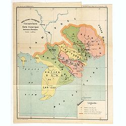
Indo-Chine Française Cochinchine. Carte historique Anciennes Provinces.
Charming map of the southern third of current Vietnam whose principal city is Saigon or Prey Nokor in Khmer. It was a French colony from 1862 to 1954.Prepared by R.Brissa...
- $150 / ≈ €129
Date: Saigon, Librairie Brunet. c.1920
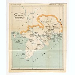
Indo-Chine Française Cochinchine. Productions du Sol Commerce, Industrie.
Charming map of the southern third of current Vietnam whose principal city is Saigon or Prey Nokor in Khmer. It was a French colony from 1862 to 1954.Prepared by R.Brissa...
- $150 / ≈ €129
Date: Saigon, Librairie Brunet. c.1920
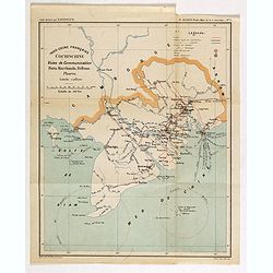
Indo-Chine Française Cochinchine. Voies de Communication Ports Marchants, Défense Phares.
Charming map of the southern third of current Vietnam whose principal city is Saigon or Prey Nokor in Khmer. It was a French colony from 1862 to 1954.Prepared by R.Brissa...
- $150 / ≈ €129
Date: Saigon, Librairie Brunet. c.1920

Chemin de fer de l'est - Luxeuil les Bains vers 1920.
Vintage Railway Travel Poster - Luxeuil les Bains, for the department Haute-Saône. Printed by Hachard Paris
Date: Paris, ca. 1920

Pour que L'Arbre conserve sa vigueur, Emprunt National 6 % 1920.
Original lithograph poster printed by Devambez Paris for Société Centrale des Banques de Province and signed by L. Dappe. The poster illustrates the coats of arms of di...
- $500 / ≈ €430
Date: Paris, 1920
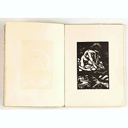
Les Strophes libertines du chevalier Naja. Bois originaux de Gécé.
First edition of this under cover published book with a collection of 20 poems celebrating "les fesses de la femme, ses lingeries et les plaisirs qu'on peut prendre ...
- $400 / ≈ €344
Date: Paris, Priape, ca. 1920

Cigarettes Saphir.
Beautiful late Art Nouveau style poster for the tobacco brand Cigarettes Saphir. Printed by Imprimerie Moullot, in Paris and designed by Stephano. The poster shows a very...
Date: Marseille, ca. 1920
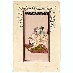
Indian painting on paper.
Fine miniature, presenting a couple in love making position, set in a landscape. The miniature has been painted in Iran or India in late 19th - early 20th century. The mi...
- $100 / ≈ €86
Date: India, ca. 1920