Browse Listings

Folies Bergere - Folies de Paris. La revue de Hélène Martin . . .
Original advertising poster for Les Folies Bergère cabaret in Paris. The Théâtre des Folies Bergère is a famous Parisian performance hall inaugurated on May 2, 1869 a...
Date: Paris, ca. 1977

Folies Bergere - Hélène Martin présente Folie je t'adore. . .
Original advertising poster for Les Folies Bergère cabaret in Paris. The Théâtre des Folies Bergère is a famous Parisian performance hall inaugurated on May 2, 1869 a...
- $380 / ≈ €331
Date: Paris, ca. 1977
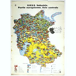
U.R.S.S. Industrie. Partie européenne, Asie centrale. (3)
Map of Eastern Russia. Propaganda poster for Russia's industry. Text in French. Editions de l'Agence de presse Novosti".More about War Maps & Propaganda maps [+]
- $100 / ≈ €87
Date: USSR, 1978

U.R.S.S. Energie Eléctrique. (5)
Map of Russia. Publicity poster for Russia's electrical production. Text in French. Editions de l'Agence de presse Novosti".More about War Maps & Propaganda maps...
Date: USSR, 1978
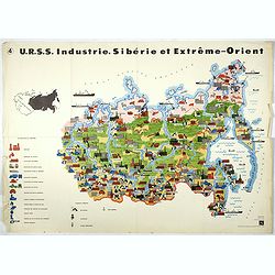
U.R.S.S. Industrie. Sibérie et Extreme-Orient. (4)
Map of Siberia. Propaganda poster for Russia's in and export of industrial goods from Siberia. Editions de l'Agence de presse Novosti".More about War Maps & Prop...
- $150 / ≈ €131
Date: USSR, 1978
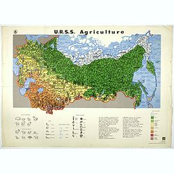
U.R.S.S. Agriculture. (6)
Map of Russia. Propaganda poster for Russia's in and export of industrial goods. With a key in bottom. Text in French. Editions de l'Agence de presse Novosti".More a...
- $100 / ≈ €87
Date: USSR, 1978
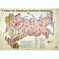
L'Union des Républiques socialistes Soviétiques. (2)
Map of Russia. Propaganda poster showing Russia' s population. With a key. Text in French. Editions de l'Agence de presse Novosti".More about War Maps & Propagan...
- $100 / ≈ €87
Date: USSR, 1978

PARADIS LATIN - Number One.
Poster for the Nuit de Paradis review, by Jean-Marie Rivière, the first Paradis Latin review in 1979.Read more about Poster History [+]
- $180 / ≈ €157
Date: Paris, 1978
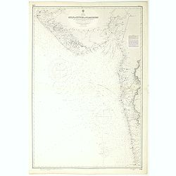
India west coast Gulf of Cutch to Vijaydurg . . .
Chart of India's west coast map surveyed by the hydrographer Captain JF Parry. A highly corrected version of Admiralty chart 2736 originally published 1st July 1915. Date...
- $200 / ≈ €174
Date: London, 1915-1980
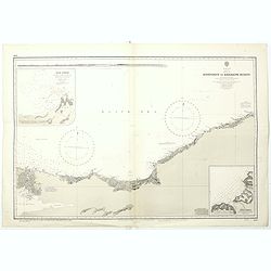
Black sea - Sheet IX - Bosporus to Kerempe Burnu . . .
A highly corrected version of Admiralty chart 2238 originally published 16th June 1854. Edition Date 1980.Detailed chart of Bosporus. With prohibited landing places in pu...
- $100 / ≈ €87
Date: London, 1854-1980

Thé Ceylan, Darjeeling, Darceyta, Chine.
Ceylon tea, Darjeeling, Darceyta, China. Advertising cardboard. Lithograph enhanced with gouache. Printed in France. King René's Illuminator.Jean Adrien Mercier, born Au...
Date: Paris, ca 1980

Bal du Moulin Rouge Paris - Femmes Femmes Femmes..
Design by René Gruau for Moulin Rouge. René Gruau (1909-2004) was a Franco-Italian artist. He enjoyed real success after World War II working as a fashion illustrator f...
Date: Paris, G. Cravenne, ca. 1980

Panache la nouvelle revue du Lido.
Very decorative poster designed by René Gruau for the Lido and its review Panache on the Champs Elysées, Paris. The bluebells are pictured for the 1985 show. René Grua...
Date: Paris, ca. 1980

Lido - Le plus célèbre cabaret du monde.
Very decorative poster designed by René Gruau for the Lido, showing a show leader lady. René Gruau (1909-2004) was a Franco-Italian artist. He enjoyed real success afte...
- $300 / ≈ €262
Date: Paris, ca. 1980

Lido de Paris - Nouveau spectacle Christian Clerico présente C'est magique.
Very decorative poster designed by René Gruau for the Lido, made on the occasion of the release of the new show "It's magic". René Gruau (1909-2004) was a Fra...
- $300 / ≈ €262
Date: Paris, ca. 1980

Venice Simplon Orient-Express. London-Paris-Venice.
Vintage poster by Pierre Fix Masseau for the restoration of the mythic "Orient-Express" in 1981.Pierre Fix-Masseau (1905-1994) is a French poster artist, son of...
Date: Paris, ca. 1981
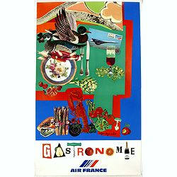
AIR France - Gastronomie
An atypical Air France poster designed by Roger Bezombes in 1980 that turns traditional Air France poster art on its head: if the goal of an advertising poster is to crea...
Date: Murlot, Paris, 1981
![[Title in Russian; translated to : Who the death bears, that's himself in the end I'm sure I'll stretch my legs. (Google translation) ]](/uploads/cache/41506-250x250.jpg)
[Title in Russian; translated to : Who the death bears, that's himself in the end I'm sure I'll stretch my legs. (Google translation) ]
Propaganda mini poster published in Russia during The Cold War (1979–1985). The time refers to the phase of a deterioration in relations between the Soviet Union and th...
Date: Russia, 1982
![[Title in Russian; translated to : Believe in the power of a nuclear trucheon - It's up to you to celebrate a wake. ]](/uploads/cache/41508-250x250.jpg)
[Title in Russian; translated to : Believe in the power of a nuclear trucheon - It's up to you to celebrate a wake. ]
Propaganda mini poster published in Russia during The Cold War (1979–1985). The time refers to the phase of a deterioration in relations between the Soviet Union and th...
Date: Russia, 1982
![[Afghanistan].](/uploads/cache/44611-250x250.jpg)
[Afghanistan].
A scarce Russian relief map (in Russian) of Afghanistan published in Moscow during the Soviet occupation of the country during the early 1980s. Complete with a separate b...
Date: Moscow, 1982
![[Too big for their bite].](/uploads/cache/45545-250x250.jpg)
[Too big for their bite].
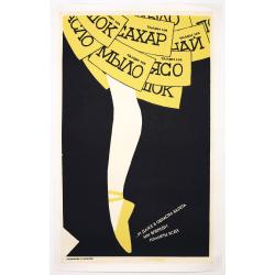
Original vintage Soviet propaganda poster - Too big for their bite - featuring a cartoon style illustration of two men with large drooling mouths and teeth trying to cons...
Date: Russia, 1982

Anamu Buru to Latakia including Iskenderun Körfezi.
A highly corrected version of Admiralty chart 2632 originally published 25 November 1955 under the Superintendence of Captain K.SB. Collins. Edition Date 1984 Detailed ch...
- $100 / ≈ €87
Date: London, 1955 - 1984
![[Improve the work of all lines of the transport Conveyor.]](/uploads/cache/47058-250x250.jpg)
[Improve the work of all lines of the transport Conveyor.]
Uncommon Soviet propaganda poster from Kommunar Publishing, located south of Moscow in Tula at 150 Friedrich Engels Street. The publishing house also issued the Kommunar ...
Date: Moscow, 1984
![[Russian poster] CCCP Homeland cosmonautics](/uploads/cache/42070-250x250.jpg)
[Russian poster] CCCP Homeland cosmonautics
Russian propaganda poster about Russian supremacy in space, designed by the artists M. Gornyak and N. Shubina. Text upper left corner translation: "The Cosmos for sc...
Date: Moscow, 1985
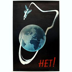
Het! (Nyet! No!).
Original vintage Soviet propaganda poster - Het! (Nyet! No!) - featuring a great illustration of a US space shuttle circling the earth and leaving a trail in the shape of...
Date: Russia, 1985
![[Stop race of nuclear weapons.]](/uploads/cache/47059-250x250.jpg)
[Stop race of nuclear weapons.]
Uncommon Soviet propaganda poster.Read more about the Soviet propaganda poster. [+]
Date: Moscow, 1986
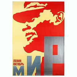
Lenin October.
Uncommon Soviet propaganda poster.Read more about the Soviet propaganda poster. [+]
Date: Moscow, 1987
![[Russian Agitprop propaganda poster for 9 May]](/uploads/cache/42073-250x250.jpg)
[Russian Agitprop propaganda poster for 9 May]
Soviet propaganda poster celebrating Victory Day (Thursday 9 May). Showing a star with USA, English, French flags partly overlapped with Soviet flag and inscription in Ru...
Date: Moskow, 1988
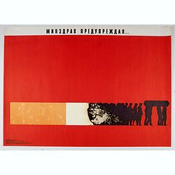
Ministry of health warned . . .
Uncommon Soviet propaganda poster against tobacco consumption.Read more about the Soviet propaganda poster. [+]
Date: Moscow, 1988

Protect the globe!, 1989.
USSR propaganda poster, with the slogan "protect de globe". A child holding a globe with flowers and birds.
Date: Russia, 1989

Save (the) world for us.
Uncommon Soviet propaganda poster. Text translates to : Save (the) world for us.Read more about the Soviet propaganda poster. [+]
Date: Moscow, 1989
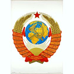
Proletarians of all countries, connect.
Uncommon Soviet propaganda poster.Read more about the Soviet propaganda poster. [+]
Date: Moscow, 1989
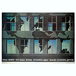
Our land is our life...
Uncommon Soviet propaganda poster. "Our land is our life. Lost one means lose other."Read more about the Soviet propaganda poster. [+]
Date: Moscow, 1989
![[A collection of 100 Soviet propaganda poster published in the 1980's]](/uploads/cache/47076-250x250.jpg)
[A collection of 100 Soviet propaganda poster published in the 1980's]
A collection of 100 Soviet propaganda posters published during the early years of the Perestroika & Glasnost period. Most posters are made by Plakat (All-Union Poster...
Date: Moscow, ca. 1980-1989

Boris Eltsine.
Artist poster about Boris Eltsine, by Mirjam Dijkema (1984) who studied Illustration and Graphic Design and Art History. Currently Mirjam is teaching design and art theor...
- $100 / ≈ €87
Date: Groningen, ca. 1990
Russian Perestroika Ballet Poster.
Wonderful and delicate Russian Perestroika poster depicting a ballerina. On the frills of her skirt, there are several messages written down, which mean « a coupon for s...
Date: Russia, 1990
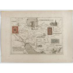
Persische Teppichknüpfgebiete und Stämme.
Map of Iran and neighboring countries in German language, published in limited edition probably in France : "Gravée à l'eau-forte et au burin. Edition limitée&quo...
Date: France ?, after 1935 - before 1991
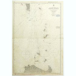
China Sea Luzon Strait between Luzon and Tai-Wan from the United States & Japanese Government chartsto 1929. . . (3804)
A highly corrected version of Admiralty chart 3804 originally published 18 September 1925 under the Superintendence of Captain P.H. Douglas. New Editions 18th December 19...
- $150 / ≈ €131
Date: London, 1929 / 1992
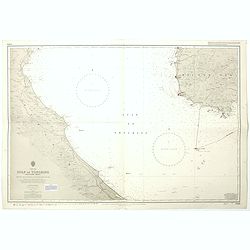
China sea Gulf of Tongking (Southern sheet).
A highly corrected version of Admiralty chart 3989 originally published 11 Mai 1962 under the Superintendence of Captain EG Irving. Detailed chart including the coasts of...
- $80 / ≈ €70
Date: London, 1962 - 1992
West Indies Virgin islands Sheet III Tortola I. to Culebra including St. Thomas...
An British Admiralty chart of the Virgin Islands. A highly corrected version of Admiralty chart 2452 originally published 15th December 1856 under the Superintendence of ...
- $135 / ≈ €118
Date: London, 1856- 1988-1993
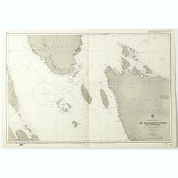
China Sea Philippine Islands - San Bernandino Strait and approaches. (3370)
A highly corrected version of Admiralty chart 3370 originally published 14th November 1924 under the Superintendence of Captain H.P. Douglas. Edition Date 1982 with furth...
- $150 / ≈ €131
Date: London, 1924 / 1996

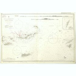
Philippine Islands - Semirara, Ilin and Ambulong 1.s with part of Mindoro. (971)
A highly corrected version of Admiralty chart 971 originally published 15th February 1866 under the Superintendence of Captain G.H. Richards. Edition Date 1991 with furth...
- $150 / ≈ €131
Date: London, 1866 / 1999
West Indies Anguilla to Puerto Rico showing the approaches to the Virgin Islands . . .
A highly corrected version of Admiralty chart 130 originally published 22nd June 1868 under the Superintendence of Captain G.H. Richards. Edition Date 1974 with further c...
- $100 / ≈ €87
Date: London, 1868 - 1999

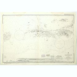
Philippine Islands - Mindanao West Coast - Basilan Strait to Camiguin Island including Tubbataha Reefs. . . (3811)
A highly corrected version of this oversized Admiralty chart 3811 originally published 26th February 1925 under the Superintendence of Captain P.H. Douglas. Edition Date ...
- $150 / ≈ €131
Date: London, 1925 / 2005

July tenth: The Flaming Tsunamis fatter than Albert a billion ernies stuck lucky and the best of the worst.
Poster by Justin Santora, numbered 8/65 ans signed in pencil, in the lower right margin.Santora began working as a freelance illustrator and screen printer like some of C...
Date: Chicago, ca. 2008
![Grote Atlas van de Verenigde Oost-Indische [Complete set of 7 volumes] Compagnie/Comprehensive Atlas of the Dutch United East India Company](/uploads/cache/49206-250x250.jpg)
Grote Atlas van de Verenigde Oost-Indische [Complete set of 7 volumes] Compagnie/Comprehensive Atlas of the Dutch United East India Company
This seven volume atlas was published in a limited edition. It covers all territories and possessions under the Charter of the Dutch East India Company (VOC) from 1602-17...
Date: Voorburg, Asia Maior/Atlas Maior, 2006-2010
![[Lot of 3] Celestial chart depicting astronomical division of the earth.](/uploads/cache/IMG_2256-250x250.jpg)
[Lot of 3] Celestial chart depicting astronomical division of the earth.
A chart depicting the astronomical division of the earth. With on both sides a descriptionary text. All within an elaborate and very decorative border. A very fine item. ...
- $250 / ≈ €218
Date: Paris, L.C. Desnos,1761.

Comedies de Moliere . . .Le Malade Imaginaire.
A lovely colored lithograph of "The Imaginary Disease" or "The Hypochondriac", by Edouard Lievre, published in Paris mid way through the nineteenth ce...
Date: Paris, ca 1860?

Carte géologique détaillée. Beyrouth.
Geological or soil map showing part of Lebanon with Beyrouth, including in top a colored legend with signs of the different geological ages. Provenance : Fondation P. Fal...
Date: Liban, Service geographique des F.F.L., 1945.

Carte géologique détaillée. Jezzîne.
Geological or soil map showing part of Lebanon with Jezzîne, including a legend with signs of the different geological ages and giving many information of greatest inter...
Date: Liban, Service geographique des F.F.L., 1945.

Carte géologique détaillée. Râchaïya Nord.
Geological or soil map showing part of Lebanon with Râchaïya , including a legend with signs of the different geological ages and giving many informations of greatest i...
Date: Liban, Service geographique des F.F.L., 1945.

Carte géologique détaillée. Zahle.
Geological map showing part of Lebanon with Zahle. , including a legend with signs of the different geological ages. Provenance : Fondation P. Fallot
Date: Liban, Service geographique des F.F.L., 1945.

Carte geologique detaillee. Jbail.
Geological or soil map showing part of Lebanon with Jbail antique Byblos Ancien Port phenicien / scale 1 : 50 000., including a legend with signs of the different geologi...
Date: Liban, Service geographique des F.F.L., 1945.
![[Set of two maps of the Pacific Ocean with transportation lines, with Ottoman script]](/uploads/cache/44327-250x250.jpg)
[Set of two maps of the Pacific Ocean with transportation lines, with Ottoman script]
Two post card size maps showing the Pacific Ocean with transportation lines. The maps are in Ottoman script prepared by Mehmet EŞREF in a small atlas : عمومولاي...
Date: Istanbul, Şirket-i Mürettibiye ve Karacoğlu Matbaas&#