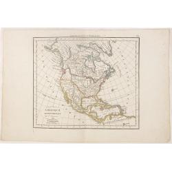
Browse Listings in America > North America
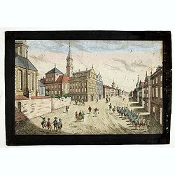
![Prospect des Plazes vor dem Rath Haus zu Boston. Vuë de la Rue et de la Maison de Ville a Boston. [together with] Prospect der König[lichen] ...](/uploads/cache/34214-250x250.jpg)
Prospect des Plazes vor dem Rath Haus zu Boston. Vuë de la Rue et de la Maison de Ville a Boston. [together with] Prospect der König[lichen] ...
Two so-called optical prints show a decorative imaginary view of the old state house, built in 1657, which was the center of government for the colony of Massachusetts an...
- $1500 / ≈ €1318
Date: Augsburg, ca. 1776

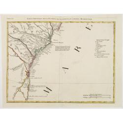
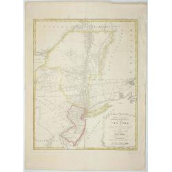
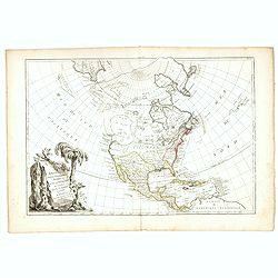
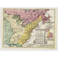
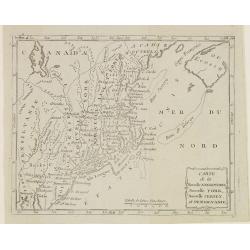
A Map of the most Inhabited part of New England containing the Provinces of Massachusetts Bay and New Hampshire, with the Colonies of Connecticut and Rhode Island.
A copper engraving in four sheets, published in Georges Louis Le Rouge, in his "Atlas Ameriqua in Septentrional Contenant les details des differentes provinces, de c...
Date: Paris, 1777

Carte nouvelle de l'Amérique angloise contenant tout ce que les Anglois possèdent. . . avec la Floride / gravée. . . par Maththias Albert Lotter. . .
As mentioned in the title piece, the map includes the area at that time in the possession of the English, i.e. Canada, New Large, beautiful and detailed map of the Easter...
Date: Augsburg, 1777
![Carte nouvelle de l'Amérique angloise contenant tout ce que les Anglois possèdent […] avec la Floride / gravée[…] par Maththias Albert Lotter. . .](/uploads/cache/47847-250x250.jpg)
Carte nouvelle de l'Amérique angloise contenant tout ce que les Anglois possèdent […] avec la Floride / gravée[…] par Maththias Albert Lotter. . .
A large, beautiful and detailed map of the Eastern Seaboard, from Northern Florida St. Augustine) to Newfoundland, and the St. Lawrence Gulf, including numerous Indian tr...
Date: Augsburg, 1777
![[Lower half] Amerique Septentrionale avec les Routes, Distances en miles, Limites et Etablissements François et Anglois Par le Docteur Mitchel Traduit de 'Anglois..](/uploads/cache/49378-250x250.jpg)
[Lower half] Amerique Septentrionale avec les Routes, Distances en miles, Limites et Etablissements François et Anglois Par le Docteur Mitchel Traduit de 'Anglois..
This is the important 1777 French edition by Georges Le Rouge of the seminal John Mitchell map of eastern North America. The Mitchell map is considered the single most im...
Date: Paris, 1777

Ilse Paese de' Selvaggi.. Lago Superiore. (Florida and the Bahamas)
Antonio Zatta published an Italian version of the John Mitchell map in twelve sheet. This sheet depicts Lake Superior in the Bellin version, as it appeared on the Mitchel...
Date: Venice, 1778
Parte Orientale della Florida, della Giorgia, e Carolina. . .
Attractive map covering the coast from S.Augustine till Long Bay, including Jacksonville, Savannah. From Zatta's Atlante Novissimo.
Date: Venice, 1778

Carte Réduite Des Côtes Orientales De L' Amérique Septentrionale Contenant Partie du Nouveau Jersey.. Virginie.. Georgie..
Uncommon chart that extends from Delaware Bay and Philadelphia south through much of Georgia to Island Amelia and St. Johns River. Fleur-de-lis and rhumb lines fill the s...
Date: Paris, 1778
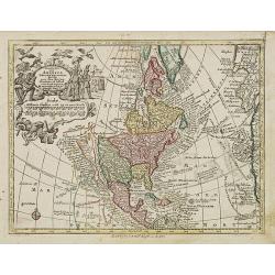
Nov' Orbis Sive America Septentrionalis. . .
Miniature map of North America, a reduction of the appropriate part of Seutter's folio map of the Americas, drawn by Albert Seutter. An unusual looking map, its projectio...
Date: Augsburg, J.M.Will, 1778
Carte des troubles De L'Amerique Levée par Ordre du Chevalier Tryon. . . New-York.. Jersey..
Revolutionary War mapA French edition of this uncommon Revolutionary War map describes the region from Salem, Massachusetts, to Buzzard's Bay, south to the Delaware River...
Date: Paris, 1778
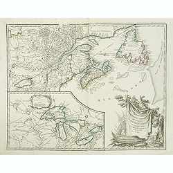
Partie de l'Amerique septent? Qui comprend la nouvelle France. . .
A fine copy of this map of New Foundland, Nova Scotia and the course of the St.Lawrence to Lake Ontario in a forth state.An inset shows Bellini's famous and important map...
Date: Paris, 1755-1778

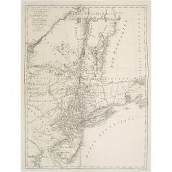
Mappa Geographica provinciae Nova Ebboraci ab Anglis NEW-YORK dictae. . .
During the Revolution, this map afforded British commanders an excellent overview of areas that would be crucial in the early years of the war, particularly the Hudson Va...
Date: Nuremberg, 1778

Vue de la Rue du Roi, vers la Porte de la Campagne a Boston.
A vue d'optique of the city of Boston. A view of a typical Bostonian street, with buildings opening directly onto the throughway, groups of people, gentlemen, workers and...
Date: Augsburg, 1778
Mappa Geographica provinciae Nova.. NEW-YORK..
This map afforded British commanders during the Revolution an excellent overview of areas that would be crucial in the early years of the war, in particular the Hudson Va...
- $1500 / ≈ €1318
Date: Nuremburg, 1778

Mappa geographica Provinciæ Nova Eboraci ab Anglis New-York . . .
Lower part of the two sheets map of Homann Heirs' edition of Sauthier's celebrated map of New York and New Jersey, made during the Revolutionary War. Appears in Homann's ...
Date: Nuremburg, 1778
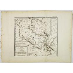
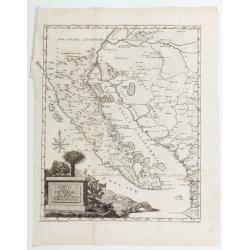
Carte de la Californie et des Pays Nord-Ouest. . . 4de Carte.
Diderot's famous 2 on 1 map shows the two early mappings of the west coast of North America, the first after Visscher, the second after Plancius' World map. Both show the...
Date: Paris, 1779

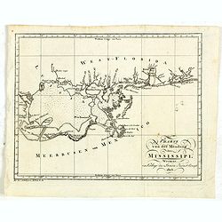
Carte d'une Partie des Cotes de la Floride et de la Louisiane, Contenant le Cours du Mississipi...
A well engraved and highly detailed chart of part of the Gulf Coast, dated 1778 that was issued in Neptune americo-septentrionale. The chart covers the area between St. J...
Date: Paris, 1778-1780
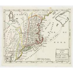
Carte de la Nouvelle Angleterre, Nouvelle York, Nouvelle Jersey, et Pensilvanie.
Highly detailed regional map of the Northeastern US, featuring numerous place names, Forts, Native American tribes, rivers,coastal banks, and other details. This is a Fre...
Date: Paris, 1780
Prospect der Strasse gegen der Kirche der Recolecten in der obern Stadt zu Quebec. Vuë de la Rue des Recolets dans la haute Ville de Quebec.
A so-called optical print showing a decorative imaginary town view of Québec, with a street view with soldiers marching and pedestrians, an idealized view depicting Québe...
Date: Augsburg, ca. 1780

Connecticut and Parts adjacent at Amsterdam. .
A nice example of this early map of the state of Connecticut, with part of Rhode Island to the east, Long Island to the south, and New York to the east. Rivers, roads, to...
Date: Amsterdam, 1780
L'Amerique Septentrionale Divisee en Ses Principaux Etats. . .
Engraved by Lattré. This map is most notable for its depiction of Mer de L'Quest or Sea of the West, near modern-day Seattle. A great sea, easily the size of the Mediterr...
- $400 / ≈ €352
Date: Paris, 1782

Carte du Mexique et des Etats Unis d'Amérique...
A later edition of De l'Isle's foundation map of 1703, is widely regarded as one of the most influential maps in the history of American Cartography. This updated version...
Date: Paris, 1783
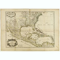
Carte du Mexique et des Etats Unis d'Amérique...
A later edition of De l'Isle's foundation map of 1703 is widely regarded as one of the most influential maps in the history of American Cartography. This updated version ...
Date: Paris, 1783
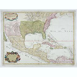
Carte du Mexique et des Etats Unis d'Amérique…
A later edition of De l'Isle's foundation map of 1703, widely regarded as one of the most influential maps in the history of American Cartography. This updated version o...
Date: Paris, 1783

Carte Générale du Canada, de la Louisiane, de la Floride, de la Caroline..
Map of the eastern part of the United States and Canada. With inset map of Hudson and Baffin bays. in the lower right corner.Venetian edition of d'Anville's map, from &qu...
Date: Venice, 1776 - 1784
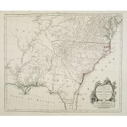
Partie Méridionale de la Louisiane, avec la Floride, la Caroline et la Virginie..
Fine map of southeastern part of the United States after d'Anville's, to whom Santini gives credit in the cartouche.It covers the Atlantic coastline between the Chesapeak...
Date: Venice, 1776 - 1784

ETATS-UNIS DE L'AMÉRIQUE SEPTENTRIONALE Avec LES ISLES ROYALE, DE TERRE NEUVE, DE S.T JEAN, L'ACADIE, &c. 1785. Supplement a l'Atlas de M. Robert de Vaugondy a Paris Ches Boudet Ingenieur du Roi.
A map of the eastern United States with "Supplément à l'atlas de M. Robert de Vaugondy à Paris chez Boudet Imprimeur du Roi", in place of the attribution to Del...
Date: Paris, 1785
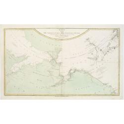
Karte von den N.W. Amerikanischen und N.OE. Asiatischen Kusten nach den Untersuchungen des Kapit. Cook...
A detailed large-scale map showing the Bering Strait, Kamchatka, Alaska and much of North America. While the Russian coastline is shown with reasonable accuracy. Showin...
Date: Vienna, 1788
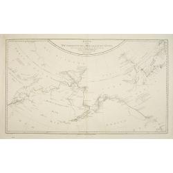
Karte von den N.W. Amerikanische und N.O.E. Asia. . .
German edition of Cook's explorations along the NW Coast of America and NE Coast of Asia, based upon the original work by Lieutenant Henry Roberts.A detailed large-scale ...
- $400 / ≈ €352
Date: Vienna, 1788
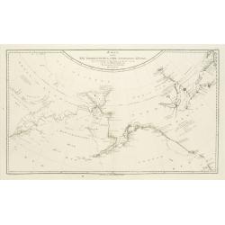
Karte von den N.W.Amerikanische und N.O.E. Asia..
A detailed large-scale map showing the Bering strait, Kamchatka, Alaska, and much of North America. While the Russian coastline is shown with reasonable accuracy. Showing...
Date: Vienna 1788

Map of Louisiana from D'Anville's Atlas.
This map presents a highly detailed treatment of the region from Cabo Del Norte to the Apalachiola River, centered on the mouth of the Mississippi and extending inland to...
Date: London, 1788
Carta Della California Suo Golfo E. Contracoste della Nueva Spagna.
Map featuring the California Peninsula and New Spain by Francisco Saverio Clavigero, engraved by J. Zambelly. Title cartouche within a landscape of cacti and palm trees.O...
Date: Venice, 1788
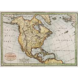
![[North America]](/uploads/cache/25907-250x250.jpg)
[North America]
Uncommon map of North America. The young United States incorporates the upper Midwest, with the remaining western territories of Louisiana, Nouveau Mexique, Nouveau Albio...
Date: Augsburg, ca. 1790
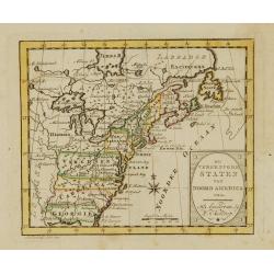
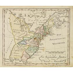
Die Vereinigten Staaten von Nord Amerika..
Uncommon map of the east coast of North America, including the Great Lakes area. To the right inset map of New Foundland. After the map by William Faden of 1783. With col...
Date: Germany, 1790
De vereenigde staten van Noord America.
Rare miniature map of Eastern United States. The map carries the signatures of W.Holtrop and the engraver H.Klokhoff. Steven van Esveldt's business was carried on by his ...
Date: Amsterdam, 1791

Bison Iubatus.
Etching of a bison by Leendert Brasser (1727 - 1793) after a painting of the Dutch artist Gerrit van den Heuvel.An early portrait of a bison, etched by Leendert Brasser (...
Date: Rotterdam, 1766-1793

New Jersey entworfen von D.F. Sotzmann. Hamburg bey Carl Ernst Bohn 1796 . . . NO.VIII
Extremely rare map of New Hampshire prepared by Daniel Friedrich Sotzmann for Christopher Ebeling's "Erdbeschreibung von Amerika", a project ended after only te...
Date: Hamburg, Carl Ernst Bohn, 1797

Rhode Island entworfen von D.F. Sotzmann. Hamburg bey Carl Ernst Bohn 1798 . . . NO.V
Extremely rare map of Rhode Island prepared by Daniel Friedrich Sotzmann for Christopher Ebeling's "Erdbeschreibung von Amerika", a project ended after only ten...
Date: Hamburg, Carl Ernst Bohn, 1797
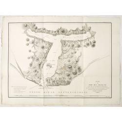
Plan du Port des Francais sur la Cote du Nord-Ouest de l'Amerique, par 58°37' de Latitude Nord et 139°50' de Longitude Occidentale, Decouverte le 2 Juillet 1786, par les Fregates Francaise la Boussole et l'Astrolabe.
Chart of the entrance of Bassin de L'Quest , visited on July 2nd 1786 by La Perouse. On many 18th century maps we find a depiction of Mer de L'Quest or Sea of the West a ...
- $500 / ≈ €439
Date: Paris, 1798

New Yok entworfen von D.F. Sotzmann. Hamburg bey Carl Ernst Bohn 1799 . . . NO.VII
An extremely rare map of New York prepared by Daniel Friedrich Sotzmann for Christopher Ebeling's "Erdbeschreibung von Amerika", a project ended after only ten ...
Date: Hamburg, Carl Ernst Bohn, 1799
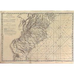
Carte Réduite des Côtes Orientales Del'Amérique Septentrionale Contenant partie du Nouveau Jersey, la Pen-sylvanie, le Mary-land, la Virginie, la Caroline Septentrionale, la Caroline Méridionale et la Georgie. . .
Scarce Rome edition of an French map made expressly for use of the French Navy during the American Revolution. Covering the area of Maryland, North and South Virginia. Ph...
- $900 / ≈ €791
Date: Genova, Yves Gravier, c.1800

Carte de la partie septentrionale des Etats Unis..
An attractive 1801 map of North America's east coast north of Long Island. Including St.Laurence River as far south as Lake Ontario. Engraved by André and P.F.Tardieu. A ...
Date: Paris, 1801

United States of North America. Carte des Etats-Unis de l'Amerique Septentrionale / copiée et gravée sur celle d'Arrowsmith, corrigée et considérablement augmentée... par P. F. Tardieu...
FIRST EDITION. An impressive wall map here in 4 unjoined sheets and large margins. RARE in these untouched, full sheets. Recorded examples are usually offered as folding ...
Date: Paris: An XI - 1802
![[Lot of 5 maps] Kaart van de noord-west kust van Amerika en de noord-oost kust van Asia.](/uploads/cache/19136-250x250.jpg)
[Lot of 5 maps] Kaart van de noord-west kust van Amerika en de noord-oost kust van Asia.
- Kaart van de noord-west kust van Amerika en de noord-oost kust van Asia. Opgenoomen in de Jaaren 1778 en 1779. Captain James Cook (1728-79), explorer, circumnavigato...
Date: Leiden, 1795-1803

Carte des côtes du Golfe du Mexique compris entre la pointe sud de la presqu'Ile de la Floride et la pointe nord de la presqu'Ile d'Yucatan:...
Detailed and important early chart of the Gulf Coast and Florida and dated 1800. First French edition of "the first printed [map] to show and name Galveston Bay&qu...
Date: Paris, 1800/1803
Charte von der mündung des Mississippi. Weimar, Verlage des Landes Indust. Compt. 1803.
Scarce map showing the mouth of the Mississippi into the Gulf of Mexico. With Pensacola in Western Florida, Mobile Bay in Alabama and Louisiana with New Orleans and their...
Date: Weimar, 1803
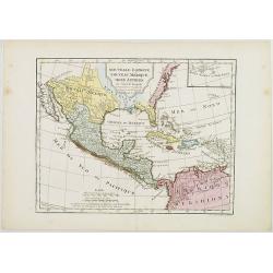
Nouvelle Espagne, Nouveau Méxique, Isles Antilles, par Robert de Vaugondy corrigés par le Cen. Lamarche Géog. Successeur de Vaugondy. l''An 3e.
Although dated 1794/95 [l'An 3e.], the map is a copy of an earlier map which appeared in Robert de Vaugondy's 1778 atlas. Hence, it does not show the newly independent Un...
Date: Paris, 1794 - 1806
Carte de la Nouvelle Angleterre, Nouvelle York, Nouvelle Jersey, et Pensilvanie.
Map of the north eastern part of the United States, from Atlas de la Géographie de toutes les parties du monde .. Ouvrage destiné pour l'education, et nécessaire aux négo...
Date: Paris, Prudhomme, Levrault, Debray, 1806
Die Vereinigten Staaten von Nord-Amerika.
Nice little German map of the early United States. The only state shown west of the Appalachian Mountains is Kentucky. Above which is a strangely shaped unnamed region (O...
Date: Augsburg, 1812
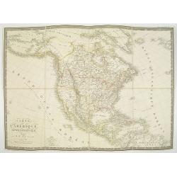
Carte d' Amérique Septentrionale 1817.
Map of North and Central America. Engraved by E.Collin, active at 23, quai des Augustins, Paris.
Date: Paris, 1817
Little Egg Harbour.
A small sea chart showing Little Egg Harbour east of Tucker's Island. This map was published in the “American Coast Pilot”, a detailed guide to harbors, capes and headlan...
- $50 / ≈ €44
Date: New York, 1817
![Etats-Unis de L'Amerique Septentrionale. [Two sheets in manuscript ]](/uploads/cache/03972-250x250.jpg)
Etats-Unis de L'Amerique Septentrionale. [Two sheets in manuscript ]
Two sheets giving detailed information in French about the population in 1810, principal cities, products of industry and commerce, the financial situation for 1818, etc....
Date: France, ca. 1819
Gedeelte van den Vereenigden Staat van Noord Amerika.
A rare an detailed map of the eastern part of the United States of America. After Isaac Weld's map from his Travels through the States of North America 1799. Barbara Back...
Date: Netherlands c. 1820
L'America septentrionale.
Charming and finely engraved map of North America from the rare atlas Atlante Tascabile o sia Serie di Num. XXI Cartine Geografiche nelle quali si rappresenta in ristrett...
Date: Rome, 1823

Map of Pensylvania and New Jersey by H.S. Tanner.
First edition of this rare and important map of Pennsylvania and New Jersey by H.S. Tanner and published in his "New American Atlas" from 1823. Includes roads, ...
Date: Philadelphia, Henry Tanner, 1823
Amérique septentrionale.
A fine map of North America published by the well-known Paris publisher of maps, globes and atlases C.F. Delamarche.
- $110 / ≈ €97
Date: Paris, 1824
![Carte Géographique [ . . .] de la Pensylvanie.](/uploads/cache/14221-250x250.jpg)
Carte Géographique [ . . .] de la Pensylvanie.
Detailed map of Pennsylvania. From J.A. Buchon, Atlas Gégraphique Statistique, historique et chronologique des deux Amériques et des isles adjacentes. traduit de l'atlas ...
Date: Paris, 1825
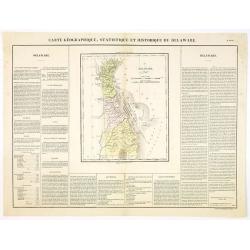
Carte Géographique .. Delaware.
Detailed map of Delaware. From J.A. Buchon, Atlas Gégraphique Statistique, historique et chronologique des deux Ameriques et des isles adjacentes, traduit de l'atlas exéc...
Date: Paris, 1825
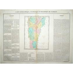
Carte Géographique .. Vermont.
Detailed map of Vermont. From J.A. Buchon, Atlas Gégraphique Statistique, historique et chronologique des deux Amériques et des isles adjacentes: traduit de l'atlas exécu...
Date: Paris, 1825
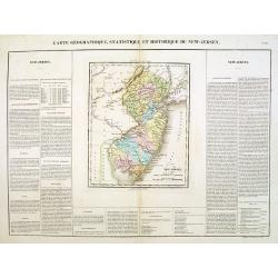
Carte Géographique .. New Jersey.
Detailed map of New Jersey. From J.A. Buchon, Atlas Gégraphique Statistique, historique et chronologique des deux Amériques et des isles adjacentes: traduit de l'atlas ex...
Date: Paris, 1825
Carte de l'Amerique septentrionale Rédigée par A.H.Brué géographe.
Detailed dissected folding-map of North and Central America by Brué, originally published in Atlas Universel but here mounted on linen and intersected in 8 parts. Next to...
- $250 / ≈ €220
Date: Paris, 1825

The Traveller's Guide. A Map Of The Roads, Canals And Steam Boat Routes Of The United States ... Designed for the use of Travellers, By H.S. Tanner.
Rare first edition of Tanner's travel map in pocket map form, in it original red leather covers, with the map and no text, as issued. Ristow says the first edition was 18...
Date: Philadelphia, 1825
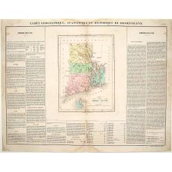
Carte Géographique, statistique et historique du Rhode Island.
Detailed map of Rhode Island. From J.A. Buchon, Atlas Gégraphique Statistique, historique et chronologique des deux Amériques et des isles adjacentes, traduit de l'atlas ...
Date: Paris, 1825
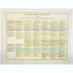
Carte Chronologiquedes Etats-Unis.
A hand colored historical timeline table (in French), highlighting "the main [historical] events in the years from their establishment to the declaration of independ...
- $100 / ≈ €88
Date: Paris, 1825
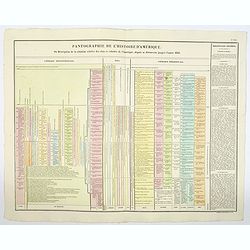
Pantographie de l'Histoire d'Amerique, ou Description de la situation relative des etats et colonies de l'Amerique. . .
An attractivelooking hand colored historical timeline table (in French), charting important historical events and discoveries of America and their States and Colonies sin...
- $100 / ≈ €88
Date: Paris, 1825
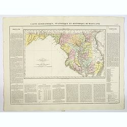
Carte Geographique, Statistique ey Historique du Maryland.
A lovely, detailed map of Maryland, from Buchon's, Atlas Gégraphique Statistique, historique et chronologique des deux Ameriques et des isles adjacentes, traduit de l'atl...
- $100 / ≈ €88
Date: Paris, 1825
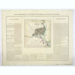
Carte Geographique, Statistique ey Historique du District de Colombie.
A lovely, detailed map of the District of Columbia, (Washington) from Buchon's, Atlas Gégraphique Statistique, historique et chronologique des deux Ameriques et des isles...
- $100 / ≈ €88
Date: Paris, 1825
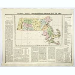
Carte Geographique, Statistique et Historique de Massachusetts.
A detailed map of Massachusetts, from Buchon's Atlas Gégraphique Statistique, historique et chronologique des deux Ameriques et des isles adjacentes, traduit de l'atlas e...
- $100 / ≈ €88
Date: Paris, 1825
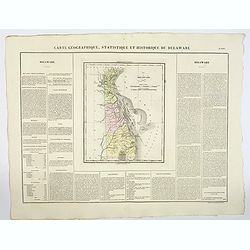
Carte Geographique, Statistique et Historique du Delaware.
A nice detailed map of Delaware, from Buchon's Atlas Gégraphique Statistique, historique et chronologique des deux Ameriques et des isles adjacentes, traduit de l'atlas e...
- $100 / ≈ €88
Date: Paris, 1825
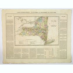
Carte Geographique, Statistique et Historique du New York.
A detailed map of State of New York, from Buchon's Atlas Gégraphique Statistique, historique et chronologique des deux Ameriques et des isles adjacentes, traduit de l'atl...
- $100 / ≈ €88
Date: Paris, 1825
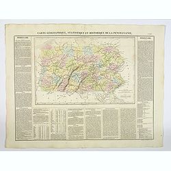
Carte Géographique, Statistique et Historique de la Pensylvanie.
A detailed map of Pennsylvania, from Buchon's Atlas Gégraphique Statistique, historique et chronologique des deux Amériques et des isles adjacentes, traduit de l'atlas ex...
- $100 / ≈ €88
Date: Paris, 1825
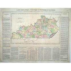
Carte Géographique .. Kentucky.
Detailed map of Kentucky. From J.A. Buchon, "Atlas Gégraphique Statistique, historique et chronologique des deux Ameriques et des isles adjacentes; traduit de l'atla...
Date: Paris, 1825

Missions et Résidences dans la Partie Septentrionale de l'Amérique Contenant 50 Jésuites.
Very rare missionary map of North America from "Atlas Universel indiquant les établissemens des Jésuites: avec la manière dont ils divisent la terre, suivi desévénem...
Date: Paris, Ambroise Dupont , 1826

Danse d'indiens.
From Giulio Ferrario's work Le Costume ancien et moderne ou histoire du gouvernement, de la milice, de la religion, des arts, etc. published in Milan by the author betwee...
Date: Milan, 1827
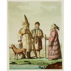
Les Aleuts.
From Giulio Ferrario's work Le Costume ancien et moderne ou histoire du gouvernement, de la milice, de la religion, des arts, etc. published in Milan by the author betwee...
Date: Milan, 1827
![[ Niagara Falls ]](/uploads/cache/27543-250x250.jpg)
[ Niagara Falls ]
Two aquatints depicting the Horse Shoe Fall (also known as Canadian Falls at the top) and the Fort Schloper Fall (bottom) engraved by Biasolé. From Giulio Ferrario's work...
Date: Milan, 1827
![[ View of an inn and a horse carriage. ].](/uploads/cache/27552-250x250.jpg)
[ View of an inn and a horse carriage. ].
Aquatint depicting a view of an inn and a horse carriage engraved by Fumagalli. Plate N°44.From Giulio Ferrario's work Le Costume Ancien et Moderne ou Histoire du gouvern...
Date: Milan, 1827
![[ William Penn's treaty with the Indians in 1681 ].](/uploads/cache/27555-250x250.jpg)
[ William Penn's treaty with the Indians in 1681 ].
Aquatint depicting William Penn's treaty with the Indians in 1681, after a painting by Benjamin West.William Penn (October 14, 1644 - July 30, 1718) was founder and "...
Date: Milan, 1827
![[ A typical Timucua Indians Village ].](/uploads/cache/27559-250x250.jpg)
[ A typical Timucua Indians Village ].
Aquatint depicting a typical Timucua Indians Village engraved by Fumagalli, after Jacques LeMoyne. The Timucua of northeast Florida (the Saturiwa and Agua Dulce tribes) a...
Date: Milan, 1827
![[View of the Potomac River from Mount Vernon ].](/uploads/cache/27550-250x250.jpg)
[View of the Potomac River from Mount Vernon ].
Aquatint depicting a view of the Potomac River from Mount Vernon engraved by Fumagalli. Plate N°46.From Giulio Ferrario's work Le Costume Ancien et Moderne ou Histoire du...
Date: Milan, 1827
