Browse Listings in America > North America > North Pole

44 listings found. Showing results 1 to 44
Polus Arcticus cum vicinis regionibus.

Map of the North Pole regions from the 1608 second edition of Jodocus Hondius' Atlas Minor.A reduction of the 1606 Mercator-Hondius folio map (which is a later state of t...

$500 / ≈ €438
Maker / Publisher: MERCATOR, G. / HONDIUS, J.
Place & Date: Amsterdam, 1608


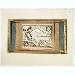
Poli Arctici, et circumiacentium terrarum descriptio novissima. . .

A re-issue of the Hondius' plate. A particularly decorative map of the North Pole with Iceland. Several Dutch names in Labrador. The toponymy in Canada reflects the conti...

$2200 / ≈ €1927
Maker / Publisher: HONDIUS, H. / DE WIT, F.
Place & Date: Amsterdam, 1660


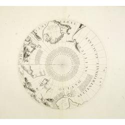
Two polar calottes from a globe.

Two polar calottes from 110 centimeters in diameter globe of 1688 including the northern part of Baffin Bay, Greenland, Iceland, Nova Zembla. Coronelli elected to follow ...

$2000 / ≈ €1752
Maker / Publisher: CORONELLI, V. M.
Place & Date: Venice, 1696


La Terre du Nord.

Map of the Arctic Circle, set within a series of decorative borders, printed from a different copper plate. All counties that lie within or near the North Pole are shown ...

$900 / ≈ €788
Maker / Publisher: VAN DER AA, P.
Place & Date: Amsterdam, 1713


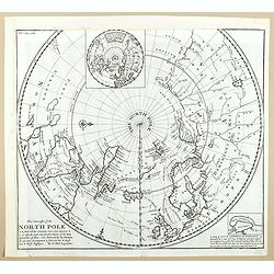
This Draught of the North Pole is to show all the Countries near and adjacent to it . . .

The polar map shows the latest discoveries and routes of numerous explorers during their attempts to find a Northwest and Northeast Passage, including James, Hudson, and ...

$300 / ≈ €263
Maker / Publisher: MOLL, H.
Place & Date: London, ca. 1728
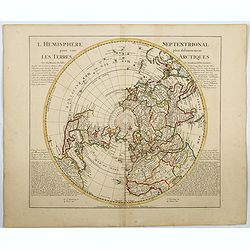


Carte nouvelle de l'Amérique angloise contenant tout ce que les Anglois possèdent. . . avec la Floride / gravée. . . par Maththias Albert Lotter. . .

As mentioned in the title piece, the map includes the area at that time in the possession of the English, i.e. Canada, New Large, beautiful and detailed map of the Easter...

$1500 / ≈ €1314
Maker / Publisher: LOTTER, M.A.
Place & Date: Augsburg, 1777


L'Amerique Septentrionale Divisee en Ses Principaux Etats. . .

Engraved by Lattré. This map is most notable for its depiction of Mer de L'Quest or Sea of the West, near modern-day Seattle. A great sea, easily the size of the Mediter...

$400 / ≈ €350
Maker / Publisher: JANVIER,Sr. / LATTRE
Place & Date: Paris, 1782


Carte du Mexique et des Etats Unis d'Amérique...

A later edition of De l'Isle's foundation map of 1703, widely regarded as one of the most influential maps in the history of American Cartography. This updated version of...

$1500 / ≈ €1314
Maker / Publisher: L'ISLE, G. de. / DEZAUCHE.
Place & Date: Paris, 1783


ETATS-UNIS DE L'AMÉRIQUE SEPTENTRIONALE Avec LES ISLES ROYALE, DE TERRE NEUVE, DE S.T JEAN, L'ACADIE, &c. 1785. Supplement a l'Atlas de M. Robert de Vaugondy a Paris Ches Boudet Ingenieur du Roi.

A map of the eastern United States with "Supplément à l'atlas de M Robert de Vaugondy à Paris chez Boudet Imprimeur du Roi", in place of the attribution to D...

$1750 / ≈ €1533
Maker / Publisher: BOUDET. / DE VAUGONDY, R.
Place & Date: Paris, 1785


Amérique Septentrionale .. Les Etats Unis..

Very rare state: probably separately issued. Published the same year the Treaty of Paris was signed, this is one of the first maps to provide printed boundary lines for t...

$3000 / ≈ €2628
Maker / Publisher: VAUGONDY, R. de
Place & Date: Paris, 1786


AMERIQUE SEPTENTRIONALE dressée sur les Relations les plus modernes des Voyageurs et Navigateurs ou se remarquent LES ETATS UNIS. . .

This large map of North America and the West Indies was originally published in 1750: however after the Treaty of Paris recognized the United States in 1783 the map was '...

Maker / Publisher: VAUGONDY, R. de
Place & Date: Paris, after 1786
Selling price: $750
Sold in 2011


[North America]

Uncommon map of North America. The young United States incorporates the upper Midwest, with the remaining western territories of Louisiana, Nouveau Mexique, Nouveau Albio...

$1000 / ≈ €876
Maker / Publisher: WALCH, J.
Place & Date: Augsburg, ca. 1790


Bison Iubatus.

Etching of a bison by Leendert Brasser (1727 - 1793) after a painting of the Dutch artist Gerrit van den Heuvel.An early portrait of a bison, etched by Leendert Brasser (...

$750 / ≈ €657
Maker / Publisher: BRASSIER, L
Place & Date: Rotterdam, 1766-1793


A Map of the United States and Canada, New-Scotland, New-Brunswick and New-Foundland ... [together with] A Map of the West-Indies and of the Mexican-Gulph...

A Map of the United States and Canada, New-Scotland, New-Brunswick and New-Foundland / Carte des Etats Unis, avec Le Canada, la Nouvelle Ecosse, le Nouveau Brunswick &...

$5000 / ≈ €4380
Maker / Publisher: P.A.F.TARDIEU
Place & Date: Paris, 1806


Die Vereinigten Staaten von Nord-Amerika.

Nice little German map of the early United States. The only state shown west of the Appalachian Mountains is Kentucky. Above which is a strangely shaped unnamed region (O...

$250 / ≈ €219
Maker / Publisher: WALCH, J.
Place & Date: Augsburg, 1812


Carte d' Amérique Septentrionale 1817.

Map of North and Central America. Engraved by E.Collin, active at 23, quai des Augustins, Paris.

$300 / ≈ €263
Maker / Publisher: COLLIN, E.
Place & Date: Paris, 1817


Etats-Unis de L'Amerique Septentrionale. [Two sheets in manuscript ]

Two sheets giving an detailed information in French, about population in the year 1810, principal cities, products of industry and commerce, financial situation for the y...

$2000 / ≈ €1752
Maker / Publisher: ANONYMOUS
Place & Date: France, ca. 1819


L'America septentrionale.

Charming and finely engraved map of North America from the rare atlas Atlante Tascabile o sia Serie di Num. XXI Cartine Geografiche nelle quali si rappresenta in ristrett...

$275 / ≈ €241
Maker / Publisher: OLIVIERI
Place & Date: Rome, 1823


Carte de l'Amerique septentrionale Rédigée par A.H.Brué géographe.

Detailed dissected folding-map of North and Central America by Brué, originally published in Atlas Universel but here mounted on linen and intersected in 8 parts. Next t...

$250 / ≈ €219
Maker / Publisher: BRUÉ, A.
Place & Date: Paris, 1825


Pantographie de l'Histoire d'Amerique, ou Description de la situation relative des etats et colonies de l'Amerique. . .

An attractivelooking hand colored historical timeline table (in French), charting important historical events and discoveries of America and their States and Colonies sin...

$100 / ≈ €88
Maker / Publisher: BUCHON, J.A.
Place & Date: Paris, 1825


Carte Chronologiquedes Etats-Unis.

A hand colored historical timeline table (in French), highlighting "the main [historical] events in the years from their establishment to the declaration of independ...

$100 / ≈ €88
Maker / Publisher: BUCHON, J.A.
Place & Date: Paris, 1825


Missions et Résidences dans la Partie Septentrionale de l'Amérique Contenant 50 Jésuites.

Very rare missionary map of North America from "Atlas Universel indiquant les établissemens des Jésuites: avec la manière dont ils divisent la terre, suivi desév...

$300 / ≈ €263
Maker / Publisher: DENIS, L.
Place & Date: Paris, Ambroise Dupont , 1826


Portrait de Benjamin Franklin.

Portrait de Benjamin Franklin. From Giulio Ferrario's work Le Costume ancien et moderne ou histoire du gouvernement, de la milice, de la religion, des arts, etc. publishe...

$75 / ≈ €66
Maker / Publisher: FERRARIO, G.
Place & Date: Milan, 1827


Etats-Unis de l'Amérique du nord.

Detailed map of North America, prepared by Charles V. Monin (fl.1830-1880) a French cartographer of Caen and Paris. Published in Atlas Universel de Géographie Ancienne &...

$75 / ≈ €66
Maker / Publisher: MONIN, C.V.
Place & Date: Paris, 1845


Amerique Septentrionale.

Beautiful map with the United States extending into present day Canada, Russia in control of Alaska and Mexico's northern border according to the Treaty of 1810. Surround...

$175 / ≈ €153
Maker / Publisher: LEVASSEUR, V.
Place & Date: Paris, A. Combette, 1852


North America.

Map of North America, published by "The London Printing and Publishing Company". Drawn and engraved by John Rapkin.

$100 / ≈ €88
Maker / Publisher: RAPKIN, J.
Place & Date: London, 1854


Stati Orientali della Unione Americana.

Uncommon map of Northeastern America prepared by Francesco Costantino Marmocchi. Above the map "Geografia Commerciale". From "Il Globo Atlante di carte Geo...

$50 / ≈ €44
Maker / Publisher: MARMOCCHI, F.C.
Place & Date: Genova, Paolo Rivara fu Giacomo, 1858


Nuovo Mondo parte Settentrionale.

Uncommon map of North America prepared by Francesco Costantino Marmocchi. Above the map "Geografia Commerciale". From "Il Globo Atlante di carte Geografich...

$50 / ≈ €44
Maker / Publisher: MARMOCCHI, F.C.
Place & Date: Genova, Paolo Rivara fu Giacomo, 1858


Nord-America

Large and detailed map of North and Central America. With inset key to the different possessions, Republic of Mexico, - Central America, States and territories.Lithograph...

$150 / ≈ €131
Maker / Publisher: KIEPERT, H.
Place & Date: Berlin, 1872


Östliches Nordamerica. . .

Large and detailed map of North America. With inset map lower right of ""Die Nordöstlichen Staten"". With color key in lower left.The map is prepared...

$200 / ≈ €175
Maker / Publisher: KIEPERT, H.
Place & Date: Weimar 1874


Amérique du Nord.

Decorative map of Northern America from Géographie Universelle, Atlas Migeon. published by J. Migeon. Nice engraving at the lower left hand of New York with the Statue o...

$75 / ≈ €66
Maker / Publisher: MIGEON, J.
Place & Date: Paris, 1874


Westliches-Nordamerica.

Large and detailed map of North America. With color key in lower left.The map is prepared by H.Kiepert and published in Berlin by Dietrich Reimer. Engraved by C.L.Ohmann.

$200 / ≈ €175
Maker / Publisher: KIEPERT, H.
Place & Date: Weimar, 1874


Die Vereinigten Staten von Nordamerika nebst Canada.

Large and very detailed German map issued prior to the outbreak of the Civil War. It covers the United States with parts of Canada and Mexico. The states and territories ...

$400 / ≈ €350
Maker / Publisher: KIEPERT, H.
Place & Date: Weimar, 1874


Nord America mit Westindien.

Detailed map of North America. With a color key indicating US, English, French, Dutch, Spanish, Portuguese, Danish possessions in the region with original outline color d...

$300 / ≈ €263
Maker / Publisher: WEILAND, C.F.
Place & Date: Weimar, 1874


Etats-Unis.

Decorative map of the United States from Géographie Universelle, Atlas Migeon. Oklahoma is Indian Territory with Public Lands in the panhandle. With an engraving lower l...

$75 / ≈ €66
Maker / Publisher: MIGEON, J.
Place & Date: Paris, 1874


Die Vereinigten Staaten von Nordamerika (Ostlicher theil).

This is a 1876 example of C. Graf's map of the United States of America. The map covers the eastern part of the United States from eastern Texas to the Atlantic, extendin...

$300 / ≈ €263
Maker / Publisher: GRÄF, C.
Place & Date: Weimar, 1876


América del Norte.

Very attractive large map of North America with stunning panorama at top of figures representing the continents, etc. A rare and decorative map. From "Atlas geográf...

$550 / ≈ €482
Maker / Publisher: ASTORT HERMANOS EDITORES
Place & Date: Madrid, 1877


Région arctique.

Decorative map of the North Pole, prepared by Louis Vivien de Saint-Martin (* 22. Mai 1802 in Saint-Martin de Fontenay, died 3 January 1897 in Paris). He was one of the m...

$250 / ≈ €219
Maker / Publisher: VIVIEN DE SAINT MARTIN.
Place & Date: Paris, Hachette, 1877


États-Unis et Nouvelle Bretagne.

Detailed map of the United States. All different States are divided by an orange border line.

$120 / ≈ €105
Maker / Publisher: ANTOINE, L.
Place & Date: Paris, 1880


[North America].

Alexey Afinogenovich Ilyin was a lieutenant general and cartographer (1832-1889). In 1856, after graduating from the Academy of the General Staff, he was at the military ...

$150 / ≈ €131
Maker / Publisher: ILYIN, A.
Place & Date: St. Petersburg, 1899


[United States map with Ottoman script.]

Postcard size map in Ottoman script showing the United States prepared by Mehmet EŞREF in a small atlas : عمومولاياةىشهانيىحاوىكوچكاطلاس [...

$175 / ≈ €153
Maker / Publisher: ESREF, Mehmet
Place & Date: Istanbul, 1325 or 1909


Théâtre du Châtelet. Le Tour du Monde en 80 jours. (The attack of the train).

Theatre poster for "Around the World in Eighty Days by A. Dennery and Jules Verne, for Théâtre du Châtelet, Paris. Printed by : Imprimerie Ch. Wall et Cie, 14 rue...

$1200 / ≈ €1051
Maker / Publisher: GUERIN-MULLER CIE.
Place & Date: Paris, Imp. Ch. Wall et Cie, ca.1900-1914


The Greyhound Map of This Amazing America. . .

A large colored lithograph map of the USA, published by the Greyhound Corporation during the second world war. The map demonstrates where all the Greyhound bus routes int...

$150 / ≈ €131
Maker / Publisher: [THE GREYHOUND CORPORATION]
Place & Date: United States, 1941


[In Arabic, translates : A map of the United States of America shows its major regional ressources and its natural products]

Chromolithographed pictorial poster of the United States in Arabic language. Showing the United States' main products, regional resources and physical features. The map i...

$500 / ≈ €438
Maker / Publisher: MINISTRY OF FOREIGN AFFAIRS
Place & Date: Washington D.C., ca. 1965