Sign In or Sign Up
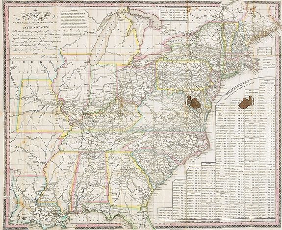
The Traveller's Guide. A Map Of The Roads, Canals And Steam Boat Routes Of The United States ... Designed for the use of Travellers, By H.S. Tanner. |
||||||||||||||||||||
|
||||||||||||||||||||
|
|
||||||||||||||||||||
$2750 / ≈ €2417This item is available for immediate sale! Questions before Buying ?
We are happy to answer your questions. |
My Collection +
Add this or any of your favorite items in one place. If you want to save the items permanently, you have to sign in or create an account first. |
|||||||||||||||||||
Description
Rare first edition of Tanner's travel map in pocket map form, in it original red leather covers, with the map and no text, as issued. Ristow says the first edition was 1834, and while that was the first issue of the enlarged guide with text, this 1825 map is from the same plate as the 1834 map and thus should be seen as the first edition of the guide.
The entire lower right corner of the map is taken up with lists of "Steam Boat Routes Throughout the United States," which are keyed to letters in the map margins. In the 1834 and later editions, these lists are replaced with inset maps of U.S. cities, and the lists are given, along with added stage and railroad routes, in the body of the text.
This interesting early map of the U.S. still shows the Five Civilized Tribes of the Indian Nation in their respective locations throughout the southeast. The western edge of the new country is sparsely populated, and the Oregon Territory begins just above Missouri.
Complete title: THE TRAVELLER'S GUIDE. A MAP OF THE ROADS, CANALS AND STEAM BOAT ROUTES OF THE UNITED STATES: WITH THE DISTANCES FROM PLACE TO PLACE CAREFULLY NOTICED, Including A Series Of Tables Showing The Routes Pursued By The Various Steam Boats, And The Distances Between Important Places Throughout The Country. Designed For The Use Of Travellers, By H. Tanner.
In lower margin : Published by H.S. Tanner, 177 Chestnut St. Philadelphia. Entered 21st day of May 1825, by H.S. Tanner ? Pennsylvania.
Inside of cover with brown ink "Boston, January 1st, 1829. Price $ 1."
Reference: A List of Maps of America in the Library of Congress, p. 884, Phillips, P.L, Government Printing Office, Washington, 1901, American Maps and Mapmakers, Chapter 13, Ristow, George, Wayne State University Press, Detroit, 1985
FAQ - Guarantee - Shipping
Buying in the BuyNow Gallery
This item is available for immediate purchase when a "Add to Cart" or "Inquire Now" button is shown.
Items are sold in the EU margin scheme
Payments are accepted in Euros or US Dollars.
Authenticity Guarantee
 We provide professional descriptions, condition report (based on 45 years experience in the map business)
Paulus Swaen warrants the authenticity of our items and a certificate of authenticity is provided for each acquired lot.
Condition and Coloring
We indicate the condition of each item and use our unnique HiBCoR grading system in which four key items determine a map's value: Historical Importance, Beauty, Condition/Coloring and Rarity.
Color Key
We offer many maps in their original black and white condition. We do not systematically color-up maps to make them more sellable to the general public or buyer.
Copper engraved or wood block maps are always hand colored. Maps were initially colored for aesthetic reasons and to improve readability. Nowadays, it is becoming a challenge to find maps in their original colors and are therefor more valuable.
We use the following color keys in our catalog:
Original colors; mean that the colors have been applied around the time the map was issued.
Original o/l colors; means the map has only the borders colored at the time of publication.
Colored; If the colors are applied recently or at the end of the 20th century.
Read more about coloring of maps [+]
Shipping fee
A flat shipping fee of $ 30 is added to each shipment by DHL within Europe and North America. This covers : International Priority shipping, Packing and Insurance (up to the invoice amount).
Shipments to Asia are $ 40 and rest of the world $50
We charge only one shipping fee when you have been successful on multiple items or when you want to combine gallery and auction purchases.
Read more about invoicing and shipping
FAQ
Please have a look for more information about buying in the BuyNow gallery
Many answers are likely to find in the general help section.
My Collection+
![]()
With My Collection+ you can collect all your favorite items in one place. It is free, and anyone can create his or her virtual collection.
Unless you are logged in, the item is only saved for this session. You have to be registed and logged-in if you want to save this item permanently to My Collection+.
Read More[+]
Register here, it is free and you do not need a credit card.
Add this item to
My Collection+
or click the following link to see My Collection+.
| Digital Image Download | |
|
Paulus Swaen maintains an archive of most of our high-resolution rare maps, prints, posters and medieval manuscript scans. We make them freely available for download and study. Read more about free image download |
Click the image for a free small image download. |
In accordance with the EU Consumer Rights Directive and habitually reside in the European Union you have the right to cancel the contract for the purchase of a lot, without giving any reason.
The cancellation period will expire 14 calendar days from the day after the date on which you or a third party (other than the carrier and indicated by you) acquires, physical possession of the lot. To exercise the right to cancel you must inform Paulus Swaen Inc, of your decision to cancel this contract by a clear statement (e.g. a letter sent by post, or e-mail.
To meet the cancellation deadline, it is sufficient for you to send your communication concerning your exercise of the right to cancel before the cancellation period has expired.
Recently Viewed

The Traveller's Guide. A Map Of The Roads, Canals And Steam Boat Routes Of The United States ... Designed for the use of Travellers, By H.S. Tanner.
Rare first edition of Tanner's travel map in pocket map form, in it original red leather covers, with the map and no text, as issued. Ristow says the first edition was 18...
Date: Philadelphia, 1825
