Browse Listings
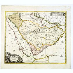
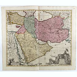
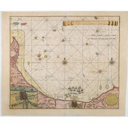
Arabiae Felicis, petrae et desertae.
A very striking map with a finely decorated title cartouche, published by Valk & Schenk, utilizing Jansson's original plate. Interestingly, this map uses the names th...
Date: Amsterdam, 1720

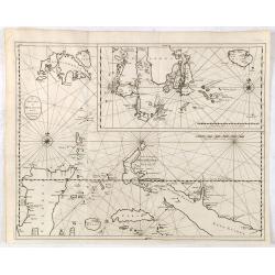
Carte des Principales Ports de Mer Bancs de sable &c: qui sont dans la Mer Rouge..
Some cities existed along the western coast of the Arabian peninsula, where they served as entrepots for transcontinental trade between Europe and Asia. Mecca, founded by...
Date: Amsterdam, 1720

Stoel des Oorlogs in America Waar in Vertoont Werden Alle Desself Voornaamste Eylande . . .
Large impressive map of the West Indies with the Gulf of Mexico and Florida. The map shows prominently in the center Cuba, Haiti, the Bahamas and Florida, which is here m...
Date: Amsterdam, c. 1720

Vue et Description de Quelques-Uns des Principaux Forts des Hollandois dans les Indes .
Interesting sheet with seven detailed views illustrating the most important Dutch V.O.C. trading outposts and fortified colonial possessions in the East Indies, including...
Date: Amsterdam, 1720

Nova tabula geographica complectens borealiorem..
A finely engraved pair of maps designed to be cut and joined together to provide a continuous coastline of North America from the Carolinas to Newfoundland and along the ...
Date: Amsterdam 1720

Japonia Regnum.
It is the first map to correctly show Korea as a peninsula. The rare Covens and Mortier issue of this important map of Japan and Korea, originally published by Blaeu. Thi...
Date: Amsterdam, 1655 - 1720
![Spiegel der Reden Voor de Wanhopende Actionisten. [Mirror for the reason of the despairing stockbrokers. ]](/uploads/cache/28094-250x250.jpg)
Spiegel der Reden Voor de Wanhopende Actionisten. [Mirror for the reason of the despairing stockbrokers. ]
Text page with copper engraving (150 x 100mm.) taken from Het groote tafereel der dwaasheid : vertoonende de opkomst, voortgang en ondergang der actie, bubbel en windnego...
Date: Amsterdam, 1720

Carte de l'Ile de Java.
An inset plan of Batavia and clearly indicated rice fields, mountains, forests, towns in profile and even elephants suggest the wealth of detail found on this map. Modele...
Date: Amsterdam, 1720
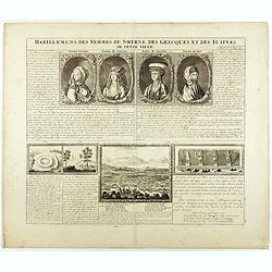
Habillement des femmes de Smyrnes, des Grecques et des Juifs de cette ville.
Four portraits of Smirne women in typical dress, each with a descriptive engraved text. From Chatelain's monumental 7 volume "Atlas Historique".Henri Abraham Ch...
Date: Amsterdam, 1720

A new map of the English Empire in America. . .
This fine English map of eastern North America including Canada engraved by John Harris and first published by Robert Morden. John Senex acquired and made minor alteratio...
Date: London, 1720
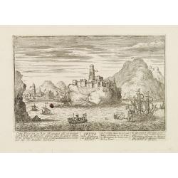
Ceuta Ville d'Afrique au D'estroit de Gibraltar.
A very RARE panoramic view of the city of Ceuta, including a numbered legend in both lower corners.Published by the brothers Chéreau, active in Paris at rue st.Jacques au...
Date: Paris c.1720
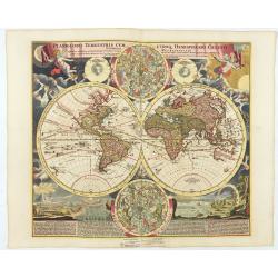
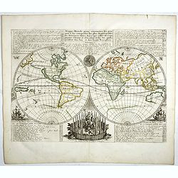
Planiglobii Terrestris Cum Utroq Hemisphaerio.
Vibrantly decorative world map surrounded by vivid engravings of natural phenomena such as waterspouts, a rainbow, earthquakes, and a volcano. Windheads occupy the starry...
Date: Nuremberg, c. 1720
Het Groote Tafereel der Dwaasheid.
AN EARLY ISSUE of this biting and vulgar satire on the Mississippi and South Sea Bubbles and an extraordinary visual record with 78 plates of the first banking crash, sho...
Date: Amsterdam, 1720

Vue et description des principales villes de l'Armenie et de la Georgie avec les habillements des femmes du pays, et ceux des prêtres et religieux armeniens. . .Tom: V N° 11 Pag: 28
View and description of the principal Armenian and Georgian cities with illustrations of Armenian women's garments as well as priests' and monks' clothing. The views are ...
Date: Amsterdam, ca 1720

Nostre Dame de Lorette.
A very RARE panoramic of Lorette and the church, including a numbered legend in both lower corners.The plate is numbered in black pencil in upper right corner.Published ...
Date: Paris c.1720
Het Groote Tafereel der Dwaasheid, vertoonende de opkomst, voortgang en ondergang der Actie, Bubbel en Windnegotie, in Vrankryk, Engeland, en de Nederlanden, gespleegt in den Jaare MDCCXX...
1720 - With 78 plates of the first banking crash, showing the shocking effects of the “South Sea Bubble” in France, England and Holland, and placing John Law with his Mis...
Date: Amsterdam, 1720
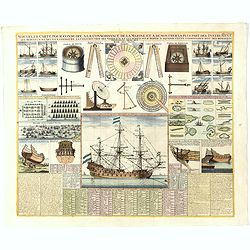
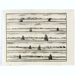
Nouvelle Carte pour conduire a la Connoissance de la Marine . . .
This is a fascinating folio sheet filled with engravings of ships and navigation instruments. At center is a large view of a frigate showing the rigging in great detail. ...
Date: Amsterdam, 1720
Selling price: ????
Please login to see price!
Sold in 2023

Imperii Sinarum nova descriptio.
Schenk and Valk's rare early 18th century issue of Janssonius milestone map of China, Korea and Japan after Martino Martini. Engraved by Johannes van Loon. The overall ba...
Date: Amsterdam, ca. 1720

Beschrijving Gezicht van den Ykant af bezyden den Schreiers hoex Toren langs de Keulsche en Geldersche Kaei naer de Nieuwe Markt
This large engraving (560x920mm.) comes from a are series of 25 beautiful large views of Amsterdam and gives a colorful picture of the life and business of the city at th...
Date: Amsterdam, ca. 1720

Norimberga.
A spectacular panoramic town-view of Nuremberg, with legends numbered from 1-39 in German. With the title in a banderol.After a design by Friedrich Bernhard Werner (1690...
Date: Augsburg, ca. 1720

Riga metropolis Livoniae.
A spectacular panoramic view of Riga, with legends numbered from a-z and 1-16 in German. With the title in a banderol.After a design by Friedrich Bernhard Werner (1690-1...
Date: Augsburg, ca. 1720
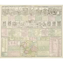
Kort Begryp van Duytsland, de drie Ryx Collegien in hunne Wapens en Zittingen. Kreits Verelingen en Aantekenigen door C. Specht't Utrectht.
Second state of this decorative table of family escutcheons, crests and coats of arms, for various German and Dutch princes and nobles of the 16th, 17th and 18th Centurie...
Date: Amsterdam, 1720
![Malines. [Mechelen]](/uploads/cache/13125-250x250.jpg)
Malines. [Mechelen]
A very RARE panoramic town view of Mechelen, including a numbered legend in the left lower corner.Published by the brothers Chéreau, active in Paris at rue st.Jacques au ...
Date: Paris, c.1720
![Waare afbeelding van den vermaarden Heer Quinquenpoix. [True portrait of the reknowed Mr. Quinquenpoix]](/uploads/cache/27965-250x250.jpg)
Waare afbeelding van den vermaarden Heer Quinquenpoix. [True portrait of the reknowed Mr. Quinquenpoix]
Page taken from Het groote tafereel der dwaasheid : vertoonende de opkomst, voortgang en ondergang der actie, bubbel en windnegotie, in Vrankryk, Engeland, en de Nederlan...
Date: Amsterdam, 1720

Nouvelle carte du Roiaume D'Alger divisée en toutes ses provinces, avec une partie due cotes D'Espagne . . .
Rare and detailed map of the coast of Algeria. Large inset map of the Bay of Alger (El-Jazir). Shows a coastline of Spain around Alicante. Two compass roses in the Medite...
Date: Amsterdam, 1720

Amsterdam Capitale de la Hollande.
A panoramic of Amsterdam seen from 't IJ. Set within a decorative border, printed from a separate plate. Rare.
Date: Leiden, 1720

Het Oost Indisch Huys op de Suyd hock..
A decorative print of the East Indian House , the headquarters of the V.O.C., a place for meeting, trading and storage of spices and ship equipment.The maps and charts we...
Date: Amsterdam, 1720
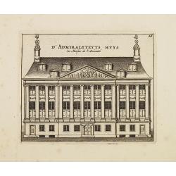
D' Admiralyteyts Huys - La maison de l'Amirauté.
Decorative print of the Admiralty House of the V.O.C., now-a-days Maritime Museum in Amsterdam.
Date: Amsterdam, c.1720
![Flessingue Ville de l'Ile de Walcheren. [Vlissingen]](/uploads/cache/13105-250x250.jpg)
Flessingue Ville de l'Ile de Walcheren. [Vlissingen]
A very RARE panoramic view of the city of Vlissingen. The plate is numbered in red pencil in the upper right corner.Engraved by Jean Crepy (the father), who was active as...
Date: Paris, 1690-1720

Carte de la Nouvelle France, ou se voit le cours des Grandes Rivieres de S. Laurens & de Mississipi..
Derived from de Fer's 1718 map, from west of the Mississippi it contains a mass of inland detail with notes and vignettes of the indigenous peoples and fauna of North Ame...
Date: Amsterdam, 1720
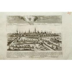
Utrecht.
A very RARE panoramic view of Utrecht, including a numbered legend in the lower part.Engraved by Jean Crepy (the father) who was active as an engraver and publisher at th...
Date: Paris, 1690-1720
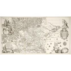
Diocesi Padovana Con Tutta La Sua Estensione Ne Vicini Territori.
This large map depicts the entire extent of the Diocese of Padua and the surrounding territories, with a detailed topographical rendering. It features rich Baroque ornam...
Date: Padova, 1720

Waere Affbeeldinge Wegens het Casteel ende Stadt BATAVIA Gelegen opt Groot Eylant Java.
A good impression of this finely engraved and detailed plan of Batavia, present-day Jakarta, the Dutch center of trading activities in the East Indies. Copied after Cleme...
Date: Amsterdam, 1721
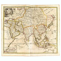
A New Map of Asia from the latest Observations Most Humbly Inscrib'd to the Right Honbl. George Earl of Warrington &c.
Fine map of Asia, with decorative title cartouche flanked by two figures in Asian dress, along with flora and fauna of the continent., based on the work of Guillaume De L...
Date: London, 1721
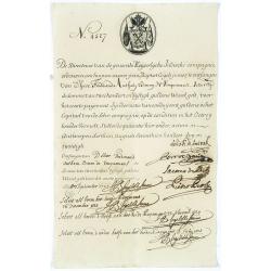
Very rare share in the Ostend Company. (4527)
Upper left hand corner share number 4527 in manuscript. In top emblem of the Ostend Company in copper engraving. Text: De Directeurs van de generale Keijserlijche- Indisc...
Date: Antwerp / Ostend 1723
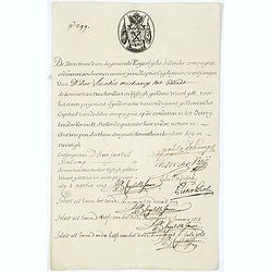
Very rare share in the Ostend Company. (299)
Upper left hand corner share number "299" in manuscript. In top emblem of the Company in copper engraving. Text: " De Directeurs van de generale Keijserlij...
Date: Antwerp / Ostend, 1723

Plan de la ville de Malthe ses Forts, ses Nouvelles Fortiffications. . .
Detailed plan of Valletta. In upper right corner a key (A-Z & 1-32) to the principal places in town. Prepared by N.de Fer and re-issued by Danet.
Date: Paris, 1723
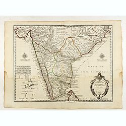
Carte des Cotes de Malabar et de Coromandel..
Detailed and attractive map of India and the northern tip of Sri Lanka. With decorative title cartouche and two compass roses.Rare edition with address : A Paris chez l’A...
Date: Paris, 1723
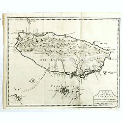
Kaart van het Eyland Formosa en de Eylanden van Piscadores.
The earliest printed map of Taiwan or Formosa. Oriented to the east, with north at the left, covering the entire island and the nearby Pescadores, now known as the Penghu...
Date: Amsterdam, 1724
![[The Philippines]](/uploads/cache/49201-250x250.jpg)
[The Philippines]
Fine chart depicting the Islands of the Philippines. Little interior detail is given but the coastlines, settlements and principal coastal features are identified. An att...
Date: Amsterdam, 1724
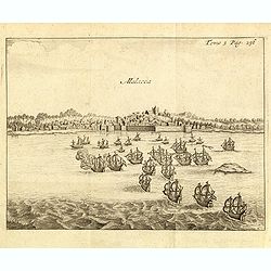
Malacca.
Fine print showing Dutch vessels offshore the city of Malacca, between Singapore to its south and Kuala Lumpur, the capital of Malaysia to its north.From the French reiss...
Date: Amsterdam, J.F. Bernard, 1725
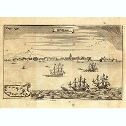
Ormus. (Hormuz)
This very interesting early engraving shows the ships of the Dutchman Van den Broecke, who in December 1628 left his directorship in Surat. Before returning to Batavia he...
Date: Amsterdam, F. Bernard, 1725
![[12 volumes] Recueil des voyages qui ont servi à l'établissement et aux progrez de la Compagnie des Indes Orientales, forméedans les Provinces-Unies des Païs-Bas...](/uploads/cache/43700-250x250.jpg)
[12 volumes] Recueil des voyages qui ont servi à l'établissement et aux progrez de la Compagnie des Indes Orientales, forméedans les Provinces-Unies des Païs-Bas...
An important, richly illustrated compendium of the first Dutch voyages to East India, of great interest for the history and establishment of the Dutch global trade, parti...
Date: Rouen, Pierre Le Boucher, 1725
Nova Persiae Armeniae Natoliae et Arabiae.
1725 DE WIT, F. / OTTENS, R. / J. - Shows the Saudi Peninsula and the area east of Cyprus to Iran.
Date: Amsterdam, 1725

Carte Marine De La Mer Caspiene levée suivant les ordres de S.M.Cz. En 1719, 1720 et 1721.
Detailed of the Caspian Sea, prepared by Karl van Verden in 1722. Van Verden was a Russian sailor and the Czar's Special Commander, who produced the first accurate map of...
Date: Paris, ca. 1725

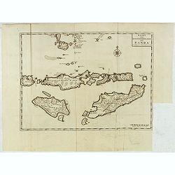
Nieuwe Caart der Eylanden van Banda.
Decorative map of the Banda Islands. Until the mid-19th century the Banda Islands were the world's only source of the spices nutmeg and mace, produced from the nutmeg tre...
Date: Amsterdam, 1726
Kaart van de Zuyd-Wester Eylanden van Banda.
Early and detailed map of the Banda Islands, prepared by François Valentijn (1666–1727), a Dutch missionary who spent years in Amboina and traveled extensively through VO...
Date: Amsterdam, 1726

Nieuwe Kaart van het Eyland Sumatra..
Fine chart depicting the Island of Sumatra and the southern coasts of Malaysia from Quedo to Johore. North is orientated to the left of the page. Singapore is probably id...
Date: Amsterdam, 1726
De Landvoogdy der Moluccos met de Aangrenzende Eylanden . . .
Two charts on one sheet depicting the Moluccas islands. Little interior detail is given but the coastlines, settlements and principal coastal features are identified. To ...
Date: Amsterdam, 1726

Nieuwe kaart van 't Koninckryk Bengale. . .
Rare map Bangladesh with the Ganges delta, including Calcutta. Giving great detail with trade routes, European trade settlements, etc. Prepared by Joh. Van Leenen who was...
Date: Amsterdam, 1726
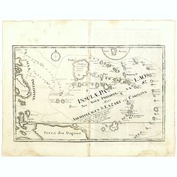
Insulae Palaos seu Novae Philippinae 87 Alias Archipelagus S. Lazari ven Carolinae . . .
Map of Philippine archipelago. Stöcklein's work is a compound of letters of the Jesuit missionaries from all over the world and here particularly the ones stationed at th...
Date: Augsburg, 1726
De Kust van Nova Guinea tot aan deze bogt . . .
De kust van Nova Guinea tot aan deze bogt.De Kust van Nova Guinea ofte Salomon Sweers hoek. Het Landt van Nova Guinea in de Groote Bocht daar wy vergeefs hoopten een doo...
Date: Amsterdam, 1726

Die Insel Formosa neu abgemessen auf Befehl Kaysers Kamhi.
One of the earliest obtainable printed maps of Taiwan or Formosa Island. It was issued around 1726 to illustrate Joseph Stöcklein's [Stoecklein] compilation of Jesuit mis...
Date: Augsburg, 1726
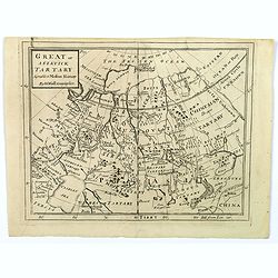
Great or Asiatick Tartary, Agreeable to Modern History.
A map from the Frozen Ocean in the north to Usbec Tartary in the south, from Moscow in the west to China Tartary and Peking in the east. Rivers and mountains feature prom...
Date: London, ca. 1727

Great or Asiatick Tartary, Agreable to Modern History.
Map of Tartary to Peking. The eastern coastline of Asia is almost flat, with no attempt to mark Kamchatka. The Caspian Sea in the lower left, with present-day Uzbekistan ...
Date: London, 1727
De Reede en stadt Batavia is geleegen aan de Noord Kust…
A chart of the bay of Batavia with in lower left corner a plan of Batavia (120x147mm). This very rare and influential chart gives a fine representation of Batavia, now kn...
Date: Amsterdam, 1728

Tabula Americae Specialis Geographica Regni Peru, Brasiliae, Terra Firmae & Reg: Amazonum, Secundum relationes de Herrera, de Laet & PP d Acuña & M. Rodriguez . . .
A good and clean copy of Homann's map of the northern part of South America. The map is on the Valley of the Amazon and delineates the Amazon and its labyrinth of tributa...
Date: Nuremberg, 1728

L'Asie suivant les nouvelles observations...
Uncommon edition of this map of Asia. From Le Nouveau Theatre du Monde, ou la Geographie Royale.The map is of interest for the use of Mer Orientale, the sea between Kore...
Date: Amsterdam, 1728

L'Inde de la le Gange, suivant les nouvelles observations...
Uncommon edition of this map of Malaysia, Thailand, Indo China and the Northern parts of the islands of Sumatra and Borneo. Singapore marked as Sincapour. With decorative...
Date: Amsterdam, 1728

Carte qui contient..Iles & Terres..L'Amerique..Jamaique..
Eight maps on one sheet. From Chatelain's Atlas Historique et Méthodique . Including maps of Bermuda, Jamaica, New England with Long Island, Carolina, Chesapeake and Dela...
Date: Amsterdam 1728
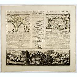
Genealogie des empereurs Mogols . . .
Text sheet with two inset maps of "Carte de l'empire du grand Mogol (122x158mm.) and inset map of Kahsmire "carte nouvelle du royaume de Kachemire" (120x15...
Date: Amsterdam, 1728

Carte nouvelle des Terres de Cucan..
Prepared by H.Reland (1676-1718) a professor active in Utrecht and specialized in Asian languages, geography and religions. His first map was a map of Japan copied after ...
Date: The Hague, 1728
![[Printed on silk] Nieuw Wassende Graaden Paskaart Vertoonende alle de bekende Zeekusten en Landen op den geheelen Aard Boodem of Werelt door Gerard van Keulen. . .](/uploads/cache/31640-250x250.jpg)
[Printed on silk] Nieuw Wassende Graaden Paskaart Vertoonende alle de bekende Zeekusten en Landen op den geheelen Aard Boodem of Werelt door Gerard van Keulen. . .
A very scarce and beautiful chart on Mercator's projection printed on silk. With the name of Gerard van Keulen and the privilege. The map shows great interior detail, inc...
Date: Amsterdam, 1728

Habillement de l'Empereur de la Chine & des Dames de son Palais..
This impressive engraving is a wonderful example of Chatelain’s elegant plates.Divided in 3 panels, showing examples of costumes of Chinese ladies and those of the king o...
Date: Amsterdam, ca. 1728

Carte du Gouvernement de Provence, suivant les nouvelles observations...
Fine copper engraved and decorative map of the Provence region in the south of France. It includes the cities of Nimes, Viviers, Avignon, Aix and Nice. The pictorial cart...
Date: Amsterdam 1728
![Lutece conquise par les François sur les Romains ou second plan de la ville de Paris [...] par M.L.C.D.L.M.](/uploads/cache/42141-250x250.jpg)
Lutece conquise par les François sur les Romains ou second plan de la ville de Paris [...] par M.L.C.D.L.M.
Engraved plan of Paris, published in "Traité de la police de Nicolas de Lamare". Oriented to the North with a compass rose and equipped with a double scale (400...
Date: Paris, 1729

Virginie, Grande Region l'Amerique Septentrionale...
Pierre van der Aa used the old copper plate of Meurs and re-did the engraving, changed the large pictorial cartouche, a new scale of German and French leagues is provided...
Date: Amsterdam, 1729
Historic Map - Naaukeurige Kaart Van Tartaryen, Soo als dat door W De Rubruquis doorreyst.
This attractive map published by Pieter van der Aa, shows Tartary abd the ancient Silk Road region. The map shows the track of William of Rubruck (Willem van Rubroeck or ...
Date: Amsterdam, 1713-1729

Histoire Naturelle, Civile, Et Ecclésiastique..'
First French edition, published by P. Gosse, J. Neaulme and B. Lakeman. The basic work on Japan from the second half of the 17th century when it was still forbidden for f...
Date: Amsterdam, 1729

Grande Pologne et Prusse avec les frontières de la Misnie, Lusace, Moravie et Lithuanie.
Detailed map of Poland and Prussia. Published by Pieter van der Aa who published a.o. "Naauwkeurge versameling der gedenkwaardigste zee- en land-reysen", a seri...
Date: Leiden, 1729
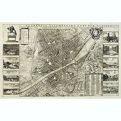
Florentia Pulcherrima et Ruriae Civitas.
Detailed bird's-eye view of the town of Florence in Tuscany region, first published in Frederick de Wit's rare town book. With two keys 1-17 and 1-228 to important spots ...
Date: Amsterdam, Leiden, 1697 / 1729
Mappe-Monde pour connoitre les progres & les conquestes..
Unusual double hemisphere map with California as an Island. Dutch text describes the expeditions and colonial possessions of the Dutch East India Company. The map origina...
Date: Amsterdam, 1729
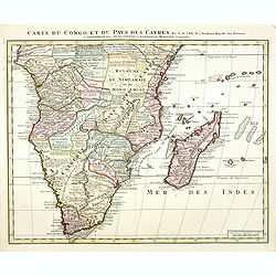
Carte du Congo et du Pays des Cafres. . .
Detailed copper-engraved map of southern Africa providing numerous particulars and comments concerning European trade, native kingdoms, and mineral wealth. Includes Madag...
Date: Amsterdam, c. 1730
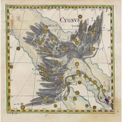
Cygnus.
Uncommon celestial print of Cygnus, published by Corbinianus Thomas in the Manuductio ad Astronomiam, Juxta modum Bayeri, Mathematici celeberrimi, concinnata, multis,…edi...
Date: Frankfurt / Leipzig, c.1730

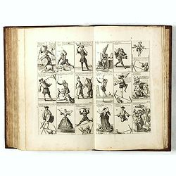
Rare collection of costume plates.
Rare collection of costume plates published in Augsburg by the famous publishers Martin Engelbrecht, Ioh. Georg Hertel and the Jeremias Wolff Heirs.Composition :2 plates ...
Date: Augsburg, ca. 1730
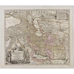
Imperii Persici in omnes suas Provincias . . . Exacte Divisi Nova Tabula Geographica. . .
Showing the eastern part of Turkey and Cyprus, Palestine, Persian Gulf, including Gulf of Oman, Caspian Sea, Iran and the north-west territories of India.Embellished with...
Date: Ausburg, 1730

Colossus Monarchic. Statua Danielis
Fantastic double page allegorical map of a colossus figure representing the great world empires as Daniel interpreted in Nebuchadnezzar's dream. The warrior stands stolid...
Date: Augsbourg, 1730

Cazal. (Casale Monferrato)
A rare panoramic of Casale Monferrato in the Piedmont region. Engraved by Pierre Aveline (Paris, c.1656 - 23 May 1722). He was also a print-publisher and print-seller. H...
Date: Paris, 1690-1730

Insularum Moluccarum Nova description.
Exquisite map of the famous Spice Islands based. This map was the first large-scale map of the region and depicts the islands which provided first the Portuguese and then...
Date: Amsterdam, 1730

Plan de la Baye de Ville Franche et de celle de St. Souspir.
An attractive chart centered on the Mediterranean. With scale and large compass-rose. Dated 1727, with the privilege of the King. From : Recueil des Plusieurs plans des p...
Date: Marseille, 1730
