Browse Listings in Atlases
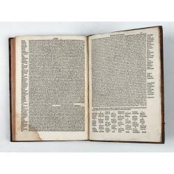
Strabo de situ orbis.
Rare post-incunable 1502 sixth edition of Strabo’s Geographica, translated from Ancient Greek to Latin as De Situ Orbis by Guarino da Verona and Gregorio Tifernate.The te...
Date: Venice, Bartolomeo de Zanis,14th day of January 1502
![Claudii Ptolemaei Alexandrini mathematicor[um] ...Octo libri Geographie. . .](/uploads/cache/62656-250x250.jpg)
Claudii Ptolemaei Alexandrini mathematicor[um] ...Octo libri Geographie. . .
Third edition of "Géographie" by Ptolemy and published in Strasbourg. Illustrated with 50 maps engraved in wood. One of the more important maps shows the earlie...
Date: Strasbourg, J. Grüninger, 1522

Itinerarium Sacrae Scripturae. Das ist: Ein Reisebuch...
Itinerarium Sacrae Scripturae. Das ist: Ein Reisebuch, Uber die gantze heilige Schrifft, in zwey Bücher geteilet... Zuvor gemehret mit einem Büchlein De monetis et mensur...
Date: Magdeburg, 1587
First German text edition of the Spieghel der Zeevaerdt…
First German edition including 47 charts in very fine contemporary colors and bound in a contemp. brown calf binding. The boards are richly blind stamped, with a design ...
Date: Amsterdam, 1593

Le Nouveau miroir des voiages marins de la navigation de la mer occidentale & orientale.
A second and final French edition of this important sea atlas. Two engraved frontispieces, figure with volvelle, full-page figure, 48 double-page charts (one numbered 19....
Date: Antwerp, Chez Iean Bellere, a l’Aigle d’or, l’An M.CCCCCC (1600

Nieuw Nederlandtsch Caertboeck. Waer in volkomentlijcker als oyt te voren vertoont werden de XVII. Nederlanden.
Rare first edition of this atlas of the provinces of the Netherlands, Belgium and Luxemburg. Engraved title page, with : "Gedruckt t' Amsterdam by Abraham Goos Plaet...
Date: Amsterdam, 1616
![[Two volumes, with two Leo maps] De Bello Belgico, Decas Prima / Decas Secunda.](/uploads/cache/48779-250x250.jpg)
[Two volumes, with two Leo maps] De Bello Belgico, Decas Prima / Decas Secunda.
With 2 engraved titles of the 'Leo Belgicus', with one paw resting on a shield bearing the title, large woodcut printer's device on the colophons, and 30 richly engraved ...
Date: Rome, Franciscus Corbelletus, 1632-1647

Diverses cartes et tables pour la géographie ancienne, pour la chronologie et pour les itinéraires et voyages modernes.
Edition without date. Variant edition containing three parts : "Cartes géographiques dressées pour bien entendre les Historiens… / La Chronologie en plusieurs Tables...
Date: Paris, l'Auteur, no date ca.1669
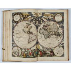
L’Atlas de la Mer ou Monde aquaticque.
Original blind-stamped vellum binding; attractive ORIGINAL HAND-COLOR in outline with cartouches, windroses and decoration in full original color; internally some usual m...
Date: Amsterdam, sur le Cay de Teexel, prez du Rams-Koy, au miroir de la Mer, 1670

French composite atlas made up of rare maps published by Parisian editors from the 17th century , mainly by G. Jollain including scarce maps of America.
A rare French composite atlas including 90 maps, published by Parisian publishers from the 17th century, mainly by Gérard I Jollain, or by maps bought from Dutch publishe...
Date: Paris, ca. 1675
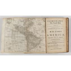
Cosmography in Four Books. Containing the Chorography and History of the Whole World: and all the Principal Kingdoms, Provinces, Seas,
Extensive description of the world by Peter Heylyn. Here the 6th edition corrected and enlarged by the author. Including 4 maps.The map of America showing California as a...
Date: London, 1682

A unique composite atlas with updated Porro maps.
Unique composite atlas containing in total 84 maps - 82 maps engraved by Girolamo Porro and heavenly reworked around 1686 and 2 newly engraved maps; Piccola Tartaria (Cr...
Date: Venice, 1686

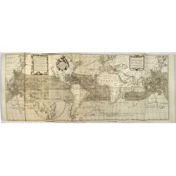
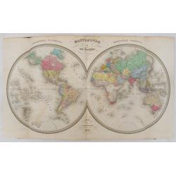
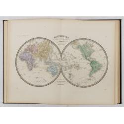
Le Nouveau et Curieux Atlas Geographique et historique, ou Le Divertissement des Empereurs, Roys, et Princes. Tant dans la Guerre que dans la Paix. Dédié A Son A.R. Monseigneur le Duc d'Orléans Regent du Roîaume de France.
Charming world atlas with double hemisphere world and the North American map feature the Island of California. In Asia and the Pacific, Australia is incompletely mapped a...
Date: Paris, 1719
![[12 volumes] Recueil des voyages qui ont servi à l'établissement et aux progrez de la Compagnie des Indes Orientales, forméedans les Provinces-Unies des Païs-Bas...](/uploads/cache/43700-250x250.jpg)
[12 volumes] Recueil des voyages qui ont servi à l'établissement et aux progrez de la Compagnie des Indes Orientales, forméedans les Provinces-Unies des Païs-Bas...
An important, richly illustrated compendium of the first Dutch voyages to East India, of great interest for the history and establishment of the Dutch global trade, parti...
Date: Rouen, Pierre Le Boucher, 1725

Avantures du Sr. C. Le Beau, avocat en parlement ou Voyage curieux et nouveau parmi les Sauvages de l'Amérique Septentrionale. Dans lequel on trouvera une Description du Canada… Ouvrage enrichi d'une Carte et des figures necessaires.
A description of Huron, Iroquois, and Algonquin customs, written in charming style and based, the Author claims, on observations made on a trip to America in 1729." ...
Date: Amsterdam, 1738
![(Chatelain "Atlas Historique" in 7 volumes.]](/uploads/cache/47053X-250x250.jpg)
(Chatelain "Atlas Historique" in 7 volumes.]
Henri Abraham Chatelain, whose Atlas Historique was one of the most expansive encyclopedias of the age. First published in 1705, Chatelain's Atlas Historique was part o...
Date: Amsterdam: Chez Zacharie Châtelain, 1732 - 1739
Atlas van Zeevaert en Koophandel door de Geheele Weereldt.
Engraved frontispiece, title printed in red and black with engraved vignette, engraved dedication to the Dutch East India Company, 32 double-page engraved charts in very ...
Date: Amsterdam, 1745

't Hooge Heemraedschap van Delfland met alle de Steden, Dorpen, Ambachten, Litmaten, Polders, (etc.).
The so-called Kruquius map is a wall-map of the Delfland water board district. The map consists of 25 engraved map sheets. Several maps flanked by fine large armorial car...
Date: Delft, 1712-1750
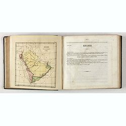
Introduction a la Geographie
Engraved title, with 91 double-page engraved maps mostly including European nations, but including World and continents, Turkey, the Holy Land, Persia, China, Japan, Egyp...
Date: Paris, 1756

Kort begrip der oude en nieuwe staatkundige Geographie: behelzende eene beschryving der heerschappyen, in welken de aarde verdeeld is, haare gelegenheid. . .
Sixth edition- Interesting geographical compendium, prepared by Johann Hubner en W.A. Bachiene. Of particular interest is the section starting with pages 589 with "O...
Date: Amsterdam, Covens / Mortier, Utrecht, Poolsum, 1758
![Ch'onha chido.[Atlas of all under Heaven]](/uploads/cache/44639composition-world-250x250.jpg)
Ch'onha chido.[Atlas of all under Heaven]
A late 18th-century Ch'onha chido atlas with 13 woodblock maps showing the World, China, Korea, Japan, Okinawa, and the 8 provinces. The seas are in black.Slight wear, co...
Date: Korea, ca. 1760
![Ch'onha chido. [Atlas of all under Heaven]](/uploads/cache/44640-250x250.jpg)
Ch'onha chido. [Atlas of all under Heaven]
A late 18th-century Ch'onha chido atlas with 10 woodblock maps showing the World, China, and the 8 province maps of Korea (Hamgyeong, Gangwon, Jeolla, Gyeongsang, Pyeonga...
Date: Korea, ca. 1780

Tablaeu de l'Univers premiere partie/ .. seconde partie.
Uncommon and interesting manual containing a double hemisphere world map (with fine outer decoration and showing an imagined great sea in West America, easily the size of...
Date: Luik, Belgium, 1784
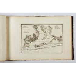
Atlas in elephant folio.
Most of D'Anville's atlases were made up for the individual customer, so no two appear alike. Many of the 59 pages are multi-sheet maps, so the actual map sheet count is ...
Date: Paris, 1771-1786
![CH'ONHA CHIDO [Atlas of all under Heaven]](/uploads/cache/33625-250x250.jpg)
CH'ONHA CHIDO [Atlas of all under Heaven]
The Ch’onha chido [Atlas of all under Heaven] is a late 18th century copy of the traditional Korean atlas produced in the early Choson dynasty (1392-1910). One of the map...
Date: Korea, ca. 1790
Grand atlas universel ou collection de cartes encyprotypes, générales et détaillées des cinq parties du monde.
Large folio atlas containing 8 general one-sheet maps, and 8 detailed four-sheet maps: Containing2 World maps- "Mappe-monde sur la projection de Mercator. Carte ency...
Date: Paris, Desray, 1816
Portulano de la Ameririca Setentrional construido en la direccion de tabajos.
The "Portulano de la America Setentrional", is an exceedingly rare Spanish sea atlas featuring charts of the Caribbean and the Gulf of Mexico. It was developed ...
Date: Madrid, 1818
Bibliomappe. Chronologie Historique et Géographique par MM. Année et Vivien bound with : Bibliomappe, ou Livre-Cartes: Leçons Méthodiques de Chronologie et de Géographie, . . .
With 67 maps (1 folding) by A.M. Perrot. Published in Paris. Most maps have original color. The atlas is complete very rare, as it was issued in 15 separate installments ...
Date: Paris, Renard, 1827 / 1824-1826

Les jeunes voyageurs en Europe, ou description raisonnée des divers pays compris dans cette partie du monde.
The second edition of this fine travel companion is illustrated with 16 very decorative maps, each map surrounded by local products and specialties of the region. Include...
Date: Paris, Thiériot, 1827

Manuscript atlas.
Charming manuscript atlas with 6 maps, pen and ink and water color, showing France, Europe, Africa, Palestine, North America and South America.The atlas is done by a youn...
Date: France, 1835
![Aou, Tōkei. Kokugun Zenzu [Atlas of Provinces and Counties of Japan]. (volume 1 only)](/uploads/cache/63619-250x250.jpg)
Aou, Tōkei. Kokugun Zenzu [Atlas of Provinces and Counties of Japan]. (volume 1 only)
First edition. Very attractive early Japanese Atlas of detailed maps of Japanese regions compiled by six Japanese civilians in the eighth year (1837) of the Tenpō era (1...
Date: [Nagoya]: Tōheidō, Tenpō 8 = 1837
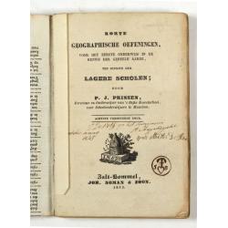
Korte geographische oefeningen voor het eerste onderwijs in de kennis der geheele aarde
Ilustrated with World Map, map of Europe, the Netherlands, Asia, Africa, North America, South America and Australia.Provenance : J.de Veth, October 1845.
Date: Zaltbommel, 1843
![[Collection of six maps of Australia and New Zealand.]](/uploads/cache/48412-250x250.jpg)
[Collection of six maps of Australia and New Zealand.]
Collection of maps including 6 engraved maps by 19th century German, French and English cartographers depicting Australia and New Zealand.This made to order atlas contain...
Date: Germany, 1832-1852
Volume III of the monumental atlas, ‘L’Orbe Cattolico ossia Atlante Geografico Storico Ecclesiastico’.
PETRI Girolamo's extremely rare Atlas volume III of the monumental atlas, ‘L’Orbe Cattolico ossia Atlante Geografico Storico Ecclesiastico’, respectively depicting eccl...
Date: Rome, 1858
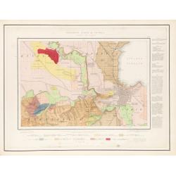
Geological Survey of Victoria.
The portfolio with the gold stamped title "Geological Survey of Victoria", contains 51 sheets maps. There is a pocket attached to the inside front cover contain...
Date: Mining and Geological Department, Melbourne, ca. 1864
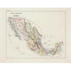
Atlas usuel de Géographie Moderne…
Complete with title page, contents page, and all 32 double-page maps of European and regional maps of the world, including Oceania, the Americas, Asia, Africa, etc. All i...
Date: Paris, c. 1865
Selling price: ????
Please login to see price!
Sold in 2024
Atlas de Géographie Physique, Politique, Ancienne et Moderne contenant les cartes générales et particulières toutes les parties du Monde.
Complete with title page, contents page, and all 35 double-page maps of European and regional maps of the world, including Oceania, the Americas, Asia, Africa, etc. All i...
Date: Paris, 1875
Selling price: ????
Please login to see price!
Sold in 2024

Atlas des Missions de la Société des Missions-Étrangères. . .
This scarce atlas contains maps showing the locations of the Catholic missions belonging to the Société des Missions Étrangères in Asia. It covers India, Burma, Siam, Mal...
Date: Lille, 1890
![[Atlas] Images du Monde. Atlas Illustré.](/uploads/cache/44610-250x250.jpg)
[Atlas] Images du Monde. Atlas Illustré.
In original green publishers green covered cloth covers, complete with a contents table and 33 pictorial maps of countries of the world (including continents and a world ...
Date: Paris, 1942
Selling price: ????
Please login to see price!
Sold in 2025
