1502 STRABON. - Rare post-incunable 1502 sixth edition of Strabo’s Geographica
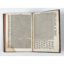


Strabo de situ orbis.
| Maker: | STRABON. | |
| Date: | Venice, Bartolomeo de Zanis,14th day of January 1502 | |
| Colored: | Uncolored. | |
| Size: | 290 x 210 mm / 11.4 x 8.3 inches | |
| Condition: | Small folio. [16], 150 leaves. Brown calf, red sprinkled edges, spine gilt divided into six panels (early 17th century binding). Binding professionally restored. First 4 leaves browning and water staining and 4 leaves at back brownish damp staining at bottom right-hand corner. Provenance: Kühnholtz-Lordat (engraved ex-libris). Binding slightly restored. First 4 leaves at front browning and water staining and 4 leaves at back brownish damp staining at bottom right-hand corners. | |
You can choose from more than 30,000 items from our BuyNow Catalog or Archive.
It's free, and you can delete items from your to your Collection+ anytime.
 Add/Remove



Description
Rare post-incunable 1502 sixth edition of Strabo’s Geographica, translated from Ancient Greek to Latin as De Situ Orbis by Guarino da Verona and Gregorio Tifernate.
The text contains woodcut initials and a table of names and subjects. Imprint from colophon. Edited by Antonio Mancinelli (as appears in the preface dated 1494).
The first ten books of Strabo’s work are here translated by Guarino Veronese (Guarino da Verona) (1374 – 1460), while the remaining seven books are translated by Gregorio Tifernate (1414 – 1462), both were influential humanist figures of the early Italian Renaissance.
Strabo, who died around 23, wrote an immense, precise Greek treatise on geography, as he was a firsthand witness: he went to Asia Minor, Armenia, Sardinia, Egypt, Corinth, Cyrene, and traveled partly in Italy. He also collected testimonies from others, such as on Etna. Eratosthenes, Polybius, Artemidoros, Posidonius, Apollodorus of Artemita for Parthian Asia, Demetrius of Scepsis and Apollodorus of Athens for Greece.
Books III to Book XVII, are devoted to the descriptive geography of regions of the empire.
Book XI of his Geographica includes a survey of northern and central Asia. The region he knew as Sogdiana, the country between the Oxus (Amu Darya) and the Iaxartes (Syr Darya), corresponds to the heart of modern Uzbekistan. Bactria lies to the south, Chorasmia to the west, and the steppe of the Sacae and Massagetae to the north and east.
Strabo describes a landscape of river valleys and oases surrounded by desert and steppe, and a mix of settled and nomadic peoples. He records how nomadic tribes, whom he names the Asii, Pasiani, Tochari and Sacarauli, overran the Greek kingdom of Bactria. He also repeats the debate over where the two great rivers ended. Ancient writers often assumed they flowed into the Caspian, but they actually drained toward the Aral Sea.
Sogdiana and Bactria (11.11): the heart of it. Sogdiana lies between the Oxus (Amu Darya) and Iaxartes (Syr Darya), roughly the core of modern Uzbekistan, with Maracanda (Samarkand) among the places he names, and he draws on accounts of Alexander’s campaigns here.
Sacae and Massagetae (11.8): the nomadic peoples beyond the Iaxartes, plus his account of the tribes (Asii, Pasiani, Tochari, Sacarauli) who overran Greek Bactria.
Margiane and Aria (11.10): the territory just to the south and west.
Oxus and Laxartes: the rivers and their supposed courses toward the Caspian Sea are discussed across these chapters.
Chorasmia(Khwarezm), in western modern Uzbekistan, appears only briefly, in the context of the Massagetae and the Oxus.
Strabo compiled his account from earlier Greek writers, especially the historians of Alexander the Great and geographers such as Eratosthenes and Apollodorus of Artemita. Alexander’s campaigns of 329-327 BC gave Greek readers their first detailed knowledge of the region. His army crossed the Oxus, took Maracanda (Samarkand) and fought a long, difficult war against the Sogdian leader Spitamenes. It also founded a city on the Iaxartes, which the Greeks treated as the edge of the civilized world.
Provenance: Kühnholtz-Lordat (with engraved ex-libris).
Strabo (Strabon) (c. 64 BC-c. AD 24)
No exact dates are known, but we assume Strabon was born c. 64 or 63 BC in Amaseia, in Pontus (modern Amasya, Turkey), into a wealthy Greek family with ties to the Mithridatic court. He died c. AD 24 or later. The latest datable events in the Geographica fall around AD 23, so scholars usually place his death shortly afterward.Strabo wrote the only surviving ancient geography to cover the whole known world, from Spain to India and from the Black Sea to Ethiopia. Its seventeen books combine physical description, history, ethnography and myth. Latin translations brought the work to Western Europe in the 15th century; Aldus printed it in Greek in Venice in 1516, and it shaped Renaissance cartography. Mapmakers from Ortelius onward cited it constantly, and its descriptions underlie many early reconstructions of the ancient world.
For readers today, Strabo’s account is a valuable record of how Hellenistic geographers understood Central Asia. It also shows why Sogdiana and Bactria remained familiar names on European maps for centuries.
FAQ - Guarantee - Shipping
This item is available for immediate purchase when a "Add to Cart" or "Inquire Now" button is shown.
Items are sold in the EU margin scheme
Payments are accepted in Euros or US Dollars.
Authenticity Guarantee
 We provide professional descriptions, condition report (based on 45 years experience in the map business)
Paulus Swaen warrants the authenticity of our items and a certificate of authenticity is provided for each acquired lot.
Condition and Coloring
We indicate the condition of each item and use our unnique HiBCoR grading system in which four key items determine a map's value: Historical Importance, Beauty, Condition/Coloring and Rarity.
Color Key
We offer many maps in their original black and white condition. We do not systematically color-up maps to make them more sellable to the general public or buyer.
Copper engraved or wood block maps are always hand colored. Maps were initially colored for aesthetic reasons and to improve readability. Nowadays, it is becoming a challenge to find maps in their original colors and are therefor more valuable.
We use the following color keys in our catalog:
Original colors; mean that the colors have been applied around the time the map was issued.
Original o/l colors; means the map has only the borders colored at the time of publication.
Colored; If the colors are applied recently or at the end of the 20th century.
Read more about coloring of maps [+]
Shipping fee
A flat shipping fee of $ 30 is added to each shipment by DHL within Europe and North America. This covers : International Priority shipping, Packing and Insurance (up to the invoice amount).
Shipments to Asia are $ 40 and rest of the world $50
We charge only one shipping fee when you have been successful on multiple items or when you want to combine gallery and auction purchases.
Read more about invoicing and shipping
FAQ
Please have a look for more information about buying in the BuyNow gallery
Many answers are likely to find in the general help section.
My Collection+

With My Collection+ you can collect all your favorite items in one place. It is free, and anyone can create his or her virtual collection.
Unless you are logged in, the item is only saved for this session. You have to be registed and logged-in if you want to save this item permanently to My Collection+. Read More[+]
Register here, it is free and you do not need a credit card.
Add this item to My Collection+ or click the following link to see My Collection+.
|
Digital Image Download Paulus Swaen maintains an archive of most of our high-resolution rare maps, prints, posters and medieval manuscript scans. We make them freely available for download and study. Read more about free image download |
Click the image for a free small image download. |


YOUR RIGHT TO CANCEL THE PURCHASE OF A LOT
In accordance with the EU Consumer Rights Directive and habitually reside in the European Union you have the right to cancel the contract for the purchase of a lot, without giving any reason.
The cancellation period will expire 14 calendar days from the day after the date on which you or a third party (other than the carrier and indicated by you) acquires, physical possession of the lot. To exercise the right to cancel you must inform Paulus Swaen Inc, of your decision to cancel this contract by a clear statement (e.g. a letter sent by post, or e-mail.
To meet the cancellation deadline, it is sufficient for you to send your communication concerning your exercise of the right to cancel before the cancellation period has expired.
