Browse Listings in Asia
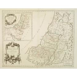
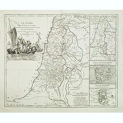
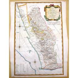
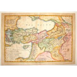
La Judée ou Terre Sainte divisée en ses douze Tribus..
A finely engraved and uncommon map depicting the division of the Holy Land into twelve tribes. In upper left hand corner inset map of land of Canaan.Venetian edition of G...
Date: Venice, 1776 - 1784
Selling price: ????
Please login to see price!
Sold in 2008
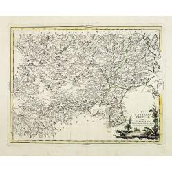
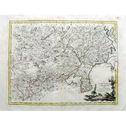
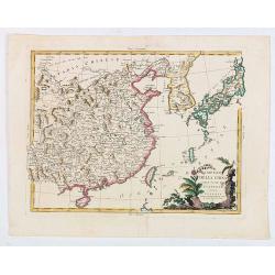
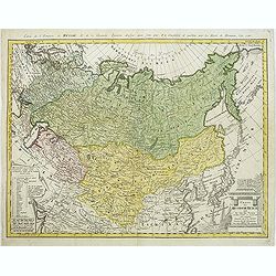
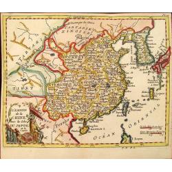
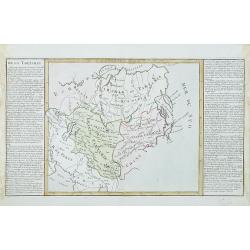
La Tartaria Chinese.
With decorative title cartouche. Covering north eastern part of China, Korea and Hokkaido (here called Jeso-Gasima ).
Date: Venice, 1784
Selling price: ????
Please login to see price!
Sold in 2008
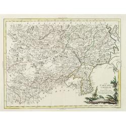
La Tartaria Chinese.
With decorative title cartouche. Covering north eastern part of China, Korea and Hokkaido (here called Jeso-Gasima, Tartary including the Gobi Desert, also Peking and the...
Date: Venice, 1784
Selling price: ????
Please login to see price!
Sold in 2010
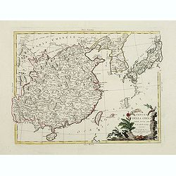
Impero delle china colle isole del Giappone. . .
Large copper-engraved map by Zatta, published in the monumental "Atlante Novissimo" in Venice. Shows Japan, Korea and China with Formosa in much detail. Handsom...
Date: Venise, 1784
Selling price: ????
Please login to see price!
Sold in 2011
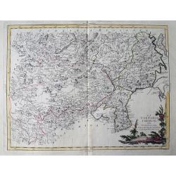
LA TARTARIA CHINESE
Attractive copper engraved map of the Far East covering parts of China, Korea, Mongolia, Russia and Japan (Jeso-Gasima). Includes the Chinese Wall, the Gobi desert, Lake ...
Date: Venice, 1784
Selling price: ????
Please login to see price!
Sold in 2011
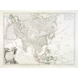
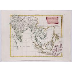
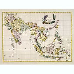
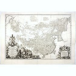
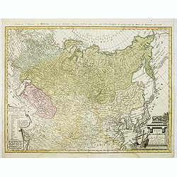
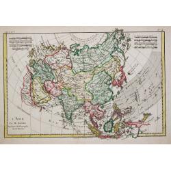
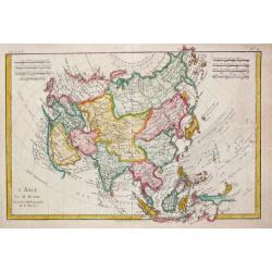
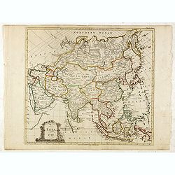
L'Asie divisée en ses principaux Etats..
Finely and crisply engraved map of Asia, decorated with an ornamental title cartouche in the lower left corner. Noteworthy topographical detail is shown. Shows New Guinea...
Date: Venice, 1776 - 1784
Selling price: ????
Please login to see price!
Sold in 2013
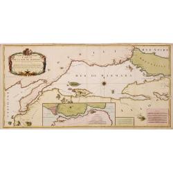
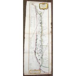
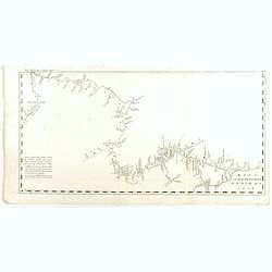
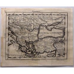
Carte de la Mer de Marmara du Canal des Dardanelles et de Celui de Constantinople. Levée sur les lieux en 1776
Detailed separately published engraved map in two sheets joined of the Sea of Marmara with in lower part inset map of Bospohrus, Carte de la ville de Constantinople et du...
Date: Paris, Foucherot, Delamarche, 1784
Selling price: ????
Please login to see price!
Sold in 2014
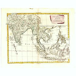
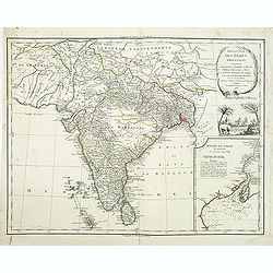
Le Indie Orientali E Il Loro Arcipelago . . .
Striking map of the region from the Gulf of Bengal to Hainan, centered on the Malay Peninsula, Straits of Malacca, Sumatra, Java and Philippines.The map was issued in Zat...
Date: Venise, 1784
Selling price: ????
Please login to see price!
Sold in 2018
LE INDIE ORIENTALI E IL LORO ARCIPELAGO.
A striking regional map, extending from the Phillipines and Moluccas to India and the Maldives, and north to Tibet. Decorative scroll title cartouche.From Zatta's monumen...
Date: Venise, 1784
Selling price: ????
Please login to see price!
Sold in 2017
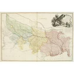
Carte Generale du Cours du Gange et du Gagra. . .
A large chart with six inset maps printed on one sheet by the Jesuit Joseph Tiefentaller in the latter half of the eighteenth century. The map is in French and in Persian...
Date: Paris ca 1784
Selling price: ????
Please login to see price!
Sold in 2023
LA TARTARIA CHINESE.
An attractive copper engraved map of the Far East covering parts of China, South Korea, Mongolia, Russia and Japan (Jeso-Gasima). Includes the Chinese Wall, the Gobi dese...
Date: Venice, 1784
Selling price: ????
Please login to see price!
Sold in 2019
L' ASIE divisee en ses principaux ETATS.
A detailed map of Asia from Janvier's 'Atlas Moderne'. Original coloring and new coloring on the decorative cartouche.
Date: Paris, 1784
Selling price: ????
Please login to see price!
Sold in 2019
Empero Della China Giappone.
Fine map of China, Korea and Japan. Shows administrative boundaries, major cities, villages, rivers and mountains. Map from "Atlas Novissimo" printed in Venice ...
Date: Venise, 1784
Selling price: ????
Please login to see price!
Sold in 2020
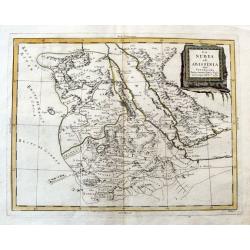
La Nubia ed Abissinia.
An Italian copper engraved map of the Red Sea and its coasts, including parts of Egypt and Arabia. Shows Mecca. With many place names, lakes, rivers, etc.
Date: Venice, 1784
Selling price: ????
Please login to see price!
Sold in 2020
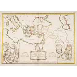
Carte des Régions et des Lieux dont il est parle..
Covers the region of the eastern Mediterranean through the Caspian Sea, showing the region described in the New Testament. Inset plans of Jerusalem and Judea. Three decor...
Date: Paris 1785
Selling price: ????
Please login to see price!
Sold
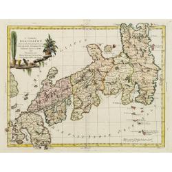
L'Impero del Giapon diviso in sette principali parti cive..
The map of the Japanese Empire published by Antonio Zatta (1757-97) continued to show most of the inaccuracies of earlier eighteenth-century maps.
Date: Venice 1785
Selling price: ????
Please login to see price!
Sold in 2008
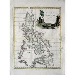
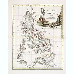
Isole Filippine
Important large map of the Philippines by Zatta published in his "Atlante Novissimo". Very detailed with even tiny islands shown and named. Decorative title car...
Date: Venice, 1785
Selling price: ????
Please login to see price!
Sold in 2008
Carte de la ville de constantinople et du Bosphore de thrace 1785.
Detailed plan of Istanbul and the river Bosporus till the Black Sea. Taken from a larger map published by P.F. Tardieu and engraved by J. B. L. Aubert.
Date: Paris, 1785
Selling price: ????
Please login to see price!
Sold in 2008
Carte D'Asie Divisée en ses Principaux Etats. . .
Uncommon and decorative "carte à figures" wall map, prepared by Cloued, with superb decoration. The map is interesting as it shows Korea in the d'Anville type ...
Date: Paris, 1785
Selling price: ????
Please login to see price!
Sold
L'Impero del Giapon diviso in sette principali parti cive..
The map of the Japanese Empire published by Antonio Zatta (1757-97) continued to show most of the inaccuracies of earlier eighteenth-century maps.
Date: Venice, 1785
Selling price: ????
Please login to see price!
Sold in 2011
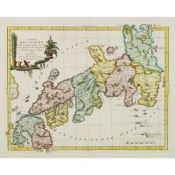
L' Impero del Giapon diviso in sette principali parti cioè Ochio Quanto Jetsegen Jetsen Jamaisoit, Xicoco e Xmo. . .
The map of the Japanese Empire published by Antonio Zatta (1757-97) continued to show most of the inaccuracies of earlier eighteenth-century maps.To the left the tip of S...
Date: Venice, 1785
Selling price: ????
Please login to see price!
Sold in 2015
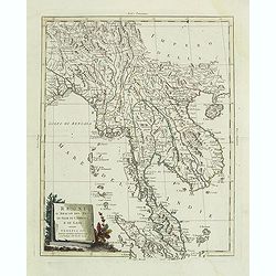
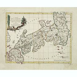
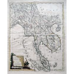
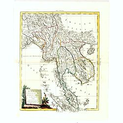
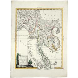
Regni D'Aracan Del Pegu Di Siam Di Camboge E Di Laos . . . 1785
Striking map of the region from the Gulf of Bengal to Hainan, centered on the Malay Peninsula, Straits of Malacca and most of Sumatra.The map was issued in Zatta's "...
Date: Venise, 1785
Selling price: ????
Please login to see price!
Sold in 2011
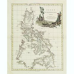
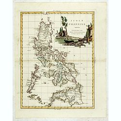
Isole Filippine.
One of the most decorative and sought after separate maps of the Philippines, based on the very rare map of Velarde. Covers all of the islands with remarkable detail. Dec...
Date: Venise, 1785
Selling price: ????
Please login to see price!
Sold in 2011
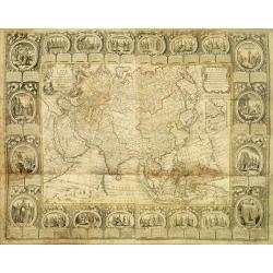
Carte D'Asie Divisée en ses Principaux Etats. . .
Uncommon and decorative carte à figures wall map, prepared by Cloued, with superb decoration. The map is interesting as it shows Korea in the d'Anville type with labelin...
Date: Paris, 1785
Selling price: ????
Please login to see price!
Sold
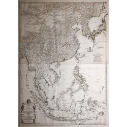
Indie Orientali di Quà e di la Dal Gange col Loro Arcipelago.
Fine almost wall sized map of South east Asia, including Formosa, New Guinea, the Maldives and the Indus delta. From his "Atlante Novissimo, illustrato ed accresciut...
Date: Venice, ca. 1779 - 1785
Selling price: ????
Please login to see price!
Sold in 2013
Isole Filippine.
One of the most decorative and sought after separate maps of the Philippines, based on the very rare map of Velarde. Covers all of the islands with remarkable detail. Dec...
Date: Venise, 1785
Selling price: ????
Please login to see price!
Sold in 2013
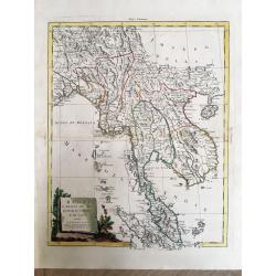
Regni D'Aracan Del Pegu Di Siam Di Camboge E Di Laos.
Fantastic copper engraved map of Burma, Thailand, Cambodia, Vietnam, Hainan, Straits of Malaca, the Malay Peninsula, and parts of Sumatra. Also with the Andaman, Nicobar,...
Date: Venice, 1785
Selling price: ????
Please login to see price!
Sold in 2013
Isole Filippine.
One of the most decorative and sought after separate maps of the Philippines, based on the very rare map of Velarde. Covers all of the islands with remarkable detail. Dec...
Date: Venise, 1785
Selling price: ????
Please login to see price!
Sold in 2015
Regni D'Aracan Del Pegu Di Siam Di Camboge E Di Laos . . . 1785.
Striking regional map, extending from the Philippines and Moluccas to India and the Maldives, and north to Tibet. Decorative scroll title cartouche.
Date: Venise, 1785
Selling price: ????
Please login to see price!
Sold in 2017
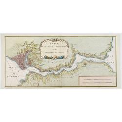
Sketch of the Typa and Macao.
A map of the environs of the Portuguese settlement of Macao in the Far East. The map shows a small town plan of Macao, nearby rocks, shoals depth soundings, and a few nav...
Date: London, 1785
Selling price: ????
Please login to see price!
Sold in 2020
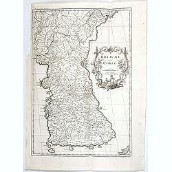
Royaume de Corée.
One of the earliest separate maps of Korea. The map engraved by the master engraver Delahaye, with a quite elaborately pictorial cartouche, engraved by G.Kondet. Jean Bap...
Date: Paris, Ph.-D. Pierres, Clousier [- Moutard], 1785
Selling price: ????
Please login to see price!
Sold in 2017
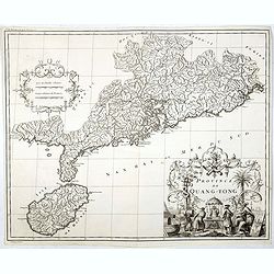
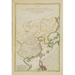
Province de Quang-Tong.
Very detailed map of Hong Kong and its surroundings.The map engraved by the master engraver Delahaye, with a quite elaborately pictorial cartouche, engraved by D. Sorniqu...
Date: Paris, Ph.-D. Pierres, Clousier [- Moutard], 1785
Selling price: ????
Please login to see price!
Sold in 2017
Carte la plus generale et qui comprend la Chine, la Tartarie chinoise et le Thibet. . .
With a quite elaborately pictorial cartouche, engraved by G.Kondet. Very detailed map of China, Tibet and Korea. Jean Baptiste Bourguignon d' Anville (1697-1782), French ...
Date: Paris, Ph.-D. Pierres, Clousier [- Moutard], 1785
Selling price: ????
Please login to see price!
Sold in 2017
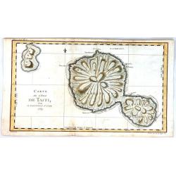
Carte de l'isle de Tahiti.
This chart of the islands of Tahiti is from James Cook’s first voyage, and is one of the earliest depicting the island.It is engraved to show the islands unique mountai...
Date: London, 1785
Selling price: ????
Please login to see price!
Sold in 2017
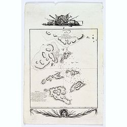
Sketch of the Typa and Macao.
A map of the environs of the Portuguese settlement of Macao in the Far East.
Date: London, 1785
Selling price: ????
Please login to see price!
Sold in 2018
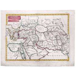
Carte de la Tartarie Orientale Manchuria China.
A fine copperplate map of Manchuria China and parts of Siberia Russia by the cartographer Bellin in Paris in 1785. It is from the Italian edition.It features a decorative...
Date: Paris, 1785
Selling price: ????
Please login to see price!
Sold in 2019
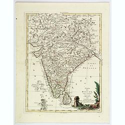
Stato del Mogol con l' Isole di Ceilan e Maldive.
A handsome map of India including Sri Lanka and the Maldives islands.
Date: Venice, 1785
Selling price: ????
Please login to see price!
Sold in 2018
Regni D'Aracan Del Pegu Di Siam Di Camboge E Di Laos.
An elegant map with a decorative cartouche.
Date: Venice, 1785
Selling price: ????
Please login to see price!
Sold in 2019
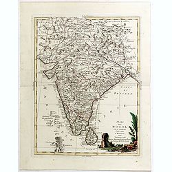
Stato del Mogol con l' Isole di Ceilan e Maldive.
A handsome map of India including Sri Lanka and the Maldives islands. With a nice decorative title cartouche in lower right corner. This lovely map incorporates plenty of...
Date: Venice, 1785
Selling price: ????
Please login to see price!
Sold in 2019
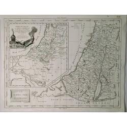
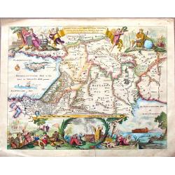
Terra di Canaan & Le Dodeci Tribu D'Isdraele.
An interesting Holy Land map with two parts, Israel with Canaan inserted to the top left. Filled with details of roads, towns and pictorial topography. The map features t...
Date: Venice, 1785
Selling price: ????
Please login to see price!
Sold in 2019
REGNI D'ARACAN DEL PEGU DI SIAM DI CAMBOGE E DI LAOS.
A striking engraved map of Burma, Thailand, Cambodia, Vietnam, Hainan, Straits of Malaca, the Malay Peninsula, and parts of Sumatra. Also with the Andaman, Nicobar, and M...
Date: Venice, 1785
Selling price: ????
Please login to see price!
Sold in 2019
ALEXANDER THE GREAT, Imperium ALEXANDRI MAGNI Per Europam, Asiam, et Africam.
A detailed map of the Empire of Alexander the Great, extending from Asia Minor and Greece to the regions around the Black Sea and Capian Sea, reaching the Indus River in ...
Date: Venice, 1785
Selling price: ????
Please login to see price!
Sold in 2022
Zweiter Theil der Karte von Asien, welcher China, einen Theil der Taterei, Indien jenseits des Ganges, die Inseln Sumatra, Iava, Borneo, Moluken, Philippinen, und Iapon enthaelt.
In common large map of South East Asia, printed from 2 plates on 2 sheets joined, after d'Anville and other sources by F.A. Schraembl, Vienna "1786".
Date: Vienna, after 1786
Selling price: ????
Please login to see price!
Sold in 2013
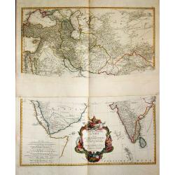
Erster Theil der Karte / von Asien / welche die Turkei, Arabien, Persien / Indien diesseits des Ganges / und einen Theil der Tartarei / anhalt.
A large and detailed map of the Middle East on two sheets. Embellished with a large decorative title-cartouche.
Date: Wien, 1786
Selling price: ????
Please login to see price!
Sold in 2019
A Map of Bengal, Bahar, Oude and Allahabad with Part of Agra and Delhi Exhibiting the Course of the Ganges from Hurdwar to the Sea..
Very large wall map extending from the Bay of Bengal in the South East as far as Tibet to the North and Gohud to the West.Engraved from the original drawing in the posses...
Date: London, 1786
Selling price: ????
Please login to see price!
Sold in 2022
Essai d'une nouvelle carte de la Mer Caspienne.
Map of the Caspian Sea including cities/towns and regions. Engraved by de master engraver Guill. De-la-Haye., dated "Novembre 1754". Jean Baptiste Bour...
Date: Paris, c. 1786
Selling price: ????
Please login to see price!
Sold in 2009
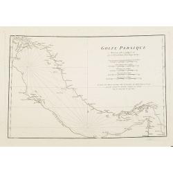
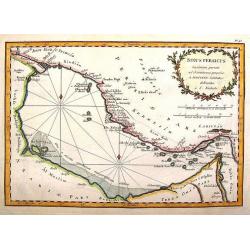
Golfe Persique Dressé en 1758 et publié en 76. . .
Map of the Persian Gulf including cities/towns and regions. Engraved by de master engraver Guill. De-la-Haye. Jean Baptiste Bourguignon d' Anville (1697-1782), French ca...
Date: Paris, c. 1786
Selling price: ????
Please login to see price!
Sold in 2009
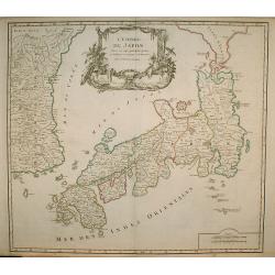
L' Empire Du Japon, divisé en sept principales . . .
Giles Didier Robert De Vaugondy's map of Japan in a second state, now with the date removed. Published by Charles Francois Delamarche, who acquired De Vaugondy's business...
Date: Paris, c. 1786
Selling price: ????
Please login to see price!
Sold in 2009
Charte das Russische Reich und die von den Tatarn. . .
Map showing the 'Russian Tartary' and as well the 'Asian Tartary', with French title in top.Title cartouche features a three-masted ship in the lower right corner and scr...
Date: Nuremberg, 1786
Selling price: ????
Please login to see price!
Sold in 2023
La Judée depuis le Retour de la Captivité, . . .
Decorative map of the Holy Land, with large insets of Ancient and Modern Jerusalem and the Holy Land at the time of the domination by the Turks. Large striking cartouche....
Date: Paris, Boudet, 1786
Selling price: ????
Please login to see price!
Sold in 2011
Presqu'Isle Des Indes Orientales, Comprenant l'Indostan ou l'Empire du Mogol. . .
Detailed map of India with inset map (220x155mm) of the mouth of the river Ganges. Identifies Delhi (or Jehan Abad), Agra (or Ekbar Abad), Bombay, Goa, Calcutta, Pondiche...
Date: Paris, Boudet, 1786
Selling price: ????
Please login to see price!
Sold in 2016
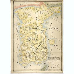
Chosen hachido no zu (or) Chosen koku zenzu (General map of korea)
Bold, beautifully colored road-map of Korea by the great Hayashi Shihei. Banned by the Edo government in 1792. A banned map !In 1785 Hayashi Shihei made the Sangoku Ts&am...
Date: Edo, Suharaya Shihei, in Temmei 5 or 1786
Selling price: ????
Please login to see price!
Sold
Charte das Russische Reich und die von den Tatarn. . .
Map showing the 'Russian Tartary' and the 'Asian Tartary', with the French title at the top. The title cartouche features a three-masted ship in the lower right corner,...
Date: Nuremberg, 1786
Selling price: ????
Please login to see price!
Sold in 2012
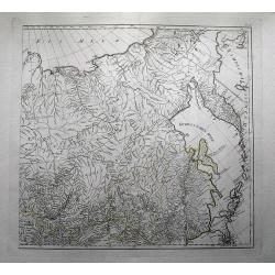
(untitled map of eastern Russia with Kamchatka )
Large and detailed map of eastern Russia with parts of Siberia including the lake Baikal by Franz Anton Schraembl (1751-1803). With a small part of today Mongolia and Chi...
Date: Vienna, c1786
Selling price: ????
Please login to see price!
Sold in 2012

Walvischvangst Te Firando in Japan.
A wonderful, rare and early copper engraving of Whaling in Hirado, Nagasaki, Japan. Published in "Nederlandsche Reizen" by Petrus Conradi in 1786.
Date: Amsterdam, 1786
Selling price: ????
Please login to see price!
Sold in 2016
Chosen hachido no zu (or) Chosen koku zenzu (General map of korea)
Bold, beautifully colored road-map of Korea by the great Hayashi Shihei. Banned by the Edo government in 1792. A banned map !In 1785 Hayashi Shihei made the Sangoku Tsura...
Date: Edo, Suharaya Shihei, in Temmei 5 or 1786
Selling price: ????
Please login to see price!
Sold in 2017
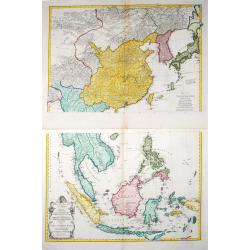
Zweiter Theil der Karte von Asien welcher China, einen Theil der Tartarei, Indien jenseits des Ganges, die Inseln Sumatra, Java . .
Two maps together depicting South East Asia / Zweiter Theil der Karte von Asien welcher China, einen Theil der Tartarei, Indien jenseits des Ganges, die Inseln Sumatra, ...
Date: Wien, 1786
Selling price: ????
Please login to see price!
Sold in 2021
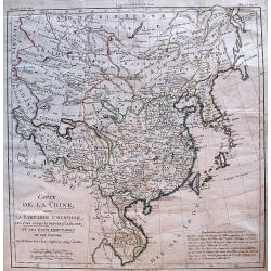
Carte de l'Empire de la Chine, de la Tartarie Chinoise, et du..
A fine map of China, Korea, Japan and Taiwan, prepared by R.Bonne and included in his Atlas Encyclopédique.. Rigobert Bonne (1727-1795) was engineer, mathematician and c...
Date: Paris 1787
Selling price: ????
Please login to see price!
Sold
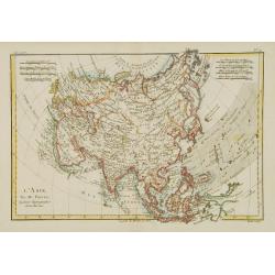
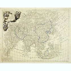
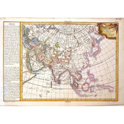
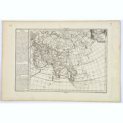
L'Asie.
Fine map of Asia, prepared by R.Bonne and included in his Atlas Encyclopédique.. Rigobert Bonne (1727-1795) was engineer, mathematician and cartographer, active in Paris...
Date: Paris 1787
Selling price: ????
Please login to see price!
Sold
L?Asie.
Rigobert Bonne (1727-1795), French cartographer. His maps are found in a.o. Atlas Moderne (1762), Raynal's Histoire Philos. du Commerce des Indes (1774) and Atlas Encyclo...
Date: Paris, 1787
Selling price: ????
Please login to see price!
Sold
L\'Empire de la Chine avec les Isles du Japon et la Coree.
Attractive map of China and neighbouring countries from Atlas ou Collection de Cartes Geographiques pour l'Intelligence du Voyageur Francois.
Date: Paris, 1787
Selling price: ????
Please login to see price!
Sold in 2012
L.Asie.
Rigobert Bonne (1727-1795), French cartographer. His maps are found in a.o. Atlas Moderne (1762), Raynal's Histoire Philos. du Commerce des Indes (1774) and Atlas Encyclo...
Date: Paris, 1787
Selling price: ????
Please login to see price!
Sold in 2019
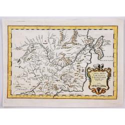
De la Tartarie
Map including the different regions of Tartary. Map centered on the Baikal Lake and the Karzana Lake. In the right and left margins, there are a long explication text. Je...
Date: Paris, 1787
Selling price: ????
Please login to see price!
Sold in 2010
Carte de la Chine.
Uncommon French map of China and adjacent tributary states.
Date: Paris, 1787
Selling price: ????
Please login to see price!
Sold
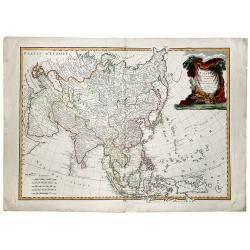
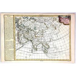
Carte d'Asie, divisée en ses principaux etats : assujettie aux observations astronomiques.
General uncommon map describing Asia with fine cartouche title at upper left.The map is of interest for the use of East Sea, the sea between Korea and Japan, here called ...
Date: Paris, 1787
Selling price: ????
Please login to see price!
Sold in 2012
Terrae Yemen Imperii Imami Principatus Kaukeban.
Important detailed copper engraved map of Yemen with details of South-West Arabia, prepared by C. Niebuhr and was published in "Atlas universel pour l'étude de la g...
Date: Paris, Nyon, 1787
Selling price: ????
Please login to see price!
Sold in 2013
Mare Rubrum Sinus Arabicus Ad Observationes Maximam Partem ab Auctore Annis MDCCLXII et MDCCLXIII.
Important detailed copper engraved map of Arabian Gulf with details of The Red Sea, The Gulf of Arabia and Yemen prepared by C. Niebuhr and was published in "Atlas u...
Date: Paris, Nyon, 1787
Selling price: ????
Please login to see price!
Sold in 2013
Sinus Persicus Maximam Partem ad Observationes Proprias a MDXXLXV.
Important detailed copper engraved map of the Persian Gulf with details of Persia and Arabia prepared by C. Niebuhr and was published in "Atlas universel pour l'ét...
Date: Paris, Nyon, 1787
Selling price: ????
Please login to see price!
Sold in 2013
Asia Veteribus Nota, L'Asie Ancienne
Intersting map of Asia with "Notes" to the left. Ribboned title cartouche. Engraved by Herault. Etienne André Philippe de Pretot (1708-1787) a royal censor, g...
Date: Paris, 1787
Selling price: ????
Please login to see price!
Sold in 2013
Turquie D'Asie a L'Exception de Enclaves Situees en Arabie.
Detailed, hand-colored, engraved map showing Turkey and parts of the Middle East and Near East. BONNE, RIGOBERT (1729-1795) Bonne was “Royal Hydrographer” and his pr...
Date: Paris, 1787
Selling price: ????
Please login to see price!
Sold in 2015
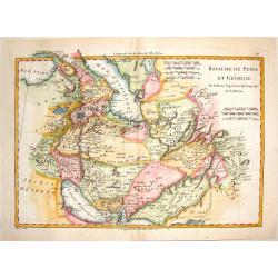
Royaume de Perse et Georgie.
Engraved map of Persia and Russian Georgia from "Atlas Encyclopedique". Spans the area between the Black Sea and the Persian Gulf. BONNE, RIGOBERT (1729-1795...
Date: Paris, 1787
Selling price: ????
Please login to see price!
Sold in 2015
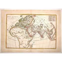
Orbis Antiquus.
A detailed map of the Eastern Hemisphere featuring Africa, Europe and Asia. Published in "Atlas Encylopedique" and engraved by Gaspar Andre. BONNE, RIGOBERT (...
Date: Paris, 1787
Selling price: ????
Please login to see price!
Sold in 2015
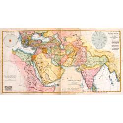
Imperia Antiqua.
Three maps that were joined together as planned and depict the eastern part of the Mediterranean, the Near East and the Indian subcontinent. They came from "Atlas En...
Date: Paris, 1787
Selling price: ????
Please login to see price!
Sold in 2014
Karte ploskaja ot' goroda Jakucka do Ochockago porta po rekam' Leny Aldana Maji Jodomy i Urakom' do Penzinskavo morja
A detailed map of the Urak River near Okhotsk, eastern Siberia from an unidentified source. The title of the map also in French " Carte dressée et levée en allant ...
Date: Paris, Nyon, Philippe de Prétot, 1787
Selling price: ????
Please login to see price!
Sold in 2014
Beschryvinge Van Den Oorsrong de Volkeren, Uit de Drie Sonen van Noah na den Sondvloed.
Striking hand-colored Dutch Bible map covering the region from the Mediterranean through to the Persian Gulf. the map depicts Abraham's route from Ur, Noah's arc, the wan...
Date: Amsterdam, 1787
Selling price: ????
Please login to see price!
Sold in 2015
Asia. 1787.
Scarce map of Asia published March 12 1787 for C. Stalker, Stationer's Court, Ludgate Street, London.The map is of interest for the use of Sea of Korea, the sea between K...
Date: London, ca. 1787
Selling price: ????
Please login to see price!
Sold in 2015
Asia Veteribus Nota. L'Asie Ancienne
A fine map of ancient Asia by Philippe de Pretot, published in Paris in 1787. The map features a decorative ribbon & drape title cartouche.Interestingly, there are sc...
Date: Paris, 1787
Selling price: ????
Please login to see price!
Sold in 2016
Asia veteribus nota.
A fine map of ancient Asia by Philippe de Pretot, published in Paris in 1787. The map features a decorative ribbon & drape title cartouche.Interestingly, there are sc...
Date: Paris, 1787
Selling price: ????
Please login to see price!
Sold in 2018
La Turchia in Europe....
La Turchia in Europe. A map of Turkey in Europe including Greece from the Gulf of Venice and Italy to Crete / Candia, to the Crimea and Black Sea.Engraved by Giovanni Pet...
Date: Rome, 1787
Selling price: ????
Please login to see price!
Sold in 2017
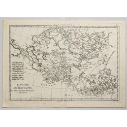
Tartarie Independante.
A fine, detailed, antique map of Tartary from the Black Sea to China and from Siberia to Tibet, by Bonne, published in the 1787 “Atlas Encyclopedique”.Rigobert Bonne ...
Date: Paris, 1787
Selling price: ????
Please login to see price!
Sold in 2021