Browse Listings in Asia > South East Asia
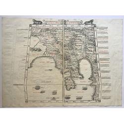
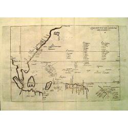
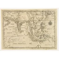
Undecima Asiae Tabula.
A rare, 500 year old woodblock map of SE Asia and China. Sylvanus' map of Southeast Asia, China, India, and adjoining regions, from Sylvanus' Claudii Ptholemaei Alexandri...
Date: Venice, 1511
Selling price: ????
Please login to see price!
Sold in 2017
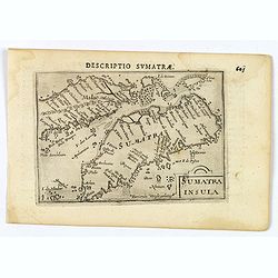
![Sumatra] Iava minore / Necumera/Locaz/Patera/Botegon/Mangama.](/uploads/cache/81948-250x250.jpg)
Sumatra] Iava minore / Necumera/Locaz/Patera/Botegon/Mangama.
Two maps on one page of the Isalario. 'Iava minore', the first printed separate map of Sumatra and several islands 'Necumera / Locaz / Patera / Botegon / Mangama. Locaz o...
Date: Venice, 1534
Selling price: ????
Please login to see price!
Sold in 2019
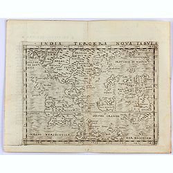
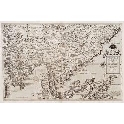
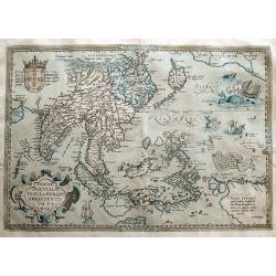
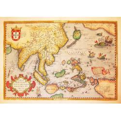
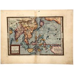
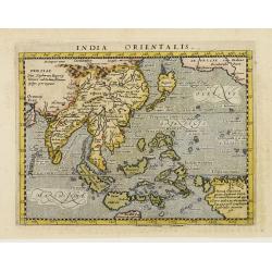
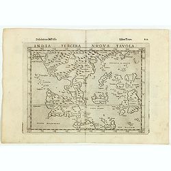
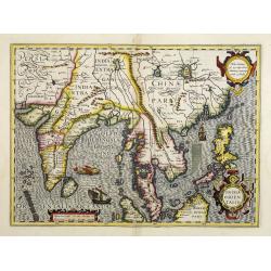
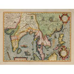
India Tercera Nova Tabula.
Gastaldi's map of South East Asia from Giacomo Gastaldi's Atlas of 1548 which has been called the most comprehensive atlas, produced between Martin Waldseemüller's Geogra...
Date: Venice, 1548
Selling price: ????
Please login to see price!
Sold in 2021
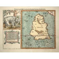
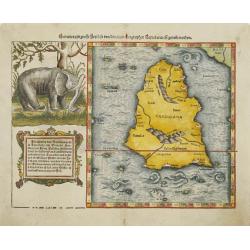
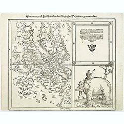
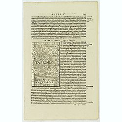
Sumatra ein grosse Insel so von den alten Geographen Taprobana genennt worden.
Sebastian Münster, 1489-1552, outstanding geographer of Basle. Edited Ptolemy's atlas Geographia Universalis, editions 1540,-42, -45, -51 and -52. Published his Cosmograp...
Date: Basel, c. 1550
Selling price: ????
Please login to see price!
Sold in 2008
![[Lot of 17 leaves with maps and views relating to India, Sri Lanka, China, Indonesia]](/uploads/cache/48280-250x250.jpg)
[Lot of 17 leaves with maps and views relating to India, Sri Lanka, China, Indonesia]
Seventeen text pages illustrated with wood block prints relating to India, Sri Lanka, China, Indonesia illustrated with animals : elephants, rhinoceros... From the 1552 L...
Date: Basel, 1552
Selling price: ????
Please login to see price!
Sold in 2022
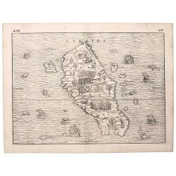
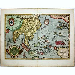
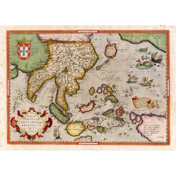
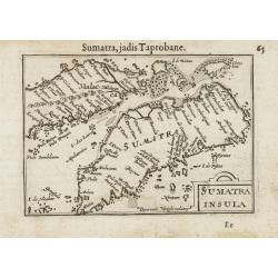
Sumatra.
A superb example of "the first separate map of any Southeast Asian island to be based on actual observation" (Suarez). It is moreover highly unusual for a map t...
Date: Venice, 1556
Selling price: ????
Please login to see price!
Sold in 2018
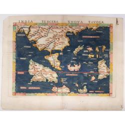
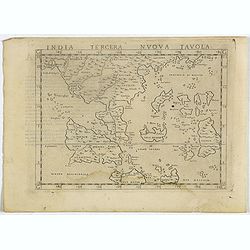
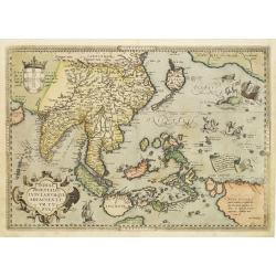
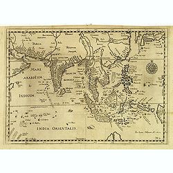
India Tercera Nuova Tavola
An early map of South East Asia after Gastaldi from "La Geographia: Descrittione dell' Asia", 3rd vol., p. 122; published by M. Sessa in Venezia, Italy, showin...
Date: Venice, 1561
Selling price: ????
Please login to see price!
Sold in 2021
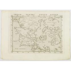
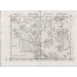
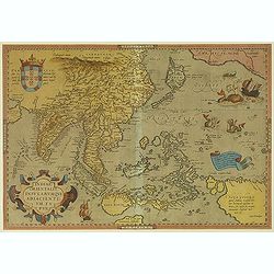
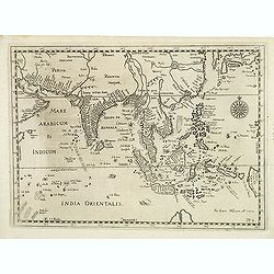
India Tercera Nuova Tavola.
Uncommon first edition of this early map of South East Asia.Girolamo Ruscelli's edition of Ptolemy's Geographia included newly engraved copperplates by Giulio and Livio S...
Date: Venice, 1561
Selling price: ????
Please login to see price!
Sold in 2008
India Tercera Nuova Tavola.
Uncommon first edition of this early map of South East Asia, showing the Bay of Bengal to southern China in the north, and down just below the Equator to the south. While...
Date: Venice, 1561
Selling price: ????
Please login to see price!
Sold in 2021
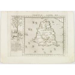
Tabula Asiae XII. . .
Uncommon first edition of one of the earliest maps of Sumatra.Girolamo Ruscelli's edition of Ptolemy's Geographia included newly engraved copperplates by Giulio and Livio...
Date: Venice, 1561
Selling price: ????
Please login to see price!
Sold in 2008
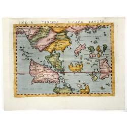
India Tercera Nuova Tavola.
Early edition of this modern map of South East Asia. Just to the west and south of Malacca one will notice ‘Camatra’ (Sumatra) and Java. Covers the region from the Gulf o...
Date: Venice, 1561
Selling price: ????
Please login to see price!
Sold in 2017
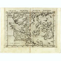
India Tercera Nuova Tavola.
Uncommon first edition of Ruscelli's map is one of the earliest modern maps of Southeast Asia. An enlarged version of Gastaldi's miniature map of 1548, the map is one of ...
Date: Venice / 1561
Selling price: ????
Please login to see price!
Sold in 2013
INDIA TERCERA NUOVA TAVOLA.
Ruscelli's map is one of the earliest modern maps of Southeast Asia. An enlarged version of Gastaldi's miniature map of 1548, the map is one of the earliest to introduce ...
Date: Venice, 1561
Selling price: ????
Please login to see price!
Sold in 2019
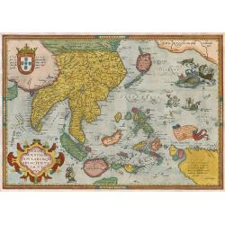
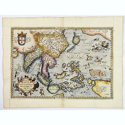
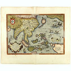
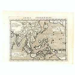
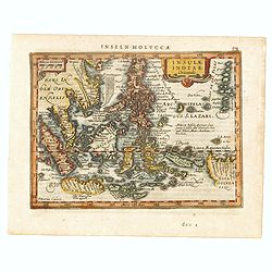
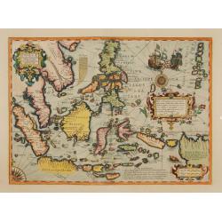
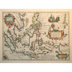
Indiae Orientalis, Insularumque Adiacientium Typus.
Finely contemporarily handcolored example of Ortelius' map of SE Asia, Japan, and the Philippines, etc. The map includes Beach and other information drawn from Marco Polo...
Date: Antwerpen, 1571
Selling price: ????
Please login to see price!
Sold in 2009
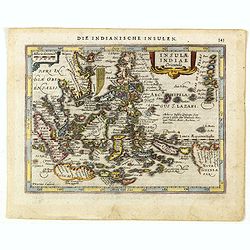
Indiae Orientalis, Insularumque Adiacientium Typus. . .
A finely hand colored example of Ortelius' highly decorative map of South East Asia, Japan, and the Philippines, etc from the Latin text edition of 1574. The map includes...
Date: Antwerp, 1574
Selling price: ????
Please login to see price!
Sold in 2018
Indiae Orientalis, insularumque adiacentium typus.
Fine example of Ortelius' map of SE Asia, Japan, and the Philippines, etc. The map includes Beach and other information drawn from Marco Polo, portion of the West Coast o...
Date: Antwerp, 1575
Selling price: ????
Please login to see price!
Sold in 2011
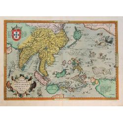
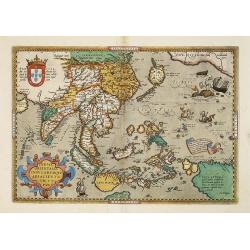
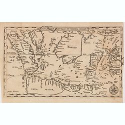
Tertiae Partis Asiae..
Map of India, Malaysia, China's south coast, Philippines, northern part of Sumatra, Borneo. From the extremely rare first edition.. Engraved by Joannes and Lucas van Deut...
Date: Antwerp 1578
Selling price: ????
Please login to see price!
Sold
Sumatra ein grosse insel..
Map of island of Taprobana, which was variously thought to be Ceylon or Sumatra. This map depicts Ceylon with the typical misconceptions of Ptolemy showing a small part o...
Date: Basle, 1578
Selling price: ????
Please login to see price!
Sold in 2009
Indiae Orientalis Insularumque Adiacientium Typus.
Famous milestone map of South-East Asia, China, Japan, Indonesia, and the Philippines. The map also includes parts of the West Coast of North America, including several m...
Date: Antwerp, 1579
Selling price: ????
Please login to see price!
Sold in 2012
Indiae Orientalis, Insularumque Adiacientium Typus..
Finely handcolored example of Ortelius' map of SE Asia, Japan, and the Philippines, etc. The map includes Beach and other information drawn from Marco Polo.The map also i...
Date: Antwerp 1580
Selling price: ????
Please login to see price!
Sold
Indiae Orientalis, Insularumque Adiacientium Typus. . .
Finely handcolored example of Ortelius' map of SE Asia, Japan, and the Philippines, etc. The map includes Beach and other information drawn from Marco Polo.The map also i...
Date: Antwerp, 1580
Selling price: ????
Please login to see price!
Sold in 2012
Sumatra ein grosse Insel..
One of the most interesting fruits of the revamping of the Münster Cosmographia in 1588 was this map of the southern Malay Peninsula and Sumatra, one of the earliest to f...
Date: Basle, 1580
Selling price: ????
Please login to see price!
Sold
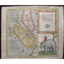
Sumatra Ein Grosse Insel / So Von Den alten Geographen Taprobana
An interesting map of Sumatra and the southern part of Malaysia. Singapore is identified at the tip of Malay peninsula as Cingafufa. Large textual cartouche which quotes ...
Date: Basle, 1580
Selling price: ????
Please login to see price!
Sold in 2011
Indiae Orientalis Insularumque Adiacentium Typus.
Finely originally hand colored example of Ortelius' important and highly decorative map of Southeast Asia. The title is set in a decorative strapwork cartouche, coat of a...
Date: Antwerp, 1584
Selling price: ????
Please login to see price!
Sold in 2012
Indiae Orientalis, Insularumque Adiacentium Typus
Map of Indonesia. From a French text edition of this illustrated treatise of geography, which is considered as the first modern pocket-atlas.Map engraved by Philip Galle....
Date: Antwerp, 1585
Selling price: ????
Please login to see price!
Sold in 2017
Indiae Orientalis, Insularumque Adiacientium Typus. . .
Striking handcolored example of Ortelius' map of SE Asia, Japan, and the Philippines, from the rare French text edition of 1587. The map includes Beach and other informat...
Date: Antwerp, 1587
Selling price: ????
Please login to see price!
Sold in 2016
Indiae Orientalis, Insularumque Adiacientium Typus. . .
Finely hand colored example of Ortelius' map of SE Asia, Japan, and the Philippines, etc from the rare French text edition of 1587. The map includes Beach and other infor...
Date: Antwerp, 1587
Selling price: ????
Please login to see price!
Sold in 2018
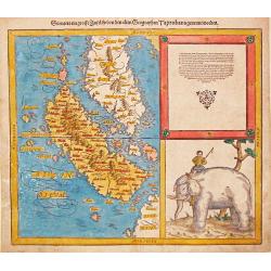
Sumatra ein Grosse Insel so von den Alten Geographen Taprobana Genennet Worden.
Early, desirable map of the island of Sumatra and the southern part of Malaysia. It is one of the earliest maps to focus on this region. Shown near today's Singapore on t...
Date: Basle, S.H. Petrie, 1588
Selling price: ????
Please login to see price!
Sold in 2014
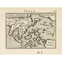
India Orient.
Miniature map of the Far East with Indonesia, Japan, Pacific and New Guinea. From the second series of miniature atlas of Ortelius' Epitome. A new series of pocket-size a...
Date: Antwerp 1589
Selling price: ????
Please login to see price!
Sold
Sumatra Insula - Taproba.
On recto a wood block printed map of Sumatra within text bearing the name "Taprobana". The island is filled with many images like an elephant and a tiger, as we...
Date: Basle, 1550-1590
Selling price: ????
Please login to see price!
Sold in 2013
![[Java Maior ]](/uploads/cache/32577-250x250.jpg)
[Java Maior ]
On recto a wood block printed map of Java (125x76mm.) with a short description of the island, underneath description of Madagascar , Zanzibar and "Duabus Insulis&quo...
Date: Basle, 1550-1590
Selling price: ????
Please login to see price!
Sold in 2013
![India extra Gangem, quae Europeis propinquior est. [India]](/uploads/cache/32585-250x250.jpg)
India extra Gangem, quae Europeis propinquior est. [India]
On recto an wood block printed Ptolemaic map of South East Asia, India and China (122x153mm.)From a German text edition of his Geographia , that great compendium of Renai...
Date: Basle, 1550-1590
Selling price: ????
Please login to see price!
Sold in 2013
INDIA ORIENTALIS. Cuius nobilior pars sunt duo-ista quasi ingentia totius Asiae promontoria in Oceanum versus Meridiem . . .
Matthäus Quad's uncommon map depicts most of the Asian continent stretching northward to encompass Japan and eastward to show the coast of North America and New Guinea. J...
Date: Cologne, ca. 1592
Selling price: ????
Please login to see price!
Sold in 2022
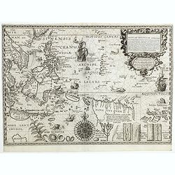
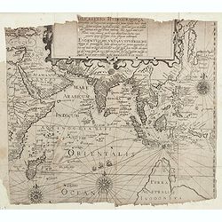
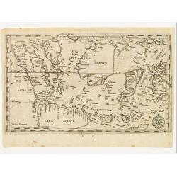
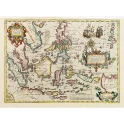
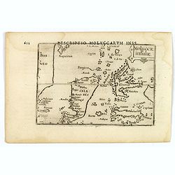
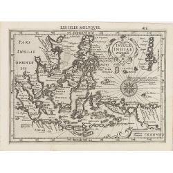
Insulae Moluccae celeberrimæ sunt ob Maximam aromatum copiam quam per totum terrarum orbem mittunt...
FIRST EDITION, engraved by Johannes à Doeticum c.1594. Very rare key map showing Southeast Asia with the Sunda Islands, the Moluccas, and much of the mainland coast well-...
Date: Amsterdam,1592-1594
Selling price: ????
Please login to see price!
Sold in 2018
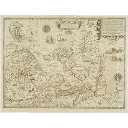
Exacta & accurata.. regionibus China, Cauchinchina, Camboja..
...the Far East and the Malay Archipelago are represented in such detail as was known only to the Portuguese at that time and had never before shown on a printed map. (S...
Date: Amsterdam 1595
Selling price: ????
Please login to see price!
Sold

Malache incole sermone et moribus quam reliqui Indi...Insulanus e Java gens dure cervicis.
In this well engraved copperplate engraving you see men and women of Malacca and Java, standing on a clifftop, with their city sprawled beneath them. Linschoten was a Dut...
Date: Amsterdam, after 1596
Selling price: ????
Please login to see price!
Sold in 2016
India Orientalis.
Attractive strong impression showing all island groups, including the Philippines and Japan.Also shows the West Coast of North America with the place name of Quivira.The ...
Date: Cologne 1597
Selling price: ????
Please login to see price!
Sold
India Orientalis.
Attractive strong impression showing all island groups, including the Philippines and Japan.Also shows the West Coast of North America with the place name of Quivira.The ...
Date: Cologne, 1597
Selling price: ????
Please login to see price!
Sold in 2017
India Tercera Nuova Tavola.
Fine 1598 edition of this early map of South East Asia. Just to the west and south of Malacca one will notice ‘Camatra’ (Sumatra) and Java. China with Canton in the upper...
Date: Venice, 1598
Selling price: ????
Please login to see price!
Sold in 2016
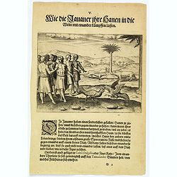
How the Javanese bet on cock-fighting.
The people of Java rear cocks for fighting and put bets on them for high sums of money. The fiercest and strongest birds are taken to an open space where pairs are chosen...
Date: Frankfurt, 1598
Selling price: ????
Please login to see price!
Sold in 2020
Descriptio Hydrographica accommodata ad Battavorum navagatio
The German writer Levinas Hulsius compiled an extensive collection of accounts of explorers' voyages, published ultimately in twenty-six parts. This handsome map sets out...
Date: Nuremberg 1598
Selling price: ????
Please login to see price!
Sold in 2019
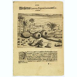
Illustrations of Lancuas, Fagaras, Lacca and Cuci fructa.
Common in Bali, Java and Sunda is a plant known as the great Galanga or Galigam. The natives, however, call it Lancuas. The fagaras, particularly found in Sunda, looks li...
Date: Frankfurt, 1598
Selling price: ????
Please login to see price!
Sold in 2026
Exacta & accurata.. regionibus China, Cauchinchina, Camboja..
...the Far East and the Malay Archipelago are represented in such detail as was known only to the Portuguese at that time and had never before shown on a printed map. (S...
Date: Amsterdam, 1598
Selling price: ????
Please login to see price!
Sold in 2017
India Orientalis.
Matthäus Quad's uncommon map depicts most of the Asian continent stretching northward to encompass Japan and eastward to show the coast of North America and New Guinea. J...
Date: Cologne 1600
Selling price: ????
Please login to see price!
Sold
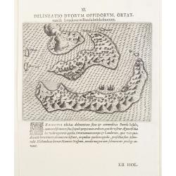
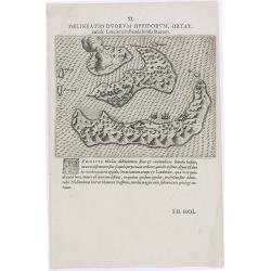
XI. Delineatio Duorum Oppidorum, Ortattani & Londorae in Banda Insula sitorum.
Earliest map of Banda islands. Copper engraving with letter press.
Date: Frankfurt 1600
Selling price: ????
Please login to see price!
Sold
Insulae Indiae Orientalis.
One of the most decorative maps of the Indonesian Archipelago, including the Philippines, Malaya and further India. Signed in the plate bottom left, P. Kaerius Calavit.Re...
Date: Amsterdam, c.1600
Selling price: ????
Please login to see price!
Sold in 2016
Insulae Indiae Orientalis.
One of the most decorative maps of the Indonesian Archipelago, including the Philippines, Malaya and further India. Signed in the plate bottom left, P. Kaerius Calavit.
Date: Amsterdam, c.1600
Selling price: ????
Please login to see price!
Sold in 2016
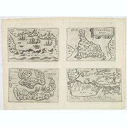
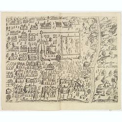
Amboinum Insula / Insulae Baly / Banda Insula / Java mayor.
Four maps on one sheet, extremely rare maps of Ambon, Banda, Bali and Java, included in Johannes Metelellus, Insularium Orbis Aliquot insularum tabulis Aeneis delineation...
Date: Cologne, 1601
Selling price: ????
Please login to see price!
Sold in 2019
Indiae Orientalis, Insularumque Adiacientium Typus.
Finely originally hand colored example of Ortelius' map of SE Asia, Japan, and the Philippines, etc. The map includes Beach and other information drawn from Marco Polo.Th...
Date: Antwerp, 1601
Selling price: ????
Please login to see price!
Sold in 2010
Descripcion De Las Indias Del Poniente 14.
Plate 14 from Herrera’s Descripción de las Indias Occidentales.The work is based on the manuscript charts of Juan Lopez de Velasco dating from approximately 157...
Date: Madrid, 1601
Selling price: ????
Please login to see price!
Sold in 2012
No title: South East Asia.
Very rare map of South East Asia, also including India, China, Japan and the northern tip of Australia , published by Hulsius.The German writer Levinus Hulsius compiled a...
Date: Nuremberg, 1602
Selling price: ????
Please login to see price!
Sold in 2012
No title: South East Asia.
Very rare map of South East Asia, also including India, China, Japan and the northern tip of Australia , published by Hulsius.The German writer Levinus Hulsius compiled a...
Date: Nuremberg, 1602
Selling price: ????
Please login to see price!
Sold in 2011
![[ South East Asia. ]](/uploads/cache/35256-250x250.jpg)
[ South East Asia. ]
Very rare map of South East Asia, also including India, China, Japan and the northern tip of Australia , published by Hulsius.The German writer Levinus Hulsius compiled a...
Date: Nuremberg, 1602
Selling price: ????
Please login to see price!
Sold in 2014
Insulae Indiae Orientalis et Molucae.
Very rare map of South East Asia, depicting Sumatra, Java, Borneo, Sulawesi, Moluccas, Bali, southern tip of Malaysia, mentioning "Siucapura" (Singapore), publi...
Date: Nuremberg, 1602
Selling price: ????
Please login to see price!
Sold in 2014
No title: South East Asia.
Very rare map of South East Asia, also including India, China, Japan and the northern tip of Australia , published by Hulsius.The German writer Levinus Hulsius compiled a...
Date: Nuremberg 1602
Selling price: ????
Please login to see price!
Sold
Indiae Orientalis Insularemque.
Covering all of South East, China, Japan (Kyushu and Honshu shown as one peculiar circular-shaped Island) and the West Coast of North America. The Northern coasts of New ...
Date: Antwerp 1602
Selling price: ????
Please login to see price!
Sold
Insulae Indiae Orientalis et Molucae.
Very rare map of South East Asia, depicting Sumatra, Java, Borneo, Sulawesi, Moluccas, Bali, southern tip of Malaysia, mentioning Siucapura, published by Hulsius.The Germ...
Date: Nuremberg 1602
Selling price: ????
Please login to see price!
Sold
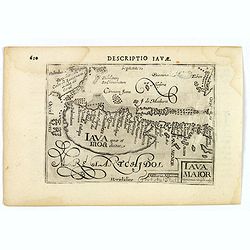
Iava Maior.
This map is one of the earliest obtainable maps of Java, pre-dating the establishment of Batavia. Interestingly, nothing is shown (or apparently known) along the southern...
Date: Amsterdam, 1606
Selling price: ????
Please login to see price!
Sold in 2021
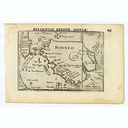
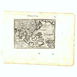
Descriptio Borneo Insula.
A miniature map of the Indonesian island of Borneo. Title is in bold capitals above the map. North is orientated to the left. The Equator runs through the southern part o...
Date: Amsterdam, 1606
Selling price: ????
Please login to see price!
Sold in 2019
Insulae Indiae Orientalis Praecipuae, In quibus Moluccae celeberrimae sunt.
Two beautiful new maps of Southeast Asia were created by the Dutch mapmaker Jodocus Hondius for an enlarged issue of the Mercator Atlas of 1606. One covered the Indian Oc...
Date: Amsterdam 1606
Selling price: ????
Please login to see price!
Sold
India Orientalis.
Published in Hondius' editions of the Mercator Atlas from 1606 onwards, showing the Indian subcontinent, the Malay Peninsula, Siam and Cambodia, China and the Philippines...
Date: Amsterdam, 1606
Selling price: ????
Please login to see price!
Sold in 2015
Moluccae Insulae.
An attractive miniature map of the Molucca Islands, formerly known as the 'Spice Islands', in Indonesia, published by Petrus Bertius, in Amsterdam at the beginning of the...
Date: Amsterdam, 1606
Selling price: ????
Please login to see price!
Sold in 2019
Insulae Indiae Orientalis Praecipuae, In quibus Moluccae celeberrimae sunt.
Two beautiful new maps of Southeast Asia were created by the Dutch mapmaker Jodocus Hondius for an enlarged issue of the Mercator Atlas of 1606. One covered the Indian Oc...
Date: Amsterdam 1606
Selling price: ????
Please login to see price!
Sold
India Orientalis.
Published in Hondius' editions of the Mercator Atlas from 1606 onwards, showing the Indian subcontinent, the Malay Peninsula, Siam and Cambodia, China and the Philippines...
Date: Amsterdam, 1606
Selling price: ????
Please login to see price!
Sold in 2010
Sumatra Insula.
This lovely miniature map shows the S.E. Asian Islands of Sumatra and (part) Malaysia, published by Petrus Bertius, in Amsterdam at the beginning of the seventeenth centu...
Date: Amsterdam, 1606
Selling price: ????
Please login to see price!
Sold in 2020
Insulae indiae orientalis..
This impressive map reflects the increasing Dutch interest in South East Asia in the wake of the establishment of the Dutch East India Company. It is one of two Asian map...
Date: Amsterdam, 1606
Selling price: ????
Please login to see price!
Sold in 2009
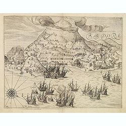
TIDORE.
View of Dutch vessels stationed in bay of Tidore. From Theodor and Johann Theodor de Bry's eighth volume compilation of voyages to the east, the so-called "Little Vo...
Date: Frankfurt, 1607
Selling price: ????
Please login to see price!
Sold in 2013
Delineatio Regiae Civitatis Candy. (Plan of the city in Ceylon.)
View of Dutch vessels stationed in bay of Tidore. From Theodor and Johann Theodor de Bry's eighth volume compilation of voyages to the east, the so-called "Little Vo...
Date: Frankfurt, 1607
Selling price: ????
Please login to see price!
Sold in 2013
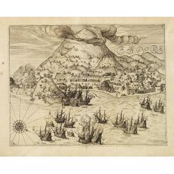
TIDORE.
View of Dutch vessels stationed in bay of Tidore. From Theodor & Johann Theodor de Bry's eighth volume compilation of voyages to the east, the so-called "Little ...
Date: Frankfurt 1607
Selling price: ????
Please login to see price!
Sold in 2008
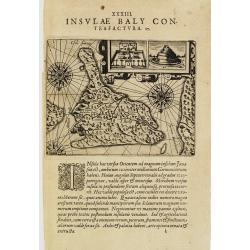
I.Baly.
Map of Bali, oriented to the south. Decorated with ships and three compass roses. With two insets representing buildings.From Theodor & Johann Theodor de Bry's eighth...
Date: Frankfurt 1607
Selling price: ????
Please login to see price!
Sold
Insulae Indiae Orientalis.
Charming map of the East Indies, including the Philippines, and the Malay Peninsula, from the first French-text edition of Jodocus Hondius' Atlas Minor.Covering the coast...
Date: Amsterdam, 1608
Selling price: ????
Please login to see price!
Sold in 2017
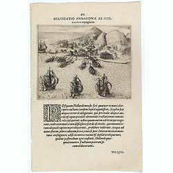
Delineatio Annabonae ab Holandis Expugnatae. (The Dutch attack on the Portuguese at Ambon Island)
The Dutch attack on the Portuguese at Ambon Island.Theodore de Bry, a German engraver and book dealer, began a compilation of early voyages in 1590 and had published six ...
Date: Frankfurt, 1609
Selling price: ????
Please login to see price!
Sold in 2017
![[Creatures of Java].](/uploads/cache/37950-250x250.jpg)
[Creatures of Java].
Two text engravings from "Premier livre de l'histoire de la navigation aux Indes Orientales, par les hollandois, et des choses a eux advenues . . . ", being the...
Date: Amsterdam, Cornille Nicolas, 1609
Selling price: ????
Please login to see price!
Sold in 2017
![[Java].](/uploads/cache/37965-250x250.jpg)
[Java].
Wood block engraved coastal profiles set in text from "Premier livre de l'histoire de la navigation aux Indes Orientales, par les hollandois, et des choses a eux adv...
Date: Amsterdam, Cornille Nicolas, 1609
Selling price: ????
Please login to see price!
Sold in 2025
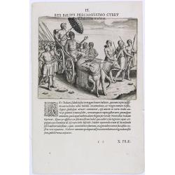
Rex Balius Preciosissimo Curru.
How the people of Bali transport their King. According to deBry: there are many horses on the island of Bali but they are small and only the simple folk ride them. Those ...
Date: Frankfurt, 1609
Selling price: ????
Please login to see price!
Sold in 2023
![[How the genteel folk of Bali are transported]](/uploads/cache/37935-250x250.jpg)
[How the genteel folk of Bali are transported]
Text engraving with explanation how the royalty and high-ranking citizens of Bali are transported about on light decorative chairs, with a shelter above to protect them f...
Date: Amsterdam, Cornille Nicolas, 1609
Selling price: ????
Please login to see price!
Sold in 2025
Delineatio Duorum Oppidorum, Ortat.
Early map of the Banda Islands.Theodore de Bry, a German engraver and book dealer, began a compilation of early voyages in 1590 and had published six parts at the time of...
Date: Frankfurt, 1609
Selling price: ????
Please login to see price!
Sold in 2025
![Moluccae Insulae [Molucca].](/uploads/cache/13293-250x250.jpg)
Moluccae Insulae [Molucca].
A miniature map of Moluccas, centered on Celebes Islands. Title cartouche on the upper right corner.First published in 1598 in his Caert-Thresoor, the plates were execute...
Date: Amsterdam / Frankfurt, 1609
Selling price: ????
Please login to see price!
Sold in 2016
Sumatra.
A miniature map of Sumatra containing detailed geography and nomenclature around the entire island. The neighboring coast of the Malay Peninsula is shown, including Singa...
Date: Amsterdam / Frankfurt, 1609
Selling price: ????
Please login to see price!
Sold in 2014
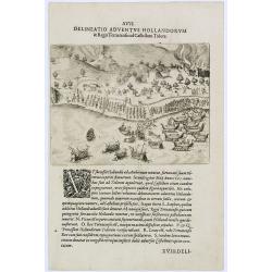
Delineatio Adventus Hollandorum. (Ternate Island)
Arrival of the Dutch at Ternate Island.Theodore de Bry, a German engraver and book dealer, began a compilation of early voyages in 1590 and had published six parts at the...
Date: Frankfurt, 1609
Selling price: ????
Please login to see price!
Sold in 2017
