Browse Listings in Asia > Malaysia / Singapore
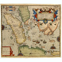
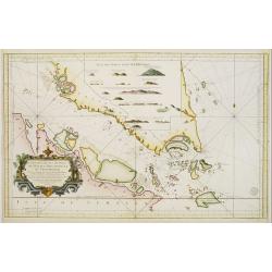
Nova tabula Insularum Javae, Sumatrae, Borneonis..
A most important foundation map, one of the first detailed European maps to focus on southern Malaysia and the region around present-day Singapore. The map was published ...
Date: Frankfurt, 1598
Selling price: ????
Please login to see price!
Sold in 2019
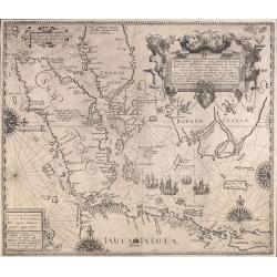
Nova tabula Insularum Javae, Sumatrae, Borneonis. . .
A most important foundation map, one of the first detailed European maps to focus on southern Malaysia and the region around present-day Singapore. The map was published ...
Date: Frankfurt, 1598
Selling price: ????
Please login to see price!
Sold in 2015
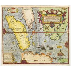
Nova tabula Insularum Javae, Sumatrae, Borneonis..
A most important foundation map, one of the first detailed European maps to focus on southern Malaysia and the region around present-day Singapore. The map was published ...
Date: Frankfurt 1598
Selling price: ????
Please login to see price!
Sold
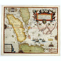
Nova tabula Insularum Javae, Sumatrae, Borneonis..
A most important foundation map, one of the first detailed European maps to focus on southern Malaysia and the region around present-day Singapore. The map was published ...
Date: Frankfurt, 1598
Selling price: ????
Please login to see price!
Sold in 2016
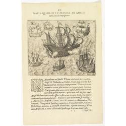
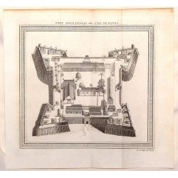
Navis Quaedam Lusitanica ab Anglis. . . (The English and Dutch attack a Portuguese ship )
A nice engraving of a battle between Dutch, English and Portuguese ships (137 x 167mm.) with a numbered key. According to the Latin explanation "On the 14th October,...
Date: Frankfurt, 1599
Selling price: ????
Please login to see price!
Sold in 2018
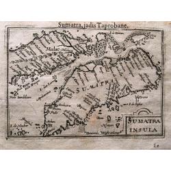
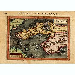
SUMATRA INSULA.
Superb miniature map of Sumatra and southern Malaysia (including Singapore). One of the earliest obtainable maps of the Strait of Malacca naming Singapore. With French te...
Date: Amsterdam, c. 1600
Selling price: ????
Please login to see price!
Sold in 2014
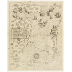
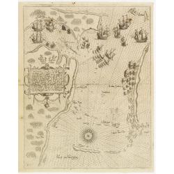
Contrafactur des Scharmutz els der Holander (Singapore)
An especially rare and beautiful map of Strait Singapore, with exquisite calligraphy and superb detail of Dutch and Portuguese ships in Strait Singapore. It shows only th...
Date: Frankfurt 1603
Selling price: ????
Please login to see price!
Sold
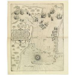
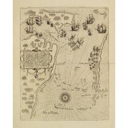
Contrafactur des Scharmutz els der Holander (Singapore)
An especially rare and beautiful map of Strait Singapore, with exquisite calligraphy and superb detail of Dutch and Portuguese ships in Strait Singapore. It shows only th...
Date: Frankfurt 1603
Selling price: ????
Please login to see price!
Sold in 2011
Contrafactur des Scharmutz els der Holander (Singapore)
An especially rare and beautiful map of Strait Singapore, with exquisite calligraphy and superb detail of Dutch and Portuguese ships in Strait Singapore. It shows only th...
Date: Frankfurt, 1603
Selling price: ????
Please login to see price!
Sold
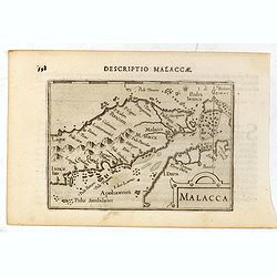
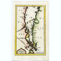
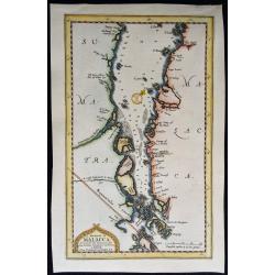
Malacca.
A rare miniature map of the area which is now the modern countries of Malaysia and Singapore. Singapore is 'Sincapura', and the Malaysian province of Solongor(Solongor), ...
Date: Amsterdam, Cornelis Claes, 1606
Selling price: ????
Please login to see price!
Sold in 2016
Contrafactur des Scharmutz els der Holander (Singapore)
An especially rare and beautiful map of Strait Singapore, with exquisite calligraphy and superb detail of Dutch and Portuguese ships in Strait Singapore. It shows only th...
Date: Frankfurt, 1607
Selling price: ????
Please login to see price!
Sold
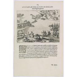
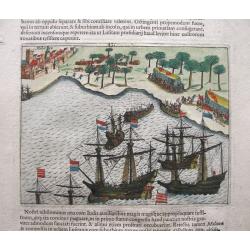
Lusitani ad Malaccam ab Hollan.
Dutchmen in Malacca Harbor repairing ships. Engraving by Theodore de Bry, a German engraver and book dealer, began a compilation of early voyages in 1590 and had publishe...
Date: Frankfurt, 1609
Selling price: ????
Please login to see price!
Sold in 2019
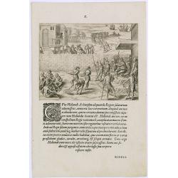
Cum Hollandi Achiensem aliquando Regem.
Scene during the second voyage of Jacob van Neck to the East Indies, from 1600-1604, during which he visited the islands of Ternate and Macao, and the city of Patane, in ...
Date: Frankfurt, 1609
Selling price: ????
Please login to see price!
Sold
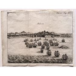
Siege of Malacca.
Siege of Malacca by admiral Cornelis Matelief. Malacca is in the background. The Dutch go ashore with boats and march on the city. Even though this map is much smaller th...
Date: Amsterdam, 1611
Selling price: ????
Please login to see price!
Sold in 2014
Malacca.
A miniature map of the area which is now the modern countries of Malaysia, Singapore and Thailand. West is at the top. Title cartouche on the upper right corner.First pub...
Date: Amsterdam, J.Hondius, 1616
Selling price: ????
Please login to see price!
Sold in 2014
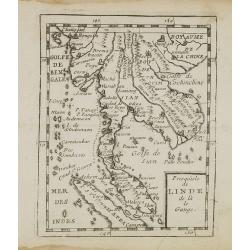
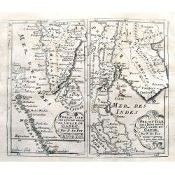
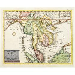
Presqu''isle de L'Inde de ça le Gange.
Uncommon miniature map of India from Pierre Duval's La Geographie Universeille dated 1676. Following his Cartes de geographie in 1657, Pierre Duval published this smaller...
Date: Paris, 1676
Selling price: ????
Please login to see price!
Sold in 2008
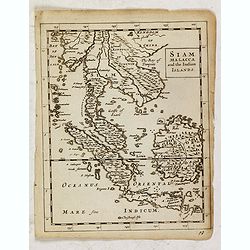
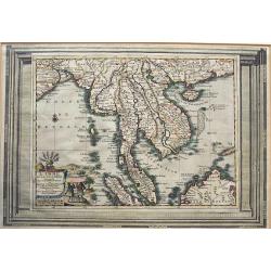
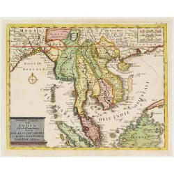
Siam, Malacca and the Indian Islands.
Uncommon map of Siam, Malacca and the Indian Islands, printed by A. Godbid and J. Playford, for R. Scott. Included in "New systeme of the mathematicks: containing . ...
Date: London, 1681
Selling price: ????
Please login to see price!
Sold in 2019

Habitans des Isles de la Sonde & Molusques (2 Prints)
Two fine engravings of the inhabitants of Indonesia. They are from "Geographie, Ancienne & Moderne."
Date: Paris, 1683
Selling price: ????
Please login to see price!
Sold in 2017
Die Statt Malacca in Indien.
Panoramic town-view of Malacca, published in Wagner, "Delineatio Provinciarum Pannoniae". Unsigned engraving. The engravings for Wagner's book were executed by ...
Date: Augsburg, Koppmayer, 1685
Selling price: ????
Please login to see price!
Sold in 2016
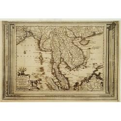
Penisola della India...
Giacomo Rossi's fine late 17th century map of southeast Asia, extending from the border of China in the north ("frontiere della China"), with the entire Malaysi...
Date: Rome, 1683-1688
Selling price: ????
Please login to see price!
Sold in 2015
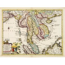
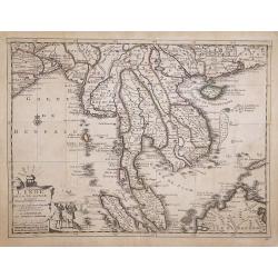
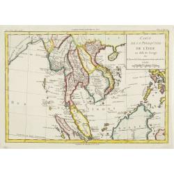
Penisola dell India di là dal Gange. . .
Giacomo Rossi's fine late 17th century map of Malaysia, Thailand, Cambodia and part of Sumatra. Issued in Il Mercurio geografico In lower right hand corner a large title ...
Date: Rome, 1683-1688
Selling price: ????
Please login to see price!
Sold in 2013
![Globe gore [Malysia, Thailand, Western China.]](/uploads/cache/31211-250x250.jpg)
Globe gore [Malysia, Thailand, Western China.]
A globe gore of modern day Thailand, Vietnam, Cambodia, Burma, Nepal, Malaysia, Singapore, northern part of Sumatra, Indian Ocean, and western China. Published in Coronel...
Date: Venice, 1696
Selling price: ????
Please login to see price!
Sold in 2011
Presqu'isle de l'Inde decale Golfe du Gange. & Presqu'isle de l'Inde dela le Golfe du Gange.
Two early maps on one sheet, one showing souther India, the Maledives and Sri Lanka. The other shows former Pegu and Siam, todays Myanmar, Thailand, Malaysia, Cambodia, L...
Date: Paris, ca. 1710
Selling price: ????
Please login to see price!
Sold in 2019
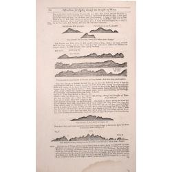
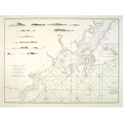
Two double sided pages No's 57 & 58 A Description of the West Coast of Sumatra & The West coast of Sumatra 59 & 60 The West coast of Sumatra & Instructions for Sailing through the Streights of Diron
Four woodblock chart’s on two double sided sheets by Samuel Thornton showing the approaching coast lines of Sumatra. Published in "The English Pilot, the Third Boo...
Date: London 1711
Selling price: ????
Please login to see price!
Sold in 2014
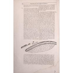
Two double sided pages No's 61 & 62 Directions for the Streights of Singapore. 63 & 64 Directions for the Old Streights of Singapore & Instructions for Sailing from Pulo Tingay to Siam.
Four woodblock chart’s on two double sided sheets by Samuel Thornton showing the approaching coast lines of Singapore & Thailand.Published in "The English Pilo...
Date: London, 1711
Selling price: ????
Please login to see price!
Sold in 2014
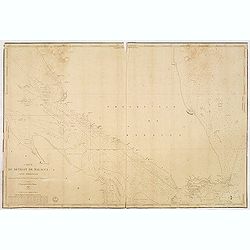
Le Detroit de Malacca. . .
Map of Malacca. The map details the Strait of Malacca from P. Pera and Tanjong Goeree to Lingen and Pulu Panjang. Malacca and Ihor (Johore), along with numerous other coa...
Date: Leiden, 1712
Selling price: ????
Please login to see price!
Sold in 2020
Le détroit de Malacca.
A map of the Strait of Malacca between the Malay Peninsula and the Indonesian island of Sumatra. The north is towards the top right corner. The map details the Strait of ...
Date: Leiden, 1712
Selling price: ????
Please login to see price!
Sold in 2019
L'Inde De La Le Gange Suivant les Nouvelles Observations...
Fantastic map of South East Asia with today's Malaysia, Thailand, Vietnam Bay of Bengal, Hainan, Straits of Malaca, and the Northern parts of Sumatra and Borneo. Singapor...
Date: Amsterdam, 1714
Selling price: ????
Please login to see price!
Sold in 2016
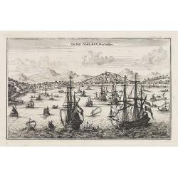
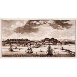
Malacca.
A fine print showing Dutch vessels offshore the city of Malacca. From the French reissue of the account of early Dutch voyages first published in 1608 by Commelin. The Fr...
Date: Amsterdam, 1725
Selling price: ????
Please login to see price!
Sold in 2016
De Stad Malacka.
"Decorative panoramic view of the town of Malacca with European vessels in the foreground. The old Church of St. Paul's on the hill in the fortified old town to the ...
Date: Amsterdam 1726
Selling price: ????
Please login to see price!
Sold
L'Inde de la le Gange, suivant les nouvelles observations?
Uncommon edition of this map of Malaysia, Thailand, Indo China and the Northern parts of the islands of Sumatra and Borneo. Singapore marked as Sincapour. With decorative...
Date: Amsterdam 1728
Selling price: ????
Please login to see price!
Sold
L'Inde de la le Gange, suivant les nouvelles observations?
Decorative map of Malaysia, Thailand, Indo China and the Northern parts of the islands of Sumatra and Borneo. Singapore marked as Sincapour.Although not renowned for the ...
Date: Amsterdam 1728
Selling price: ????
Please login to see price!
Sold
L'Inde de la le Gange, Suivant les Nouvelles Observations.
An attractive detailed map of Malaysia, Thailand, Indo-China, Sumatra, Borneo and Singapore, spelt as "Sincapour" on the map from the Covens and Mortier edition...
Date: Amsterdam, 1730
Selling price: ????
Please login to see price!
Sold in 2017
Carte des mers comprises entre le détroit de Banca et P°. Timon avec la partie orientale du détroit de Malacca.
Important French chart of the tip of Malaysia with Singapore.Latitude and longitude scales, compass rose and system of rhumb lines, soundings near coast and in bay areas....
Date: Paris, Jean-François Robustel, 1745
Selling price: ????
Please login to see price!
Sold in 2014
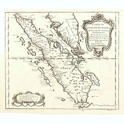
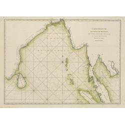
Carte de l'Isle de Sumatra. . .
Map of Sumatra, also showing the tip of the Malay Peninsula and the Straits of Singapore. An unusually detailed map of the area, showing many coastal features, shoals, ba...
Date: Paris, 1749
Selling price: ????
Please login to see price!
Sold in 2016
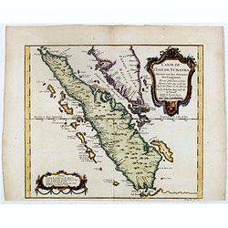
Carte de l'Isle de Sumatra. . .
Map of Sumatra, also showing the tip of the Malay Peninsula and the Straits of Singapore. An unusually detailed map of the area, showing many coastal features, shoals, ba...
Date: Paris, 1749
Selling price: ????
Please login to see price!
Sold
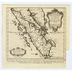
Carte de L'Isle de Sumatra Dressee sur les Journaux des Navigateurs . . .
Detailed map of Sumatra and Malacca, centered on Singapore and including the southern portion of the Malaysian peninsula. With "Detroit de Sincapour" and severa...
Date: Paris, ca. 1750
Selling price: ????
Please login to see price!
Sold in 2014
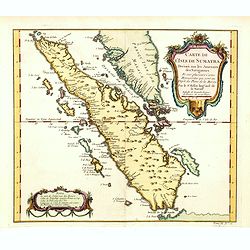
Carte de l'Isle de Sumatra. . . / Kaart van het Eiland Sumatra. . .
Map of Sumatra, also showing the tip of the Malay Peninsula and the Straits of Singapore. An unusually detailed map of the area, showing many coastal features, shoals, ba...
Date: The Hague, 1753
Selling price: ????
Please login to see price!
Sold in 2019
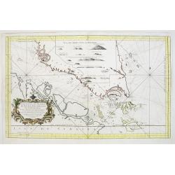
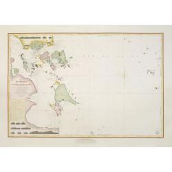
![Pas=Kaart van de Vaarweg van Straat BANCA [?] en SINCAPOERA ..](/uploads/cache/23815-250x250.jpg)
Pas=Kaart van de Vaarweg van Straat BANCA [?] en SINCAPOERA ..
A finely engraved and detailed chart of southern tip of Malacca, with Singapore.Very rare: only included in 6th volume (so-called secret atlas) of Van Keulen's. Latitude ...
Date: Amsterdam 1753
Selling price: ????
Please login to see price!
Sold
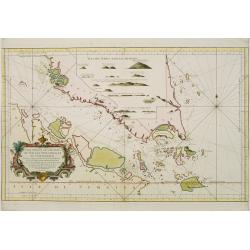
![Nieuwe Caart [..] van Banca langs [..] Malacca, Siam, Cambodia, Conchinchina](/uploads/cache/23814-250x250.jpg)
Nieuwe Caart [..] van Banca langs [..] Malacca, Siam, Cambodia, Conchinchina
A finely engraved and detailed chart of Malacca, with Singapore, Cambodia, Thailand and part of Borneo, Philippines, and many other islands in the South China Sea.Very ra...
Date: Amsterdam, 1753
Selling price: ????
Please login to see price!
Sold in 2008
Fort Hollandois de L'Isle de Banda.
Striking view of Fort Nassau Banda which is on the Maluku Islands in Indonesia. The fortification view is from "HISTOIRE GENERALE DES VOYAGES". Jacques Nicola...
Date: Paris, 1754
Selling price: ????
Please login to see price!
Sold in 2014
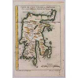
Carte de L'Isle Celebes ou Macassar.
A fine little copper engraved map of Celebes Island, Makassar.
Date: Paris, 1754
Selling price: ????
Please login to see price!
Sold in 2018
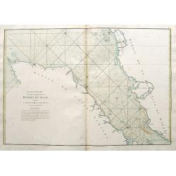
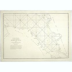
Carte Réduite duite des Detroits de Malaca, Sincapour, et du gouverneur
Attractive large chart showing Malay Peninsula from north of Selangor to Pulor Tioman with adjacent coast of Sumatra and the islands southwards to Lingga. Latitude and lo...
Date: Paris 1755
Selling price: ????
Please login to see price!
Sold
Carte Réduite des Detroits de Malaca, Sincapour, et du gouverneur
Attractive large chart showing Malay Peninsula from north of Selangor to Pulor Tioman with adjacent coast of Sumatra and the islands southwards to Lingga. Latitude and lo...
Date: Paris, 1755
Selling price: ????
Please login to see price!
Sold
Carte Réduite des Detroits de Malaca, Sincapour..
Attractive large showing Malay Peninsula from north of Selangor to Pulor Tioman with adjacent coast of Sumatra and the islands southwards to Lingga. Latitude and longitu...
Date: Paris 1755
Selling price: ????
Please login to see price!
Sold
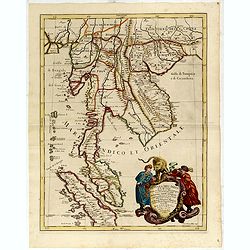
Nuova carte dell' India di là del Fiume Ganges overo di Malacca Siam Cambodia Chiampa KoChinchina Laos Pegu ava&c.
Fine map of Malay Peninsular, with present-day Thailand, taken from Storia moderna di tutti I popoli del mondo , edited by Thomas Salmon. A Italian edition of this famous...
Date: Venice, 1740-1756
Selling price: ????
Please login to see price!
Sold in 2013
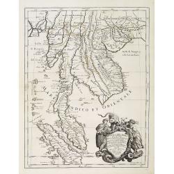
Nuova carte dell' India di là del Fiume Ganges overo di Malacca Siam Cambodia Chiampa KoChinchina Laos Pegu ava&c.
Fine map of Malay Peninsular, with present-day Thailand, taken from Storia moderna di tutti I popoli del mondo , edited by Thomas Salmon. A Italian edition of this famous...
Date: Venice 1740-1756
Selling price: ????
Please login to see price!
Sold
Nouvelle carte des mers comprises entre le détroit de Banca et P°. Timon avec la partie orientale du détroit de Malacca.
Important French of the tip of Malaysia with Singapore.Latitude and longitude scales, compass rose and system of rhumb lines, soundings near coast and in bay areas.Engra...
Date: Paris, Jean-François Robustel, 1774
Selling price: ????
Please login to see price!
Sold in 2013
Carte de la Presque' Isle de l' Inde.
A map of Indochina, Thailand, Malaysia, the Philippines and the island of Hainan. Published by Louis Brion de la Tour (1756-1823), and included in his Histoire Universel.
Date: Paris, 1774
Selling price: ????
Please login to see price!
Sold in 2015
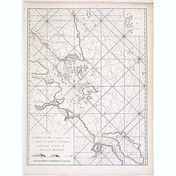
Carte réduite du Golfe du Bengale depuis l'Isle de Ceylan jusqu'au Golf du Siam?
French chart of Gulf of Bengal. Including the east coast of India with Sri Lanka and the Malay Peninsular till Malacca, Cambodia. Latitude and longitude scales, compass r...
Date: Paris, ca 1775
Selling price: ????
Please login to see price!
Sold
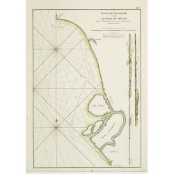
Carte Plate de la partie Septentrionale du Détroit de Malac depuis la Rade d'Achem jusqu'à Malac.
A large sea-chart of the strait of Malacca, with a part of Sumatra and Malaysia. Highly detailed with bays, depth soundings, hazards, islands, rivers, etc. A French sailo...
Date: Paris, 1775
Selling price: ????
Please login to see price!
Sold in 2018
Nouvelle Carte des Mers Comprises entre le Détroit de Banca et P. . . Timon, avec la partie Orientale du Détroit de Malac.
French of the East Coast of Sumatra, the eastern portion of the Strait of Malacca, and the coast of Malaysia, showing strait Banca and island of Pulo Timon. Singapore me...
Date: Paris, ca 1775
Selling price: ????
Please login to see price!
Sold in 2011
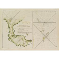
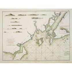
Plan du Port de Rio situé au détroit de Malaca en l'Isle de Bintam. / Plan du Détroit du Gouverneur.
Two French charts on one sheet, to the left a chart of the bay around Batam center on the little island Batam, opposite Singapore. With a lettered key. The chart to the r...
Date: Paris, ca 1775
Selling price: ????
Please login to see price!
Sold in 2012
Carte Plate de la partie Septentrionale du Detroit de Malac, depuis la Rade d\'Achem Jusqu\'a Malac.
French of the Malacca Strait north of Malacca, on page (39) from Le Neptune Orientale, 2nd edition. Latitude and longitude scales, compass rose and system of rhumb lines...
Date: Paris, Brest, chez Demonville, 1775
Selling price: ????
Please login to see price!
Sold in 2014
Plan de Salangor et de la Cote de Malaye depuis la Pointe de Caran jusqu'au Mont Parcelar.
Important early French of Salangor and Coast of Malaye, with two profile views over the coast near Selangor. From the second edition.Latitude and longitude scales, compa...
Date: Paris, Brest, chez Demonville, 1775
Selling price: ????
Please login to see price!
Sold in 2013
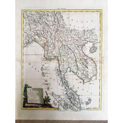
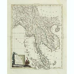
Regni D'Aracan Del Pegu Di Siam Di Camboge E Di Laos.
An elegant map with a decorative cartouche.
Date: Venice, 1785
Selling price: ????
Please login to see price!
Sold in 2019
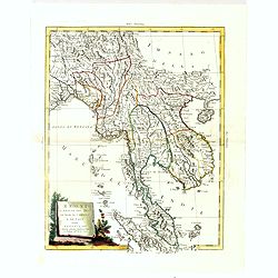
Regni D'Aracan Del Pegu Di Siam Di Camboge E Di Laos . . . 1785
Striking map of the region from the Gulf of Bengal to Hainan, centered on the Malay Peninsula, Straits of Malacca and most of Sumatra.The map was issued in Zatta's "...
Date: Venise, 1785
Selling price: ????
Please login to see price!
Sold in 2011
Regni D'Aracan Del Pegu Di Siam Di Camboge E Di Laos . . . 1785.
Striking regional map, extending from the Philippines and Moluccas to India and the Maldives, and north to Tibet. Decorative scroll title cartouche.
Date: Venise, 1785
Selling price: ????
Please login to see price!
Sold in 2017
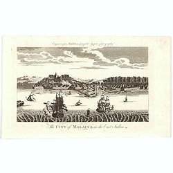
The City of Malacca in the East Indies.
A late eighteenth century copperplate view of the Malaysian city of Malacca - the oldest city on the straights of Malacca. The city entrance from the Malacca River is cle...
Date: London, 1790
Selling price: ????
Please login to see price!
Sold in 2020
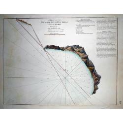
A Plan of the Bay on the South West Side of Pulo Auore...
VERY RARE from "The country East-India Pilot" published in 1799 by Laurie & Whittle. Important copper engraved map of the Bay on this island near Singapor...
Date: London, 1799
Selling price: ????
Please login to see price!
Sold in 2011
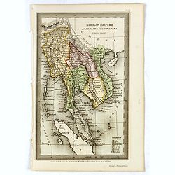
Birman Empire with Anam, Siam & Cochin China.
Charming map of Thailand, Cambodia, Malaysian peninsular with Singapore named. Very detailed with a numbered key (1-10) to States and Territories. Published for the propr...
Date: London 1832
Selling price: ????
Please login to see price!
Sold in 2016
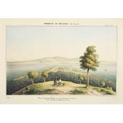
Presqu'ile de Malacca.. - Vue de George Town, prise de la Moutagne des siguaux. Ile du Prince de Galles (Pulo-Pinang).
Lithography representing a view of George Town on Pinang island. Plate N° 10.From Souvenirs d'un voyage dans l'Inde, exécuté de 1834 à 1839, by A. Delessert.Adolphe D...
Date: Paris, 1843
Selling price: ????
Please login to see price!
Sold in 2008
Carte des Détroits Singapore, Durain..
Large scale map of Singapore, the Sunda Islands with Linga and part of the east coast of Sumatra. Prepared after maps by d'Horsburgh and other Dutch charts (M.M.Dittlof T...
Date: Paris 1846
Selling price: ????
Please login to see price!
Sold
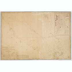
Carte du détroit de Malacca. Partie Septentrionale comprenant depuis Poulo Penang jusqu'au Mont Parcelar. . .
Detailed chart depicting the strait of Malacca and the north west coast of Malaysia, from the island Pulau Pinang to Pelabuhan Klang west of Kuala Lumpur.With inset chart...
Date: Paris, 1843 updated to 1853
Selling price: ????
Please login to see price!
Sold in 2013
Carte du détroit de Malacca. Partie Méridionale comprenant depuis le Mont Parcelar jusqu'à Singapoure.
Detailed chart depicting the strait of Malacca and the southern tip of Malaysia, including the island Singapore.The chart was actually used and has some lead pencil annot...
Date: Paris, 1843 updated to 1853
Selling price: ????
Please login to see price!
Sold in 2013
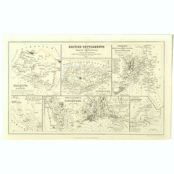
British settlements in the Malay peninsula and coast of Borneo . . .
Set of six little maps on one sheet, including a map of the Coast of Borneo, Singapore, Malacca, etc. Engraved by J. Bartholomew.
Date: London, A.Fullarton, c. 1860
Selling price: ????
Please login to see price!
Sold in 2019
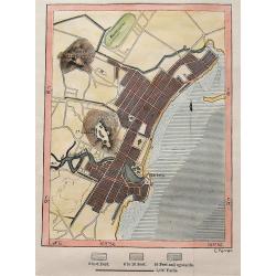
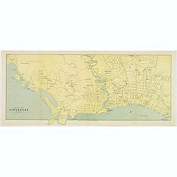
Singapore.
A simplified plan of Singapore, including streets and rivers. Names the Racecourse, the Palace of the Governor, Fort Canning, and the Battery. Indicates the depth of the ...
Date: London, ca. 1890
Selling price: ????
Please login to see price!
Sold in 2016
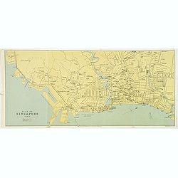
Plan of Singapore.
color lithographed Street Plan of Singapore. The map was drawn at the beginning of the twentieth century.Underneath the plan "Drawn and engraved for the Directory an...
Date: Edinburgh, 1908
Selling price: ????
Please login to see price!
Sold in 2018
Plan of Singapore.
A detailed plan of the city of Singapore in the early 1900s. Underneath the map "Drawn and Engraved for the Directory and Chronicle". Scale of 1/2 inch to a mil...
Date: Edinburg, ca 1908
Selling price: ????
Please login to see price!
Sold in 2012
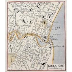
Singapore.
Despite its small size it shows the city in great detail, with many street names, buildings, and places, etc. Includes the Raffles Hotel, the railway station, exchange, p...
Date: London, ca. 1920
Selling price: ????
Please login to see price!
Sold in 2016
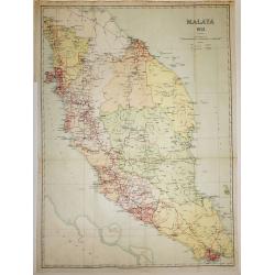
Malaya 1931
An interesting map of Malaysia with Singapore, dated 1931, and it’s Islands, showing main roads and railways. The States are defined by color.Published under the Direct...
Date: London, 1931
Selling price: ????
Please login to see price!
Sold in 2016
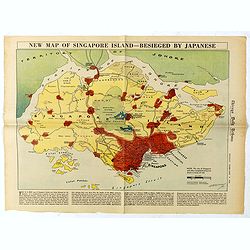
New Map of Singapore Island - Besieged by Japanese. Chicago Daily Tribune, Monday, February 9, 1942
color pictorial map designed by , single sheet from the Chicago Daily Tribune, "This is a new map of Singapore Island, now being besieged by the Japanese. North of t...
Date: Chicago, 1942
Selling price: ????
Please login to see price!
Sold in 2019
Traveller's guide to Singapore 1958 - The world in miniature.
Decorative travel guide with two folding maps, one colored map of South East Asia (250 x 325mm.) and another of Singapore (280 x 420mm.). Decorative wrapper and filled wi...
Date: Singaopore, 1958
Selling price: ????
Please login to see price!
Sold in 2017
