Browse Listings in Asia
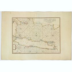
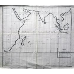
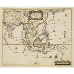
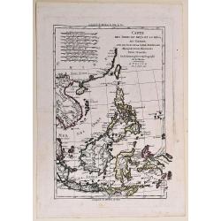
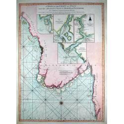
A Chart of the Isle of Java, with the Islands of Banca and Billiton. . .
An English edition, published by Robert Sayer in London, of the Island of Java, Banca, Billiton, and part of Sumatra and Borneo. With an iInset part of Lubeck Island. Lat...
Date: London, 1787
Selling price: ????
Please login to see price!
Sold in 2021
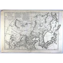
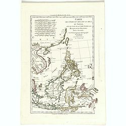
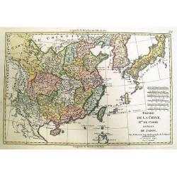
Tartarie Chinoise, Roy. De Coree et Isles du Japan.
A fine map of the Asian region including Japan, Korea, Manchuria and the Gobi Desert. Highly detailed. From Bonne's 'Atlas Supplement'.Rigobert Bonne (1727–1795) was a ...
Date: Paris, 1787
Selling price: ????
Please login to see price!
Sold in 2023
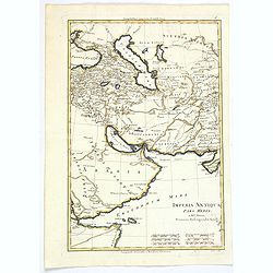
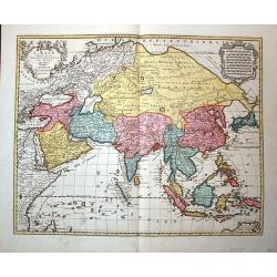
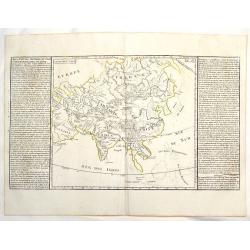
Imperia Antiqua. Pars Media.
A map of the Near East from Rigobert Bonne's "Atlas Encyclopedique." Rigobert Bonne (1727-1795) was one of the most important cartographers of the late 18th cen...
Date: Paris, 1787
Selling price: ????
Please login to see price!
Sold in 2021
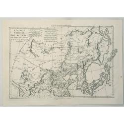
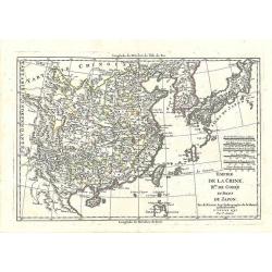
Tartarie Chinoise, Roy, Coree et Isles du Japon.
A detailed map of the region, including Japan, Korea, Manchuria and the Gobi Desert. Highly detailed. From Bonne's 'Atlas Supplement', published in 1787.Rigobert Bonne (1...
Date: Paris, 1787
Selling price: ????
Please login to see price!
Sold in 2023
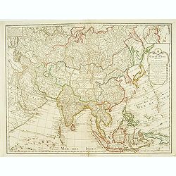
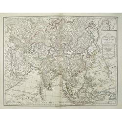
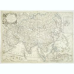
Carte d'Asie..
Detailed map of Asia with inset map of Siberia and the east coast of America.
Date: Paris, 1788
Selling price: ????
Please login to see price!
Sold
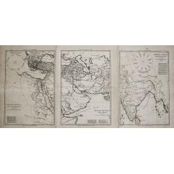
Imperia Antiqua. Pars Occidentalis/ Pars Media/ Pars Orientalis.
Rigobert Bonne (1727-1795), French cartographer. His maps are found in a.o. Atlas Moderne (1762), Raynal's Histoire Philos. du Commerce des Indes (1774) and Atlas Encyclo...
Date: Paris, 1787-1788
Selling price: ????
Please login to see price!
Sold
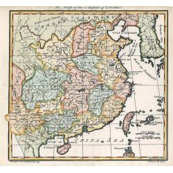
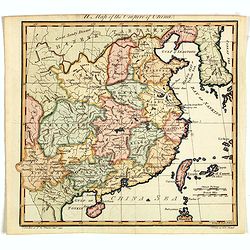
A Map of the Empire of China.
An attractive and uncommon map of China from Trusler's multi-volume work, "The Habitable World Described".
Date: London, 1788
Selling price: ????
Please login to see price!
Sold in 2018
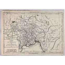
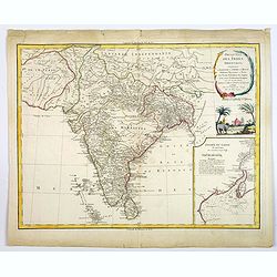
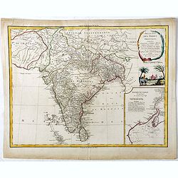
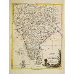
Neueste Karte von Hindostan, Bengalen etc. . .
Wall map of the Indian sub-continent after James Rennell, with large title cartouche of Britannia, native figures, a soldier and a merchant. Published by F. A. Schraembl ...
Date: Vienna, 1788
Selling price: ????
Please login to see price!
Sold
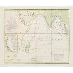
Carte des déclinaisons et inclinaisons de l\'aiguille aimantée...1775
Rare large sea-chart of the Indian Ocean, indicating the magnetic variations of the compass needle. The map shows the coasts of Africa, Madagascar, Arabia, India, South ...
Date: Paris, 1788
Selling price: ????
Please login to see price!
Sold in 2016
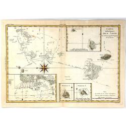
Carte des Isles des Amis
A finely engraved chart depicting the Friendly Islands, including the Kingdom of Tonga.The islands were discovered by Captain Cook, and his passage aboard the Resolution ...
Date: Paris, 1788
Selling price: ????
Please login to see price!
Sold in 2021
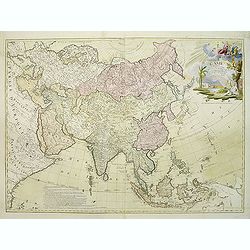
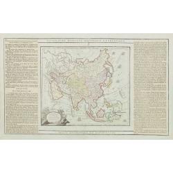
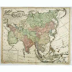
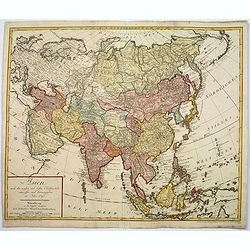
Asia.
A fine map of Asia. It covers the area from Italie to Australia.Rigobert Bonne (1727-1795) was one of the most important cartographers of the late 18th century. In 1773 h...
Date: Paris, 1788
Selling price: ????
Please login to see price!
Sold in 2020
A Map of the Empire of China.
An attractive and uncommon map of China from Trusler's multi-volume work, "The Habitable World Described". In his Description of China, Trusler relied on the wr...
Date: London, 1788
Selling price: ????
Please login to see price!
Sold in 2020
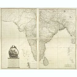
Neueste Karte von Hindostan, Bengalen etc. . .
Wall map of the Indian sub-continent after James Rennell, with large title cartouche of Britannia, native figures, a soldier and a merchant. Published by F. A. Schraembl...
Date: Vienna, 1788
Selling price: ????
Please login to see price!
Sold in 2019
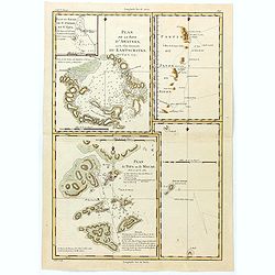
Plan de la Baye d'Awatska sur la Cote du Kamschatka
An interesting map of several countries along the east coast of Asia. In addition to Kamchatka, it includes Partie du Japon ou Nippon, Plan du Typa ou de Macao, Plan du H...
Date: Paris, 1788
Selling price: ????
Please login to see price!
Sold in 2023
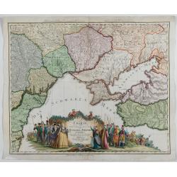
Charte von den oberhalb und seitwärts dem Schwarzen Meere gelegenen Russischen und Türkischen Ländern …
Very rare and detailed map of the black sea region, including parts of Ukraine, Turkey and Poland. In the lower part, a color key. Beautiful tittle cartouche with Empress...
Date: Berlin, 1788
Selling price: ????
Please login to see price!
Sold in 2023
L'Asie divisée en ses regions et etats et subdivisée en ses principales parties. . .
Interesting wall map of Asia, with a decorative title cartouche upper right corner, showing Adam and Eve. The map is of interest for the use of East Sea, the sea between ...
Date: Paris, 1789
Selling price: ????
Please login to see price!
Sold in 2020
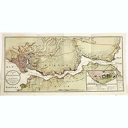
Plan de Constantinople et du Bosphore: pour servir de renseignement à la carte des limites des trois empires, ou théatre de la guerre présente, 1788.
Detailed map of the Bosporus, with inset map "Plan du Serrail", 7 x 16 cm. Scale: [Ca. 1:60 000]. Prepared by François Joseph Maire (Vienna, 1738 - c.1800). F....
Date: Vienna, 1788-1789
Selling price: ????
Please login to see price!
Sold in 2014
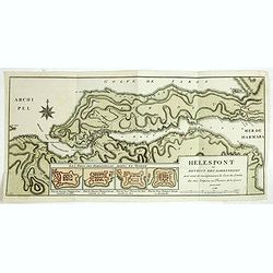
Hellespont ou Detroit des Dardanelles pour servir de renseignement a la Carte des Limites des trois Empires ou Théatre de la Guerre presente 1788.
Detailed map of the 65 km long strait of the Dardanelles between Aegean and Marmara Sea. In lower part four additional small plans (each 54x75 mm) entitled : "Les Fo...
Date: Vienna, 1788-1789
Selling price: ????
Please login to see price!
Sold in 2014
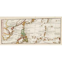
No title: Map of Philippines, Taiwan and China.
Interesting map centred on the Philippines. Showing the tracks of Byron, Wallis and Marshall.
Date: Vienna 1790
Selling price: ????
Please login to see price!
Sold in 2017
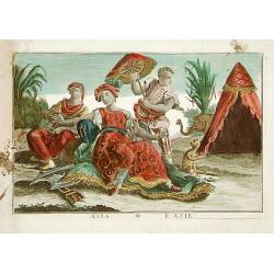
Asia / L'Asie: Asia personified as a woman.
A woman setting on a carpet and surrounded by two servants, an elephant and a monkey.
Date: France c. 1790
Selling price: ????
Please login to see price!
Sold in 2015
Chine, et Indes Avec les Isles avec les Isles, d'après les descriptions les plus exactes . . . 1790.
Attractive map of southern Asia, most of the East Indies, including China, Malaysia, Java, Borneo and the Philippines.Extending westwards to include India, the northern r...
Date: Paris, 1790
Selling price: ????
Please login to see price!
Sold in 2018
L' Asie Dressée pour l' étude de la Géographie..
Highly decorative map of Asia embellished with a landscape style title cartouche and several sailing ships.The map is of interest for the use of Mer de Corée, the sea be...
Date: Paris, 1790
Selling price: ????
Please login to see price!
Sold in 2010
Carte Generale des Indes Orientales..
Uncommon map of South East Asia based on Jansson's map of 1641, with good detail on Philippines. Showing Taiwan and the Southern part of Japan. Many Dutch names especiall...
Date: Paris, 1790
Selling price: ????
Please login to see price!
Sold in 2011
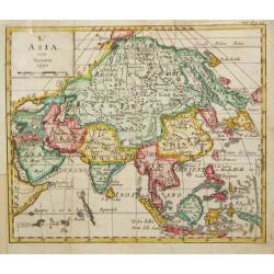
L' Asia.
A small map depicting the Asia continent, from the Italian edition of Claude Buffier's ' Geographie Universelle'.
Date: Venice, 1790
Selling price: ????
Please login to see price!
Sold in 2009

Vue de La Place et de la Fontaine de Top-Hané.
So-called optical print of Tophane and Kılıç Ali Paşa Mosque. In the eighteenth and nineteenth centuries there were many popular speciality es...
Date: Paris, 1790
Selling price: ????
Please login to see price!
Sold
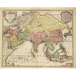
Carte de Asie dresse´e pour l'instruction / par Guil. Delisle et Phil. Buache ? nouvellement revue et augmentee´ par Dezauche.
Map of Asia. Relief shown pictorially. Small inset map on the upper right corner. Published by Dezauche.Notable for depiction of Hokkaido, here called "I.Chicha ou J...
Date: Paris, ca. 1790
Selling price: ????
Please login to see price!
Sold in 2009
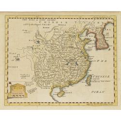
China.
Map of China, including Taiwan and Korea.
Date: London, c. 1790
Selling price: ????
Please login to see price!
Sold in 2010
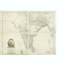
Presqu 'Isle Des Indes Orientales,..
Detailed map of India with inset map (220x155mm) of the entree of the river Ganges. With decorative scene with an elephant underneath the title cartouche.
Date: Paris, 1790
Selling price: ????
Please login to see price!
Sold in 2012
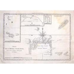
Isles de la Reine Charlotte.
These are the Santa Cruz Islands now, near the Solomon Islands. There are three inserts including the islands of Carteret, Hirondelle and bay of Byron. The centered overs...
Date: Paris, 1790
Selling price: ????
Please login to see price!
Sold in 2014
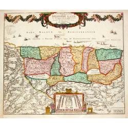
Carte des Indes en deça et au delà du Gange. . .
A copper engraved map.
Date: Venise, 1790
Selling price: ????
Please login to see price!
Sold in 2017
Carte du Bengale avec la Partie Septentrionale des Etats du Roi D'Aua.
A detailed eighteenth century map of Bengal, India with Calcutta prominently marked, and the Ganges up to Patna, and that part which is modern Bangladesh. From Brunet's '...
Date: Paris, 1790
Selling price: ????
Please login to see price!
Sold in 2019
Carte des Indes en Deca et au Dela du Gange, avec les Isles de la Sonde, Borneo, les Moluqes et les Philippines partie Orientale. Par M. Bonne, ingenieur Hydrographe de la Marine. A' Venise, Par P. Santini 1790.
A copper engraved map, prepared by R. Bonne and L'Abbe Grenet from "Atlas portatif a l'usage des colleges, pour servir a l'intelligence des auteurs classiques. Par M...
Date: Venice, 1790
Selling price: ????
Please login to see price!
Sold in 2018
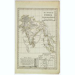
Ad Antiquam Indiae Geographiam Tabula.
A map of the ancient map of the Indian subcontinent, with an inset of Taprobana (Ceylon / Sri Lanka), next to a set of mileage scales, in the shape of a slab of rock. Pla...
Date: Anon, ca 1790
Selling price: ????
Please login to see price!
Sold in 2020
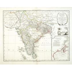
Presqu 'Isle Des Indes Orientales. . .
A nice large and detailed map of India by de Vaugondy with inset map of the entree of the river Ganges.
Date: Paris, 1790
Selling price: ????
Please login to see price!
Sold in 2018
Presqu 'Isle Des Indes Orientales. . .
A nice large and detailed map of India by de Vaugondy with inset map of the entree of the river Ganges. With a decorative scene with an elephant underneath the title cart...
Date: Paris, 1790
Selling price: ????
Please login to see price!
Sold in 2019
![[Map of Asia in Cyrillic]. Аз1я Раздѣле нная на](/uploads/cache/44338-250x250.jpg)
[Map of Asia in Cyrillic]. Аз1я Раздѣле нная на
A map of Asia. Аз1я Раздѣле нная наThe map is interesting for use of "Sea of Korea" for the sea between Korea and Japan.This Cyrillic version of...
Date: Paris / St.Petersburg, ca. 1790
Selling price: ????
Please login to see price!
Sold in 2023
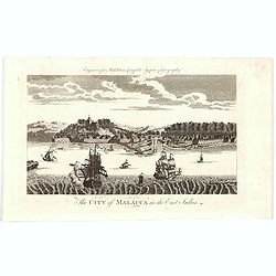
The City of Malacca in the East Indies.
A late eighteenth century copperplate view of the Malaysian city of Malacca - the oldest city on the straights of Malacca. The city entrance from the Malacca River is cle...
Date: London, 1790
Selling price: ????
Please login to see price!
Sold in 2020
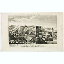
A Perspective View of the Church of the Holy Sepulchre at Jerusalem, and other Structures.
A nice copperplate engraving of the main churches to be found in Jerusalem toward the end of the eighteen century. Beneath the engraving is a lettered table of the tower...
Date: London, ca 1790
Selling price: ????
Please login to see price!
Sold in 2023
Stato del Mogol con le Coste del Malabar..
Fine map of India including Ceylon.
Date: Venice 1791
Selling price: ????
Please login to see price!
Sold
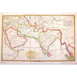
Carte d'Asie divisé en ses différénts Empires et Royaumes avec les nouvelles découvertes faîtes au Nord par différents voyageurs
Uncommon French map of Asia with fine title cartouche upper left. Inset map of Bering Strait.The map is of interest for the use of East Sea, the sea between Korea and Jap...
Date: Paris, 1791
Selling price: ????
Please login to see price!
Sold in 2012
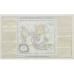
Map of the South East Part of Asia.
This important map of Southeast Asia was produced for Dr. Robertson's Historical Disquisition, published in England by Cadell in 1791. It depicts the knowledge that Ancie...
Date: London, 1791
Selling price: ????
Please login to see price!
Sold in 2014
Plan of the Kurile Islands and Lands Little Known. . .
A fine copperplate chart of the Kirile Islands. From La Perouse’s ATLAS DU VOYAGE DE LA PEROUSE. Published by G.G & J. Robinson in London in 1798. Engraved by Neale...
Date: London, 1791
Selling price: ????
Please login to see price!
Sold in 2018
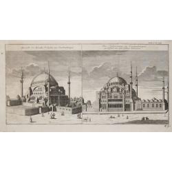
Aussicht der Kirchie St. Sophie zu Constantinopel / Die Solimannie zu Constantinopel, gestifftet von den dem Sultan Solimann.
From 'Algemeine Welthistorie (der Neuern Zeiten)', edited by S.J.Baumgarten, J.S.Semler a.o.The Sofia and the Soliman Moskee in Istanbul.
Date: Halle, 1763-1792
Selling price: ????
Please login to see price!
Sold
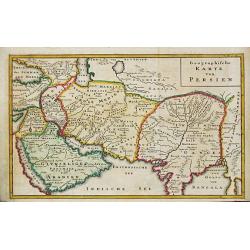
Geographische Karte von Persien. Arabia
From 'Algemeine Welthistorie (der Neuern Zeiten)', edited by S.J.Baumgarten, J.S.Semler a.o.A map of ancient Persia.
Date: Halle, 1763-1792
Selling price: ????
Please login to see price!
Sold in 2019
L \' Asie Divisee en ses Empires, Royaumes et Etats.
Jan Berend Elwe. Amsterdam-based publisher. Published a pocket-atlas of the Netherlands (1786) and of Germany (1791). Publised in 1792 a folio-atlas with 37 maps.Topograp...
Date: Amsterdam, 1792
Selling price: ????
Please login to see price!
Sold in 2011
Generaale Kaart van het Beloofde Land.
Jan Berend Elwe. Amsterdam-based publisher. Published a pocket-atlas of the Netherlands (1786) and of Germany (1791). Publised in 1792 a folio-atlas with 37 maps.
Date: Amsterdam, 1792
Selling price: ????
Please login to see price!
Sold
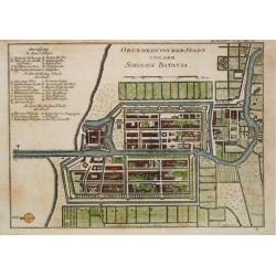
Grundriss von der Stadt und dem Schlosse Batavia.
From 'Algemeine Welthistorie (der Neuern Zeiten)'.
Date: Halle, 1763-1792
Selling price: ????
Please login to see price!
Sold in 2017
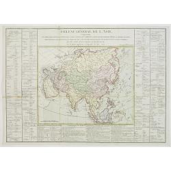
Tableau général de L\'Asie,..
Uncommon map of Asia showing the tracks of Cook (1771-73, 1771 and Clarcke (1779) and the Spanish galleons visiting the Philippines. Surrounded by geographical informatio...
Date: Paris, 1792
Selling price: ????
Please login to see price!
Sold in 2008

Aussicht und Grundriss der Moschee des Soltan Ahmed.
From 'Algemeine Welthistorie (der Neuern Zeiten)', edited by S.J.Baumgarten, J.S.Semler a.o.A view and plan of the Moskee of Sultan Ahmed.
Date: Halle, 1763-1792
Selling price: ????
Please login to see price!
Sold
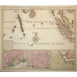
Partie de la Nouvelle Grande Carte des Indes Orientales.. 4 parts
Decorative and complete set of four scarce maps detailing all of Southeast Asia, filled with meticulous topography and place names.1) Partie de la Nouvelle Grande Carte d...
Date: Amsterdam, 1792
Selling price: ????
Please login to see price!
Sold in 2008
Partie de la Nouvelle Grande Carte des Indes Orientales.. 4 parts
Decorative and complete set of four scarce maps detailing all of Southeast Asia, filled with meticulous topography and place names.1) Partie de la Nouvelle Grande Carte d...
Date: Amsterdam, 1792
Selling price: ????
Please login to see price!
Sold in 2010
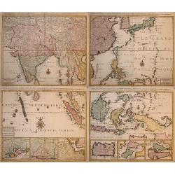
![[Wall map in 4 sheets] Partie de la nouvelle grande carte des Indes Orientales. . .](/uploads/cache/01041-250x250.jpg)
[Wall map in 4 sheets] Partie de la nouvelle grande carte des Indes Orientales. . .
Decorative and complete set of four scarce maps here in its first edition detailing all of Southeast Asia, filled with meticulous topography and place names.1) Partie de ...
Date: Amsterdam, 1792
Selling price: ????
Please login to see price!
Sold in 2010
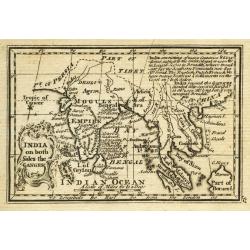
India on both Sides the Ganges.
Uncommon miniature map from Gibson's "Atlas Minimus, or a New Set of Pocket Maps of the several Empires, Kingdoms and States of the known World".
Date: London, 1792
Selling price: ????
Please login to see price!
Sold in 2011
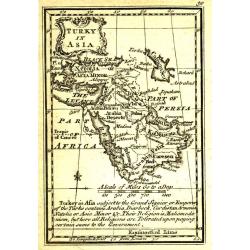
Turky in Asia.
Uncommon miniature map from Gibson's "Atlas Minimus, or a New Set of Pocket Maps of the several Empires, Kingdoms and States of the known World".
Date: London, 1792
Selling price: ????
Please login to see price!
Sold in 2011
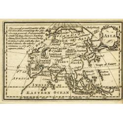
Asia.
Uncommon miniature map from Gibson's "Atlas Minimus, or a New Set of Pocket Maps of the several Empires, Kingdoms and States of the known World".
Date: London, 1792
Selling price: ????
Please login to see price!
Sold in 2011
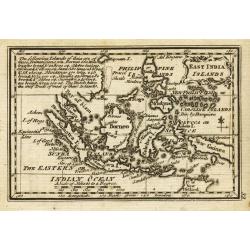
East India Islands.
Uncommon miniature map from Gibson's "Atlas Minimus, or a New Set of Pocket Maps of the several Empires, Kingdoms and States of the known World".
Date: London, 1792
Selling price: ????
Please login to see price!
Sold in 2011
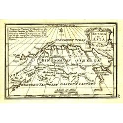
Russia in Asia.
Uncommon miniature map from Gibson's "Atlas Minimus, or a New Set of Pocket Maps of the several Empires, Kingdoms and States of the known World".
Date: London, 1792
Selling price: ????
Please login to see price!
Sold in 2011
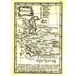
Persia.
Uncommon miniature map from Gibson's "Atlas Minimus, or a New Set of Pocket Maps of the several Empires, Kingdoms and States of the known World".
Date: London, 1792
Selling price: ????
Please login to see price!
Sold in 2011
L'Asie Divisee en ses Empires Royaumes et Etats.
Attractive and quite detailed map of the Asian continent. Shows cities, towns, rivers, mountain ranges etc.Covers the area from the East African coast to New Guinea and f...
Date: Amsterdam, 1792
Selling price: ????
Please login to see price!
Sold in 2012
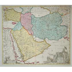
Carte de la Perse de l'Armenie de la Natolie & de l'Arabie by Jan B Elwe MDCCXCII
This large map covers the region from Turkey through Iran, featuring the Arabian Peninsula prominently. The title cartouche shows the strategic importance of the region a...
Date: Amsterdam, 1792
Selling price: ????
Please login to see price!
Sold in 2014
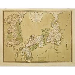
Empire de la Chine, Rme. de Coree et Isles du Japon.
Rare issue by Pere Francesco Santini of a map originally by Rigobert Bonne.
Date: Venice, 1792
Selling price: ????
Please login to see price!
Sold in 2012
Asien nach den neusten und besten Hülfsmitteln entworffen und herausgegeben im Jahre 1793
Scarce map of Asia with good detail of Indonesia and Philippines, showing New Guinee and the Northern tips of Australia labeled "Neu Holland" and Neu Süd Walli...
Date: Nuremberg, 1792
Selling price: ????
Please login to see price!
Sold in 2016
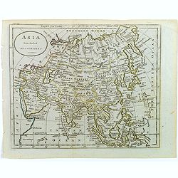
Asia from the best Authorities.
A quaint small map of the continent of Asia as it was at the end of the eighteenth century. For a small map, it has good cartographic detail.The map extent is from the Me...
Date: London, ca. 1792
Selling price: ????
Please login to see price!
Sold in 2023
Empire de la Chine, Rme. de Coree et Isles du Japon.
Rare Italian issue of Rigobert Bonne's map of China, Korea, and Japan, by Pere Francesco Santini.
Date: Venice, 1792
Selling price: ????
Please login to see price!
Sold in 2017
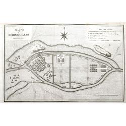
Island of Seringapatam.
A scarce map of Srirangapatna, (also Shrirangapattana) in Mandya district of the Indian state of Karnataka. Located near the city of Mysore. The entire town is enclosed b...
Date: London, ca. 1792
Selling price: ????
Please login to see price!
Sold in 2022
![[Lot of 7 maps of the lands bordering the Red Sea]](/uploads/cache/20680-250x250.jpg)
[Lot of 7 maps of the lands bordering the Red Sea]
Jan Elwe’s re-issue of Guillaume de l’Isle’s 1707 map of the lands bordering the Red Sea, showing Arabia distinctively.Jan Berend Elwe. Amsterdam-based publisher. P...
Date: Paris, 1792
Selling price: ????
Please login to see price!
Sold in 2022
Lacs, Fleuves, Rivieres et Principales Montagnes de L'Asie.
Interesting map of the lakes, rivers and mountains of Asia. Featuring Siberia, India and China. The history of the region is featured to the sides. Published by Mondhare ...
Date: Paris, 1793
Selling price: ????
Please login to see price!
Sold in 2018
Asien nach den neusten und besten Hülfsmitteln entworffen und herausgegeben im Jahre 1793
Scarce map of Asia with good detail of Indonesia and Philippines, showing New Guinea and the Northern tips of Australia labelled "Neu Holland" and Neu Süd Wall...
Date: Nuremberg, ca 1793
Selling price: ????
Please login to see price!
Sold in 2017
This chart .. tracks of ships in the different monsoons..
Curious over-sized prepared by Benjamin Lacam, showing the Indian Ocean, including Cape of Good Hope, Arabia, India and Malay Peninsula. In the Ocean several tracks are ...
Date: London, 1794
Selling price: ????
Please login to see price!
Sold in 2018
The Empire of Japan divided into seven principal parts and subdivided into sixty-six kingdoms, with the Kingdom of Corea, from Kempfer and the Portuguese.
Detailed map of Japan and Korea prepared by Kaempfer and published in London by Laurie and Whittle, from "New Universal Atlas".The map is of interest for the us...
Date: London, 1794
Selling price: ????
Please login to see price!
Sold in 2010
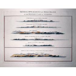
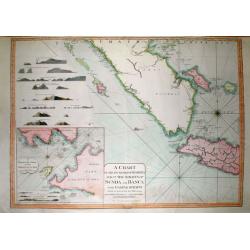
Several Appearances of Hogs Island on the Western Coast of Sumatra.
RARE sheet from "The country East-India Pilot" published in 1799 by Laurie & Whittle. Interesting copper engraved sheet with five views of Hogs Island and ...
Date: London, 1794
Selling price: ????
Please login to see price!
Sold in 2011
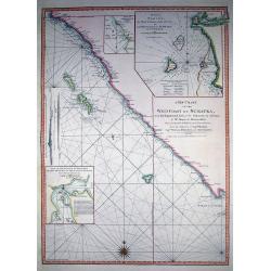
A New Chart of the West Coast of Sumatra,...
SCARCE nautical from "The country East-India Pilot" published in 1799 by Laurie & Whittle. Great copper engraved map of Western Sumatra and Nassau or Pogg...
Date: London, 1794
Selling price: ????
Please login to see price!
Sold in 2011
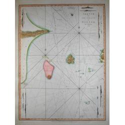
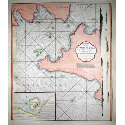
Sketch of the Straits of Gaspar...
SCARCE nautical after J. Huddart 1788, published in "The country East-India Pilot" in 1799 by Laurie & Whittle. Great copper engraved map the Strait of Ga...
Date: London, 1794
Selling price: ????
Please login to see price!
Sold in 2011
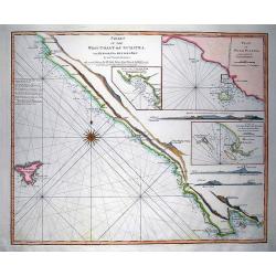
Chart of the West Coast of Sumatra, from Bencoolen to Key Sers Bay.
RARE nautical from "The country East-India Pilot" published in 1799 by Laurie & Whittle. Superb copper engraved map Western Sumatra with Isle Engano or De...
Date: London, 1794
Selling price: ????
Please login to see price!
Sold in 2011
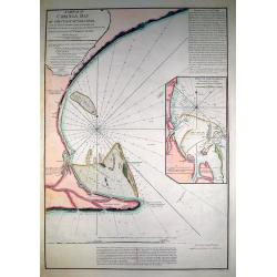
A Sketch of Coringa Bay...
RARE nautical from "The country East-India Pilot" published in 1799 by Laurie & Whittle. Engraved by Neele, after Capt. Lesley 1774. Great copper engraved...
Date: London, 1794
Selling price: ????
Please login to see price!
Sold in 2011
A Chart of the Straits of Sunda, from Point Winerow to North Island...
SCARCE nautical from "The country East-India Pilot" published in 1799 by Laurie & Whittle. After D'Apres de Mannevillette's map from his Neptune Oriental. ...
Date: London, 1794
Selling price: ????
Please login to see price!
Sold in 2011
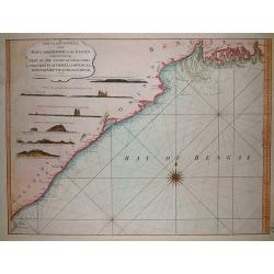
The coast of India, from Point Gordeware to the Ganges comprehending part of the coast of Golconda the coasts of Orissa and Bengal, with the mouth of the Hoogly river
SCARCE sea from "The country East-India Pilot" published in 1799 by Laurie & Whittle. The copper engraved map extends from the Coringa Bay to the Ganges r...
Date: London, 1794
Selling price: ????
Please login to see price!
Sold in 2011
A Chart of the Coast of Pegu with the Adjacent Coast of Arakan and Tanasserim...
SCARCE from "The country East-India Pilot" published in 1799 by Laurie & Whittle. Very large copper engraved map of the area of Pego (nowadays Bago) in Bur...
Date: London, 1794
Selling price: ????
Please login to see price!
Sold in 2011
A Chart of the South Part of Sumatra and of the Straits of Sunda and Banca with Gaspar Straits...
SCARCE nautical from "The country East-India Pilot" published in 1799 by Laurie & Whittle. Large copper engraved map displaying parts of Sumatra and Java. ...
Date: London, 1794
Selling price: ????
Please login to see price!
Sold in 2011
![[No tittle] Lac salé de Bogdo Montagne de Bogdo.](/uploads/cache/29184-250x250.jpg)
[No tittle] Lac salé de Bogdo Montagne de Bogdo.
Map of Mountains and the Salt Lake of Bogdo in Russia near the border of Kazakhstan, from a second French edition of Peter Simon Pallas' Voyages du Professeur Pallas, dan...
Date: Paris, Maradan, 1794
Selling price: ????
Please login to see price!
Sold in 2012