Sign In or Sign Up
Subscribe to be notified if similar examples become available.
1784 TIEFENTALLER, Joseph. - Carte Generale du Cours du Gange et du Gagra. . .
Carte Generale du Cours du Gange et du Gagra. . .
| Maker: | TIEFENTALLER, Joseph. | |
| Date: | Paris ca 1784 | |
| Colored: | Uncolored. | |
| Size: | 595 x 745 mm / 23.4 x 29.3 inches | |
| Condition: | In good condition, with multi-folds now flattered out, some light creasing to margins, a few tiny nicks and paper tears to margins etc. Left margin tight. - others adequate. Lightly age toned. | |
Selling price: $ Please login to see price!
Sold in 2023
Missed this item!
Add your name to our mailing list and be the first to get notified about our newly added listings.
.
You can choose from more than 30,000 items from our BuyNow Catalog or Archive.
It's free, and you can delete items from your to your Collection+ anytime.
 Add/Remove


Description
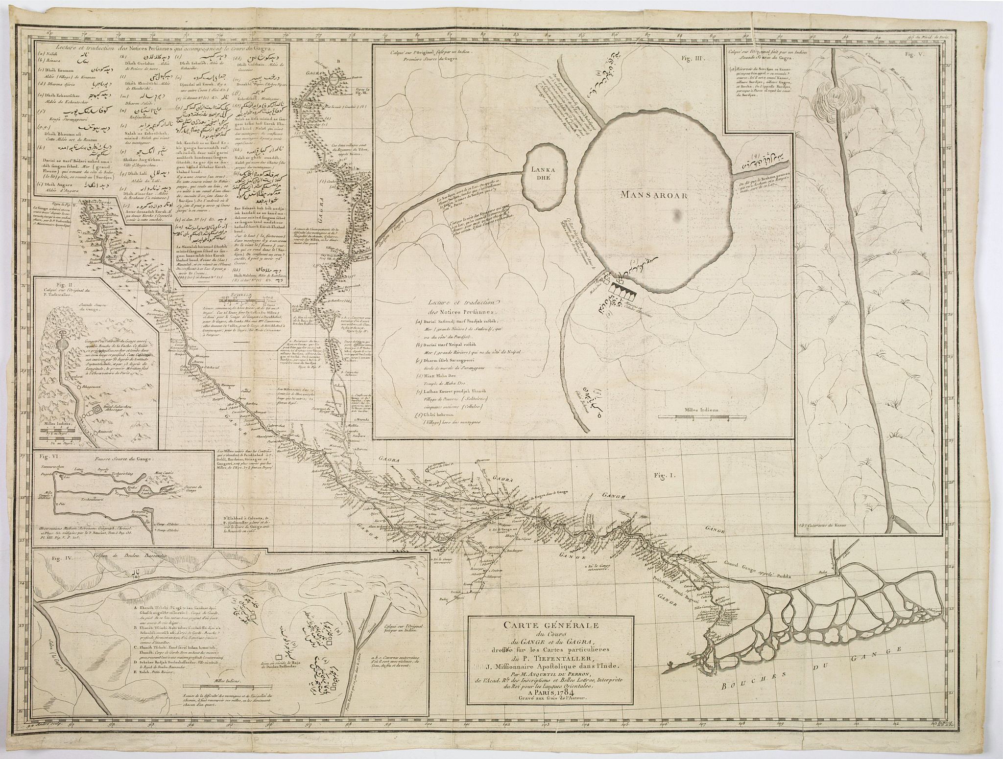
A large chart with six inset maps printed on one sheet by the Jesuit Joseph Tiefentaller in the latter half of the eighteenth century. The map is in French and in Persian.
Figure I is the entire course of the Ganges and Ghahara Rivers is a European-style map produced by Tiefenthaler based upon his own travels
and quadrant surveys as well as on the indigenous cartography he
collected along the way. Four of the five smaller maps presented are Tiefenthaler’s copies of Indian maps given to or provided for him.
The stylistic difference between these and the central European style
map is clear, especially regarding the rendering of direction,
bodies of water, and topography.
Figure II locates the source of the Ganges at the Gangotri Glacier,
Gaumukah, known as the “Cow’s Mouth” due to its strong resemblance to
the open mouth of a cow.
Fig III shows the Lake of Mansarovar
(Mansaroar), the supposed source of the Karnali or Ghaghara River. It is
unlikely that Tiefenthaler actually ever say Mansarovar as this lake is
located high on the Tibetan Plateau which, during this historic period,
was closed to foreigners.
Fig IV shows the sources around the volcano of Doulou Bassandar.
Fig V shows the Ganghara River as it runs through the Himalayan Mountains.
Figure VI depicts earlier misconceptions regarding the source
of the Ganges as suggested by P. Souciet in his 1729 four volume work
Observations, Mathematical, Astronomical, Geographica, Chronological,
and Physical . Fig VI depicts the earlier mistakes regarding the source of the Ganges River. Tiefentaller was an Austrian, who became a Jesuit, and moved to Spain in 1740, then from Portugal to Goa in 1742, and finally to Agra in India. To work at the Jesuit college there.
The Persian text is claimed to have come from reliable local sources, they were then (loosely) translated into French in a table in the top left corner of the chart.
The map is drawn from the manuscripts of Joseph Tieffentaller, a Jesuit missionary and one of the earliest European geographers to write about India. Tieffentaller was a fine scholar with an unusual talent for languages, as evidenced in this map that includes numerous notation in Persian script in each of the maps Tiefenthaler claims to have copied from indigenous sources.
One of the most striking elements of this map is the inclusion of Pesian text in each of the maps Tiefenthaler claims to have copied from indigenous sources. These text blocks are vaguely transliterated and translated into French in a table in the upper left quadrant.
Most of the cartographic work that led to this map was completed by Tiefenthaler in India. Tiefenthaler, near the end of his life, forwarded it to his friend and fellow orientalist Anquetil-Duperron, living at the time in Paris. Duperron, a noted orientalist, compiled Tiefenthaler’s research and sketches into this important independently issued map. Though significant in its time this map is little known by modern cartographic historians who, when discussing the mapping of India, tend to focus on the later work of Rennell.
Reference: Gole, 1983: 102 2.1; Sommervogel, Vol VIII, column 21 & 22; Edney p 133.
FAQ - Guarantee - Shipping
This item is available for immediate purchase when a "Add to Cart" or "Inquire Now" button is shown.
Payments are accepted in Euros or US Dollars. We accept most major credit cards, PayPal and bank transfer.
Authenticity Guarantee
 We provide professional descriptions, condition report and HiBCoR rating (based on 45 years experience in the map business)
We fully guarantee the authenticity of items we sell. We provide a certificate of authenticity for each purchased item.
Condition / Coloring
We indicate the condition of each item and use our unnique HiBCoR grading system in which four key items determine a map's value: Historical Importance, Beauty, Condition/Coloring and Rarity.
We offer many maps in their original black and white condition. We do not systematically color-up maps to make them more sellable to the general public or buyer.
Copper engraved or wood block maps are always hand colored. Maps were initially colored for aesthetic reasons and to improve readability. Nowadays, it is becoming a challenge to find maps in their original colors and are therefor more valuable.
We use the following color keys in our catalog:
Original colors; mean that the colors have been applied around the time the map was issued.
Colored; If the colors are applied recently or at the end of the 20th century, then "colored", or "attractive colors" will be used.
Original o/l colors; means the map has only the borders colored at the time of publication.
Read more about coloring of maps [+]
FAQ
Please have a look for more information about buying in the BuyNow gallery.
Many answers are likely to find in the general help section.
My Collection+

With My Collection+ you can collect all your favorite items in one place. It is free, and anyone can create his or her virtual map collection.
Unless you are logged in, the item is only saved for this session. You have to be registed and logged-in if you want to save this item permanently to My Collection+. Read More [+]
If you want to save the items permanently, please sign in
or create account first.

Registering Here, it is and you do not need a credit card.
Add this item to My Collection+ or click the following link to see My Collection+.
Invoice
The invoice and certificates of authenticity are available in the client center >Invoices
|
Digital Image Download Paulus Swaen maintains an archive of most of our high-resolution rare maps, prints, posters and medieval manuscript scans. We make them freely available for download and study. Read more about free image download |
Click the image for a free small image download. |
YOUR RIGHT TO CANCEL THE PURCHASE OF A LOT
In accordance with the EU Consumer Rights Directive and habitually reside in the European Union you have the right to cancel the contract for the purchase of a lot, without giving any reason.
The cancellation period will expire 14 calendar days from the day after the date on which you or a third party (other than the carrier and indicated by you) acquires, physical possession of the lot. To exercise the right to cancel you must inform Paulus Swaen Inc, of your decision to cancel this contract by a clear statement (e.g. a letter sent by post, or e-mail.
To meet the cancellation deadline, it is sufficient for you to send your communication concerning your exercise of the right to cancel before the cancellation period has expired.
