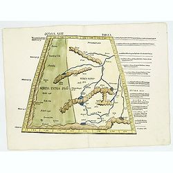
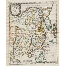
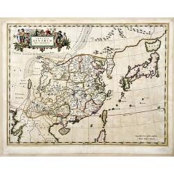
Octava Asie Tabvla.
Wood block map of Central Asia and China from Martin Waldseemüller's 1513 edition of Ptolemy, who was a landmark work that contributed to major advances in both Renaissa...
Date: Strasbourg, J. Schott, 1513
Selling price: ????
Please login to see price!
Sold in 2018
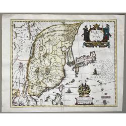
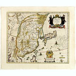
![No title. [China and Japan.]](/uploads/cache/27893-250x250.jpg)
No title. [China and Japan.]
The earliest printed representation of the China and Japan region in a European Atlas. The first issue of this engraving with minor titular amendments appeared in the 152...
Date: Lyons, M. Servetus, 1535
Selling price: ????
Please login to see price!
Sold in 2009
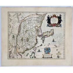
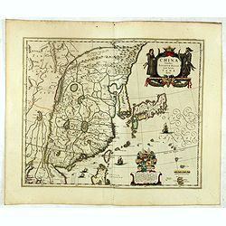
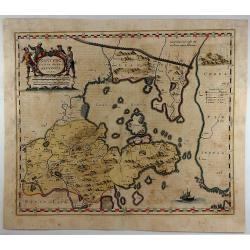
![No title. [China and Japan.]](/uploads/cache/01626-250x250.jpg)
No title. [China and Japan.]
The earliest printed representation of the China and Japan region in a European Atlas. The first issue of this engraving with minor titular amendments appeared in the 152...
Date: Vienne 1541
Selling price: ????
Please login to see price!
Sold
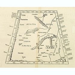
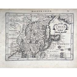
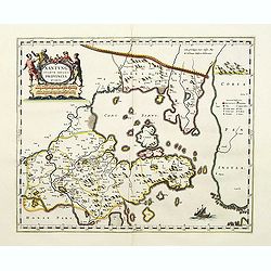
Tabula octava Asiae continet.
Woodblock map illustrating the Ptolemaic concept of the region of ancient Schytia Extra in a trapezoidal projection. Title is on verso.Central Asia and China with the cou...
Date: Vienne, 1541
Selling price: ????
Please login to see price!
Sold in 2009
![[Lot of 17 leaves with maps and views relating to India, Sri Lanka, China, Indonesia]](/uploads/cache/48280-250x250.jpg)
[Lot of 17 leaves with maps and views relating to India, Sri Lanka, China, Indonesia]
Seventeen text pages illustrated with wood block prints relating to India, Sri Lanka, China, Indonesia illustrated with animals : elephants, rhinoceros... From the 1552 L...
Date: Basel, 1552
Selling price: ????
Please login to see price!
Sold in 2022
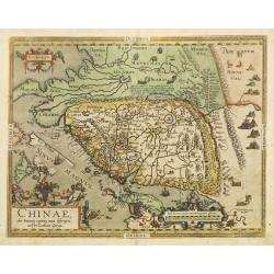
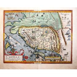
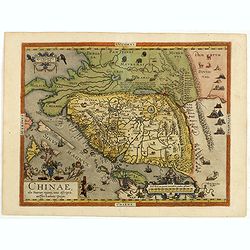
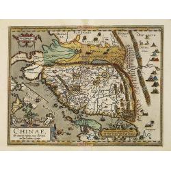
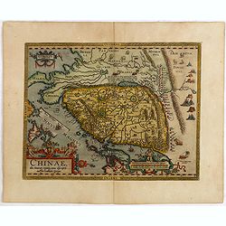
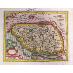
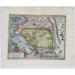
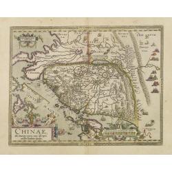
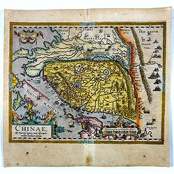
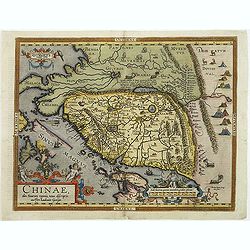
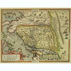
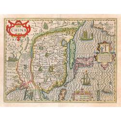
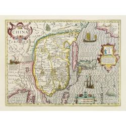
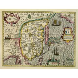
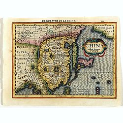
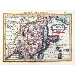
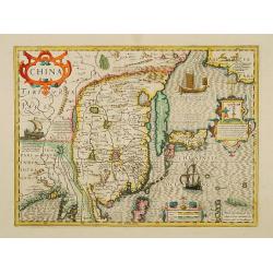
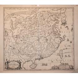
Chinae, olim Sinarum Regionis, nova descriptio. auctore Ludovico Georgio.
The first map of China ever to appear in a Western atlas, west to the top. When this map appeared, it was by far the most accurate one of China.Japan is shown on a curiou...
Date: Antwerp 1584
Selling price: ????
Please login to see price!
Sold
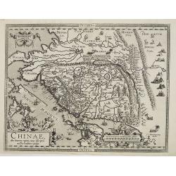
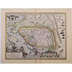
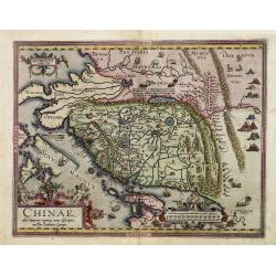
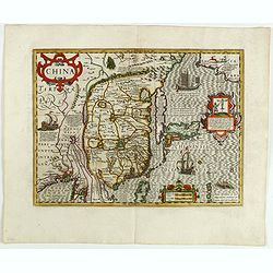
Chinae, olim Sinarum regionis, nova descriptio. Auctore Ludovico Georgio.
Engraved map of China with an elaborate baroque title and scale cartouches, galleons and masted land-vehicles. Latin text on verso.This map, drawn by Ludovicus Georgius (...
Date: Antwerp, 1584
Selling price: ????
Please login to see price!
Sold in 2011
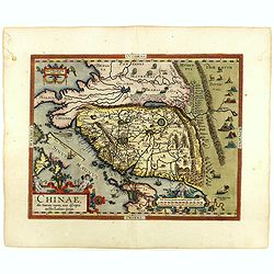
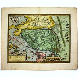
Chinae Olim Sinarum Regionis Nova Descriptio auctore Ludovico Georgio.
The first map of China which appeared in a western atlas. From a Latin edition of 1592 (latin text on verso, page 101, last line"moribus exilat...").This map, i...
Date: Antwerp, 1584
Selling price: ????
Please login to see price!
Sold in 2017
Chinae, olim Sinarum Regionis, nova descriptio. Auctore Ludovico Georgio.
A first state, the first issue of the first map of China to appear in a Western atlas [without "Las Philippinas"; Latin text to verso, the last line starts &quo...
Date: Antwerp, 1584
Selling price: ????
Please login to see price!
Sold in 2018
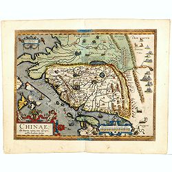
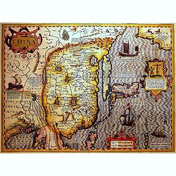
Chinae, olim Sinarum Regionis, nova descriptio. Auctore Ludovico Georgio.
The first map of China ever to appear in a Western atlas, west to the top. When this map appeared, it was by far the most accurate one of China.Japan is shown on a curiou...
Date: Antwerp, 1587
Selling price: ????
Please login to see price!
Sold in 2014
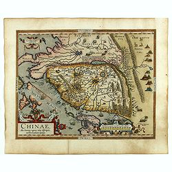
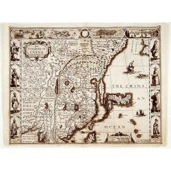
Chinae, olim Sinarum Regionis, nova descriptio. Auctore Ludovico Georgio.
WITHOUT TEXT ON VERSO. The first map of China ever to appear in a Western atlas, west to the top. The second state with "Las Philipinas" somewhere in 1587 added...
Date: Antwerp, ca. 1587
Selling price: ????
Please login to see price!
Sold in 2019
Chinae, olim Sinarum Regionis, nova descriptio. Auctore Ludovico Georgio.
The first map of China ever to appear in a Western atlas, west to the top. When this map appeared, it was by far the most accurate one of China.Japan is shown on a curiou...
Date: Antwerp, after 1588
Selling price: ????
Please login to see price!
Sold in 2015
Chinae, olim Sinarum Regionis, nova descriptio. Auctore Ludovico Georgio.
From the rare Dutch text edition of the Theatrum of which according to van den Broecke only 100 copies are printed.The first map of China ever to appear in a Western atla...
Date: Antwerp, 1598
Selling price: ????
Please login to see price!
Sold in 2016
Chinae, olim Sinarum Regionis, nova descriptio. Auctore Ludovico Georgio.
The first map of China ever to appear in a Western atlas, west to the top. The second state with "Las Philipinas" somewhere in 1587 added to the plate. When thi...
Date: Antwerp, 1598
Selling price: ????
Please login to see price!
Sold in 2018
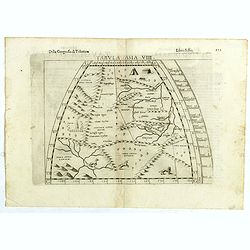
Tabula Asiae VIII.
The third state of Ruscelli's map of central Asia, based upon Claudius Ptolemy. Girolamo Ruscelli first published the map in his "La Geographi di Claudio Tolomeo&quo...
Date: Venice, 1598
Selling price: ????
Please login to see price!
Sold in 2018
Floating Tea House in China.
This famous and desirable scene from Linschoten's famous voyages to the East of 1583-1592 here published by De Bry the year after they first appeared as a separate book. ...
Date: Frankfurt, 1599
Selling price: ????
Please login to see price!
Sold in 2012
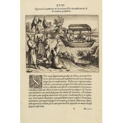
Transport of China
Scene of a "Chinese" landscape with a wind carriage and the transportation of a noble woman from Linschoten's famous voyages to the East of 1583-92 here publish...
Date: Frankfurt, 1599
Selling price: ????
Please login to see price!
Sold in 2013

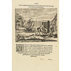
Mirae Chinensium ceremoniae, quibus in sacris & diuino cultu vtuntur.
A religious scene in China Linschoten's famous voyages to the East of 1583-92 here published by De Bry the year after they first appeared as a separate book. From Part II...
Date: Frankfurt, 1599
Selling price: ????
Please login to see price!
Sold in 2021
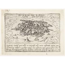
Quinzai.
Uncommon plan of Quinzai (in China) with its bridges from Francesco Valegio's townbook: Raccolta di le piv illustri et farmose citta di tutto il mondo.
Date: Venice 1600
Selling price: ????
Please login to see price!
Sold
![Quinzai. [Hangzhou]](/uploads/cache/25263-250x250.jpg)
Quinzai. [Hangzhou]
Uncommon and one of the earliest western prints, showing a bird's eye view of Hangzhou. From Francesco Valegio's townbook: Raccolta di le piv illustri et farmose citta di...
Date: Venice, 1600
Selling price: ????
Please login to see price!
Sold in 2008
Chinae, olim Sinarum Regionis, nova descriptio. Auctore Ludovico Georgio.
The first map of China ever to appear in a Western atlas, west to the top. When this map appeared, it was by far the most accurate one of China.Japan is shown on a curiou...
Date: Antwerp, 1601
Selling price: ????
Please login to see price!
Sold in 2010
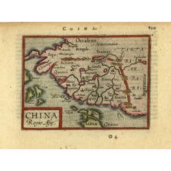
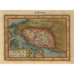
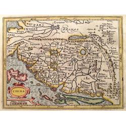
China, Regio Asiae.
This is the miniature version of Ortelius' important map focusing on China. The map is oriented with north to the right and extends to include parts of Indo-China. The Gr...
Date: Antwerp, ca.1602
Selling price: ????
Please login to see price!
Sold in 2008
Chinae, olim Sinarum Regionis, nova descriptio. Auctore Ludovico Georgio.
The first map of China ever to appear in a Western atlas, west to the top. When this map appeared, it was by far the most accurate one of China.Japan is shown on a curiou...
Date: Antwerp, 1603
Selling price: ????
Please login to see price!
Sold in 2016
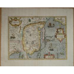
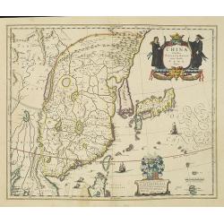
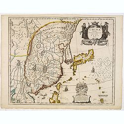
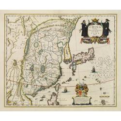
China.
An important and decorative map of China, Korea and Japan, decorated with three cartouches, ships, China’s great wall, and sea monsters. It shows also a sail-cart and a...
Date: Amsterdam, 1606
Selling price: ????
Please login to see price!
Sold in 2019
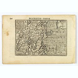
China.
A miniature map of China. It also shows a portion of western America, Indo-China, the Philippines, Borneo, Japan and Korea. Published by Petrus Bertius in Amsterdam, at t...
Date: Amsterdam, 1606
Selling price: ????
Please login to see price!
Sold in 2019
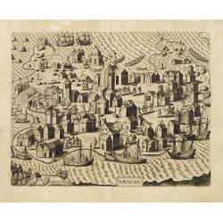
AMACAO.
One of the splendid engravings from the Voyages of de Bry, this full double-page view shows the artist's conception of Macao. Macao had quickly became a strategic strongh...
Date: Frankfurt 1607
Selling price: ????
Please login to see price!
Sold
China.
Rare first issue, first state of Hondius' reduced map of China, from Atlas Minor Gerardi Mercatoris. Most notable differences from the second state include the spelling o...
Date: Amsterdam, 1607
Selling price: ????
Please login to see price!
Sold in 2013
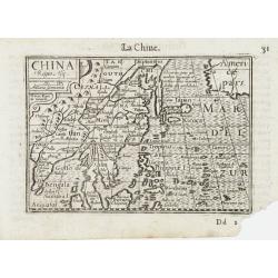
China.
Charming small map of the eastern part of China, oriented with west on top. It includes part of Japan and Korea represented as an island.From the first French-text editio...
Date: Amsterdam, 1608
Selling price: ????
Please login to see price!
Sold in 2009
Chinae Olim Sinarum Regionis Nova Descriptio auctore Ludovico Georgio.
The first map of China to appear in a western atlas by Abraham Ortelius, based on the work of Jorge de Barbuda, a Portuguese Jesuit also known as Ludovicus Georgius. The...
Date: Antwerp, 1587/1608
Selling price: ????
Please login to see price!
Sold in 2020
China, regio Asiae.
Miniature map of China, the map is oriented with north to the right and extends into parts of Indo-China, the Philippines and part of Japan. The Great Wall is prominently...
Date: Antwerp 1609
Selling price: ????
Please login to see price!
Sold
China.
A miniature map of China, including the islands of Mindanao, Philippines, Borneo, Japan, etc. Title cartouche in the upper left corner.First published in 1598 in his Caer...
Date: Amsterdam/Frankfurt 1609
Selling price: ????
Please login to see price!
Sold
Chinae, olim Sinarum Regionis, nova descriptio. auctore Ludovico Georgio.
The first map of China ever to appear in a Western atlas, west to the top. When this map appeared, it was by far the most accurate one of China.Japan is shown on a curiou...
Date: Antwerp, (1584) 1612
Selling price: ????
Please login to see price!
Sold in 2020
Chinae, olim Sinarum Regionis, nova descriptio. Auctore Ludovico Georgio.
The first map of China ever to appear in a Western atlas, west to the top. The second state with "las Philiooinas". When this map appeared, it was by far the mo...
Date: Antwerp, 1598/1612
Selling price: ????
Please login to see price!
Sold in 2014
Chinae, olim Sinarum Regionis, nova descriptio. Auctore Ludovico Georgio.
The first map of China ever to appear in a Western atlas, west to the top. The second state with "las Philiooinas". When this map appeared, it was by far the mo...
Date: Antwerp, 1598/1612
Selling price: ????
Please login to see price!
Sold in 2016
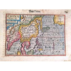
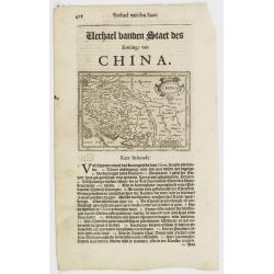
China Regio Asie / Von China.
An attractive example of Barent Langenes's map of China and neighbouring countries, which first appeared in the 1598 edition of Langenes's 'Caert-Thresoor'. This example ...
Date: Amsterdam, 1612
Selling price: ????
Please login to see price!
Sold in 2020
Chinae, olim Sinarum Regionis, nova descriptio. Auctore Ludovico Georgio.
The first map of China ever to appear in a Western atlas, west to the top. When this map appeared, it was by far the most accurate one of China.Japan is shown on a curiou...
Date: Antwerp, 1598/1613
Selling price: ????
Please login to see price!
Sold in 2011
Chinae, olim Sinarum Regionis, nova descriptio. Auctore Ludovico Georgio.
The first map of China ever to appear in a Western atlas, west to the top. When this map appeared, it was by far the most accurate one of China.Japan is shown on a curiou...
Date: Antwerp, 1598/1613
Selling price: ????
Please login to see price!
Sold in 2012
China.
Important map of China. Besides China, the map depicts Korea as an elongated island and Japan from the Teixeira model of 1595
Date: Amsterdam, 1619
Selling price: ????
Please login to see price!
Sold in 2017
China.
Small map illustrating China with the Great Wall and Korea as an island, surrounded by text in Dutch.Nicolaes de Clerck (de Klerc) was active as engraver and publisher in...
Date: Amsterdam, Cloppenburch, 1621
Selling price: ????
Please login to see price!
Sold
China.
A splendid map of China heightened in gold. Besides China, the map depicts Korea as an elongated island and Japan from the Teixeira model of 1595. Decorated with strapwor...
Date: Amsterdam, 1623
Selling price: ????
Please login to see price!
Sold in 2016
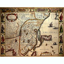
The kingdome of China..
Speed?s splendidly embellished map of China and Japan. The upper borders illustrate the cities of Macao and Quinzay (Hangchow). Further images depict the curious Chinese ...
Date: London 1626
Selling price: ????
Please login to see price!
Sold
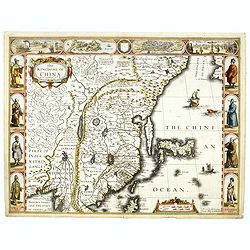
The Kingdome of China.
A most sought-after map of China. Decorative border vignettes including views of the cities of Quinzay and Macao along the top border with the wheeled wind machines and p...
Date: London. Bassett & Chiswell, 1626
Selling price: ????
Please login to see price!
Sold in 2016
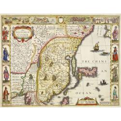
The Kingdome of China.
A most sought-after map of China. Decorative border vignettes including views of the cities of Quinzay and Macao along the top border with the wheeled wind machines and p...
Date: London, G. Humble, 1626
Selling price: ????
Please login to see price!
Sold in 2016
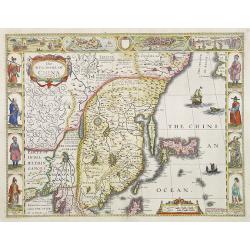
The Kingdome of China.
A most sought-after map of China. Decorative border vignettes including views of the cities of Quinzay and Macao along the top border with the wheeled wind machines and p...
Date: London 1627
Selling price: ????
Please login to see price!
Sold
The Kingdome of China.
A most sought-after map of China. Decorative border vignettes including views of the cities of Quinzay and Macao along the top border with the wheeled wind machines and p...
Date: London, 1627
Selling price: ????
Please login to see price!
Sold in 2008
China.
Important map of China. Besides China, the map depicts Korea as an elongated island and Japan from the Teixeira model of 1595. Decorated with strapwork cartouches, a Euro...
Date: Amsterdam 1630
Selling price: ????
Please login to see price!
Sold
China.
An important map of China. Besides China, the map depicts Korea as an elongated island and Japan from the Teixeira model of 1595. Decorated with strapwork cartouches, a E...
Date: Amsterdam, 1630
Selling price: ????
Please login to see price!
Sold in 2008
China.
Map of China from the rare Cloppenburg edition slightly larger format and more scarce edition of the Mercator/Hondius "Atlas Minor". Korea is shown as an island...
Date: Amsterdam, 1630
Selling price: ????
Please login to see price!
Sold in 2018
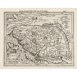
China / Le Royaume de la Chine.
An attractive miniature map of China from a French edition of the 'Atlas Minor' by Jansson.
Date: Amsterdam, 1630
Selling price: ????
Please login to see price!
Sold in 2020
China.
Important map of China. Besides China, the map depicts Korea as an elongated island and Japan from the Teixeira model of 1595. Decorated with strapwork cartouches, a Euro...
Date: Amsterdam, 1633
Selling price: ????
Please login to see price!
Sold in 2013
China.
Important map of China. Besides China, the map depicts Korea as an elongated island and Japan from the Teixeira model of 1595. Decorated with strap work cartouches, a Eur...
Date: Amsterdam, 1633
Selling price: ????
Please login to see price!
Sold in 2015
China.
An attractive map of China from the 1634 Latin edition of Mercator's Atlas minor, published by Jan Janssonius. During the production of Mercator's large-format atlas, Hon...
Date: Amsterdam, 1634
Selling price: ????
Please login to see price!
Sold in 2020
China.
Scarce English version of Hondius’ smaller map of China set in a page of text.
Date: London, c. 1635
Selling price: ????
Please login to see price!
Sold in 2012
China Veteribus Sinarum Regio.
This was the first of Blaeu's maps of China. In 1655 he was to publish the famous map of Father Martini, with many of the earlier inaccuracies present on this map correct...
Date: Amsterdam, 1638
Selling price: ????
Please login to see price!
Sold in 2010
China Veteribus Sinarum Regio.
This was the first of Blaeu's maps of China. In 1655 he was to publish the famous map of Father Martini, with many of the earlier inaccuracies present on this map correct...
Date: Paris / Amsterdam, 1638
Selling price: ????
Please login to see price!
Sold in 2013
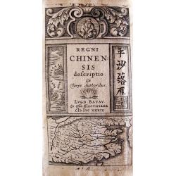
Regni Chinensis Descriptio.
Lugduni Batavorum (Leiden), ex off, Elzeviriana, in-24o, (viii) + 365 pp + (9) nn pp (index), with decorative engraved title depicting a map of China and 2 woodcut costum...
Date: Leiden, Elzevier,1639
Selling price: ????
Please login to see price!
Sold in 2010
China Veteribus Sinarum Regio nunc Incolis Tame dicta.
Elegant 17th century map of China and Japan. The map is closely modelled on Janssonius' map of 1633. The detail includes the eastern part of China (bounded in the west by...
Date: Amsterdam 1640
Selling price: ????
Please login to see price!
Sold
China Veteribus Sinarum Regio.
Based on Jesuit surveys, the map represents the next major revision in the cartography of China after Ortelius' 1584 map. Korea, however, is still an island, and Japan co...
Date: Amsterdam 1640
Selling price: ????
Please login to see price!
Sold
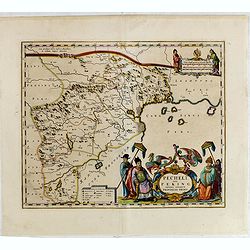
Pecheli sive Peking imperii sinarum provincia prima.
The map of the province of Peking from Joan Blaeu's Novus Atlas Sinensis , the first atlas of china with maps by the hand of the Italian Jesuit Martino Martini. A beautif...
Date: Amsterdam, 1640
Selling price: ????
Please login to see price!
Sold
Pecheli sive Peking imperii sinarum provincia prima.
The map of the province of Peking from Joan Blaeu's Novus Atlas Sinensis , the first atlas of china with maps by the hand of the Italian Jesuit Martino Martini. A beautif...
Date: Amsterdam, 1640
Selling price: ????
Please login to see price!
Sold in 2013
Pecheli sive Peking imperii sinarum provincia prima.
The map of the province of Peking from Joan Blaeu's Novus Atlas Sinensis , the first atlas of china with maps by the hand of the Italian Jesuit Martino Martini. A beautif...
Date: Amsterdam, 1640
Selling price: ????
Please login to see price!
Sold in 2015
China Veteribus Sinarum Regio nunc Incolis Tame dicta
Willem and Johan Blaeu's map of China, with Japan and Korea. With the Great Wall forming the northern boundary of China and the fictitious lake Chiamay.Title in a cartouc...
Date: Amsterdam, ca. 1640
Selling price: ????
Please login to see price!
Sold in 2023
China.
Detailed miniature map of the eastern part of China, from a German text edition of his Atlas Minor. Engraved by Petrus Kaerius.
Date: Amsterdam (1628) 1648
Selling price: ????
Please login to see price!
Sold
China veteribus Sinarum Regio nuc incolis Tame dicta.
A very fine example of this classic 17th century map, and Blaeu’s first of China, in attractive strong original color. The map further shows the whole of Japan, the 'is...
Date: Amsterdam, 1650
Selling price: ????
Please login to see price!
Sold in 2020
Royaume de la Chine.
Map of the eastern part of China, with Korea shown as an island, from the first edition of the atlas L'Asie en plusieurs cartes nouvelles, et exactes & en divers trai...
Date: Paris, 1652
Selling price: ????
Please login to see price!
Sold in 2014
China Veteribus Sinarum Regio.
This was the first of Blaeu's maps of China. In 1655 he was to publish the famous map of Father Martini, with many of the earlier inaccuracies present on this map correct...
Date: Amsterdam, 1653
Selling price: ????
Please login to see price!
Sold in 2021
China Veteribus Sinarum Regio.
This was the first of Blaeu's maps of China. In 1655 he was to publish the famous map of Father Martini, with many of the earlier inaccuracies present on this map correct...
Date: Amsterdam, 1653
Selling price: ????
Please login to see price!
Sold in 2016
Xantung, sinarum imperii provincia quarta.
Map of the province of Shandong.From the Blaeu\'s \"Novus Atlas Sinensis\". Ornated with the typical high decorative ornated title cartouche together with an mi...
Date: Amsterdam, 1655
Selling price: ????
Please login to see price!
Sold in 2008
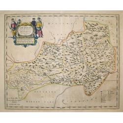
Quangsi, Sinarum Imperii Provinciae Decimatertia.
A map of a part of China published by J. Blaeu, in the second landmark in the European mapping of China "the Atlas Sinensis" in 1655.
Date: Amsterdam, 1655
Selling price: ????
Please login to see price!
Sold in 2009
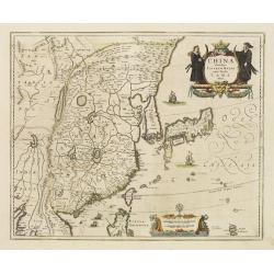
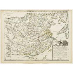
Imperii Sinarum.
A very decorative map of China. In the ocean, six vessels are depicted. Title cartouche on the lower left hand corner.Joannes van Loon was an accomplished mathematician a...
Date: Amsterdam, 1655
Selling price: ????
Please login to see price!
Sold in 2009
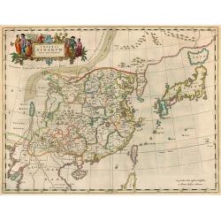
Imperii Sinarum Nova Descriptio
A important general map of China, Korea and Japan, published by Joan Blaeu in the Jesuit Martino Martini's Atlas Sinensis , the first western atlas of China. Incorporates...
Date: Amsterdam, 1655
Selling price: ????
Please login to see price!
Sold in 2010

Xensi Imperii Sinarum provincia tertia.
Based on the remarkably accurate compilations of the Jesuit Father Martino Martini during his travels between 1643 and 1650, this map of the Xensi (Shaanxi) province feat...
Date: Amsterdam, 1655
Selling price: ????
Please login to see price!
Sold in 2015
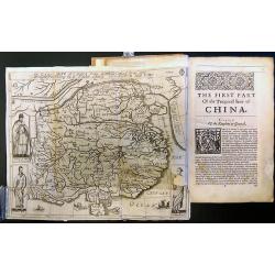
The History of That Great and Renowned Monarchy of China.
An important account of China, written by the Portuguese Jesuit Alvarez de Semedo (1586-1658), who was stationed in China from 1613 to 1637. On his return to Europe, Seme...
Date: London, 1655
Selling price: ????
Please login to see price!
Sold in 2017
Imperii Sinarum Nova Descriptio.
A superb map of the Chinese Empire based on the compilation of the Jesuit Father Martino Martini who travelled through the region between 1643 and 1650.This was a period ...
Date: Amsterdam, 1655
Selling price: ????
Please login to see price!
Sold in 2017
Xantung Sinarum Imperii Provincia Quarta.
A map of the province of Shandong, China. Many larger cities are named including Tungchang, Cinan, Yencheu. Laicheu and Leaochang. At the upper right side is an engrave...
Date: Amsterdam, 1655
Selling price: ????
Please login to see price!
Sold in 2018
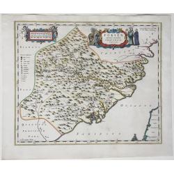
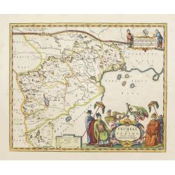
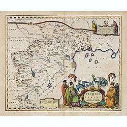
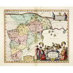
Fokien, Imperii Sinarum Provincia Undecima.
A map of the Chinese province of Fokien, by Joan Blaeu. Title in a cartouche with Chinese figures at top centre. At top left a cartouche with putti containing mileage sca...
Date: Amsterdam, 1655
Selling price: ????
Please login to see price!
Sold in 2020
La Chine Royaume. . .
An important and attractive French map of the whole of China, the northern tip of the Philippines, with a strangely curved Korea and an under-sized Taiwan here called &qu...
Date: Paris, 1656
Selling price: ????
Please login to see price!
Sold in 2016
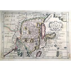
La Chine.
A very uncommon map of China by Picart. With rivers, mountains, lakes and many place names given.
Date: Paris, ca. 1657
Selling price: ????
Please login to see price!
Sold in 2021
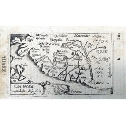
Chinae Compendiosa Descriptio.
A scarce early map of China with beautiful geographic detail. Published in "Historiae Universalis Auctarium". Page marked "XXVIII".
Date: Ulm, 1658
Selling price: ????
Please login to see price!
Sold in 2020
