Browse Listings in Asia
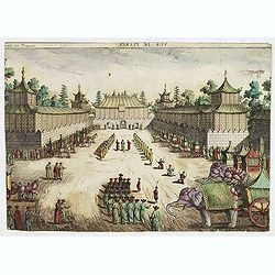
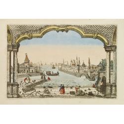
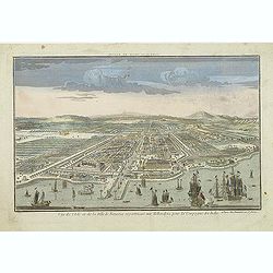
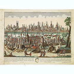
Vue de Peckin. (Peking)
So-called optical print of Peking published by "Collection des prospects" and engraved by G. B. Leizelt. Title is engraved mirror-imaged along the top. Lower ti...
Date: Augsburg, 1778
Selling price: ????
Please login to see price!
Sold in 2012
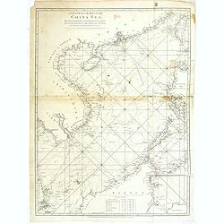
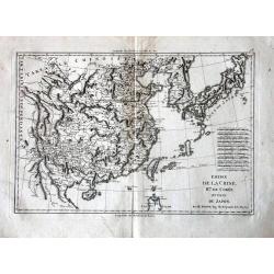
A general chart of the China Sea : drawn from the journals of the European navigators, particularly from those collected by Capt. Hayter.
A scarce and detailed showing China Sea with Taiwan, western part of the Philippines, northern part of Borneo and the coast of South China with Cochinchina. Latitude and...
Date: London, 1778
Selling price: ????
Please login to see price!
Sold in 2013
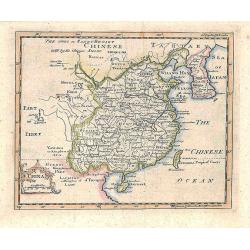
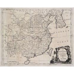
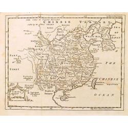
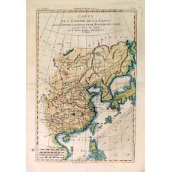
China.
Prepared by Thomas Jefferys and Thomas Phinn for Salmon's New Universal Geographical Grammar.
Date: Edinburgh, 1778
Selling price: ????
Please login to see price!
Sold in 2018
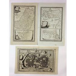
![The country Coromandel from the Coleroon to Cape Comorin. . . [with] The carnatic from the Pennar to the Coleroon. .](/uploads/cache/40457-250x250.jpg)
The country Coromandel from the Coleroon to Cape Comorin. . . [with] The carnatic from the Pennar to the Coleroon. .
Coromandel from the Coleroon to Cape Comorin. Elegant map in two sheets compiled for the East-India Company. In lower right margin : Writing by W. Harrison.
Date: London, 1778
Selling price: ????
Please login to see price!
Sold in 2020
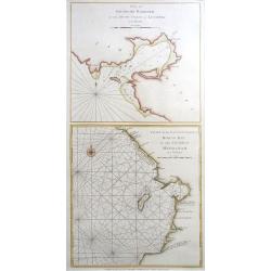
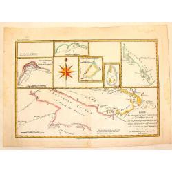
Plan of Solsogon Harbour / Chart on the Eastern Coast of Bongo Bay (Mindanao).
A nice copper engraving, with 2 Philippine sea charts on one sheet, published by Laurie & Whittle in London; pl. 125. With the usual sand banks, depth soundings, rhum...
Date: London, 1794-1778
Selling price: ????
Please login to see price!
Sold in 2020
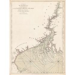
A Chart of the Braces at the Entrance of the Ganges or River...
A Chart of the Braces at the Entrance of the Ganges or River of Hughly with the Course of that River up to the Town of Hughly. Improved from Mr. d’Anville’s Chart of ...
Date: London, 1778
Selling price: ????
Please login to see price!
Sold in 2023
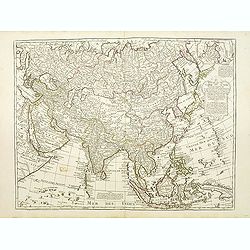
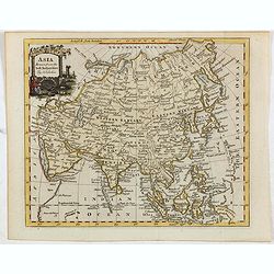
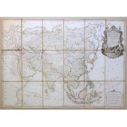
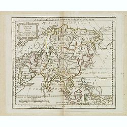
Carte d'Asie. . .
Detailed map of Asia with an inset map of Siberia and the east coast of America with a "Nord-Ouest" passage.The map is of interest for the use of East Sea, the ...
Date: Paris, 1779
Selling price: ????
Please login to see price!
Sold
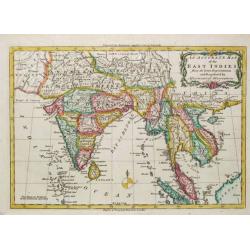
An Accurate Map of the East Indies.
A detailed map of India and Indo China from Middleton's "Complete System of Geography".
Date: London, 1779
Selling price: ????
Please login to see price!
Sold
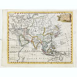
Carte d'Asie.
This is Guillaume de l’Isles third map of the continent of Asia, showing the improvements in knowledge made during the first quarter of the 18th century. Arabia has bee...
Date: Paris 1779
Selling price: ????
Please login to see price!
Sold in 2013
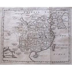
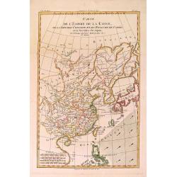
An Accurate Map of the Empire of China.
A highly detailed map of China and Korea including both Hainan and Formosa (Taiwan). An ornate scenic title cartouche completes the composition. The maps border shows the...
Date: London, 1779
Selling price: ????
Please login to see price!
Sold in 2015
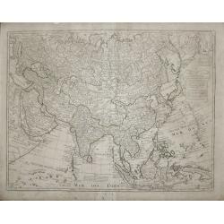
Asia drawn from the best authorities by T. Kitchin.
Map of Asia from William Guthrie, "A new geographical, historical, and commercial grammar... with a correct set of maps, engraved by Mr. Kitchin... The sixth edition...
Date: London, 1779
Selling price: ????
Please login to see price!
Sold in 2015
Asia T. Jefferys sculp
Map of Asia from William Guthrie, "The modern gazetteer: or, A short view of the several nations of the world. Absolutely necessary for rendering the public news, an...
Date: London, 1779
Selling price: ????
Please login to see price!
Sold in 2015
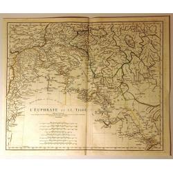
L'Euphrate et le Tigre
Detailed map of present day Syria and Iraq. It shows adjacent lands of Anatolia, and Iran. Some of the names of provinces and tribes are: Alghezira, Kurdistan, Chuzestan,...
Date: Paris, 1779
Selling price: ????
Please login to see price!
Sold in 2020
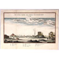
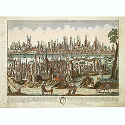
Vue D'Une Partie des Ruines de Pondichery en 1769.
Fine city view of Pondicherry India by Guillaume le Gentil. It was engraved by Gardette in 1769. It has a key at the bottom identifying important buildings in the city.
Date: Paris , 1779
Selling price: ????
Please login to see price!
Sold in 2018
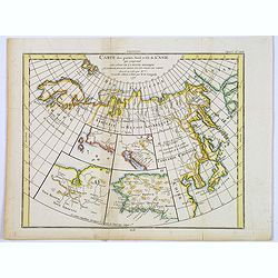
Carte des parties Nord et Est de L'Asie. . .
Five maps on one sheet, showing the Northern Russian territories in Europe and Asia, including the western coastline from Siberia, with Japan and Korea with the island of...
Date: Paris, 1779
Selling price: ????
Please login to see price!
Sold in 2017
![[Untitled] Sea chart of Ceylon and Southern India.](/uploads/cache/44286-250x250.jpg)
[Untitled] Sea chart of Ceylon and Southern India.
A scarce separately published English Sea Chart of the south coast of India, the island of Ceylon, with inset maps of Gula Bay (Galle) Sri Lanka, Tutocarine Bay (Tuticori...
Date: London, 1779
Selling price: ????
Please login to see price!
Sold in 2019
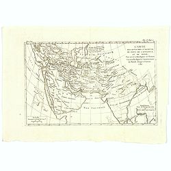
Carte de l'Asie divisée en ses principaux etats, projettée et assujettie au ciel par M. Bonne, Hydrographe du Roi.
A very rare and large 18th century map of the Asian continent. This map can only be found in a few institutional collections. An impressive and artistic cartouche.
Date: Paris, 1779
Selling price: ????
Please login to see price!
Sold in 2020
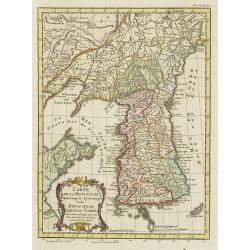
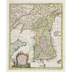
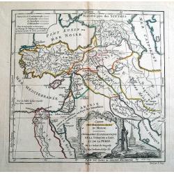
Carte de la Province de Quantong ou Lyau-tong et du Royaume de Kau-Li ou Coree . . .
Map of Korea. The language on the map is Dutch and French. The notation at the bottom indicates that the prime meridian is set at Ferro Island, otherwise known as El Hier...
Date: Paris, 1780
Selling price: ????
Please login to see price!
Sold
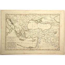
Destroit des Dardanelles..
Decorative view of Istanbul and 'Hellespont'. With a numbered key (1-20) in bottom. Profile view of Istanbul and the Marmora Sea on the horizon.
Date: Paris 1780
Selling price: ????
Please login to see price!
Sold
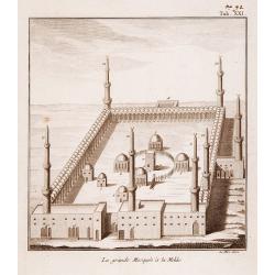
La Grande Mosquee a la Mekke.
A very fine view of the temple of Mecca.
Date: France, ca. 1780
Selling price: ????
Please login to see price!
Sold
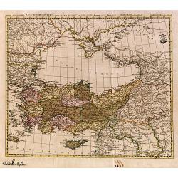
Mappa geographica Asiae Minoris Antiquae..
A detailed of Turkey, Black Sea and Cyprus.
Date: Germany c.1780
Selling price: ????
Please login to see price!
Sold
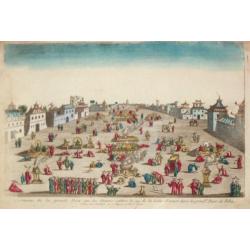
Ceremonie de la grande Feste que les Chinois celebre le 24 de la Lune d'Aoust dans la principale Place de Pekin.
An optical view of festivities on the 24th of August in Bejing.
Date: Paris, c. 1780
Selling price: ????
Please login to see price!
Sold
Vue du Port et de la Ville de L'Amekk dans Larbie..
So called optical print of Mekka. In lower part of the print the title: Vue du Port et de la Ville de L'Amekk dans Larbie heureuse a 5 lieues de la Mar Rouge .Rare.In the...
Date: Paris, ca 1780
Selling price: ????
Please login to see price!
Sold
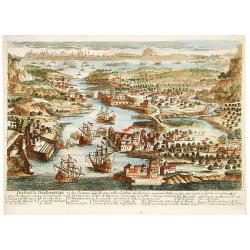
Veue de Constantinople.
Naïve panoramic view of Istanbul.
Date: Paris 1780
Selling price: ????
Please login to see price!
Sold
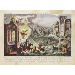
Vue de la Ville Bethlehem. . .
So-called optical print of the city Bethlehem in Israel, showing an angel announcing the birth of Jesus Christ. One of the well-known and earliest publishers of optical p...
Date: Paris, 1780
Selling price: ????
Please login to see price!
Sold in 2014
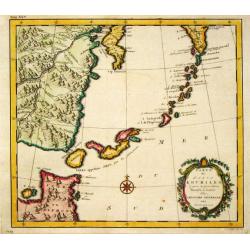
Carte des Isles Kouriles.
An attractive and unusual map of the Kuriles Islands and the northern coast of Hokkaido. The map includes numerous inaccuracies and fanciful names for a number of the isl...
Date: Amsterdam, 1780
Selling price: ????
Please login to see price!
Sold in 2011
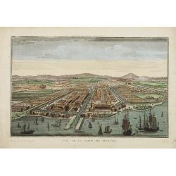
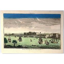
Vue de la ville de Batavia.
A so-called optical print showing a bird's eye view of Batavia, Java (now Djakarta, Indonesia), the headquarters of the V.O.C. in Indonesia. In the foreground many Dutch ...
Date: Paris, 1780
Selling price: ????
Please login to see price!
Sold in 2009
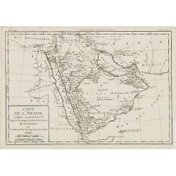
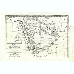
Carte de L'Arabie, rédigée en grande partie d'après le voyge récent et les Cartes de M. Niebuhr par le Sr. Brion de la Tour. . .
Giving good detail of the Arabian peninsula. From "Histoire Universel" by Louis Brion de la Tour.
Date: Paris, 1780
Selling price: ????
Please login to see price!
Sold
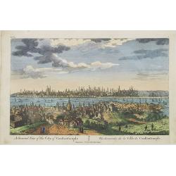
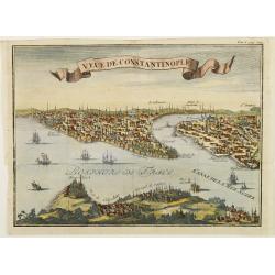
A General View of the City of Constantinople / Vue Générale de la Ville de Constantinople.
A panoramic view of Constantinople. Printed for F. West 83 Fleet Street, London.
Date: London, c.1780
Selling price: ????
Please login to see price!
Sold in 2009
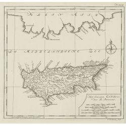
Het eiland cyprus door R.Pococke.
Rare map of Cyprus from a Dutch edition of ""Description Of The East And Some Other Countries" by R. Pococke. "Beschryving van het Oosten enz. Door de...
Date: Amsterdam/ Rotterdam, 1780
Selling price: ????
Please login to see price!
Sold in 2010
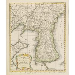
Carte de la Province de Quantong ou Lyau-tong et du Royaume de Kau-Li ou Corée . . .
Map of Korea. The language on the map is Dutch and French. The notation at the bottom indicates that the prime meridian is set at Ferro Island, otherwise known as El Hier...
Date: Paris, 1780
Selling price: ????
Please login to see price!
Sold in 2010
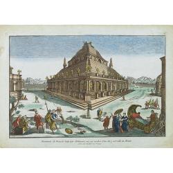
Monument de Mausoli batis par Arthemise mis au nombre d'une des 7 merveille du Monde.
Optical print from the series of 7 engravings "Seven wonders of the ancient world". Showing the Temple of Artemis at Ephesus.Located in Bodrum, about 50 km sout...
Date: Paris, 1780
Selling price: ????
Please login to see price!
Sold in 2013
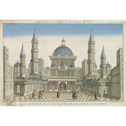
Vue du superbe Temple de Ste Sophie aujourd'huy Mosquée principale à Constantinople.
A fanciful depiction of the Aya Sofya in Istanbul. In the eighteenth and nineteenth centuries there were many popular specialty establishments in Paris, Augsburg and Lond...
Date: Paris, 1780
Selling price: ????
Please login to see price!
Sold in 2013
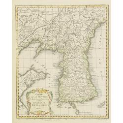
Carte de la Province de Quantong ou Lyau-tong et du Royaume de Kau-Li ou Corée . . .
Map of Korea. The map is of interest for the use of East Sea, the sea between Korea and Japan, here called "Mer de Corée Meer von Korea." Decorative title car...
Date: Paris, 1780
Selling price: ????
Please login to see price!
Sold
China.
Decorative map by the noted English cartographer Thomas Jeffreys, Geographer to George III and the Prince of Wales.
Date: London, c. 1780
Selling price: ????
Please login to see price!
Sold in 2012
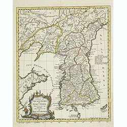
A map of Quan-Tong or Lea-Tonge province, and the kingdom of Kau-Li or Corea . . .
Detailed map of Korea, Liaodong, and the tip of Shandong Province prepared by Thomas Kitchin for Thomas Salmon's Universal Traveller, based on D'Anville's landmark map of...
Date: London, 1780
Selling price: ????
Please login to see price!
Sold
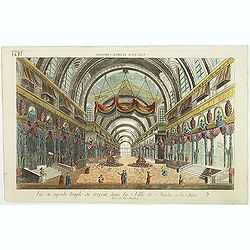
Vue d'un Temple Chinois.
So called optical print showing the interior of a Chinese temple. In the eighteenth and nineteenth centuries there were many popular specialty establishments in Paris, Au...
Date: Paris, 1780
Selling price: ????
Please login to see price!
Sold in 2017
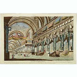
Vue du superbe Temple du Serpent dans la Ville de Juida a la Chine.
Uncommon, so-called optical print of a imaginary interior of a Chinese temple, decorated with vases and two large Buddha's in the center. In the eighteenth and nineteenth...
Date: Paris, 1780
Selling price: ????
Please login to see price!
Sold in 2017
Vue de l\'Isle et de la ville Batavia appartenant aux Hollandois. . .
So called optical print of present-day Jakarta. Published by the well-known Paris publisher Daumont after a design of Jan van Ryne in 1754. Van Ryne was born in the Nethe...
Date: Paris, c.1780
Selling price: ????
Please login to see price!
Sold in 2011
Constantinopolis.
Beautiful optical printof Constantinople, the capital of the Ottoman Empire between 1453 and 1922. It was officially renamed to its modern Turkish name Istanbul in 1930, ...
Date: Augsburg, 1780
Selling price: ????
Please login to see price!
Sold in 2011
A map of Quan-Tong or Lea-Tonge province, and the kingdom of Kau-Li or Corea . . .
Detailed map of Korea, Liaodong, and the tip of Shandong Province prepared by Thomas Kitchin for Thomas Salmon's Universal Traveler, based on D'Anville's landmark map of ...
Date: London, 1780
Selling price: ????
Please login to see price!
Sold
Empire de la Chine, Rme. de Coree, ad Isles Du Japon
Attractive map of China that includes an impressive 11 different scales.
Date: Paris, c. 1780
Selling price: ????
Please login to see price!
Sold
Constantinopolis.
Beautiful optical printof Constantinople, the capital of the Ottoman Empire between 1453 and 1922. It was officially renamed to its modern Turkish name Istanbul in 1930, ...
Date: Augsburg, 1780
Selling price: ????
Please login to see price!
Sold in 2012
CARTE DES PREMIERS AGES DU MONDE
Beautiful ancient map, showing the eastern Mediterranean and the Near East. Includes parts of the present countries of Cyprus, Turkey, Russia, Black Sea, Caspian Sea, Arm...
Date: Paris, 1780
Selling price: ????
Please login to see price!
Sold in 2014
China.
Decorative map by the noted English cartographer Thomas Jeffreys, Geographer to George III and the Prince of Wales.
Date: London, c. 1780
Selling price: ????
Please login to see price!
Sold in 2012
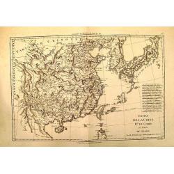
Carte de L'Empire de la Chine. . .
Nice copper-engraved map of China, Korea and Japan. Most of the topographical detail is limited to China. Small arrows indicate the trade winds. The map bears four distan...
Date: Paris, c. 1780
Selling price: ????
Please login to see price!
Sold in 2012
Carte de L'Empire de la Chine . . .
Nice copper-engraved map of China, Korea and Japan. Most of the topographical detail is limited to China. Small arrows indicate the trade winds. The map bears four distan...
Date: Paris, c. 1780
Selling price: ????
Please login to see price!
Sold in 2013
Carte de l'Asie. . .
Scarce map of Asia prepared by de la Fosse and published by L.J. Mondhare for his Atlas Général a l'usage des colleges et maisons d'education.. Louis Joseph Mondhare wa...
Date: Paris, 1780
Selling price: ????
Please login to see price!
Sold in 2016
![Fille tatare de Katchin par devant. [together with] Fille tatare de Katchin par derriere.](/uploads/cache/32992-250x250.jpg)
Fille tatare de Katchin par devant. [together with] Fille tatare de Katchin par derriere.
Uncommon copper engraved costume plate from Johann Gottlieb Georgi "Beschreibung aller Nationen des russischen Reichs" (1776), the work stands out for the hand-...
Date: St. Petersbourg, C.G. Müller, 1776-1780
Selling price: ????
Please login to see price!
Sold in 2020
![Feme Tattare de Casan par devant. [together with] Feme Tattare de Casan par derriere.](/uploads/cache/32994-250x250.jpg)
Feme Tattare de Casan par devant. [together with] Feme Tattare de Casan par derriere.
Uncommon copper engraved costume plate from Johann Gottlieb Georgi "Beschreibung aller Nationen des russischen Reichs" (1776), the work stands out for the hand-...
Date: St. Petersbourg, C.G. Müller, 1776-1780
Selling price: ????
Please login to see price!
Sold in 2013
Carte des Decouvertes du Capital Carteret dans La Nouvelle bretagne.
Detailed copperplate map of Papua New Guinea and the regions to the west including New Ireland, Sable Banks, the Celebes and Southern Mindanao. BONNE, RIGOBERT (1729-179...
Date: Paris, 1780
Selling price: ????
Please login to see price!
Sold in 2015

Tattare de Kasan.
Uncommon copper-engraved costume plate from Johann Gottlieb Georgi "Beschreibung aller Nationen des russischen Reichs" (1776), the work stands out for the hand-...
Date: St. Petersbourg, C.G. Müller, 1776-1780
Selling price: ????
Please login to see price!
Sold in 2017
Empire de la Chine, Rme. de Coree, ad Isles Du Japon.
Very attractive map of China that includes 11 different scales.
Date: Paris, c. 1780
Selling price: ????
Please login to see price!
Sold in 2018
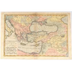
La Turquie d'Europe et Celle D'Asie.
A fine example of Rigobert Bonne and Guilleme Raynal's 1780 map of Turkey in Europe and Asia. This map of the Ottoman Empire includes the areas stretching from Italy, Hun...
Date: Paris, c1780
Selling price: ????
Please login to see price!
Sold in 2016
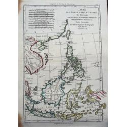
Carte des Indes en deçà et au delà du Gange...
Detailed 18th century map of the Philippines, Borneo, and parts of Indonesia from the Strait of Singapore to New Guinea. Includes also Formosa (Taiwan) and Hainan. A deta...
Date: Paris, ca. 1780
Selling price: ????
Please login to see price!
Sold in 2015
Carte des Royoumes d'Armenie, de Pont, de Cappadoce et de Medie
Fine copper engraved engraving featuring the Middle East and Asia by Brion de la Tour, and published in "HISTOIRE UNIVERSELL" by Chez Moutard.
Date: Paris, 1780
Selling price: ????
Please login to see price!
Sold in 2015
Carte du Kamtchatka Dressee et Gravee par Laurent.
A striking copper engraved map of the peninsula of Kamtchatka in Eastern Russia, with excellent detail of the topography. Numerous roads and settlements are located. The ...
Date: Paris, 1780
Selling price: ????
Please login to see price!
Sold in 2016
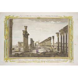
‘A General Perspective View of the Ruins of the celebrated Temple of Palmira in Arabia'
Engraved by John Lodge, and published in Millar's New Complete & Universal System of Geography.This engraving shows the ruins of the 2,000 year old Temple of Palmyra,...
Date: London, 1780
Selling price: ????
Please login to see price!
Sold in 2016
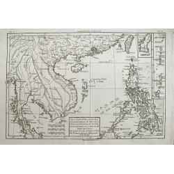
Les Isles Philippines, celle de Formose, le sud de la Chine,...
A very interesting map of the South China Sea and the Philippines. Highly detailed with numerous places and islands named.Extends from Pegu and Thailand to Taiwan, and so...
Date: Paris, c1780
Selling price: ????
Please login to see price!
Sold in 2016
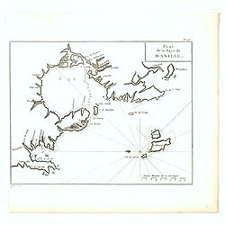
Plan de la Baye de Manille.
Detailed plan of Manila Bay engraved by Jean Lattré after Anson's key plan of the Bay of Manila. With a compass rose and soundings in the Bay.
Date: Paris, c.1780
Selling price: ????
Please login to see price!
Sold in 2016
Vue de la Pondichery dans les Indes Orientales
Pondicherry is the capital city of Indian union territory of Puducherry. Pondicherry is situated in Puducherry district of the union territory in India. The vue was produ...
Date: Paris, 1780
Carte des Royaumes d'Armenie. de Pont, de Cappadoce, et de Medie...
An ancient map by the French cartographer Rigobert Bonne, showing the Arabian peninsular, the eastern Mediterranean, Persia, India, and the countries surrounding the Casp...
Date: Paris, 1780
Selling price: ????
Please login to see price!
Sold in 2017
Set of Three Bible Engravings by Condor.
A set of 3 bible copper engravings from "Mr. Priestley's Evangelical Family Bible". Two of the maps have two maps on one sheet so there are a total of four maps...
Date: London, ca. 1780
Selling price: ????
Please login to see price!
Sold in 2017
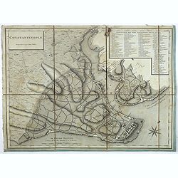
Constantinople.
Plan of Constantinople engraved by Tardieu, decorated with a rose of the winds. The names on the plan are written in Turkish, the key (1 - 86) in French.
Date: Paris, 1780
Selling price: ????
Please login to see price!
Sold in 2023
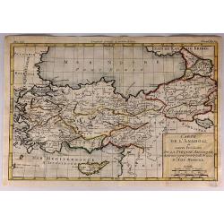
Carte de L'Anadoli et Autres Provinces de la Turquie Asiatique...
A striking, copper engraved map of Anatolia. The map covers Turkey, Armenia, Cyprus, a bit of Georgia, the northern tip of Syria, and the coast of Romania. The map provid...
Date: Paris, 1780
Selling price: ????
Please login to see price!
Sold in 2017
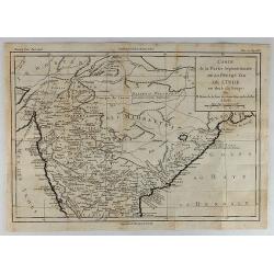
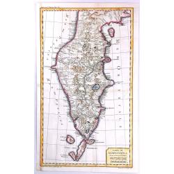
Carte de la Partie Septentrionale de la Presqu'ile de L'Inde...
Striking map of central and northern India showing rivers, mountains, towns and cities, including Bombay. Beneath the title cartouche, the Bouches du Gange ("Mouth...
Date: Paris, 1780
Selling price: ????
Please login to see price!
Sold in 2018
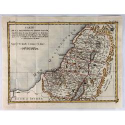
Carte de la Palestine ou Terre Sainte.
A pleasant map of the Holy Land from Sidon to Gaza and inland to the Arabian Desert. The map is divided into the Tweve Tribes and a key identifies royal villages and Levi...
Date: Paris, 1780
Selling price: ????
Please login to see price!
Sold in 2019
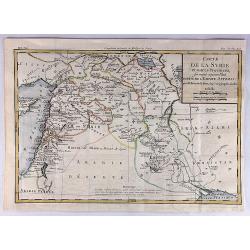
Carte de la Syrie et Autres Provinces Formant Aujourd'hui Partie de L'Empire Ottoman.
A fine map of Syria and other regions including; Roum, Irakarabia, Khosistan, Armemia, Kurdistan and Palestine. Also shown is most of the island of Cyprus. Louis Brion de...
Date: Paris, 1780
Selling price: ????
Please login to see price!
Sold in 2020
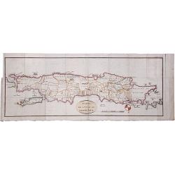
CARTE DE L'ISLE DE GRAND JAVA.
A scarce copperplate hand colored map of the island of Java. It shows the island upside down with the north to the bottom. Divided by regions with names of territories, s...
Date: Paris, ca. 1780
Selling price: ????
Please login to see price!
Sold in 2020
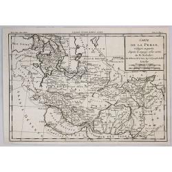
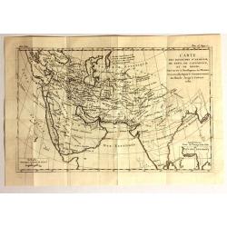
Carte de la Perse Redigee en Partie d'Apres le Voyage et les Cartes de M. Niebhr.
An interesting detailed map of the region stretching from the Caucasus through Afghanistan and the Arabian Desert to the Indus River. By Brion de la Tour in Paris in 1780...
Date: Paris, 1780
Selling price: ????
Please login to see price!
Sold in 2018
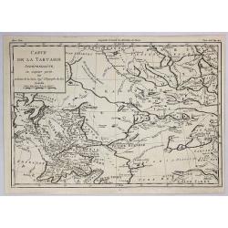
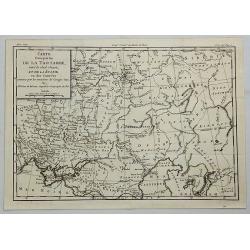
Carte de la Tartarie Independante. . .
An interesting detailed map of the region stretching from Khorasan to Grand Tibet and north to Siberia. By Brion de la Tour in Paris in 1780. From Historie Universale.Lou...
Date: Paris, 1780
Selling price: ????
Please login to see price!
Sold in 2019
Carte de L'Arabie, rédigée en grande partie d'après le voyge récent et les Cartes de M. Niebuhr par le Sr. Brion de la Tour. . .
Map giving good detail of the Arabian peninsula. From "Histoire Universel" by Louis Brion de la Tour.
Date: Paris, 1780
Selling price: ????
Please login to see price!
Sold in 2021
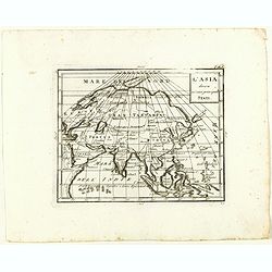
L'Asia divisa ne' suoi principali stati.
Rare map of Asia, from "Atlante Novissimo ad uso Dei Giovani Studiosi Contenuto In Carte XXVII.", published by Giovanni Zempel in Rome, ca. 1780.The map is base...
Date: Rome, 1780
Selling price: ????
Please login to see price!
Sold in 2018
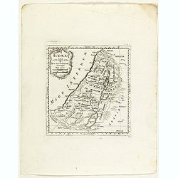
Iudaea.
Rare map of Holy Land, from "Atlante Novissimo ad uso Dei Giovani Studiosi Contenuto In Carte XXVII.", published by Giovanni Zempel in Rome, ca. 1780.The map is...
Date: Rome, 1780
Selling price: ????
Please login to see price!
Sold in 2018
Carte d'Une Partie de la Tartarie Vers le sud Ouest et de la Russie ou des Contrees & Carte de la PARTIE Meridionale de la Tartarie.
[TWO MAPS] A striking pair of matching maps of Tartary covering the area (a) between Turkey and Kirgisi and from Siberia to the Caspian sea, and (b) the area between Indo...
Date: Paris, 1780
Selling price: ????
Please login to see price!
Sold in 2021
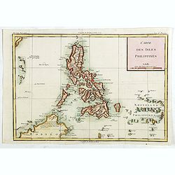
Carte des Isles Philippines.
Detailed map of Philippines, published by Louis Brion de la Tour. From the 'Histoire Universel'.More about maps of the Philippines. [+]
Date: Paris, c.1780
Selling price: ????
Please login to see price!
Sold in 2019
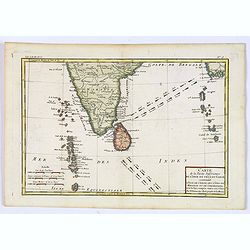
![[Untitled] English Sea Chart.](/uploads/cache/42898-250x250.jpg)
[Untitled] English Sea Chart.
A large, English Sea Chart of southern India, the Maldives (and other) Islands, and the island of 'Zeloan' (Sri Lanka). The interiors are almost bare of any information w...
Date: Anon, ca 1780
Selling price: ????
Please login to see price!
Sold in 2018
Carte de la Partie Inferieure de l'Inde en Deca du Gange. . .
A late eighteenth century map of southern India by the French cartographer Rigobert Bonne. Shows the southern coasts of Malabar and Coromandel. Map extent is from the Dec...
Date: Paris, 1780
Selling price: ????
Please login to see price!
Sold in 2020
La Turquie d'europe et Celle d'Asie.
Fine example of Bonne’s 1780 map of Turkey in Europe and Asia. This map of the Ottoman Empire includes the areas stretching from Italy, Hungary, and modern day Austria ...
Date: Paris, 1780
Selling price: ????
Please login to see price!
Sold in 2019
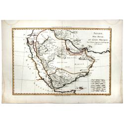
ARABIE, MER ROUGE, ET GOLFE PERSIQUE.
A detailed map of Saudi Arabia, the Red Sea, Persian Gulf and more. With mostly coastal information, interior largely left blank. Sets of mileage scales.
Date: Paris, 1780
Selling price: ????
Please login to see price!
Sold in 2020