![[Holy Land, Cyprus]](/uploads/cache/84451-250x250.jpg)
[Holy Land, Cyprus]
Attractive colored woodcut map showing the Holy Land with Cyprus. With a ship and a sea monster. From a Latin edition of Cosmographia by Sebastian Munster.
Date: Petri, Basle, ca. 1550
Selling price: ????
Please login to see price!
Sold in 2020
![Von den Laendern Asie [Palestine]](/uploads/cache/18623-250x250.jpg)
Von den Laendern Asie [Palestine]
Sebastian Münster, 1489-1552, outstanding geographer of Basle. Editied Ptolemy's atlas ' Geographia Universalis', editions 1540,-42, -45, -51 and -52. Published his "...
Date: Basle, 1550
Selling price: ????
Please login to see price!
Sold
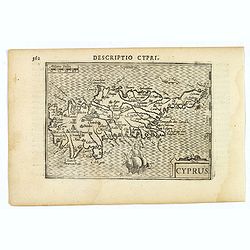
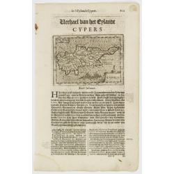
![[Lot of 2 leaves with map of Cyprus]](/uploads/cache/48277-250x250.jpg)
[Lot of 2 leaves with map of Cyprus]
Two printed text leaves relating to Cyprus with a map (10 x 15 cm). From the 1552 Latin text edition of Münster's Cosmographia, which is a short and complete summary of R...
Date: Basel, 1552
Selling price: ????
Please login to see price!
Sold in 2022
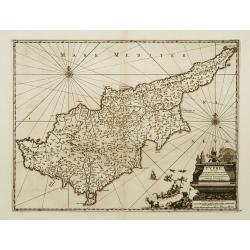
![[Cyprus].](/uploads/cache/41984-250x250.jpg)
[Cyprus].
Woodcut Ptolemaic-style map by Sebastian Münster figuring Cyprus, published in the edition of Strabo by Henri Petri in 1571."Strabonis rerum geographicarum" is ...
Date: Basle, Henri Petri, 1571
Selling price: ????
Please login to see price!
Sold in 2018
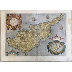
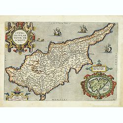
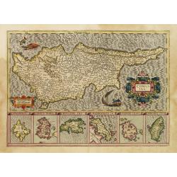
Cypri insulae nova descript.
A milestone in the history of cartography of Cyprus, based on a 1570 map by Giacomo Franco. The map is embellished by sailing ships and a sea monster, bearing a map of Le...
Date: Antwerp, 1573
Selling price: ????
Please login to see price!
Sold in 2020
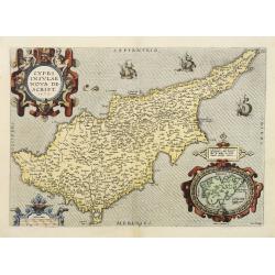
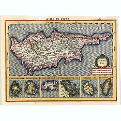
Cypri Insulae Nova descript. 1573.
This is a beautiful copy of a classic map of Cyprus. It is the earliest obtainable version of the best map of Cyprus made to date. Ortelius based his map upon that publis...
Date: Antwerp, 1574
Selling price: ????
Please login to see price!
Sold in 2011
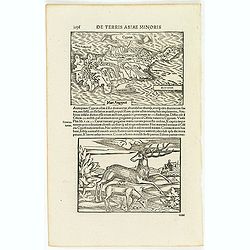
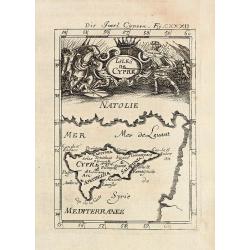
![[Cyprus]](/uploads/cache/26211-250x250.jpg)
[Cyprus]
Two woodcuts on one page. In upper part a map of Cyprus, in lower part a jumping deer and a sheep drinking water. The drinking sheep with old pen scratches. From his Cosm...
Date: Basle, 1550-1580
Selling price: ????
Please login to see price!
Sold in 2008
![[Cyprus]](/uploads/cache/92347-250x250.jpg)
[Cyprus]
Very early map of Cyprus, by Sebastian Münster from his Cosmographia. On a full sheet with text on both sides in German, and a print of deer.
Date: Basel, 1550-1580
Selling price: ????
Please login to see price!
Sold in 2013
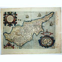
Cypri Insulae Nova descript. 1573.
This is a beautiful copy of a classic map of Cyprus. It is the earliest obtainable version of the best map of Cyprus made to date. Ortelius based his map upon that publis...
Date: Antwerp, 1581
Selling price: ????
Please login to see price!
Sold in 2014
CYPRI INSULAE NOVA DE SCRIPT 1573 - LEMNOS INSULAE.
A striking, old colored example of this important early map of Cyprus from Ortelius' Theatrum Orbis Terrarum, the first modern atlas of the world. Large inset of Lemnos. ...
Date: Antwerp, 1584
Selling price: ????
Please login to see price!
Sold in 2019
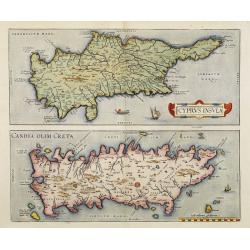
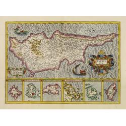
Cyprus Insula / Candia, Olim Creta.
Two maps on one sheet. Copper engraving illustrating Cyprus and Crete, with Latin text on verso. From 1584 onwards editions of the Ortelius atlas no longer included this ...
Date: Antwerp, 1570-1584
Selling price: ????
Please login to see price!
Sold in 2008
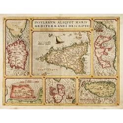
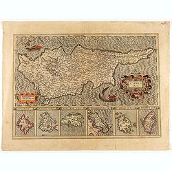
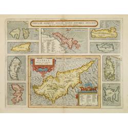
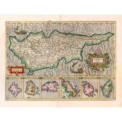
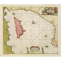
Insularum Aliquot Maris Mediterranei Descriptio.
The decorative composite map of six Mediterranean islands. The larger Sicily map is surrounded by maps of Sardinia, Corfu, Zerbi, Elba, and Malta. Each map is well detail...
Date: Antwerp, 1587
Selling price: ????
Please login to see price!
Sold
Cyprus.
Two woodcuts on one page. In upper part a map of Cyprus, in lower part a jumping deer and a sheep drinking water. The drinking sheep with old pen scratches. . From a Lati...
Date: Basle, 1550-1590
Selling price: ????
Please login to see price!
Sold in 2012
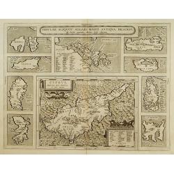
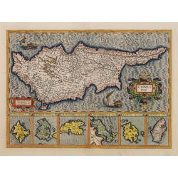
Insular. Aliquot Aegaei Maris Antiqua Descrip.
Ten maps on one plate. Showing Rinia and Dilos, Nicaria, Euboea, Samos, Keos (near Euboea), Rhodus, Chios, Cyprus, Lesbos, Lemnos.This map belongs to a series of historic...
Date: Antwerp 1595
Selling price: ????
Please login to see price!
Sold
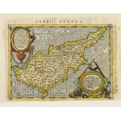
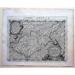
Cypri Insvla.
Lovely copper engraved map of the island of Cyprus featuring two large cartouches and fancy lettering in the seas. Good detail in the interior.The map comes from a scarce...
Date: Cologne 1597
Selling price: ????
Please login to see price!
Sold
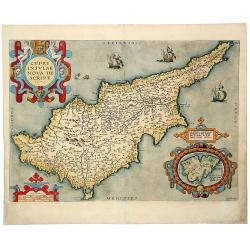
Cypri Insulae Nova descript. 1573.
This is a beautiful copy of a classic map of Cyprus. It is the earliest obtainable version of the best map of Cyprus made to date. Ortelius based his map upon that publis...
Date: Antwerp, 1598
Selling price: ????
Please login to see price!
Sold in 2012
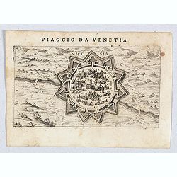
Nicosia.
A very rare view of Nicosia, also known as Lefkosia, the divided capital city of Cyprus and published in the first edition of "Viaggio da Venetia, a Costantinopoli. ...
Date: Venice, Giacomo Franco, 1598
Selling price: ????
Please login to see price!
Sold in 2020
![Cipro [Map of Cyprus]](/uploads/cache/45237-250x250.jpg)
Cipro [Map of Cyprus]
Very rare map of Cyprus Island published in the first edition of "Viaggio da Venetia, a Costantinopoli. Per Mare, e per Terra, & infieme quello di Terra Santa. D...
Date: Venice, Giacomo Franco, 1598
Selling price: ????
Please login to see price!
Sold in 2020
CYPRUS INS:
A decorative map of Cyprus, with insets for the other six islands.
Date: Amsterdam 1606
Selling price: ????
Please login to see price!
Sold
CYPRUS INS:
A decorative map of Cyprus, with insets for the other six islands.
Date: Amsterdam, 1606
Selling price: ????
Please login to see price!
Sold in 2020
CYPRUS INS:
A decorative map of Cyprus, with insets for the other six islands.
Date: Amsterdam 1606
Selling price: ????
Please login to see price!
Sold
Cyprus.
A decorative miniature map of the eastern Mediterranean island of Cyprus, published by Petrus Bertius in Amsterdam, at the beginning of the seventeenth century. This attr...
Date: Amsterdam, 1606
Selling price: ????
Please login to see price!
Sold in 2019
Cyprus, Rhodus. . .
Early map of Cyprus with inset maps of Rhodes, Cerigo, Negroponte, Mytilene, Kéos and Stalimene at the bottom.From the first French-text edition of Jodocus Hondius' Atlas...
Date: Amsterdam, 1608
Selling price: ????
Please login to see price!
Sold in 2008
Cypri Insula.
An attractive copper engraved map of Cyprus by Magini (1555-1617) from Geographiae, tum veteris, tum novae, volumina duo., published by Johannes Jansson. Overall size: 17...
Date: Arnhem, 1617
Selling price: ????
Please login to see price!
Sold in 2018
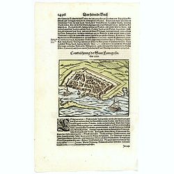
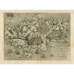
Contrafehtung der Statt Famagusta.
Munster's small, but delightful town plan of the Cypriot city of Famagusta, based largely on the view of the city by Braun & Hogenberg of 1572. Published in Munster's...
Date: Basle, ca 1620
Selling price: ????
Please login to see price!
Sold in 2020
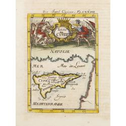
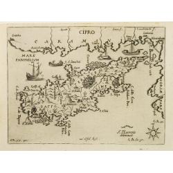
![Cipro [ Cyprus ]](/uploads/cache/14409-250x250.jpg)
Cipro [ Cyprus ]
One of the earliest separate maps of Cyprus. Includes decorative cartouche, sea monsters. Nice wide margin example, with Italian text. A decorative compass rose lies in l...
Date: Padova, (1572-) 1620
Selling price: ????
Please login to see price!
Sold
Cyprus.
Small map of Cyprus, surrounded by text in Dutch. Embellished with a sea monster and 2 vessels.Nicolaes de Clerck (de Klerc) was active as engraver and publisher in Delft...
Date: Amsterdam, Cloppenburch, 1621
Selling price: ????
Please login to see price!
Sold
Cyprus.
Small map of Cyprus, surrounded by text in Dutch. Embellished with a sea monster and 2 vessels.Nicolaes de Clerck (de Klerc) was active as engraver and publisher in Delft...
Date: Amsterdam, Cloppenburch, 1621
Selling price: ????
Please login to see price!
Sold
Insular. Aliquot Aegaei Maris Antiqua Descrip.
Ten maps on one plate. Showing Rinia and Dilos, Nicaria, Euboea, Samos, Keos (near Euboea), Rhodus, Chios, Cyprus, Lesbos, Lemnos.This map belongs to a series of historic...
Date: Antwerp, 1624
Selling price: ????
Please login to see price!
Sold
Isle de Cipre.
Early copper engraved map showing a deformed Cyprus, engraved by Henry Raignauld. Oversized depiction of the towns of Nicosia, Limosol and Famagusta. A numbered key (1-16...
Date: Paris, Michael Soly, 1629
Selling price: ????
Please login to see price!
Sold
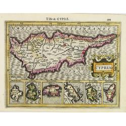
![Cyprus Ins[ula].](/uploads/cache/38664-250x250.jpg)
Cyprus Ins[ula].
A nice map of Cyprus, and in the lower part 6 small insets of: Stalimini, Chius, Mitilene, Negroponte, Cerigo, Rhodus... published in Cloppenburg's rare French version of...
Date: Amsterdam, 1630
Selling price: ????
Please login to see price!
Sold in 2016
Cyprus Ins.
A decorative map of Cyprus, with six inset maps of Stalimini, Chius, Mitilene, Negroponte, Cerigo, and Rhodes. The map's engraver was likely Jodocus Hondius. Though Hondi...
Date: Amsterdam 1630
Selling price: ????
Please login to see price!
Sold
Cyprus ins.
A nice map of Cyprus, and in the lower part 6 small insets of: Stalimini, Chius, Mitilene, Negroponte, Cerigo, Rhodus... published in Cloppenburg's rare French version of...
Date: Amsterdam, 1630
Selling price: ????
Please login to see price!
Sold in 2018
Cyprus Ins.
A decorative map of Cyprus, with six inset maps of Stalimini, Chius, Mitilene, Negroponte, Cerigo, and Rhodes.
Date: Amsterdam, 1633
Selling price: ????
Please login to see price!
Sold in 2017
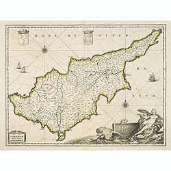
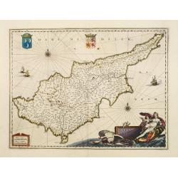
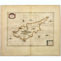
Cyprus Insulae.
Blaeu's beautiful map of Cyprus embellished with a very decorative title cartouche, a scale cartouche, two coats of arms, two wind roses and three sailing ships.No text o...
Date: Amsterdam / Paris, ca. 1635
Selling price: ????
Please login to see price!
Sold in 2012
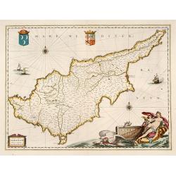
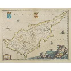
Cyprus Insulae.
Blaeu's beautiful map of Cyprus embellished with a very decorative title cartouche, a scale cartouche, two coats of arms, two wind roses and three sailing ships.
Date: Amsterdam, 1635
Selling price: ????
Please login to see price!
Sold in 2016
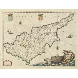
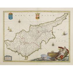
Cyprus Insulae.
Blaeu's beautiful map of Cyprus embellished with a very decorative title cartouche, a scale cartouche, two coats of arms, two wind roses and three sailing ships.As Willem...
Date: Amsterdam, 1638
Selling price: ????
Please login to see price!
Sold in 2018
Cyprus Insulae.
Janssonius' beautiful chart of Cyprus embellished with a very decorative title cartouche.
Date: Amsterdam 1640
Selling price: ????
Please login to see price!
Sold
Cyprus Insulae.
Janssonius' beautiful map of Cyprus embellished with a very decorative title cartouche.
Date: Amsterdam, 1640
Cyprus Insula.
Blaeu's beautiful map of Cyprus embellished with a very decorative title cartouche, a scale cartouche, two coats of arms, two wind roses and three sailing ships.With &quo...
Date: Amsterdam, 1640
Selling price: ????
Please login to see price!
Sold
Cyprus.
Detailed miniature map of Cyprus, from a German text edition of his Atlas Minor. Engraved by Petrus Kaerius.
Date: Amsterdam (1628) 1648
Selling price: ????
Please login to see price!
Sold
Cyprus Insula laeta choris, blandorum et mater amorum.
A classical map of Cyprus from Janssonius' historical atlas "Accuratissima Orbis Antiqui". With a rococo style title cartouche and similar explanation table in ...
Date: Amsterdam, ca 1650
Selling price: ????
Please login to see price!
Sold in 2017
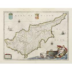
Cyprus Insulae.
Blaeu's beautiful map of Cyprus embellished with a very decorative title cartouche, shows Leda being drawn across the sea by a pair of swans.
Date: Amsterdam, 1658
Selling price: ????
Please login to see price!
Sold
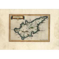
Cyprus Ex deliniatione Ubonis Emmii
A very scarce small map of Cyprus drawn by Ubonis Emmii and based on the Parergon map of Ortelius. Its shape is rather deformed and it has fewer ancient place names than ...
Date: Amsterdam, 1661
Selling price: ????
Please login to see price!
Sold in 2008
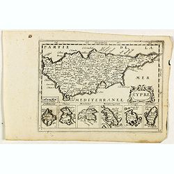
Cypre.
Rare map of Cyprus with decorative title cartouche. Below six small inset maps of Greek islands at bottom of page published by Jollain in 1667. Published in "Trésor ...
Date: Paris, 1667
Selling price: ????
Please login to see price!
Sold in 2018
Isles de Cypre.
A charming late 17th century French map of Cyprus with a large pictorial cartouche depicting an infantry combat.By Allain Manneson Mallet (1630-1706), a well traveled mil...
Date: Franckfurt 1684
Selling price: ????
Please login to see price!
Sold
Die Insel Cypern / Isles de Cypre
Decorative engraved map of Cyprus from Alain Manesson Mallet. With a interesting battle scene.
Date: Frankfurt, 1686
Selling price: ????
Please login to see price!
Sold in 2009
De Beschryving van de Reysen Pauli en Van de Andere Apostelen.
The Dutch so-called ' Staten' bibles published between 1637 and c. 1760, contained 5 maps: The World, ' Paradise', The Perigrinations, The Promised Land Canaan, The Trave...
Date: Dordrecht-Amsterdam, H. Keur en M. Doornik, 1686
Selling price: ????
Please login to see price!
Sold
De Gelegentheyt van t' Paradys en t' Landt Canaan, mitsgaders d' eerst bewoonde Landen der Patriarchen.
Dutch so-called ' Staten' bibles, published between 1637 and c. 1760, contained 5 maps: The World, ' Paradise', The Perigrinations, The Promised Land Canaan, The Travels ...
Date: Amsterdam, Hendrik Keur en Marcus Doornick, 1688
Selling price: ????
Please login to see price!
Sold in 2009
CIPRO
Rare map of the island of Cyprus from Francesco Piacenza's : L'Egeo Redivivo o'sia Chrorographia dell'Arcipelago, e dello stato primiero, & attuale di quell'isole, re...
Date: Modena, 1688
Selling price: ????
Please login to see price!
Sold
M. Heberers Ongelukige Voyagie gedaan in Verscheyde gedeeltens van Asia en Africa.
Pieter van der Aa was a prolific publisher. He published a.o. ' Naaukeurige versameling der gedenkwaardigste zee- en land-reysen', a series of accounts of voyages (1706-0...
Date: Leiden, 1707
Selling price: ????
Please login to see price!
Sold
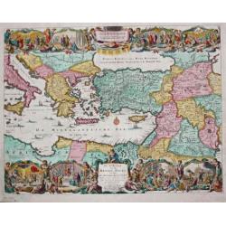
Paskaart van 't Oosterste deel vande Middellantsche Zee Vervattende de Zee-kusten van Caramania Cyprus Soria en Aegiptia.
This sea chart represents Cyprus as well as the eastern coasts of the Mediterranean Sea.From van Keulen's "De Nieuwe Groote Lichtende Zee-Fackel, part III.3.3. The a...
Date: Amsterdam, 1708
Selling price: ????
Please login to see price!
Sold
Cypre, île de la Méditerrannée.
This map by van der Aa copies the Cyprus map of Willem Blaeu . It is smaller in size and Blaeu's exquisite decorative treatment has been replaced by a cartouche and new p...
Date: Leiden 1730
Selling price: ????
Please login to see price!
Sold
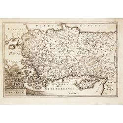
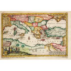
Asia Minor.
Christoph Cellarius (1638-1707). Geographia Antiqua, 1686.A map of Turkey and Cyprus. Embellished with a nice title-cartouche.
Date: Leipzig, Gledisch, 1732
Selling price: ????
Please login to see price!
Sold in 2008
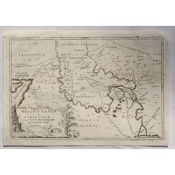
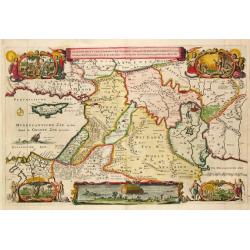
Mesopotamia E Babilonia Coifmi Delineati Secondovna.
A fine copperplate map of current-day Armenia, Syria, Cyprus & Iraq. An Italian edition by Cellarius in 1740. It features a decorative cartouches including building...
Date: Amsterdam, 1740
Selling price: ????
Please login to see price!
Sold in 2023
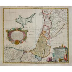
Palestina seu Terra olim Sancta.
Homann Heirs (of Johann Baptist and Johann Christof) published: Grosser Atlas, 1731, 1737. Geogr. Maior, 1759, Atlas Homannianus, 1762.A map of Palestine and the Libanon ...
Date: Nürnberg, 1744
Selling price: ????
Please login to see price!
Sold
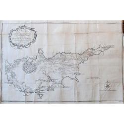
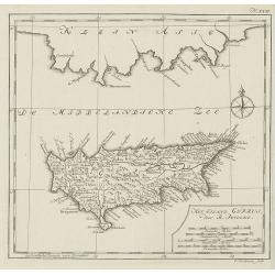
To George Wakeman Esq, Consul for his Majesty the King of Great Britain in the Island of Cyprus. This Map of the Island of Cyprus is dedicated by his friend and servant A. Drummond.
A rare large scale map Cyprus. It is one of the most important cartographic sources of Cyprus during the Turkish occupation in the 18th century. Curiously, some place-nam...
Date: London, 1754
Selling price: ????
Please login to see price!
Sold in 2018
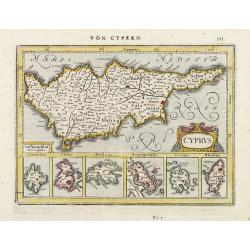
Het eiland cyprus door R.Pococke.
Rare map of Cyprus from a Dutch edition of ""Description Of The East And Some Other Countries" by R. Pococke. "Beschryving van het Oosten enz. Door de...
Date: Amsterdam/ Rotterdam, 1780
Selling price: ????
Please login to see price!
Sold in 2010
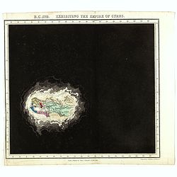
B.C. 529. Exhibiting the Empire of Cyprus.
Plate from An historical atlas: in a series of maps of the world as known at different periods constructed upon an uniform scale and colored according to the political ch...
Date: London, 1830
Selling price: ????
Please login to see price!
Sold in 2024
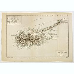
Cyprus Insula ad Stadiasmum Maris Magni S. 297-317
Delicate map of ancient Crete according to the "Stadiasmus Maris Magni", prepared by Karl Wilhelm Ludwig Muller (1813-1894) and published in "Geographi Gra...
Date: Paris, Ambrosio Firmin Didot, 1855
Selling price: ????
Please login to see price!
Sold in 2017
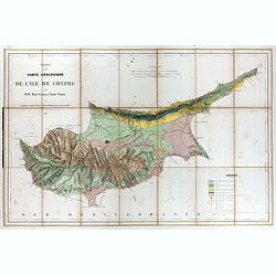
Essai d'une carte géologique de l'Ile de Chypre.
Geological map of Cyprus prepared by Albert Gaudry (1827-1908), professor at Muséum d'histoire naturelle and member of the London Royal society of Sciences.A color key in...
Date: Paris, 1862
Selling price: ????
Please login to see price!
Sold in 2017
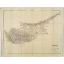
Cyprus. / London Atlas map of Cyprus.
With decorative cover title: LONDON ATLAS MAP OF CYPRUS. LONDON EDWARD STANFORD Ltd. Cartographer to the King, / 12, 13 & 14, LONG ACRE, W.C. and 29 & 30 Charing ...
Date: London, 1887
Selling price: ????
Please login to see price!
Sold in 2009
