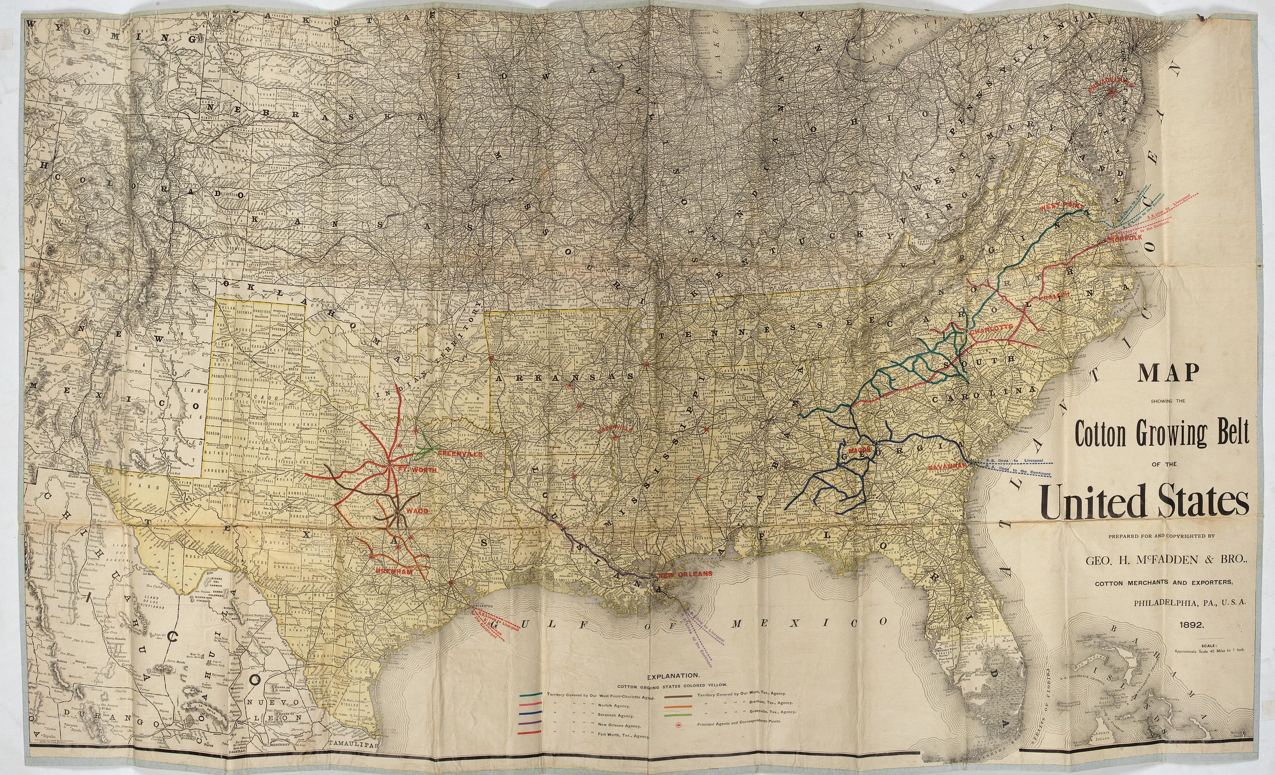
Map showing the cotton growing belt in the United States Prepared for and copyrighted by Geo. H.Mc.Fadden & Bro., cotton merchands based in Phiiladelphia, USA 1892. |
||||||||||||||||||||
|
||||||||||||||||||||
|
|
||||||||||||||||||||
$1000 / ≈ €874This item is available for immediate sale! Questions before Buying ?
We are happy to answer your questions.
1000.00
|
My Collection +
Add this or any of your favorite items in one place. If you want to save the items permanently, you have to sign in or create an account first. |
|||||||||||||||||||
Description
The cotton-growing Belts in the Southern States for 1892
A rare map showing the cotton-growing Belts in the Southern States for 1892. Prepared for and copyrighted by Geo. H. Mc.Fadden & Bro., cotton merchants based in Philadelphia.With a color key at the bottom. The cotton-growing states are in yellow. Scale 45 miles to 1 inch.
Interestingly, the map was published in 1892, when the boll weevil insect (Anthonomus grandis Boheman), a small beetle about ¼ inches long, native to Mexico and Central America, entered the United States near Brownsville, Texas. By the mid-1920s, it remained North America's most destructive cotton pest.
John Howard McFadden was a cotton merchant for George H. McFadden & Brothers and an art collector and philanthropist. McFadden gave the Pennsylvania Museum, Memorial Hall, and Fairmont a collection of Antarctic specimens given to him by the explorer Sir Ernest Shackleton. The collection included flora, minerals and photographs. McFadden helped finance Sir Shackleton's trans-Antarctic expedition.
McFadden began collecting art in 1892 and, by 1895, had concentrated exclusively on important British paintings.
During his twenty-year collection period, he dealt only through the London firm of Thomas Agnew & Sons, relying on the advice of close friend William Lockett Agnew. The First World War interrupted his collecting, and he returned to America in 1913. Back in England in 1916, McFadden hired William Roberts, an art historian/antiquarian bookseller, to catalogue his collection.
McFadden was a trustee of Jefferson Hospital and of the Pennsylvania School of Industrial Art, director of the Academy of the Fine Arts, member of the Union League and Arts Clubs, Philadelphia; of the Metropolitan and New York Yacht Clubs, New York and the Junior-Carlton Club, London (Hill, 1921).
McFadden was married to Florence De Witt Bates and they had three children. [Source:The Historical Register edited by Edwin Charles Hill]
FAQ - Guarantee - Shipping
Buying in the BuyNow Gallery
This item is available for immediate purchase when a "Add to Cart" or "Inquire Now" button is shown.
Items are sold in the EU margin scheme
Payments are accepted in Euros or US Dollars.
Authenticity Guarantee
 We provide professional descriptions, condition report (based on 45 years experience in the map business)
Paulus Swaen warrants the authenticity of our items and a certificate of authenticity is provided for each acquired lot.
Condition and Coloring
We indicate the condition of each item and use our unnique HiBCoR grading system in which four key items determine a map's value: Historical Importance, Beauty, Condition/Coloring and Rarity.
Color Key
We offer many maps in their original black and white condition. We do not systematically color-up maps to make them more sellable to the general public or buyer.
Copper engraved or wood block maps are always hand colored. Maps were initially colored for aesthetic reasons and to improve readability. Nowadays, it is becoming a challenge to find maps in their original colors and are therefor more valuable.
We use the following color keys in our catalog:
Original colors; mean that the colors have been applied around the time the map was issued.
Original o/l colors; means the map has only the borders colored at the time of publication.
Colored; If the colors are applied recently or at the end of the 20th century.
Read more about coloring of maps [+]
Shipping fee
A flat shipping fee of $ 30 is added to each shipment by DHL within Europe and North America. This covers : International Priority shipping, Packing and Insurance (up to the invoice amount).
Shipments to Asia are $ 40 and rest of the world $50
We charge only one shipping fee when you have been successful on multiple items or when you want to combine gallery and auction purchases.
Read more about invoicing and shipping
FAQ
Please have a look for more information about buying in the BuyNow gallery
Many answers are likely to find in the general help section.
My Collection+
![]()
With My Collection+ you can collect all your favorite items in one place. It is free, and anyone can create his or her virtual collection.
Unless you are logged in, the item is only saved for this session. You have to be registed and logged-in if you want to save this item permanently to My Collection+.
Read More[+]
Register here, it is free and you do not need a credit card.
Add this item to
My Collection+
or click the following link to see My Collection+.
| Digital Image Download | |
|
Paulus Swaen maintains an archive of most of our high-resolution rare maps, prints, posters and medieval manuscript scans. We make them freely available for download and study. Read more about free image download |
Click the image for a free small image download. |
In accordance with the EU Consumer Rights Directive and habitually reside in the European Union you have the right to cancel the contract for the purchase of a lot, without giving any reason.
The cancellation period will expire 14 calendar days from the day after the date on which you or a third party (other than the carrier and indicated by you) acquires, physical possession of the lot. To exercise the right to cancel you must inform Paulus Swaen Inc, of your decision to cancel this contract by a clear statement (e.g. a letter sent by post, or e-mail.
To meet the cancellation deadline, it is sufficient for you to send your communication concerning your exercise of the right to cancel before the cancellation period has expired.
