Popular Listings in America
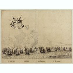
Quartum Praelium Coniovian inter et Fluvium Rio Grande XVII Ian
Decorative engraving of the fourth sea battle with the Portuguese fleet offshore at the Rio Grande, in1640. Engraved by J. van Brosterhuyzen after a design by Frans J. Po...
Date: Joannes Blaeu, Amsterdam 1647
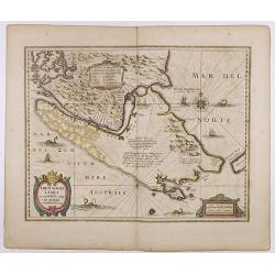
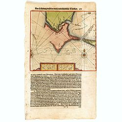
Freti Magellanici ac novi Freti vulgo Le Maire. . .
A fine map of Tierra del Fuego. With an explanatory text of the passage by Barent Jansz. Potgieter, who accompanied Captain Sebald de Weert to the Straits in 1599/1600, w...
Date: Amsterdam, ca. 1633

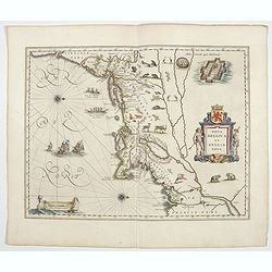
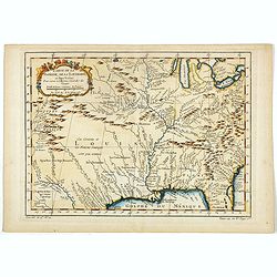
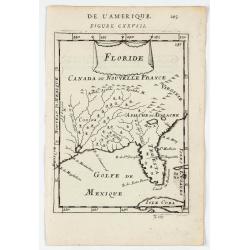
La Floride. . .
The map is derived from La Floride , 1657, by Nicolas Sanson. Several new rivers appear in Virginia. The Caroline listed is Ft. Caroline, not the Carolinas. The Florida n...
Date: Paris, 1683

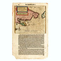
Tierra Nueva.
Uncommon first edition of this early map of the east coast is an enlarged version of Giacomo Gastaldi map published in 1548. Nomenclature and cartography are unchanged, w...
Date: Venice, 1561
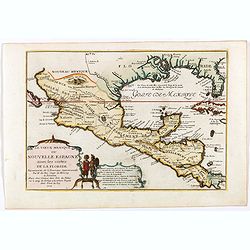
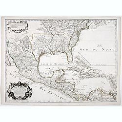
Le vieux Mexique ou nouvelle Espagne. . .
Attractive map covering the Gulf of Mexico through Central America also including parts of Cuba and Jamaica. It extends through Mexico to show the southern tip of Baja Ca...
Date: Paris, 1705
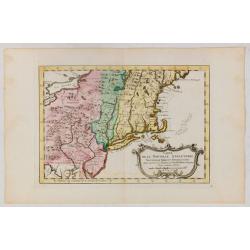
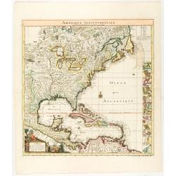
Nova Belgica et Anglia Nova.
The first Dutch settlers arrived in 1614 and settled at Fort Nassau (located near the Port of Albany).Oriented with north to the right. This is one of the earliest maps t...
Date: Amsterdam, 1644
Caarte vande nieuwe Passagie bezuijden de Strate Magellan. . . / Description de nouveau passage vers le zud du destroit de Maggellan. . .
Map showing the new route around the bottom of South America discovered by Schouten and Le Maire: through the Le Maire Strait, around the Barnevelt Islands, and past Cape...
Date: Frankfurt am Main, 1619

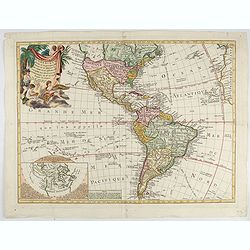
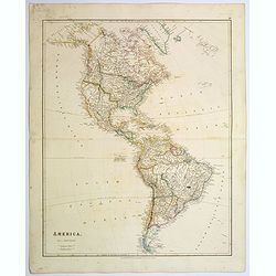
Carte générale de l' Amérique divisée en ses principaux états . . .
Map of North and South America. By C. F. Delamarche, successor of Robert de Vaugondy, Geographer. Descriptive text to the left.
Date: Paris, 1820
![Arcis Carolinae delineatio [Jacksonville]](/uploads/cache/48530-250x250.jpg)
Arcis Carolinae delineatio [Jacksonville]
Depicting Fort Caroline in Jacksonville, Florida. A French expedition, organized by Protestant leader Admiral Gaspard de Coligny and led by the French Explorer Jean Ribau...
Date: Frankfurt, 1594
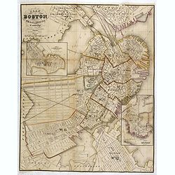
Plan Of Boston Comprising a Part of Charlestown and Cambridge. Published by George G. Smith, Engraver, Washington Street Boston 1855..
Important and detailed plan of Boston, with insets :"Plan Of East Boston from actual Survey by R.H. Eddy" and "Plan Of South Boston From a Drawing by S.P. ...
Date: Boston, ca. 1859
Waschinga Sahba's Grab.. (Wakonda Creek.)
Original aquatint engraving for Travels in the Interior of North America between 1832-34 . Engraved by Ch. Vogel. The finest work on American Indian life and the American...
Date: London/ Paris/ Coblenz, 1839

Carte des Possessions Françoises et Angloises dans le Canada, et partie de la Louisiane.
First state of this separately published map of the European Colonies in the New World east of the Mississippi River. This map was published in 1756 to provide informatio...
Date: Paris, 1756

United States of North America. Carte des Etats-Unis de l'Amerique Septentrionale / copiée et gravée sur celle d'Arrowsmith, corrigée et considérablement augmentée... par P. F. Tardieu...
FIRST EDITION. An impressive wall map here in 4 unjoined sheets and large margins. RARE in these untouched, full sheets. Recorded examples are usually offered as folding ...
Date: Paris: An XI - 1802

Nieuwe kaart van Kanada . . .
Nice map of the Bay of Hudson, In Labrador, a small inset of Nova Scotia. The map is dated 1769. All text is in Dutch. The map shows the region shortly after the conclusi...
Date: Amsterdam, 1769
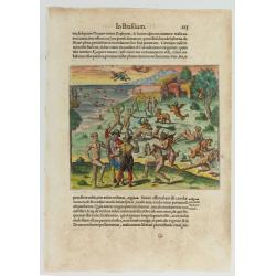
![[Navel battle between Portuguese and French Battle off Buttugar (Brazil).]](/uploads/cache/48526-250x250.jpg)
[Navel battle between Portuguese and French Battle off Buttugar (Brazil).]
Navel battle between Portuguese and French in the seas off the Poti guaran Territories in Brazil.Read more about "Les Grand Voyages" by Theodore De Bry [+]
Date: Frankfurt, 1594

Polus Arcticus cum vicinis regionibus.
1608 MERCATOR, G. / HONDIUS, J. - Rare map of the North Pole, shown as a rocky island surrounded by 'in-drawing seas' between four huge islands
Date: Amsterdam, 1608

Région arctique.
1877 VIVIEN DE SAINT MARTIN, L. - Map of the North Pole, together with the often missing overlay with the Arctic expedition of Captain Nares.
Date: Paris, Hachette, 1877

Portrait de Benjamin Franklin.
Portrait de Benjamin Franklin. From Giulio Ferrario's work Le Costume ancien et moderne ou histoire du gouvernement, de la milice, de la religion, des arts, etc. publishe...
Date: Milan, 1827
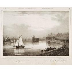
Pierpont's distillery on Long Island.
Milbert's topographical prints are an eyewitness record of life in America in the early 19th centuryDecorative print after Jacques Milbert, and lithographed by Sabatier a...
Date: Paris, 1829
![[United States map with Ottoman script.]](/uploads/cache/44314-250x250.jpg)
[United States map with Ottoman script.]
Postcard-size map in Ottoman script showing the United States, prepared by Mehmet EŞREF in a small atlas: عمومولاياةىشهانيىحاوىكوچكاطلاس [Umum-i vilayat-ı Şahaneyi havi...
Date: Istanbul, 1325 or 1909

A Hysterical Map Of Death Valley National Monument -- And It's Looking Mighty Low
First edition Humorous map of Death Valley. "Drawn In Broken English by Jolly Lindgren," this comic pictorial map is full of puns and comic vignettes related to...
Date: Spokane, Wash., Lindgren Brothers, 1948

Mappa Geographica provinciae Nova Ebboraci ab Anglis NEW-YORK dictae. . .
During the Revolution, this map afforded British commanders an excellent overview of areas that would be crucial in the early years of the war, particularly the Hudson Va...
Date: Nuremberg, 1778

Map of Pensylvania and New Jersey by H.S. Tanner.
First edition of this rare and important map of Pennsylvania and New Jersey by H.S. Tanner and published in his "New American Atlas" from 1823. Includes roads, ...
Date: Philadelphia, Henry Tanner, 1823
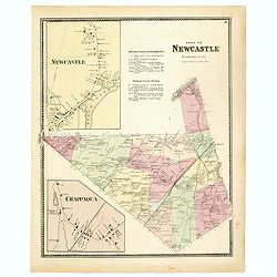
Town of New Castle. Westchester Co. NY.
Fine lithographed map of the town of New Castle. The map provides the names of specific homeowners, as well as information about the occupations and physical locations of...
Date: New York, 1867
![[ North and South America with telegraph cables, with Ottoman script]](/uploads/cache/44330-250x250.jpg)
[ North and South America with telegraph cables, with Ottoman script]
Postcard size map showing North and South America with telegraph cables. The map is in Ottoman Arabic-script prepared by Mehmet EŞREF in a small atlas : عمومولاياةىشهاني...
Date: Istanbul, 1325 or 1909
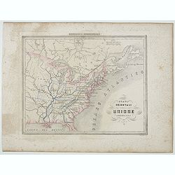
Stati Orientali della Unione Americana.
Uncommon map of Northeastern America prepared by Francesco Costantino Marmocchi. Above the map "Geografia Commerciale". From "Il Globo Atlante di carte Geo...
Date: Genova, Paolo Rivara fu Giacomo, 1858

Dutton Map of the Grand Canyon, Arizona (in 4 joined sheets)
An important 1882 map of the Grand Canyon, Arizona, published in "Atlas To Accompany The Monograph On The Tertiary History Of The Grand Canon District By Capt. Clare...
Date: Julius Bien and Co., 1882
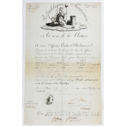
Passeport.
Passport for the United States in the name of Madeleine Lavit Femme Lory, issued by the Commission of Interior Relations and approved by the Committee of Public Safety.Th...
Date: Paris, 1795

The Greyhound Map of This Amazing America. . .
A large colored lithograph map of the USA, published by the Greyhound Corporation during the Second World War. The map demonstrates where all the Greyhound bus routes int...
Date: United States, 1941

Mappa geographica Provinciæ Nova Eboraci ab Anglis New-York . . .
Lower part of the two sheets map of Homann Heirs' edition of Sauthier's celebrated map of New York and New Jersey, made during the Revolutionary War. Appears in Homann's ...
Date: Nuremburg, 1778

Missions et Résidences dans la Partie Septentrionale de l'Amérique Contenant 50 Jésuites.
Very rare missionary map of North America from "Atlas Universel indiquant les établissemens des Jésuites: avec la manière dont ils divisent la terre, suivi desévénem...
Date: Paris, Ambroise Dupont , 1826
![Etats-Unis de L'Amerique Septentrionale. [Two sheets in manuscript ]](/uploads/cache/03972-250x250.jpg)
Etats-Unis de L'Amerique Septentrionale. [Two sheets in manuscript ]
Two sheets giving detailed information in French about the population in 1810, principal cities, products of industry and commerce, the financial situation for 1818, etc....
Date: France, ca. 1819
Cacodemon attacking the savages.
Cacodemon ("evil spirit") attacking the savages. Read more about "Les Grand Voyages" by Theodore De Bry [+]
Date: Frankfurt, 1594
Carte de la Floride, de la Louisiane, et Pays Voisins. . .
Jacques Nicolaas Bellin (1703-1772) was one of the most important and proficient French cartographers of the mid-eighteenth century. He was appointed the first Ingenieur ...
Date: Paris, 1757
Carta particolare del'mare del Zur che comincia con il capo S. Francesco nel Peru e finisce con il capo S. Lazaro nella nuova Spagnia.
FIRST EDITION Dudley’s magnificent chart of the Pacific Coast of Central and South America, from the coast of Columbia and Ecuador in the north to the Bay of Honduras in ...
Date: Florence 1661
Selling price: ????
Please login to see price!
Sold in 2023

Nieuwe Kaart van de Grootbrittannische Volkplantingen in Noord America waar in Tevens de Fransche Bezittingen en de Landen tuschen die Beide Volken. . .
A map of the east-coast of America from New Foundland till Florida, divided in French and British properties. Reduced size Dutch edition of Mitchell's map of North Americ...
Date: Amsterdam, 1769
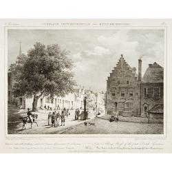
View in Albany-House of the first Dutch Governors.
Decorative print after Jacques Milbert, and lithographed by Tierpenne and the figures by Victor Adam.From Amérique Septentrionale. Printed by de Bove and Noöl ainé &C...
Date: Paris, 1829

Alabama. Official Highway map 1942.
Folding road map of Alabama. Published in Montgomery, Alabama by Paragon Press. Mileage chart and six city plans in margin; verso includes text and photos. Scale [ca. 1:8...
Date: Alabama, Paragon Press, 1942

System of Penal Law, prepared for the State of Louisiana , comprising codes of offenses and punishments, of procedure, of prison discipline, and of evidence applicable as well to civil as to criminal cases.
The "Enquiries" of Rush and Bradford and the Pennsylvania movement toward abolition of the death penalty had a little immediate impact on the practices of other...
Date: New-Orleans, Benjamin Levy, 1824
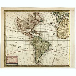
Nieuwe kaart van America.
An attractive map of both the Americas, by one of the leading mapmakers in 18th century Amsterdam. Isaak Tirion (d. 1769) was a Amsterdam publisher. His "Nieuwe en b...
Date: Amsterdam, 1765
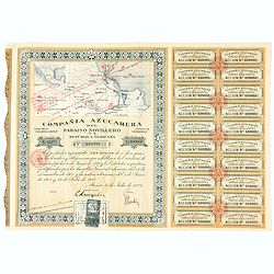
Accion de 10 pesos. No. 110,931 (Share certificate)
Beautifully engraved certificate from the "Compania Azucarera de Paraiso Novillero S.A. Republica Mexicana", share certificate No.110,931 for one share, in a $ ...
Date: Paris, 1924
L'Amerique Meridionale Dressée sur les Observations de Mrs de l'Academie Royale des Sciences . . .
Rare state of " L’Amerique Meridionale. Chez l’Auteur sur le Quai de l’Horloge a la Courone de Diamans avec Privilege du Roy pour 20 ans, 1700".Fine map of Sout...
Date: Paris, 1700

Nova tabula geographica complectens borealiorem..
A finely engraved pair of maps designed to be cut and joined together to provide a continuous coastline of North America from the Carolinas to Newfoundland and along the ...
Date: Amsterdam 1720
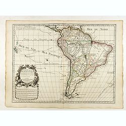
(South America) - Delineatio omnium orarum totius Australis partis Americae, dictae Peruvianae, a R. de la Plata, Brasiliam Pariam, et Castellam auream una cum omnibus…
1593 LINSCHOTEN, J.H. van - Decorative map of South America, which goes as far north as part of Florida, is extremely well-detailed along the coast.
Date: Amsterdam, 1593

Carte du Golphe du Mexique et des Isles de l'Amerique.
Attractive map of the islands of the Caribbean that includes those parts of the United States & Mexico that border the Gulf of Mexico, Central America, and the northe...
Date: Paris, 1754
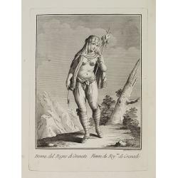
Dona del Regno di Granata. / Femme du Roy.me de Granade.
A full portrait of a woman from Granada, situated at Lake Nicaragua or Cocibolca. From "Raccolta di stampe", a series of historically significant eighteenth-c...
Date: Venice, Antonio Zatta, c.1790

Tartariae sive Magni Chami Imperium.
This is a very early depiction of the northern Pacific, with the first mapping of Northwest Coast of America and probably the first map to name California 'C. Califormio...
Date: Antwerp, c. 1608-1612
Floride.
A charming map of Florida, also showing Cuba, Golf of Mexico & St Augustine.Title in curtain draped at top. French text on verso.From the original 1683 text edition o...
Date: Paris, 1683
Carte du Mexique et de la Floride.
Third state, with "Quai de l'Horloge" imprint. Renard’s imprint has been erased”. It was the first printed map to portray accurately the course and mouth of the...
Date: Paris, 1703
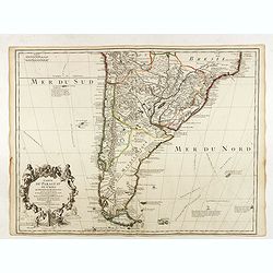
Carte du Paraguay du Chili.
A finely engraved, detailed map of the southern half of South America. Prepared by de l'Isle with the imprint "Chez l’Auteur sur le Quai de l’Horloge avec Privilege ...
Date: Paris, L. Renard, 1703

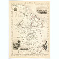
Upper Canada &c.
A beautiful, large scale map of Upper Canada, and portions of the American states of New York, Ohio, and Pennsylvania. The province of 'Upper' Canada was created by the B...
Date: London, 1839
![Mapa geral do Brasil / organizado pelos J. Carneiro da Silva e Pedro Voss. [Together with] Micro geografia do Brasil. [Together with] Pequeno Mapa do Brasil.](/uploads/cache/45466-250x250.jpg)
Mapa geral do Brasil / organizado pelos J. Carneiro da Silva e Pedro Voss. [Together with] Micro geografia do Brasil. [Together with] Pequeno Mapa do Brasil.
Large folding national map published by "Comp. Melhoramentos de São Paulo Industrias de Papel". Nova edicao revista 1946. Figures for all states. "Futuro D...
Date: São Paulo, 1946
Carte D'Amerique divisée en ses principaux Pays Dressée sur les Mémoires les plus recents, et sur differents Voyages et assujettie aux Observations Astronomiques de Mrs. de l'Academie Royal des Sciences Par Mr. l'Abbe Clouet . . . 1774.
The rare 1774 edition of this fine map of the western hemisphere published by Clouet in Rouen. A later edition with the date 1787 also exists. With inset map "Carte ...
Date: Paris, 1774

Uomo del Paraguai nell' America Meridionalle. / Homme du Paraguai dans l'Amerique Meridionalle.
Full portrait of a person from Paraguay. From "Raccolta di stampe." a series of historically significant eighteenth-century copper plate engravings by Venetian...
Date: Venice, Antonio Zatta, c.1790
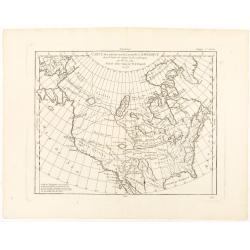
Nuovo Mondo parte Settentrionale.
Uncommon map of North America prepared by Francesco Costantino Marmocchi. Above the map "Geografia Commerciale". From "Il Globo Atlante di carte Geografich...
Date: Genova, Paolo Rivara fu Giacomo, 1858

Indiana del Perù. / Indienne du Perou.
Portrait of a Peruvian Indian woman holding a fruit basket and a lama in the background. From "Raccolta di stampe." a series of historically significant eighte...
Date: Venice, Antonio Zatta, c.1790
United States.
A lovely large map of the Untied States, as it was at the time of publication. Each state shown in a different outline color. Nothing is shown west of Louisiana, Arkansas...
Date: London, 1839
West Indies.
A fine, detailed steel engraved map comprising Florida, Bahamas, Cuba, Haiti, Jamaica, the Windward, and the Leeward Islands, the northern Columbian coastline, Panama, Gu...
Date: London, 1839

Amerique septentrionale divisee en ses principales parties, ou sont distingues les vns des autres les estats suivant qu'ils appartiennent presentemet aux Francois, Castillans, Anglois, Suedois, Danois, Hollandois...
This handsome map shows California as an island, open-ended Great Lakes, and other details based mainly on Sanson. A large decorative cartouche occupies the area of the n...
Date: Paris, after 1694
Sudseite des Landts Terza del Fuoco, abgezeichnet durch Iohan von Walbeck.
Map showing Cap Horn and the Terra del Fuego.From a German text edition of Theodor de Bry's travel book. The original copper plate is now shortened at the left side and h...
Date: Frankfurt am Main, 1630

Carte nouvelle de l'Amérique angloise contenant tout ce que les Anglois possèdent. . . avec la Floride / gravée. . . par Maththias Albert Lotter. . .
As mentioned in the title piece, the map includes the area at that time in the possession of the English, i.e. Canada, New Large, beautiful and detailed map of the Easter...
Date: Augsburg, 1777
Carte de la Nouvelle Angleterre, Nouvelle York et Pensilvanie / Pour servir à l'Histoire Générale des Voyages.
Uncommon edition of this accurate map the east coast from Delaware River till Main.Left hand corner Lake Ontario. In lower right engraved "38."From Atlas Portat...
Date: Amsterdam, 1773

Carte de la partie septentrionale des Etats Unis..
An attractive 1801 map of North America's east coast north of Long Island. Including St.Laurence River as far south as Lake Ontario. Engraved by André and P.F.Tardieu. A ...
Date: Paris, 1801
America.
A beautiful, large-scale map of the Americas. Alaska is named as 'Russian America', Texas is still a part of Mexico, yet to become a republic (1836), before finally becom...
Date: London, 1839
Selling price: ????
Please login to see price!
Sold in 2025
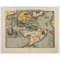
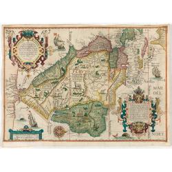
Die neüwen Inseln/ so hinder Hispanien gegen Orient bey dem land Indie ligen.
The earliest and one of the most important separate maps to show both Americas. Although it was not the first map to use “America” as a designation for the New World, it ...
Date: Basle 1561
Portulano de la Ameririca Setentrional construido en la direccion de tabajos.
The "Portulano de la America Setentrional", is an exceedingly rare Spanish sea atlas featuring charts of the Caribbean and the Gulf of Mexico. It was developed ...
Date: Madrid, 1818
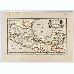
Audience de Mexico.
General map of Mexico after N.Sanson.From the book Nouvelle Relation, Contenant LES VOYAGES DE THOMAS GAGE dans la nouvelle Espagne [..] jusqu'à la Havane, published by P...
Date: Paris, 1756

La parte orientale dell' antico.. messico con la Florida..
A splendid two-sheet map of Mexico, including California, Arizona, New Mexico, part of Texas, Baja California and Mexico (west part) and of the Southeast Part of the US, ...
Date: Rome, Calcography, 1797-before 1839
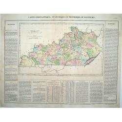
Carte Géographique .. Kentucky.
Detailed map of Kentucky. From J.A. Buchon, "Atlas Gégraphique Statistique, historique et chronologique des deux Ameriques et des isles adjacentes; traduit de l'atla...
Date: Paris, 1825

F. Louys.
A charming bird's-eye view of Fort St Louis at Cayenne. Title in curtain draped at top. French text on verso.The fort is located on Mont Cépérou, with a panoramic view o...
Date: Paris, 1683
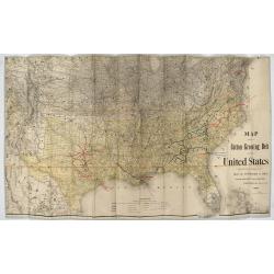
Map showing the cotton growing belt in the United States Prepared for and copyrighted by Geo. H.Mc.Fadden & Bro., cotton merchands based in Phiiladelphia, USA 1892.
The cotton-growing Belts in the Southern States for 1892 A rare map showing the cotton-growing Belts in the Southern States for 1892. Prepared for and copyrighted by G...
Date: Philadelphia, 1892
Carte des parties nord et ouest de L' Amerique. . .
An interesting map of North America, based upon an earlier map by Thomas Engel. His map of North America was issued in his 'Memoires Observations Geographique' in 1765, a...
Date: Paris, 1772
Amerique Septentrionale suivant la carte de Pople faite à Londres en 20 feuilles.
The key sheet to Henry Le Rouge/Popple wall map of the British Colonies in North America. Appears in the author's Atlas Général [1741-62].Key map of the French edition ...
Date: Paris, Le Rouge, 1742
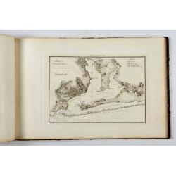
![[Haida Gwaii,] Baye Swallow . . . / Havre Byron /Côté septentrional de la plus grande des Isles de la Reine Charlotte. . . .](/uploads/cache/25888-250x250.jpg)
[Haida Gwaii,] Baye Swallow . . . / Havre Byron /Côté septentrional de la plus grande des Isles de la Reine Charlotte. . . .
Map of Swallow's Bay and a coastline profile of the Queen Charlotte Islands and Captain Byron's Heaven.Queen Charlotte Islands, with their modern name Haida Gwaii, is an ...
Date: Paris, 1774
De Nieuwe en Onbekende Weereld: of Beschryving van America en 't Zuid-Land.
FIRST EDITION. "This is a classic book on America and is much sought after by collectors of Americana as it contains, on p. 124, one of the first views of New York N...
Date: Amsterdam, Jacob Meurs, 1671
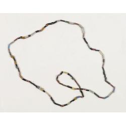
Dutch Trade Bead.
An extremely rare necklace made from authentic early 17th-century glass beads produced in the Netherlands. This rare and early Dutch Trade bead is built up from irregular...
Date: Middelburg, before 1623
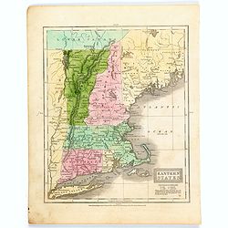
Eastern States.
A map of the eastern US seaboard from Long Island north to Lower Canada, comprising the states of Connecticut, Rhode Island, Massachusetts, New Hampshire, Maine, Vermont ...
Date: Connecticut, 1839
British Guayana.
A decorative steel engraved map of British Guyana. The last Tallis map of the region, published circa 1858 by The London Printing and Publishing Company (the partnership ...
Date: London, 1858
![[Lower half] Amerique Septentrionale avec les Routes, Distances en miles, Limites et Etablissements François et Anglois Par le Docteur Mitchel Traduit de 'Anglois..](/uploads/cache/49378-250x250.jpg)
[Lower half] Amerique Septentrionale avec les Routes, Distances en miles, Limites et Etablissements François et Anglois Par le Docteur Mitchel Traduit de 'Anglois..
This is the important 1777 French edition by Georges Le Rouge of the seminal John Mitchell map of eastern North America. The Mitchell map is considered the single most im...
Date: Paris, 1777
