Popular Listings in America
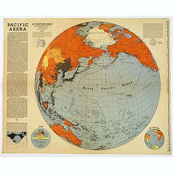
Pacific Arena
1942 FORTUNE MAGAZINE. - Second World War map covering the Pacific regions. Printed as Supplements to 'Fortune' in March 1942
Date: New York, 1942
![America Settentrionale Colle Nuove Scoperte Sin All Anno 1688. . . (together with] America meridionale . . .](/uploads/cache/49063-250x250.jpg)
America Settentrionale Colle Nuove Scoperte Sin All Anno 1688. . . (together with] America meridionale . . .
Gorgeous example of Coronelli's famous four- sheet map of America. One of the best examples of California as an island. The map also includes extensive annotations on the...
Date: Venice, 1690

Americae Nova Descriptio.
Final state. According to Philip Burden, "this scarce map is America's first single-sheet map with decorative borders." A re-issue of the 1614 plate by Pieter v...
Date: Amsterdam, 1652
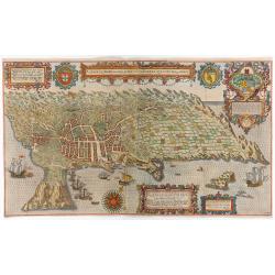
A cidade de Angra na ilha de Iesuxpo da Tercera..
Spectacular perspective view of the harbour and town of Angra on the island of Terceira in the Azores. It was at the time an important port and administrative centre of t...
Date: Amsterdam, 1598
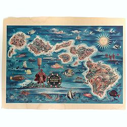
The Dole Map of the Hawaiian Islands.
A terrific, colorful poster of the Hawaiian Islands by Joseph Feher, commissioned for the Hawaiian Pineaple Co. The poster displays all eight of the major islands in the ...
Date: USA, 1950
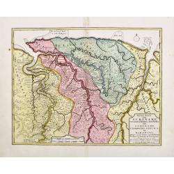
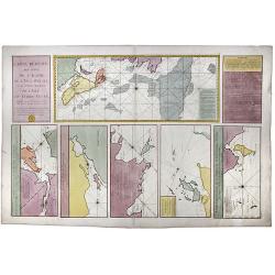
Algemeene kaart van de Colonie of Provintie van Suriname : met de rivieren, districten, ontdekkingen door militaire togten. . .
1740 DE LETH, H. - Large-scale map of Suriname, a record of one of the most important early Jewish communities in the Americas.
Date: Amsterdam, 1740
Nieuwe kaart van Suriname vertonende de stromen en land-streken van Suriname, Comowini, Cottica en Marawini, gelegen in Zuid America op de kusten van Caribana. . .
Decorative full color example of Ottens' map of Suriname. Detailed map of the northeast part of Suriname between Paramaribo, with fort Zeelandia, and Mana.Along the Surin...
Date: Amsterdam, ca. 1713-1718
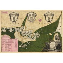
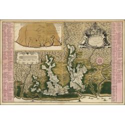
Naaukeurige Platte Grond van den Staat en den Loop van Rio de Berbice Met derzelver Plantagien in de Geoctrojeerde Colonie de Berbice Gelegen. . .
Uncommon large-scale map of Berbice with Rio de Berbice and Rio de Canje, with at the bottom left a list of plantation owners. In the top 3 x 3 coats of arms in cartouche...
Date: Amsterdam, 1740
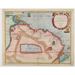
La Guaiane ou Coste Sauvage, autrement El Dorado, et Pais des Amazones…
An extremely rare edition of Du Val's map, separately published by Jollain in 1668, that references the name "El Dorado" in its title. The title translates as f...
Date: Paros, Chez Jollain, 1668
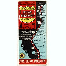
New York - Miami Ocean Highway. Pines to Palms. - Ocean Highway Official Highway Route Approved and Sponsored by the Ocean Highway Association.
Vintage road map showing "The Route of the Experience Motorist" features mileage information in the right margin. Verso features information on cities along the...
Date: Washington, ca. 1947
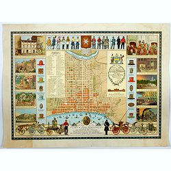
A Map of the City of Philadelphia, showing the Location of the Volunteer Fire Companies. . .
A fine, large pictorial plan of the City of Philadelphia, based on the drawing by Jacob Riegel in 1937, which itself was based on an earlier work dating back to 1794. The...
Date: Philadelphia, 1938
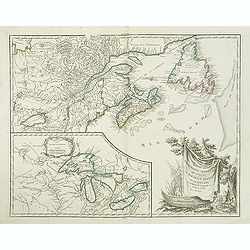
Carte Reduite, des Cotes De L'Acadie, de L'Isle Royale, et de la Partie Meridionale de L'Isle de Terre Neuve.
An important chart of Nova Scotia, southern Newfoundland and the Grand Banks, prepared after Chabert's voyage to Canada to update the French charts of Eastern Canada. It ...
Date: Paris, 1753

Pas kaart vande Zuyd kust van Cuba en van Geheel Jamaica…
A nautical chart covers the southern part of Cuba, Jamaica, the western tip of Hispaniola, and some Honduran coastline. Insets of "Baya Oristan in Yamaica ent Groodt...
Date: Amsterdam, J. van Keulen, 1697-1709
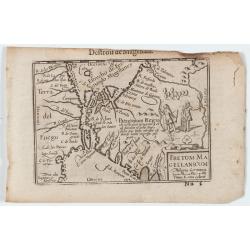
Fretum Magellanicum / Detroit de Magellan.
Early nice map of the South American extremity with the Strait of Magallanes, discovered by Ferdinand Magellan ( c. 1480 – 27 April 1521). Two natives holding a shield an...
Date: Amsterdam, 1606
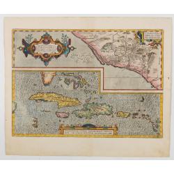
Hispaniolae, Cubae Alliarumique Insularium
Two maps on one sheet: one of the Viceroyalty of Culiacan in Northwestern Mexico and one of the Caribbean. Based on Mercator's 1569 world map, Guttierez' America map of 1...
Date: Antwerp, 1609
Partie de l'Amerique septent? Qui comprend la nouvelle France. . .
A fine copy of this map of New Foundland, Nova Scotia and the course of the St.Lawrence to Lake Ontario in a forth state.An inset shows Bellini's famous and important map...
Date: Paris, 1755-1778
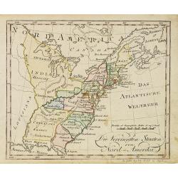
Die Vereinigten Staaten von Nord-Amerika.
Nice little German map of the early United States. The only state shown west of the Appalachian Mountains is Kentucky. Above which is a strangely shaped unnamed region (O...
Date: Augsburg, 1812
