Popular Listings in America

Ca-Ta-He-Cas-Sa-Black Hoof. Principal Chief of the Shawanoes.
Half-length portrait of Catahecassa wearing a dark colored jacked, grey vest, white shirt, and grey head scarf. A wonderful hand colored lithograph of Ca-Ta-He-Cas-Sa-Bla...
Date: Philadelphia, 1837

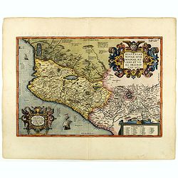
Carte du Mexique et des Etats Unis d'Amérique...
A later edition of De l'Isle's foundation map of 1703, is widely regarded as one of the most influential maps in the history of American Cartography. This updated version...
Date: Paris, 1783

Brasila.
Map of Brazil extending from C. Nasou and Parime Lago to the Mouth of the Rio de la Plata. Oriented with West on top.The cartography of the region is quite primitive. The...
Date: Amsterdam, 1673

Canibales Insulae.
Rare, early Dutch nautical chart of the Caribbean from Puerto Rico southward.
Date: Amsterdam, 1670

Carte Réduite Du Golphe Du Mexique Et Des Isles De L' Amérique..
A well engraved and highly detailed chart prepared by Bellin of the Gulf of Mexico and the Caribbean. In addition to a magnificent title cartouche and a color key to the ...
Date: Paris dated year 17, or 1808
![[ Portraits of Motezuma II and Cortes ].](/uploads/cache/27573-250x250.jpg)
[ Portraits of Motezuma II and Cortes ].
Aquatint depicting two portraits of Motezuma II and Cortes engraved by Gallina. Plate N°63.Montezuma II was trained as a priest and rose to become leader of the Aztecs in...
Date: Milan, 1827
![[View of the Potomac River from Mount Vernon ].](/uploads/cache/27550-250x250.jpg)
[View of the Potomac River from Mount Vernon ].
Aquatint depicting a view of the Potomac River from Mount Vernon engraved by Fumagalli. Plate N°46.From Giulio Ferrario's work Le Costume Ancien et Moderne ou Histoire du...
Date: Milan, 1827

Paraquariae Provinciae Soc. Iesu cum Adjacentibus Novissima...
Between the years of 1609 and 1780, the Jesuits (the Roman Catholic Society of Jesus) established in South America, an autonomous Christian state, on the lands of present...
Date: Augsburg, 1740

Typus Geographicus Chili Paraguay Freti Magellanici &c.
Detailed map covering the southern part of the continent based on the cartography of Delisle and the information gleaned from the voyages of Brouwer, Narbouroug and Beauc...
Date: Nuremberg, 1750

Plan of the Borough of New Rochelle, Westchester Co. N.Y.
Fine lithographed map of the plan of the Borough of New Rochelle. The map provides the names of specific homeowners, as well as information about the occupations and phys...
Date: New York, 1867
![The Coast of New Found Land From Salmon Cove to Cape Bonavista. . . [together with] The Coast of New Found Land from Cape-Raze to Cape St-Francis.](/uploads/cache/40658-250x250.jpg)
The Coast of New Found Land From Salmon Cove to Cape Bonavista. . . [together with] The Coast of New Found Land from Cape-Raze to Cape St-Francis.
Two charts showing the coast of New Found Land from Salmon Cove to Cape Bonavista and from Cape-Raze to Cape St-Francis. With inset chart of Trinity HarborGrierson publis...
Date: Dublin, 1767

A new map of the English Empire in America. . .
This fine English map of eastern North America including Canada engraved by John Harris and first published by Robert Morden. John Senex acquired and made minor alteratio...
Date: London, 1720
![[ Hieroglyph Christian calendar written in an Aztec style ].](/uploads/cache/27593-250x250.jpg)
[ Hieroglyph Christian calendar written in an Aztec style ].
Aquatint depicting Hieroglyph Christian calendar written in an Aztec style engraved by BonattiB. Plate N°84.From Giulio Ferrario's work Le Costume Ancien et Moderne ou Hi...
Date: Milan, 1827
![[ Acrobatic games ].](/uploads/cache/27589-250x250.jpg)
[ Acrobatic games ].
Aquatint depicting acrobatic games engraved by Gallina. Plate N°78.From Giulio Ferrario's work Le Costume Ancien et Moderne ou Histoire du gouvernement, de la milice, de ...
Date: Milan, 1827
![[ Azrec Idols ].](/uploads/cache/27579-250x250.jpg)
[ Azrec Idols ].
Aquatint depicting Aztec idols engraved by Gallina. Plate N°698.From Giulio Ferrario's work Le Costume Ancien et Moderne ou Histoire du gouvernement, de la milice, de la ...
Date: Milan, 1827
![[ Aztec low relief representing ancient warriors ].](/uploads/cache/27577-250x250.jpg)
[ Aztec low relief representing ancient warriors ].
Aquatint depicting an Oaxaca monument representing a warrior engraved by Bonatti. Plate N°67.From Giulio Ferrario's work Le Costume Ancien et Moderne ou Histoire du gouve...
Date: Milan, 1827
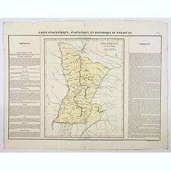
Carte Geographique, Statistique et Historique du Paraguay.
A nice detailed map of Paraguay from Buchon's Atlas Gégraphique Statistique, historique et chronologique des deux Ameriques et des isles adjacentes traduit de l'atlas exé...
Date: Paris, 1825
![[Canadian Indians ].](/uploads/cache/27546-250x250.jpg)
[Canadian Indians ].
Aquatint depicting a group of Canadian Indians engraved by Gallina. Plate N° 33 n°1.From Giulio Ferrario's work Le Costume Ancien et Moderne ou Histoire du gouvernement, ...
Date: Milan, 1827

Stoel des Oorlogs in America Waar in Vertoont Werden Alle Desself Voornaamste Eylande . . .
Large impressive map of the West Indies with the Gulf of Mexico and Florida. The map shows prominently in the center Cuba, Haiti, the Bahamas and Florida, which is here m...
Date: Amsterdam, c. 1720

Plan of the Beekmanton Tarryntown and Ivring. Westchester Co. N.Y.
Fine lithographed map of the plan of the Beekmantown, Tarrytown, and Irving, New York. The map provides the names of specific homeowners, as well as information about the...
Date: New York, 1867

20 small lithographed views of Washington DC and Georgetown.
20 small lithographed town-views of Washington DC and Georgetown, cut out from a larger sheet. Showing the East Front of the Capitol, Treasury, Smithsonian Institute, Pre...
Date: Casimir Bohn, Washington, D.C.: 1849

Cunard Cherbourg-New York.
Original vintage Cunard luxury cruise liner travel poster advertising Cunard Europe to all America fastest ocean service in the world. Stunning design featuring two color...
Date: England, ca. 1930
![[ Regla columnar basalt quarry ].](/uploads/cache/27570-250x250.jpg)
[ Regla columnar basalt quarry ].
Aquatint depicting columnar basalt quarry engraved by Fumagalli. Plate N°60.This common extrusive volcanic rock is used for highway construction, railroad ballast, and ti...
Date: Milan, 1827
![[ Mexican traditional garments ].](/uploads/cache/27592-250x250.jpg)
[ Mexican traditional garments ].
Aquatint depicting Mexican traditional garments engraved by Gallina. Plate N°83.From Giulio Ferrario's work Le Costume Ancien et Moderne ou Histoire du gouvernement, de l...
Date: Milan, 1827
![Canada Creek Falls . . [title in French, English, German & Latin] N°32. Pl. 4.](/uploads/cache/26800-250x250.jpg)
Canada Creek Falls . . [title in French, English, German & Latin] N°32. Pl. 4.
A view of the Canada Creek Falls.From 8e Livraison Amérique Septentrionale - Etat de New York. After Jacques Milbert and lithographed by Dupressoir and figures by V. Adam...
Date: Paris, Bove dirigée par Nöel ainé & Cie, 1892
![[ Gladiators ].](/uploads/cache/27583-250x250.jpg)
[ Gladiators ].
Aquatint depicting gladiators in combat engraved by Gallina. Plate N°73.From Giulio Ferrario's work Le Costume Ancien et Moderne ou Histoire du gouvernement, de la milice...
Date: Milan, 1827
![[ Bread making ].](/uploads/cache/27591-250x250.jpg)
[ Bread making ].
Aquatint depicting a family making bread engraved by Gallina. Plate N°82.From Giulio Ferrario's work Le Costume Ancien et Moderne ou Histoire du gouvernement, de la milic...
Date: Milan, 1827
![[ Chief Regolo ].](/uploads/cache/27567-250x250.jpg)
[ Chief Regolo ].
Aquatint depicts Chief Regolo (also called Cacique) accompanied by his women, who are engraved by Gallina. Plate N°57.Cacique from the taíno word for the pre-Columbian tr...
Date: Milan, 1827

Coast to Coast.
A game board that features a map of the U.S. with a built-in spinner. Players travel a circular track around the map visiting landmarks as they go. A fun way to learn geo...
Date: New York, ca. 1950
![[ William Penn's treaty with the Indians in 1681 ].](/uploads/cache/27555-250x250.jpg)
[ William Penn's treaty with the Indians in 1681 ].
Aquatint depicting William Penn's treaty with the Indians in 1681, after a painting by Benjamin West.William Penn (October 14, 1644 - July 30, 1718) was founder and "...
Date: Milan, 1827
![[ Mechoacan Indians traditional garments ].](/uploads/cache/27594-250x250.jpg)
[ Mechoacan Indians traditional garments ].
Aquatint depicting Mechoacan Indians traditional garments engraved by Gallina. Plate N°85.From Giulio Ferrario's work Le Costume Ancien et Moderne ou Histoire du gouverne...
Date: Milan, 1827
![[Human sacrifice.]](/uploads/cache/27582-250x250.jpg)
[Human sacrifice.]
Aquatint depicting a human sacrifice engraved by Gallina. Plate N°72.From Giulio Ferrario's work Le Costume Ancien et Moderne ou Histoire du gouvernement, de la milice, d...
Date: Milan, 1827
![[ Indian accessories ].](/uploads/cache/27566-250x250.jpg)
[ Indian accessories ].
Aquatint depicting Indian accessories engraved by Gallina. Plate N°49.From Giulio Ferrario's work Le Costume Ancien et Moderne ou Histoire du gouvernement, de la milice, ...
Date: Milan, 1827

Carte Réduite De La Partie Septentrionale De L'' Isle De Terre Neuve..
A well engraved and highly detailed chart, corrected to 1767. Elaborate hand-colored cartouche, rhumb lines.Shows northern part of Newfoundland and southern coast of Labr...
Date: Paris, 1767

Carte Réduite Des Côtes Orientales De L' Amérique Septentrionale Contenant Partie du Nouveau Jersey.. Virginie.. Georgie..
Uncommon chart that extends from Delaware Bay and Philadelphia south through much of Georgia to Island Amelia and St. Johns River. Fleur-de-lis and rhumb lines fill the s...
Date: Paris, 1778

Major Ridge. A Cherokee Chief.
Head and shoulders portrait of Major Ridge,(1771-1839) wearing a blue jacket, gold or yellow vest, white shirt, and black cravat. A Cherokee Chief, who as a Cherokee lead...
Date: Philadelphia, 1837
![[Canadian Indian traditional garments ].](/uploads/cache/27544-250x250.jpg)
[Canadian Indian traditional garments ].
Aquatint depicting Canadian Indian traditional garments engraved by Gallina. Plate N°32.From Giulio Ferrario's work Le Costume Ancien et Moderne ou Histoire du gouverneme...
Date: Milan, 1827

Carte Geographique, Statistique et Historique de l'Amerique Meridionale.
A nice detailed map of South America from Buchon's Atlas Gégraphique Statistique, historique et chronologique des deux Ameriques et des isles adjacentes traduit de l'atla...
Date: Paris, 1825

Nova Virginia Tabula.
A beautifully engraved map, derived from the highly influential map by Captain John Smith in 1612, showing Chesapeake Bay and the surrounding area. The decoration of this...
Date: Amsterdam, J.Meurs, 1671
![[ Hieroglyph representing the Cihuacohuat Goddess ].](/uploads/cache/27578-250x250.jpg)
[ Hieroglyph representing the Cihuacohuat Goddess ].
Aquatint depicting a hieroglyph representing the Cihuacohuat Goddess engraved by DKB. Plate N°68.From Giulio Ferrario's work Le Costume Ancien et Moderne ou Histoire du g...
Date: Milan, 1827
![[ Mexican weapons ].](/uploads/cache/27576-250x250.jpg)
[ Mexican weapons ].
Aquatint depicting an Oaxaca monument representing a warrior engraved by Bonatti. Plate N°66.Oaxaca is the historic home of the Zapotec and Mixtec peoples, and contains m...
Date: Milan, 1827

Carte Geographique, Statistique et Historique du Perou.
A nice detailed map of Peru from Buchon's Atlas Gégraphique Statistique, historique et chronologique des deux Ameriques et des isles adjacentes traduit de l'atlas exécuté...
Date: Paris, 1825
![Posesiones de America : Isla de Cuba. [together with] Isla de Cuba. . .](/uploads/cache/23458-250x250.jpg)
Posesiones de America : Isla de Cuba. [together with] Isla de Cuba. . .
Wall size sea chart and map of land areas showing all of Cuba, part of Florida Keys plus San Adios and Salvador Grande in the Bahamas.Minute topographical, political, and...
Date: Madrid, 1853 / 1851

Carolinae Floridae nec non Insularum Bahamensium cum partibus adjacentibus delinatio ad Exemplar Londinense in lucem edita . . . Ao. 1755.
The German edition of this map of Carolina, Florida, and the Bahama Islands in full original colors. Published in Seligmann's "Sammlung verschiedener auslaendischer ...
Date: Nuremberg, 1755
![Amerique Septentrionale divisée en ses principales parties. . .1692. [California as an Island]](/uploads/cache/27961-250x250.jpg)
Amerique Septentrionale divisée en ses principales parties. . .1692. [California as an Island]
A very good impression of Jaillot's large map of North America, showing California as an Island, based upon Sanson's landmark map of 1656. A first state.The map shows the...
Date: Amsterdam, c.1692
![[ Niagara Falls ]](/uploads/cache/27543-250x250.jpg)
[ Niagara Falls ]
Two aquatints depicting the Horse Shoe Fall (also known as Canadian Falls at the top) and the Fort Schloper Fall (bottom) engraved by Biasolé. From Giulio Ferrario's work...
Date: Milan, 1827
![[ Chief Regolo ].](/uploads/cache/27568-250x250.jpg)
[ Chief Regolo ].
Aquatint depicting chief warriors engraved by G. G. Plate N°58.Cacique from the taíno word for the pre-Columbian tribal chiefs or leaders of the Taino tribes in the Baham...
Date: Milan, 1827
![[ Mexican weapons ].](/uploads/cache/27575-250x250.jpg)
[ Mexican weapons ].
Aquatint depicting Mexican weapons engraved by DKB. Plate N°65.From Giulio Ferrario's work Le Costume Ancien et Moderne ou Histoire du gouvernement, de la milice, de la r...
Date: Milan, 1827

Sabena (USA - NYC).
Sabena Belgian World Airlines poster showing the skyline of New York in abstract style. Published by Rali Brisart in Belgium.La Sabena, acronym for Societé Anonyme Belge...
Date: Brussels, ca. 1970
![Amerique Septentrionale divisée en ses principales parties. . .1685. [California as an Island]](/uploads/cache/60628-250x250.jpg)
Amerique Septentrionale divisée en ses principales parties. . .1685. [California as an Island]
Engraved by Cordier. Spectacular example of Jaillot's map of North America, showing California as an Island, based upon Sanson's landmark map of 1656. This map shows the ...
Date: Paris, 1685
![[Florida Indian cooking ].](/uploads/cache/27561-250x250.jpg)
[Florida Indian cooking ].
Aquatint depicting Florida Indian cooking engraved by Fumagalli. Plate N°54.From Giulio Ferrario's work Le Costume Ancien et Moderne ou Histoire du gouvernement, de la mi...
Date: Milan, 1827
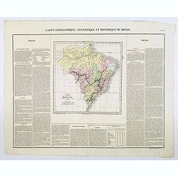
Carte Geographique, Statistique et Historique du Bresil.
A nice detailed map of Brazil from Buchon's Atlas Gégraphique Statistique, historique et chronologique des deux Ameriques et des isles adjacentes traduit de l'atlas exécu...
Date: Paris, 1825
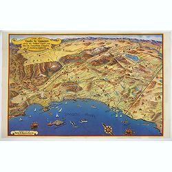
Ride the Roads to Romance along the Golden Coast and thru the Sunshine Empire of Southern California.
Published in 1950 by the Roads to Romance Association to promote tourism in California This striking touring map of Southern California was published in 1950 by the Road...
Date: California, 1950

A new & accurate map of Louisiana, with part of Florida. . .
An English view of North America compiled from available French maps, especially those of Bellin used in Charlevoix's History of New France. English cartographers had lit...
Date: London, 1744

P.les de Virginie.
Attractive copper engraving, depicting a couple of native people of Florida.From the French text edition of Description d'Univers, 1683. by Allain Manneson Mallet (1630-1...
Date: Paris, 1683

(Island of Pearls) Perlarum insula ob unionum copiam sic dicta.
A depiction of Cubagua as the Perlarum Insula (Island of Pearls), with in the foreground, two large ships send dinghies toward busy Native Americans collecting pearl oyst...
Date: Frankfurt, 1594

L'Amerique Septentrionale.
Very rare map, from "Metaphaste Barbao, Descriptio Indiae Occidentalis et America Nova" published by Henrico Verdussen.The map is a copy of Guillaume de L'Isle'...
Date: Antwerp, 1702

Géographie des Plantes Equinoxiales - Tableau physique des Andes et pays voisins. . .
Physical Portrait of the Andes and adjacent lands", organized around the Chimborazo and Cotopaxi volcanoes in Ecuador.With local vegetation is illustrated pictoriall...
Date: Paris, 1805
![Le Isole di Sandwich delineate sulle osservazioni del Cap Cook. [Hawaii]](/uploads/cache/43195-250x250.jpg)
Le Isole di Sandwich delineate sulle osservazioni del Cap Cook. [Hawaii]
FIRST EDITION on laid paper. Cassini’s splendid map depicts the Sandwich Islands, the old name for the Hawaiian Islands, at the end of the eighteenth century. The splendi...
Date: Rome, 1798

Guaranty Trust Company of New York. Emprunt national 6%.n Souscrivez.
Very decorative propaganda poster with design by Mark All of Paris for "Guaranty Trust Company of New York", a JPMorgan Chase predecessor in order to promote th...
Date: Paris, 1918

Avantures du Sr. C. Le Beau, avocat en parlement ou Voyage curieux et nouveau parmi les Sauvages de l'Amérique Septentrionale. Dans lequel on trouvera une Description du Canada… Ouvrage enrichi d'une Carte et des figures necessaires.
A description of Huron, Iroquois, and Algonquin customs, written in charming style and based, the Author claims, on observations made on a trip to America in 1729." ...
Date: Amsterdam, 1738
![Pisces in mari alati [flying fish attack]](/uploads/cache/48527-250x250.jpg)
Pisces in mari alati [flying fish attack]
Flying fish attacking a Portuguese ship in the West Indian Waters.Read more about "Les Grand Voyages" by Theodore De Bry [+]
Date: Frankfurt, 1594

Bison Iubatus.
Etching of a bison by Leendert Brasser (1727 - 1793) after a painting of the Dutch artist Gerrit van den Heuvel.An early portrait of a bison, etched by Leendert Brasser (...
Date: Rotterdam, 1766-1793

Forest scene on the Tobihanna Alleghany Mountains.
Original aquatint engraving for Travels in the Interior of North America between 1832-34 . Engraved by L.Weber. The finest work on American Indian life and the American F...
Date: London/Paris/Coblenz, 1839

Carte Geographique, Statistique et Historique de Buenos-Ayres.
A nice detailed map of what is today northern Argentina (Rep. of Buenos Ayres or the United Provinces of South America) from Buchon's Atlas Gégraphique Statistique, histo...
Date: Paris, 1825
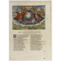
Americae Retectio (Allegory of the Discovery of America)
Allegorical scene commemorating the discovery of America. The main image shows Neptune, supporting a Globe, flanked by Flora-representing Florence, and Janus-representin...
Date: Frankfurt, 1594

Nieuwe Wassende Graade Zee Kaart over de Spaanse Zee Vant Kanaal tot 't Eyland Cuba In Westindia.
Rare two-sheet blue-back sea chart of the Atlantic and Eastern part of North America., published by Gerard Van Keulen. The map extends from the latitude of Newfoundland a...
Date: Amsterdam, ca. 1728-1751

ETATS-UNIS DE L'AMÉRIQUE SEPTENTRIONALE Avec LES ISLES ROYALE, DE TERRE NEUVE, DE S.T JEAN, L'ACADIE, &c. 1785. Supplement a l'Atlas de M. Robert de Vaugondy a Paris Ches Boudet Ingenieur du Roi.
A map of the eastern United States with "Supplément à l'atlas de M. Robert de Vaugondy à Paris chez Boudet Imprimeur du Roi", in place of the attribution to Del...
Date: Paris, 1785

America settentrionale. . .
Rare map of North America drawn directly from the work of Nicholas De Fer and N. Sanson's famous map of 1650. The map is engraved by Antonius Donzel Gallus.With open Grea...
Date: Napels, 1766

A Hysterical Map of the Yellowstone Park. . .
A funny 1936 pictorial map of Yellowstone Park, that was 'hatched and scratched' by the American printer and humourist Jolly Elmer Lindgren. This wonderful map covers the...
Date: Spokane, 1936
Hispaniae novae sive magnae recens et vera descriptio. 1579
This was the standard map of the area for a generation, copied by De Bry, Quad and Hondius. Even though Herrera (Spain's Royal Cosmographer) and Wytfliet worked 20 years ...
Date: Antwerp, 1598
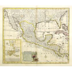
A new and accurate map of Mexico or New Spain with California New Mexico . . .
With inset of Galapagos islands. A wonderfully engraved map showing the entire American South from Carolina to California, as well as all of Mexico and Central America. A...
Date: London, 1747
Islands in the Atlantic.
Decorative steel engraved map of Islands showing the Azores, Madeira, Bermuda, the Canaries and the Cape Verdes. Interlocking border design. Taken from "The illustra...
Date: London, ca. 1851
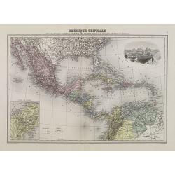
Amérique Centrale.
Decorative map of Central America from Géographie Universelle, Atlas Migeon. With an inset map of the Isthmus of Panama lower left corner and a panoramic view of Mexico C...
Date: Paris, 1874

Carte de la Nouvelle France, ou se voit le cours des Grandes Rivieres de S. Laurens & de Mississipi..
Derived from de Fer's 1718 map, from west of the Mississippi it contains a mass of inland detail with notes and vignettes of the indigenous peoples and fauna of North Ame...
Date: Amsterdam, 1720

Americae Nova Tabula.
The delineation of the coast and the nomenclature on both the Pacific and Atlantic coasts are basically Spanish in origin and follow the maps of Ortelius and Wytfliet. To...
Date: Amsterdam, 1645
![[ View of an inn and a horse carriage. ].](/uploads/cache/27552-250x250.jpg)
[ View of an inn and a horse carriage. ].
Aquatint depicting a view of an inn and a horse carriage engraved by Fumagalli. Plate N°44.From Giulio Ferrario's work Le Costume Ancien et Moderne ou Histoire du gouvern...
Date: Milan, 1827
![[The French left in Fort Charles suffer the scarcity of provisions. (Virginia]](/uploads/cache/48529-250x250.jpg)
[The French left in Fort Charles suffer the scarcity of provisions. (Virginia]
An Indian town visited by the French of Charlesfort in search for food. After a drawing by LeMoyne. Charlesfort-Santa Elena is on what is now Parris Island, South Carolin...
Date: Frankfurt, 1594

Rerum per octennium in Brasilia Et alibi nuper gestarum, Sub Praefectura Illustrissimi Comitis I. Mauritii, Nassoviae, (...) Historia.
First edition. Commissioned by Johan Maurits van Nassau (governor of Brazil between 1636-1644 and founder of "Mauritsstad" (present-day Recife)) and illustrated...
Date: Amsterdam, J. Blaeu, 1647
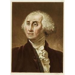
Portrait de George Washington.
Portrait of the first president of the United States of America.From Giulio Ferrario's work Le Costume ancien et moderne ou histoire du gouvernement, de la milice, de la ...
Date: Milan 1827
