Browse Listings
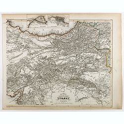
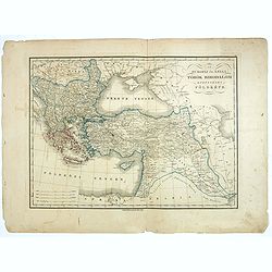
Specialkarte der Asiatischen Turkey : 1. Blatt Anadoli (Klein - Asien)
Steel engraved map of western part of Turkey, engraved by Ifslieb and J. Grassl.
- $75 / ≈ €64
Date: Hildburghausen, 1860
![[Europe depicted as a Queen]](/uploads/cache/41499-250x250.jpg)
[Europe depicted as a Queen]
Among the most striking of early cartographic curiosities is Europe regina or Queen of the world first published by Johannes Bucius' and populized by Sebastian Münster.....
Date: France, ca. 1860
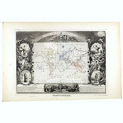
Planisphère.
One of the last decorative maps of the area. In side panels representations of the four seasons. In original out line color, from his "Atlas Universel Illustré"...
Date: Paris, 1845-1860

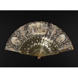
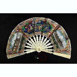
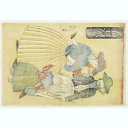
A fan combining views of Hong Kong (right), Canton (center), and Macau.
The fan shows nice images of Macau, Hong Kong and Canton on onside and on verso a garden with 45 characters welcoming a rider on his white horse. Their clothes are height...
Date: China, ca. 1850-1860
Country pleasures.
Folding fan made of a double sheet of lithographed paper, enhanced with gouache and watercolor, with a decoration of three cartouches with gallant scenes of French countr...
Date: France, ca. 1850-1860
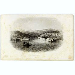
Sebastopol.
Steel engraving of the harbour at Sebastopol in the Ukraine published by James Virtue around 1860.
- $45 / ≈ €38
Date: London, 1860
A fan combines views of Hong Kong (right), Canton (left), China, ca 1850-1860.
The fan shows nice images of Hong Kong and Canton on onside and on verso a garden with 39 characters welcoming a rider on his white horse. Their clothes are heightened in...
Date: China, ca. 1850-1860
Frefser.
Etching by Jos Ströber after a design of Loder.
- $75 / ≈ €64
Date: Germany, ca. 1860
Plan de la rivierè de Saigon et de ses affluents dressé par ordre de M. le capitaine de vaisseau d'Ariès, gouverneur de Saigon, d'après les documents fournis par MM. Lespès. . .
A huge folded map the Saigon river prepared after Léo de Lespès, Rieunier Narac. Inset map of "Carte de Banc de Corail, levée d' après les ordres de Mr. le Capta...
- $750 / ≈ €635
Date: St Joseph, Saigon, after 1860
V. Compartimento Grossetano. . .
Very finely engraved and detailed map of Tuscany, centered on Grosseto. The island of Elba in left part.. In the corners insets of Sovana, Massa, Piombino, Orbetello and ...
- $200 / ≈ €169
Date: Rome, 1860
Carta degla Stati Estensi avanti il domino dei Romani Sotto Il governo dei Medesimi.
Very finely engraved and detailed map of the Duchy of Lucca before the dominion of the Romans under the rule of the same and in the Middle AgesWith a key on the right par...
- $200 / ≈ €169
Date: Rome, 1860
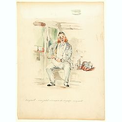
Very well . . . mon petite necessaire de voyage . . . very well.
A delightful water color of a portly, jolly looking fellow with braces and a blue checked jacket, settling down to a long journey. He is addressing his remarks to his ess...
- $100 / ≈ €85
Date: Paris, 1860
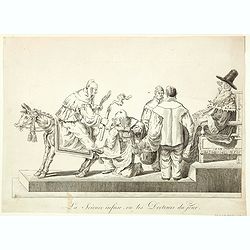
La Science infuse, ou les Docteurs du jour.
Demonstrating the innate knowledge of science, a man is sitting backwards on a donkey holding its tail in one hand and a candle in the other, another man is about to admi...
Date: Paris, 1860
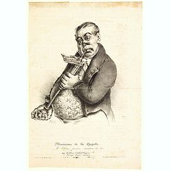
Musicien de la Chapelle. Mr. Lebeau premier trombone du Roi.
A humorous cartoon showing a rather surprised looking Mr. Lebeau - the portly, premier trombone player to the French king, 'playing' a clyster, with tube in mouth, and on...
Date: Paris, ca 1860

Europish Turkije, Griekenland Jonische Eilander.
Uncommon map of Greece, Lithography by J.H. van Weijer, published in Atlas der geheele Aarde in 24 kaarten. With colored key to processions.
- $10 / ≈ €8
Date: Groningen, ca. 1860
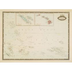
Les divers archipels de L'Oceanie.
Very detailed map from Atlas Sphéroïdal & Universel de geographie , Prepared by F.A.Garnier and edited by Jules Renouard, rue de Tournon, Paris. Uncommon map with d...
- $150 / ≈ €127
Date: Paris, 1861
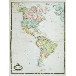
Amérique. . .
Very detailed map from Atlas Sphérodidal & Universel de géographie , Prepared by F.A.Garnier and edited by Jules Renouard, rue de Tournon, Paris. With decorative ti...
- $300 / ≈ €254
Date: Paris, 1861
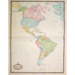
Amérique..
Very detailed map from Atlas Sphéroïdal & Universel de géographie. Prepared by F.A.Garnier and edited by Jules Renouard, rue de Tournon, Paris. With decorative tit...
- $175 / ≈ €148
Date: Paris, 1861
![Gaikoku jinbutsu - Amerika, Furansu. [People from foreign lands - Americans, French ]](/uploads/cache/32196-250x250.jpg)
Gaikoku jinbutsu - Amerika, Furansu. [People from foreign lands - Americans, French ]
Yokohama wood block print showing two women talking with each other. To the right two men in military uniforms. Utagawa, Yoshitora, was a Japanese wood cut engraver activ...
- $1500 / ≈ €1271
Date: Yokohama, 1861
Amerikajin yūkiō. (AMERIKAZIN??) (American family with children)
Wood block print by Utagawa Yoshifuji (1828-1887) of American parents with two children. Edited by Aito and signed : Ipposai Yoshifuji ga.
- $1500 / ≈ €1271
Date: Yokohama, February, 1861
Yokohama Shokan Furansujin umanori no zu. (Picture of a French lady on horse of a trading company in Yokohama)
A Frenchman and a French lady from the Trading Company in Yokohama, design by Utagawa Sadahide (1807-1873) and published by Daikokuya Heikichi and engraved by Hori Take....
- $1350 / ≈ €1143
Date: Yokohama, ca. 1861
![[Ships at sea]](/uploads/cache/08213-250x250.jpg)
[Ships at sea]
Attractive lithography showing Dutch vessels off the Dutch coast, by F.H.Weissenbruch after a painting by L.Meijer. Published in Kunst Kroniek .
Date: The Hague, 1862
![Red Sea - Strait of Jubal.. [2838]](/uploads/cache/23496-250x250.jpg)
Red Sea - Strait of Jubal.. [2838]
Large chart focused on the Strait of Jubal in the Gulf of Suez. With the Juzur Tawilah Islands at the center and an inset plan of the Tur Harbour (At Tur, South Sinai) o...
- $500 / ≈ €424
Date: London (1853) corrected for 1862
Militairy manuscript map of the end of Yangzi River across Shanghai, Jiangsu, and Zhejiang areas, with 3 red seals of the Ever-Victorious Army.
In the lower left corner, an inset plan of Songjiang District with Shanghai is shown with a grid, and the area is divided with red dotted border lines.The map has three r...
Date: China, ca 1862
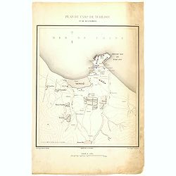
Plan de Camp de Tché-Fou et de ses environs.
A rare and detailed plan of Chefoo, which was a treaty port in Shantung province, near today's Yantai. Plate IV from "Atlas de l'expédition de Chine en 1860: rédig...
- $300 / ≈ €254
Date: Paris, 1862
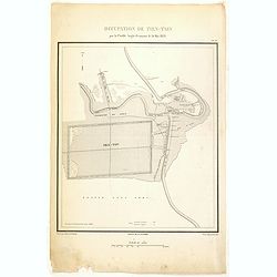
Occupation de Tien-Tsin par la Flottille Anglo-Française le 26 Mai 1859.
Plate III from "Atlas de l'expédition de Chine en 1860: rédigé au dépôt de la guerre d'après les documents officiels, étant directeur le général Blondel, so...
- $250 / ≈ €212
Date: Paris, 1862
![[Lady with a basket.]](/uploads/cache/37928-250x250.jpg)
[Lady with a basket.]
Lithography by Felix after a painting by Isaac Israel. Printed by J.D. Steurwald.
Date: The Hague, Amsterdam, 1862
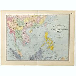
Carte de l'Asie orientale comprenant l'empire chinois le Japon les états de l'Indo-Chine et le grand archipel d'Asie ou Malaisie.
Detailed map of Malaysia, Thailand, China, Taiwan, and good detail in Philippines. Lower part of a 2-sheet map.
Date: Paris, 1862
Atlas Sphéroïdal et Universel de Géographie. Dressé à l'aide des documents officiels, récemment publiés en France et à l'étranger.
World atlas divided in 6 sections : World and spheres, Europe, Asia, Africa, America and Oceania, Illustrated with 63 maps in original colors, 22 double-page maps and 41 ...
Date: Paris, Veuve Jules Renouard, 1862
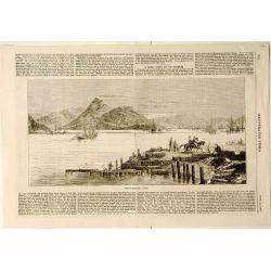
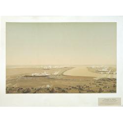
View of Nagasaki, Japan.
A panoramic view of Nagasaki harbour from the Illustrated Times of November 28th., 1863. With accompanying one column descriptive text on verso of Nagasaki.
- $100 / ≈ €85
Date: London, 1863
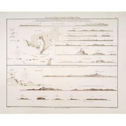
Küstenansichten von Japan bis Capstadt und St. Helena in 5 Blättern.
Prepared by Officer S.M.S. Arcona during the German expedition of 1860-1861 to South East Asia. Lithographed by Lippold and printed by C.Ulrich of Berlin. Sheet 2 from a ...
Date: Berlin, 1863

Plan de la rade de Macao (chine) Levé d'après les ordres mr. Rocquemaurel.
Very detailed chart of Macao and several of the surrounding Islands, and features numerous depth soundings throughout. Prepared by captain, Gaston de Rocquemaurel. Logo o...
Date: Paris, c.1856 / 1863

Great Elephant Imported from Central India.
This is a piece belonging to Misemono-e of animals (literally, pictures of show animals). The giant elephant brought in from India in 1863 was accepted by Japanese people...
- $3000 / ≈ €2541
Date: Yokohama, 1863
![[Lot of 9 maps] Plan général de Sébastopol avec indication des travaux du siege et de la defense au 28 mars - 9 avril 1855. Feuille 10. xiii](/uploads/cache/33907-250x250.jpg)
[Lot of 9 maps] Plan général de Sébastopol avec indication des travaux du siege et de la defense au 28 mars - 9 avril 1855. Feuille 10. xiii
A group of nine (of 14) very rare panoramic town-plans of the siege of Sebastopol or maps of the Crimea. In lower margin : "Gravé au Dépôt topographique de la Gue...
Date: St. Petersburg, N. Thieblin, 1863
![[Macaire] Exploitation de l'amitié. Mon cher Alphonse... (Plate 58)](/uploads/cache/17387-250x250.jpg)
[Macaire] Exploitation de l'amitié. Mon cher Alphonse... (Plate 58)
Macaire personified the clever businessman, who was willing at any time to throw moral and ethical principles overboard for a quick buck. His personality fitted exactly t...
- $175 / ≈ €148
Date: Paris, 1864
![[Macaire] Abus de l'article 214 du code civil. Madame mon épouse... (Plate 50)](/uploads/cache/17389-250x250.jpg)
[Macaire] Abus de l'article 214 du code civil. Madame mon épouse... (Plate 50)
Macaire personified the clever business man, who was willing at any time to throw moral and ethical principles overboard for a quick buck. His personality fitted exactly ...
Date: Paris, 1864
![[Macaire] Pensionnat Robert-Macaire. Mr le professeur. . . (Plate 4)](/uploads/cache/17390-250x250.jpg)
[Macaire] Pensionnat Robert-Macaire. Mr le professeur. . . (Plate 4)
Macaire personified the clever businessman, who was willing at any time to throw moral and ethical principles overboard for a quick buck. His personality fitted exactly t...
Date: Paris, 1864
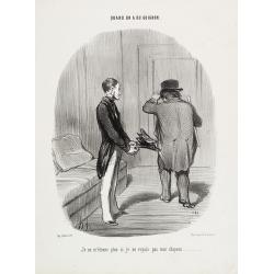
Quand on a du guignon. Je ne m'étonne plus si jevoyais pasmon chapeau . . .
Published by Bauger, rue du Croissant 16 (lower left). Printed by d'Aubert & Cie at Aubert, Place de la Bourse, Paris Text written by Alphonse Jean LAURENT-JAN (1808...
- $250 / ≈ €212
Date: Paris, 1864
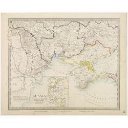
Russia in Europe Part VIII with index map.
Very detailed steel engraved map of the region north of the Black Sea, Podolia, Bessarabia, Kherson, Iekaterinoslav, Taurida, Krimea. Relief shown by hachures.The map is ...
- $150 / ≈ €127
Date: London, Edward Stanford, 1864

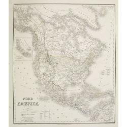
Kiepert's Physikalische Wandkarten. VI. Nord-America.
Large folding school wall map of North and Central America printed in chromo-lithography. Published by Dieter Reimer and printed by Leopold Kraatz in Berlin. Three inset...
Date: Berlin, Dieter Reimer, 1864
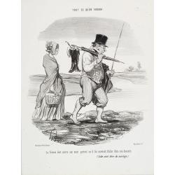
Tout ce qu'on voudra. La femme doit suivre son mari...
TOUT CE QU'ON VOUDRA. (As you like it). This series consists of 94 lithographs published between March 28,1847 and November 30, 1852 in the Charivari. Some of the plates ...
- $360 / ≈ €305
Date: Paris, 1864
Az Europai és Asiai Torok Birodalom Kozonséges Foldképe
Hungarian map of Turkey, including Greece, Cyprus, etc.
- $150 / ≈ €127
Date: Pesten, 1864
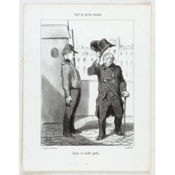
Tout ce qu'on voudra. Jeune et vieille garde...
TOUT CE QU'ON VOUDRA. (As you like it). This series consists of 94 lithographs published between March 28, 1847 and November 30, 1852 in the Charivari. Some of the plates...
- $150 / ≈ €127
Date: Paris, 1864
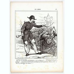
En Chine.
From the series "Caricatures du Prussien - Guerre des Duchés". Lithographed by Julés Pelcoq.
Date: Paris, 1864
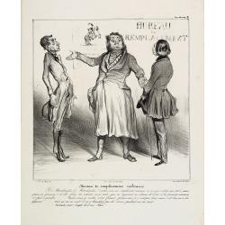
Bureau de remplacemens militaires. Y a Marchandise …(Plate 38)
Macaire personified the clever business man, who was willing at any time to throw moral and ethical principles overboard for a quick buck. His personality fitted exactly ...
Date: Paris, 1864
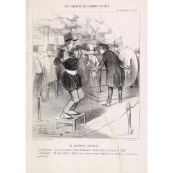
Les plaisirs des Champs-Elysées. Un guerrier electrisé. Le Physicien: tel est…
Published by Bauger, rue du Croissant 16 (lower left). Printed by Imprimeurs d'Aubert & Cie at Aubert, Place de la Bourse. Text was written by Alphonse Jean LAURE...
Date: Paris, 1864
![[Louis-Philippe teaching geography and mathematics in Reichenau, Switzerland]](/uploads/cache/47439-250x250.jpg)
[Louis-Philippe teaching geography and mathematics in Reichenau, Switzerland]
Lithograph by Chrétien after painting by David showing Louis-Philippe (1773-1850) the last king of France (1830-1848), in Switzerland teaching geography and mathematics ...
- $400 / ≈ €339
Date: Paris, 1864
Dutch landscape.
Attractive lithography showing a typical Dutch landscape, lithographed by F.H.Weissenbruch after a painting by W.Roelofs. Published in Kunst Kroniek.
- $50 / ≈ €42
Date: The Hague, 1865
Attaque & prise des forts du Pei-Ho Le 21 Août 1860, par les troupes Françaises et Anglaises.
In 1860, an Anglo-French force gathered at Hong Kong and then carried out a landing at Pei Tang on August 1, and a successful assault on the Taku Forts on August 21.This ...
- $500 / ≈ €424
Date: Paris, ca.1865
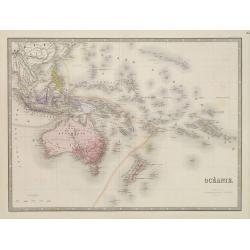
Océanie.
Detailed map of Australia, New Zealand, Indonesia and the Pacific. With a color key indicating English, French, Dutch, Spanish and Portuguese possessions in the region. F...
- $100 / ≈ €85
Date: Paris, 1865
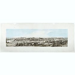
Widok Krakowa od Podgonza.
Bird's-eye view of Krakow city, with underneath the names of thirteen important buildings. Lithographed by J.Brydak after a photo by W. Rzewuskriego. Published by Czasu W...
- $750 / ≈ €635
Date: Krakow, ca. 1865
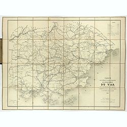
Carte routière et administrative du département du Var dressée sous l'administration et l'approbation de M. Montois, officier de la légion d'honneur, préfet , par J.B CHABET.
Folding-map of the Maritime Alps, and the Mediterranean coastline of Fréjus, Ramatuelle, St Tropez, Toulon. Engraved by Erhard, geographer and engraver (1821-1880) at th...
- $125 / ≈ €106
Date: Paris, 1865
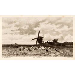
Dutch windmill with sheeps.
Attractive lithography showing a typical Dutch windmill with sheep's on foreground, lithographed by F.H.Weissenbruch after a painting by Jan van Lokhorst. Published in Ku...
- $60 / ≈ €51
Date: The Hague 1866
![(2 charts of Shri Lanka) Mer des Indes - Ile de Ceylan - Partie Nord. Détroit de Palk et Golfe de Manaar.. [with] Partrie Sud...](/uploads/cache/23493-250x250.jpg)
(2 charts of Shri Lanka) Mer des Indes - Ile de Ceylan - Partie Nord. Détroit de Palk et Golfe de Manaar.. [with] Partrie Sud...
Two very large charts representing the northern and southern part of Sri Lanka and giving details about the Indian seacoast around the Gulf of Mannar and the Palk Strait....
- $750 / ≈ €635
Date: Paris, 1866

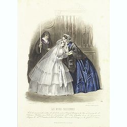
Paris fashion plate 577.
From Les Modes Parisiennes. Underneath the print are the names of the shops where the clothing's, perfumes, porcelains, flowers, etc., depicted in the engraving, are to b...
- $40 / ≈ €34
Date: Paris, 1866
Paris fashion plate. (584)
From Les Modes Parisiennes. Underneath the print are the names of the shops where the clothing's, perfumes, porcelains, flowers, etc., depicted in the engraving, are to b...
- $30 / ≈ €25
Date: Paris, 1866

Paris fashion plate. (120)
From Les Modes Parisiennes. Underneath the print are the names of the shops where the clothing's, perfumes, porcelains, flowers, etc., depicted in the engraving, are to b...
- $25 / ≈ €21
Date: Paris, 1866
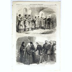
The Prince visiting the foundling hospital. / The Prince visiting the Metropolitan Archbishop.
Two engravings shown Albert Edward the Prince of Wales visiting Moscow from the Illustrated London News.
- $10 / ≈ €8
Date: London, 1866
Carta del Gran Banco de Bahama parte de la Isla de Cuba y Costa de la Florida.
A large marine chart, engraved by Juan Noguera and C.Marquerie, produced by the Direccion de Hydrografia, under the direction of Jose de Quesada, who was the then chief o...
- $1750 / ≈ €1482
Date: Madrid, 1858-1866
Nord America mit Westindien. . .
A superbly engraved and colored map of North America and the West Indies with a host of place names and meticulously rendered topography.Includes an inset of the Aleutian...
Date: Weimar, 1867
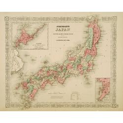
Johnson's Japan Nippon, Kiusiu, Sikok, Yesso. . .
A detailed steel-engraved map of Japan with inset maps of Yes and the Japanese Kuriles and Bay of Nagasaki. The map shows the island Argonaut labeled as Takashima (Ulleun...
- $175 / ≈ €148
Date: New York, 1867

NEWTON'S New and Improved TERRESTRIAL GLOBE Accurately delineated from the observations of the most esteemed NAVIGATORS AND TRAVELLERS to the Present Time. . .
A very impressive Victorian 20-inch Library globe is showing the "Gulf of Corea."On an exceptionally carved mahogany tripod stand with scrolling acanthus legs t...
Date: London, January 1, 1867
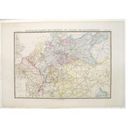
Nouvelle carte des routes de poste de l'Allemagne.
Large post road maps map of Germany, Poland, Austria, Franc, Switzerland, Austria and the Low Countries published by A. Logerot and engraved by C.Dyonnet.The mapsmakes di...
- $350 / ≈ €296
Date: Paris, A. Logerot, c.1867
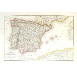
Carte géographique, physique et politique des royaumes d'Espagne et de Portugal indiquant les chemin fer en exploitations, ceux en cours d'éxécutions
Very large, highly detailed and uncommon map of Spain, Portugal and the northern coast of Africa. The map shows according to the title: rail roads, main interregional rou...
Date: Paris, c.1867

Carte générale de L'Empire Ottoman en Europe et en Asie dressée par Henri Kiepert . . .
Large School wall map of Turkish Empire printed in chromo-lithography. Published by Dieter Reimer and printed by Ferdind Barth in Berlin. This rare map has two insets in ...
Date: Berlin, Verlag von Dietrich Reimer, 1867
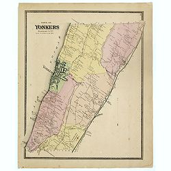
Town of Yonkers Westchester Co. NY
Fine lithographed map of the town of Yonkers. The map provides the names of specific homeowners, as well as information about the occupations and physical locations of th...
Date: New York, 1867
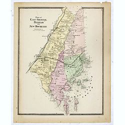
Plans of East Chester Pleham and New Rochelle. Westchester Co.
Fine lithographed map of East Chester Pelham and New Rochelle. The map provides the names of specific homeowners, as well as information about the occupations and physica...
Date: New York, 1867
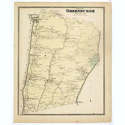
Town of Greenburgh.
Fine lithographed map of the town of Greenburgh. The map provides the names of specific homeowners, as well as information about the occupations and physical locations of...
Date: New York, 1867
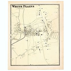
White Plains.
Fine lithographed map of White Plains. The map provides the names of specific homeowners, as well as information about the occupations and physical locations of the vario...
Date: New York, 1867
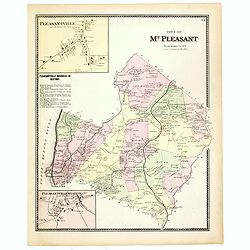
Town of Mt Pleasant. Westchester Co. NY.
Fine lithographed map of the town of Mt Pleasant. The map provides the names of specific homeowners, as well as information about the occupations and physical locations o...
Date: New York, 1867
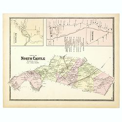
Town of North Castle.
Fine lithographed map of the town of North Castle. The map provides the names of specific homeowners, as well as information about the occupations and physical locations ...
Date: New York, 1867
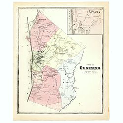
Town of Ossining. Westchester Co. NY.
Fine lithographed map of the town of Ossining. The map provides the names of specific homeowners, as well as information about the occupations and physical locations of t...
Date: New York, 1867
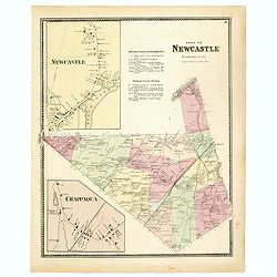
Town of New Castle. Westchester Co. NY.
Fine lithographed map of the town of New Castle. The map provides the names of specific homeowners, as well as information about the occupations and physical locations of...
Date: New York, 1867
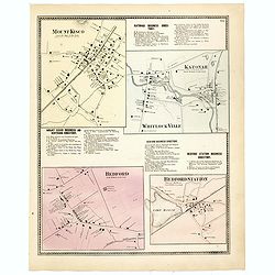
Mount Kisco / Bedford / Katonah / Bedford Station.
Fine lithographed map of Mount Kisco / Bedford / Katonah / Bedford Station. The map provides the names of specific homeowners, as well as information about the occupation...
Date: New York, 1867

Plan of Yonkers Town of Yonkers Westchester Co. N.Y. . . .
Fine lithographed map of Yonkers, New York. The map provides the names of specific homeowners, as well as information about the occupations and physical locations of the ...
Date: New York, 1867

Plan of the Borough of New Rochelle, Westchester Co. N.Y.
Fine lithographed map of the plan of the Borough of New Rochelle. The map provides the names of specific homeowners, as well as information about the occupations and phys...
Date: New York, 1867

Plan of the Beekmanton Tarryntown and Ivring. Westchester Co. N.Y.
Fine lithographed map of the plan of the Beekmantown, Tarrytown, and Irving, New York. The map provides the names of specific homeowners, as well as information about the...
Date: New York, 1867
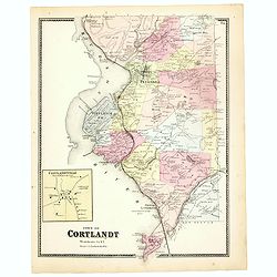
Town of Cortlandt.
Fine lithographed map of the town of Cortlandt. The map provides the names of specific homeowners, as well as information about the occupations and physical locations of ...
- $90 / ≈ €76
Date: New York, 1867
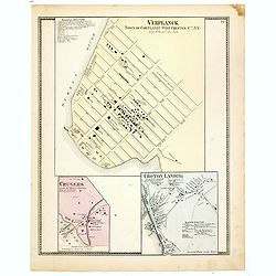
Town of Verplanck / Crugers / Croton Landing.
Fine lithographed map of the town of Verplanck / Crugers / Croton Landing. The map provides the names of specific homeowners, as well as information about the occupations...
- $90 / ≈ €76
Date: New York, 1867
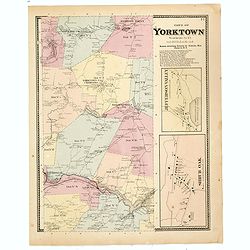
Town of Yorktown.
This is a fine lithographed map of Yorktown. The map provides the names of specific homeowners, as well as information about the occupations and physical locations of the...
- $90 / ≈ €76
Date: New York, 1867