Browse Listings
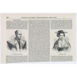
Japanese Sketches.
Two woodcut engravings illustrating a Japanese Gentleman and a Japanese Lady. Included in Ballou's Pictorial.The 1840s~50s saw the rapid growth in popularity of the illus...
- $25 / ≈ €21
Date: Boston, 1856
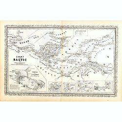
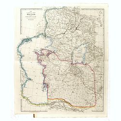
Chart of the Baltic from admiralty & Russian surveys.
Uncommon map of the Baltic Sea and adjacent countries (Denmark, Sweden, Finland, Estonia, Latvia, Lithuania, Poland, Germany) with five vignettes to illustrate the respec...
- $300 / ≈ €254
Date: Pennsylvania, ca. 1856
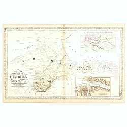
A Complete Map of the Crimea Showing the Military and Carriage Roads with Distances from Various Points of the Western Coast From English & Russian Surveys. . .
Uncommon map of Crimea with (inset maps) Sebastopol Harbor, and Map Showing the relative Position of the Crimea with the Seat of War. From Desilver's "A New Universa...
- $300 / ≈ €254
Date: Pennsylvania, ca. 1856
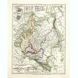
Das Europäische Russland nebst den asiatischen Provinzen diesseit des Ural. 1849.
Detailed map of Russia, with inset plans of St. Petersburg and Moscow with extensive key to the different provinces. The map was according to a text revised in 1856.From ...
Date: Hildburghausen / Philadelphia 1856
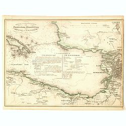
Kriegs- und Spezialkarte vom Finnischen Meerbusen von Kronstadt bis St. Petersburg 1856.
Interesting and detailed map with Kronstadt on the left and St. Petersburg on the right. In the center is information about the war and the listing of some major monument...
- $40 / ≈ €34
Date: Hildburghausen, 1856
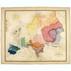
Ethnographic map of Europe by dr. Gustaf Kombst.
Original steel engraving with original hand coloring. A map showing the various ethnicities across Europe with a color key, according to Dr. Gustaf Kombst, published by A...
Date: William Blackwood and Sons, Edinburgh & London, 1856
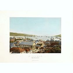
St. Thomas (parti af Byen og Havnen).
A beautiful view of the harbour on the island St. Thomas. This view shows much of the town, bay and surrounding area. One of a series of six lithographs of St. Thomas pro...
Date: Copenhagen, Baerentzen Co, 1856
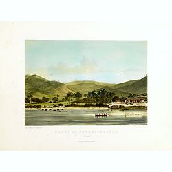
Parti ved Frederikssted (St. Croix).
Early town-views of the small town of Frederiksted on the island of St. Croix. This view shows much of the harbor and a portion of the town's waterfront. one of a series ...
Date: Copenhagen, Baerentzen / Co, 1856
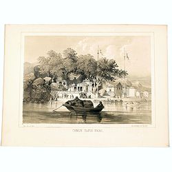
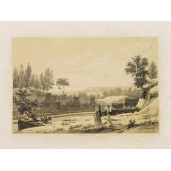
Chinese Temple, Macao.
A pleasant view of the important Chinese Temple in Macao, taken from the water with a junk in the foreground and many sampans and junks moored in front of it, with visito...
- $75 / ≈ €64
Date: Philadelphia, 1856
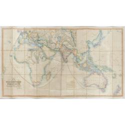
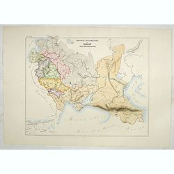
The Pathways of Empire Delineated: Map Showing The Steam Comunication And Overland Routes between England, India, China & Australia…
An illuminating and attractive map that illustrates one of the foundations of British imperial power--the key trade routes by both land and sea between England and its fa...
Date: London, 1856
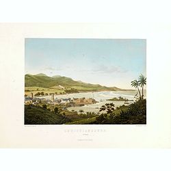
Christianssted. (St.Croix).
A beautiful view of the small town of Christiansted on the island of St. Croix. This view shows much of the harbour and a portion of the town's waterfront. one of a serie...
- $900 / ≈ €762
Date: Copenhagen, Baerentzen & Co, 1856
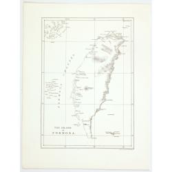
The island of Formosa.
A small, but historically important map of Taiwan (the first American lithograph of Taiwan) made by the American Commodore Matthew C. Perry and published by Ackerman. The...
Date: New York, 1856
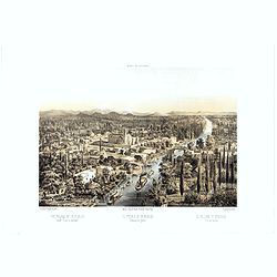
The Bucareli Promenade - Paseo de Bucareli - Promenade de Bucareli.
Lithographed plate of the Bucareli Promenade of Mexico City. The plate has caption title in English, Spanish and French, from the rare publication MEXICO Y SUS ALREDEDORE...
Date: Mexico, Establecimiento Litografico de Decaen, 1855-1856

Provincie Noord-Braband. / Breda, de Langstraat. . .
Decorative and uncommon custume plate lithographed by R. de Vries and published by Frans Buffa & Zonen in Amsterdam. A group of 4 women from the area of Baronie van B...
Date: Amsterdam, 1857

Provincie Noord-Braband.
Decorative and uncommon costume plate lithographed by Desguerrois & Co. and published by Frans Buffa & Zonen in Amsterdam. 12 illustrations of Brabant costumes: 1...
Date: Amsterdam, 1857
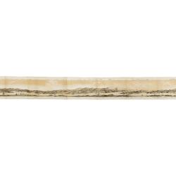
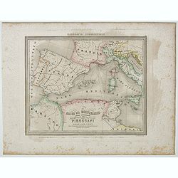
Panorama della Costa e delle Isole di Dalmazia nei viaggi dei piroscafi del Lloyd Austriaco.
On 20 August 1838 the Austrian Lloyd inaugurated a line service from Trieste to the Mouth of Cattaro. In order to illustrate the route, the Company asked the Trieste pain...
- $2500 / ≈ €2118
Date: Trieste, Linassi, 1857
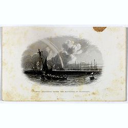
Taking soundings under the batteries of Cronstadt.
Steel engraving showing a small boat taking soundings under the batteries of Kronstadt from a drawing by J. W. Carmichael, engraved by E. Brandard. From "The History...
- $20 / ≈ €17
Date: London, Virtue, ca. 1857
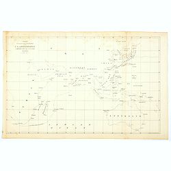
Chart showing the track of the Flagships of the US-Japan Expedition to the eastward of the Cape of Good Hope 1853 & 1854.
A simple sea chart showing the track of the US Steam Frigate Mississippi as she tracked her way from east of Cape Town across the Indian Ocean and the Bay of Bengal, up t...
- $50 / ≈ €42
Date: New York, 1857
The Caspian Sea, Khivah, and the surrounding country compiled from the best sources by John Arrowsmith
This is a very detailed map of the Caspian Sea regions to the north and east. It includes the Caspian Sea, Aral Sea, and the khanate of Khiva, including parts of today's ...
- $450 / ≈ €381
Date: London, 1846-1858
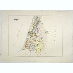
Giudea (Tav I)
A large-format map of the Holy Land with its dioceses. The map is finely engraved and beautifully colored and was prepared by Girolamo Petri, a lawyer who served as a sen...
- $600 / ≈ €508
Date: Rome, 1858
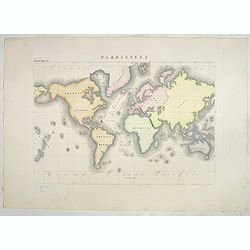
Planisfero (Tav III)
A large-format world map with a key to the steamship routes, telegraph lines and land routes in Europe. Finely engraved and beautifully colored and was prepared by Girola...
Date: Rome, 1858
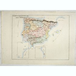
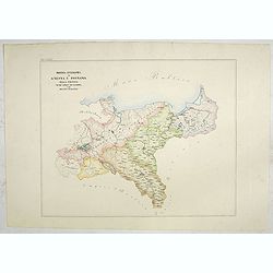
Circoscrizione delle province ecclesiastiche e Diocesinei regni di Spagna e Portogallo (Tav XLVI)
A large-format map of Spain and Portugal with its dioceses. The map is finely engraved and beautifully colored and was prepared by Girolamo Petri, a lawyer who served as ...
- $450 / ≈ €381
Date: Rome, 1858

Circoscrizione delle Provincie ecclesiastiche e Diocesi nei regni del Belgio, ed Olanda (Tav LXI)
This large-format map showing Belgium and Holland with its different dioceses. The map is finely engraved and beautifully colored and was prepared by Girolamo Petri, a la...
Date: Rome, 1858

Provincia ecclesiastica di Malines nel Belgio (Tav LXII)
This large-format map of Belgium with its different dioceses. The map is finely engraved and beautifully colored and was prepared by Girolamo Petri, a lawyer who served a...
Date: Rome, 1858
![[The Netherlands] Provincia ecclesiastica di Utrecht Nell' Olanda (Tav LXIII)](/uploads/cache/44104-250x250.jpg)
[The Netherlands] Provincia ecclesiastica di Utrecht Nell' Olanda (Tav LXIII)
This large-format map of The Netherlands with its different dioceses. The map is finely engraved and beautifully colored and was prepared by Girolamo Petri, a lawyer who ...
- $250 / ≈ €212
Date: Rome, 1858
![[Czech Republic] Provincia ecclesiastica di Praga nell' Impero Austriaco (Tav LXVIII)](/uploads/cache/44108-250x250.jpg)
[Czech Republic] Provincia ecclesiastica di Praga nell' Impero Austriaco (Tav LXVIII)
A large-format map of Czech Republic centered on Prague with its different dioceses. The map is finely engraved and beautifully colored and was prepared by Girolamo Pet...
- $300 / ≈ €254
Date: Rome, 1858
Provincia ecclesiastica di Gnesna e Posnania nella Prussia Vicar.ti apost.cl di Sassonia e Dei Ducati Analtini (Tav LXXXII)
A large-format map of western Poland with its different dioceses. The map is finely engraved and beautifully colored and was prepared by Girolamo Petri, a lawyer who serv...
- $500 / ≈ €424
Date: Rome, 1858
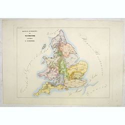
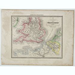
Provincia ecclesiastica di Westminster Londra in Inghilterra (Tav LXXXIV)
A large-format map of the British Isles with its different dioceses. The map is finely engraved and beautifully colored and was prepared by Girolamo Petri, a lawyer who s...
- $300 / ≈ €254
Date: Rome, 1858
![[Scotland] Vicariati Apostolici nella Scozia (Tav LXXXV)](/uploads/cache/44125-250x250.jpg)
[Scotland] Vicariati Apostolici nella Scozia (Tav LXXXV)
A large-format map of Scotland with its different dioceses. The map is finely engraved and beautifully colored and was prepared by Girolamo Petri, a lawyer who served as ...
- $350 / ≈ €296
Date: Rome, 1858
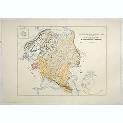
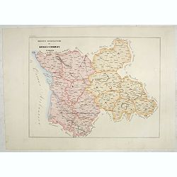
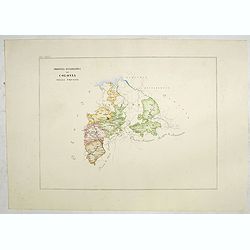
Circoscrizione delle Province ecclesiastiche e Diocesi nelle Impero di Russia in Europa vicariato aplico di Svezia Norvegia e prefettura del Polo Artico (Tav XC)
A large-format map of Sweden, Norway, Russia with its different dioceses. Inset map of Iceland and a North Pole projection. The map is finely engraved and beautifully col...
- $550 / ≈ €466
Date: Rome, 1858
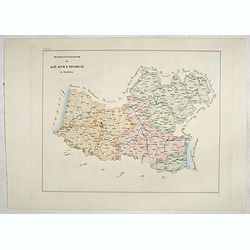
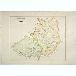
Provincia ecclesiastica di Mohilow nell' Impero Russo (Tav XCII)
A large-format map of Russia, Georgie, Black Sea region with its different dioceses. The map is finely engraved and beautifully colored and was prepared by Girolamo Petri...
- $400 / ≈ €339
Date: Rome, 1858
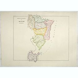
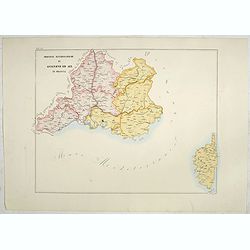
Provincia ecclesiastica di Naxos e delegazione aplica di Grecia. (Tav XCVII)
A large-format map of Naxos with it's dioceses. This Greek island in the South Aegean, is the largest of the Cyclades island group. The map is finely engraved and beautif...
- $250 / ≈ €212
Date: Rome, 1858
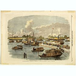
Sick and wounded embarking at Hong-Kong on Board the Steamer.
Large view of the harbour with numerous ships and people. From the Illustrated London News, October 23, 1858.
Date: London, October 1858
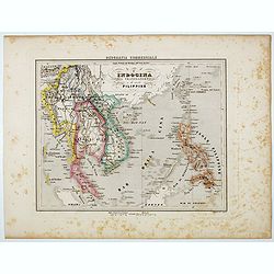
L'Indocina India Transgangetica e le Isole Filippine.
Uncommon map of part of Indo China and the Philippines prepared by Francesco Costantino Marmocchi. Above the map "Geografia Commerciale". From "Il Globo At...
Date: Genova, Paolo Rivara fu Giacomo, 1858
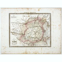
La Cina propriamente detta e sue isole.
Uncommon map of China prepared by Francesco Costantino Marmocchi. Above the map "Geografia Commerciale". From "Il Globo Atlante di carte Geografiche compil...
Date: Genova, Paolo Rivara fu Giacomo, 1858
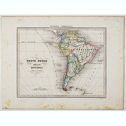
Nuovo Mondo parte Meridionale.
Uncommon map of South America prepared by Francesco Costantino Marmocchi. Above the map "Geografia Commerciale". From "Il Globo Atlante di carte Geografich...
Date: Genova, Paolo Rivara fu Giacomo, 1858
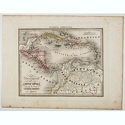
Le Indie Ocidentali ( Antille maggiori e minori, ecc) L'America Centrale . . .
Uncommon map of Central America and the Antilles prepared by Francesco Costantino Marmocchi. Above the map "Geografia Commerciale". From "Il Globo Atlante ...
Date: Genova, Paolo Rivara fu Giacomo, 1858
![[Title page ] Il Globo Atalante di carte geografiche compilate da F.C. Marmocchi per servire di corredo al suo Corso di geografia commerciale.]](/uploads/cache/45291-250x250.jpg)
[Title page ] Il Globo Atalante di carte geografiche compilate da F.C. Marmocchi per servire di corredo al suo Corso di geografia commerciale.]
Title page prepared for Francesco Costantino Marmocchi's Atlas "Il Globo Atlante di carte Geografiche compilate da F.C. Marmocchi per servire di corredo al suo corso...
Date: Genova, Paolo Rivara fu Giacomo, 1858
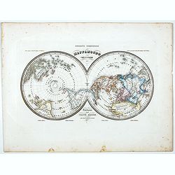
Mappamondo Carta d'Insieme.
Uncommon double hemisphere pole projection prepared by Francesco Costantino Marmocchi. Above the map "Geografia Commerciale". With a color code underneath the m...
Date: Genova, Paolo Rivara fu Giacomo, 1858
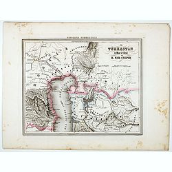
Il Turkestan il Mar d'Aral ed il Mar Caspio.
Uncommon map of Turkestan with the Northern part of the Caspian Sea, with part of present-day Uzbekistan in the lower right corner. in the prepared by Francesco Costant...
Date: Genova, Paolo Rivara fu Giacomo, 1858
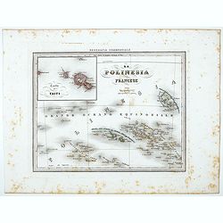
La Polinesia Francese.
Uncommon map of French Polynesia prepared by Francesco Costantino Marmocchi. Above the map "Geografia Commerciale". From "Il Globo Atlante di carte Geograf...
Date: Genova, Paolo Rivara fu Giacomo, 1858
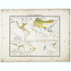
Distribuzione geografica delle Pianta coltivate . . .
Uncommon world map in Mercator projection representing food resources on 3 inset maps, prepared by Francesco Costantino Marmocchi. Above the map "Geografia Commercia...
Date: Genova, Paolo Rivara fu Giacomo, 1858
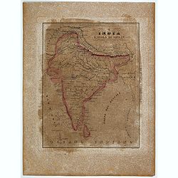
L'India e L'Isola di Seilan.
Uncommon map of India prepared by Francesco Costantino Marmocchi. Above the map "Geografia Commerciale". From "Il Globo Atlante di carte Geografiche compil...
Date: Genova, Paolo Rivara fu Giacomo, 1858
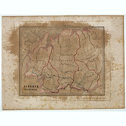
Siberia Occidentale.
Uncommon map of Siberia prepared by Francesco Costantino Marmocchi. Above the map "Geografia Commerciale". From "Il Globo Atlante di carte Geografiche comp...
- $50 / ≈ €42
Date: Genova, Paolo Rivara fu Giacomo, 1858
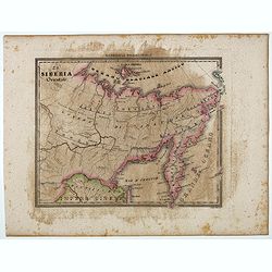
La Siberia Orientale.
Uncommon map of Oriental Siberia prepared by Francesco Costantino Marmocchi. Above the map "Geografia Commerciale". From "Il Globo Atlante di carte Geograf...
- $50 / ≈ €42
Date: Genova, Paolo Rivara fu Giacomo, 1858
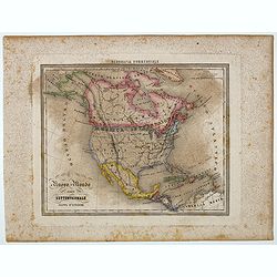
Nuovo Mondo parte Settentrionale.
Uncommon map of North America prepared by Francesco Costantino Marmocchi. Above the map "Geografia Commerciale". From "Il Globo Atlante di carte Geografich...
- $50 / ≈ €42
Date: Genova, Paolo Rivara fu Giacomo, 1858
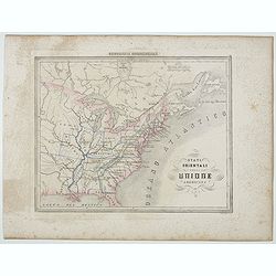
Stati Orientali della Unione Americana.
Uncommon map of Northeastern America prepared by Francesco Costantino Marmocchi. Above the map "Geografia Commerciale". From "Il Globo Atlante di carte Geo...
- $50 / ≈ €42
Date: Genova, Paolo Rivara fu Giacomo, 1858
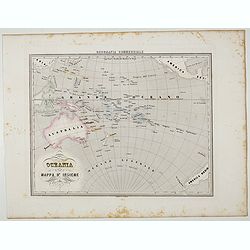
Oceania.
Uncommon map of Pacific ocean prepared by Francesco Costantino Marmocchi. Above the map "Geografia Commerciale". From "Il Globo Atlante di carte Geografich...
- $50 / ≈ €42
Date: Genova, Paolo Rivara fu Giacomo, 1858
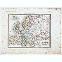
Europa.
Uncommon map of Europe prepared by Francesco Costantino Marmocchi. Above the map "Geografia Commerciale". From "Il Globo Atlante di carte Geografiche compi...
- $50 / ≈ €42
Date: Genova, Paolo Rivara fu Giacomo, 1858
Bacino del Mediterraneo (Parte occidentale) . . .
Uncommon map of Mediterranean Basin prepared by Francesco Costantino Marmocchi. Above the map "Geografia Commerciale". From "Il Globo Atlante di carte Geog...
- $50 / ≈ €42
Date: Genova, Paolo Rivara fu Giacomo, 1858
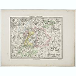
Le Vie Ferrate e le Strade Postali della Germania centrale e meridionale . . .
Uncommon map of Germany and part of France and Switzerland prepared by Francesco Costantino Marmocchi. Above the map "Geografia Commerciale". From "Il Glob...
- $25 / ≈ €21
Date: Genova, Paolo Rivara fu Giacomo, 1858
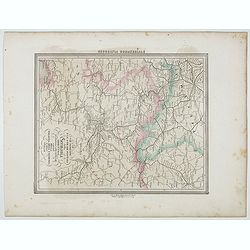
Le Vie Ferrate e le Strade Postali della Germania orientale . . .
Uncommon map of Germany and part of Poland, Hungary and Italy prepared by Francesco Costantino Marmocchi. Above the map "Geografia Commerciale". From "Il G...
- $25 / ≈ €21
Date: Genova, Paolo Rivara fu Giacomo, 1858
Le Vie Ferrate e Postali dell' Inchilterra . . .
Uncommon map of England and part of France prepared by Francesco Costantino Marmocchi. Above the map "Geografia Commerciale". From "Il Globo Atlante di car...
- $25 / ≈ €21
Date: Genova, Paolo Rivara fu Giacomo, 1858
![[Double-hemispher World Map] Descrizione del Globo in due emisferi . . .](/uploads/cache/44079-250x250.jpg)
[Double-hemispher World Map] Descrizione del Globo in due emisferi . . .
This large-format map is finely engraved and beautifully colored and was prepared by Girolamo Petri, a lawyer who served as a senior official within the Vatican’s State...
- $1750 / ≈ €1482
Date: Rome, 1858
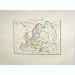
Carta generale di Europa (Tav IV)
This large-format Europe map is finely engraved and beautifully colored and was prepared by Girolamo Petri, a lawyer who served as a senior official within the Vatican’...
- $750 / ≈ €635
Date: Rome, 1858
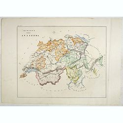
Diocesi della Svizzera (Tav IV)
This large-format Switzerland map is finely engraved and beautifully colored and was prepared by Girolamo Petri, a lawyer who served as a senior official within the Vatic...
- $750 / ≈ €635
Date: Rome, 1858
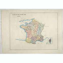
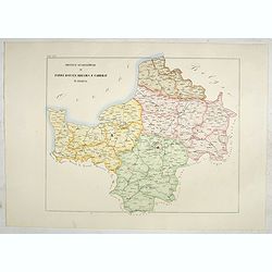
Circscrizione delle province ecclesiastiche e diocesi in Francia (Tav LIII)
This large-format France and Corsica map is finely engraved and beautifully colored and was prepared by Girolamo Petri, a lawyer who served as a senior official within th...
- $300 / ≈ €254
Date: Rome, 1858
Province ecclesiastiche di Parigi, Rouen, Rheims, E Cambray in Francia (Tav LIV)
This large-format Paris, Rouen, Reims and Cambray map is finely engraved and beautifully colored and was prepared by Girolamo Petri, a lawyer who served as a senior offic...
- $300 / ≈ €254
Date: Rome, 1858
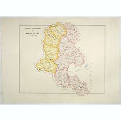
Province ecclesiastiche di Lione e Sens in Francia (Tav LV)
This large-format Lion and Sens map is finely engraved and beautifully colored and was prepared by Girolamo Petri, a lawyer who served as a senior official within the Vat...
- $300 / ≈ €254
Date: Rome, 1858
Province ecclesiastica di Besançon in Francia (Tav LVI)
This large-format Besançon map is finely engraved and beautifully colored and was prepared by Girolamo Petri, a lawyer who served as a senior official within the Vatican...
- $300 / ≈ €254
Date: Rome, 1858
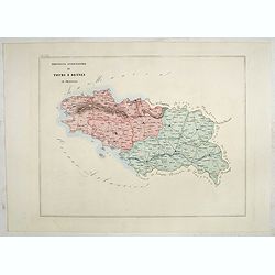
Province ecclesiastica di Tours e Rennes in Francia (Tav LVII)
This large-format Tours and Rennes map is finely engraved and beautifully colored and was prepared by Girolamo Petri, a lawyer who served as a senior official within the ...
- $300 / ≈ €254
Date: Rome, 1858
Province ecclesiastiche di Bourges e Bordeaux in Francia (Tav LVIII)
This large-format Bourges and Bordeaux map is finely engraved and beautifully colored and was prepared by Girolamo Petri, a lawyer who served as a senior official within ...
- $300 / ≈ €254
Date: Rome, 1858
Province ecclesiastiche di Albi, Auche e Toulouse in Francia (Tav LIX)
This large-format Albi, Auch and Toulouse map is finely engraved and beautifully colored and was prepared by Girolamo Petri, a lawyer who served as a senior official with...
- $300 / ≈ €254
Date: Rome, 1858
Province ecclesiastiche di Avignone ed Aix in Francia (Tav LX)
This large-format Avignon and Aix map is finely engraved and beautifully colored and was prepared by Girolamo Petri, a lawyer who served as a senior official within the V...
- $300 / ≈ €254
Date: Rome, 1858
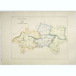
Provincia ecclesiastica di Vienna nell' Impero Austriaco (Tav LXV)
A large-format map of Vienna / Austria with it's different dioceses. The map is finely engraved and beautifully colored and was prepared by Girolamo Petri, a lawyer who s...
- $350 / ≈ €296
Date: Rome, 1858
Provincia ecclesiastica di Colonia nella Prussia (Tav LXXXI)
This large-format south Germany Cologne map is finely engraved and beautifully colored and was prepared by Girolamo Petri, a lawyer who served as a senior official within...
- $250 / ≈ €212
Date: Rome, 1858
![[British Isles] Circoscrizione delle Province ecclesiastiche e Diocesi d'Inghilterra Irlanda e dei Vicariati in scozia (Tav LXXXIII)](/uploads/cache/44123-250x250.jpg)
[British Isles] Circoscrizione delle Province ecclesiastiche e Diocesi d'Inghilterra Irlanda e dei Vicariati in scozia (Tav LXXXIII)
This large-format British Isles map is finely engraved and beautifully colored and was prepared by Girolamo Petri, a lawyer who served as a senior official within the Vat...
- $250 / ≈ €212
Date: Rome, 1858
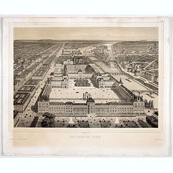
Souvenir de Paris.
Decorative bird's-eye view of the current Louvre Museum, with river Seine and the Notre Dame cathedral on the right. of Paris. After a design by P. St. Martin.
Date: Paris, ca. 1858
Provincia ecclesiastica di Olmütz nell' Impero Austriaco (Tav LXIX)
This large-format Austria Olomouc province map is finely engraved and beautifully colored and was prepared by Girolamo Petri, a lawyer who served as a senior official w...
- $200 / ≈ €169
Date: Rome, 1858
Volume III of the monumental atlas, ‘L’Orbe Cattolico ossia Atlante Geografico Storico Ecclesiastico’.
PETRI Girolamo's extremely rare Atlas volume III of the monumental atlas, ‘L’Orbe Cattolico ossia Atlante Geografico Storico Ecclesiastico’, respectively depictin...
Date: Rome, 1858
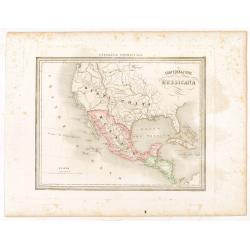
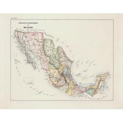
Confederazione Messicana.
Uncommon map of Mexico and the Transmississippi West, includes the name Texas, prepared by Francesco Costantino Marmocchi. Above the map "Geografia Commerciale"...
Date: Genova, Paolo Rivara fu Giacomo, 1858

Exposé des travaux astronomiques en Russie (Atlas) with Supplément à l’exposé des travaux astronomiques et géodésiques exécutés en Russie contenant les noms, en langue russe de toutes les positions données au chapitre V (supplément I only).
Very rare atlas published to accompany Exposé des travaux astronomiques et géodésiques exécutés en Russie dans un but géographique jusqu’à l’année 1855. St.-P...
Date: St. Petersburg, Imperial Academy of Sciences: Eggers & Co., and Leipzig, Leopold Voss, 1858
La Rue des Tombeaux à Pompeia.
Uncommon and decorative lithography published by Carl Johan Billmark and printed by Lemercier in Paris, 55 rue de Seine, the leading firm in Europe at that time. From: ...
- $80 / ≈ €68
Date: Paris, c.1859
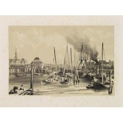
Hambourg.
Uncommon and decorative lithography of the harbor of Hamburg, published by Carl Johan Billmark and printed by Lemercier in Paris, 55 rue de Seine, the leading firm in Eur...
Date: Paris, c.1859
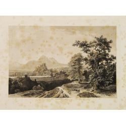
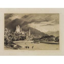
Salzbourg.
Uncommon and decorative lithography published by Carl Johan Billmark and printed by Lemercier in Paris, 55 rue de Seine, the leading firm in Europe at that time. From: It...
Date: Paris, c.1859
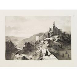
Sigmundskron (Tyrol, près de Bolzan).
Uncommon and decorative lithography published by Carl Johan Billmark and printed by Lemercier in Paris, 55 rue de Seine, the leading firm in Europe at that time. From: It...
- $60 / ≈ €51
Date: Paris, c.1859
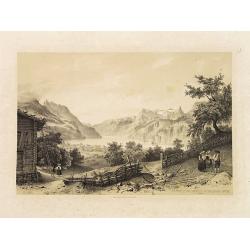
Thoun.
Uncommon and decorative lithography published by Carl Johan Billmark and printed by Lemercier in Paris, 55 rue de Seine, the leading firm in Europe at that time. From: It...
- $80 / ≈ €68
Date: Paris, c.1859
Brunnen et une Partie du Lac des Quatre Cantons.
Uncommon and decorative lithography published by Carl Johan Billmark and printed by Lemercier in Paris, 55 rue de Seine, the leading firm in Europe at that time. From: It...
- $80 / ≈ €68
Date: Paris, c.1859
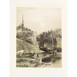
Ecluses à Trollhattan (Suède)..
Uncommon and decorative lithography published by Carl Johan Billmark and printed by Lemercier in Paris, 55 rue de Seine, the leading firm in Europe at that time. From: It...
- $80 / ≈ €68
Date: Paris, c.1859
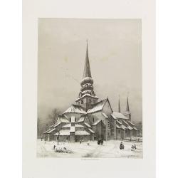
Eglise de Warnhem (Suède).
Uncommon and decorative lithography was published by Carl Johan Billmark and printed by Lemercier in Paris, 55 rue de Seine, the leading firm in Europe. From: Itinéraire...
- $80 / ≈ €68
Date: Paris, c.1859