Browse Listings
Der Kreml in Moscau.
View of Moscow with in the background the Kremlin. Original steel engraving, published by Bibliographisches Institut Hildburghausen. Engraved by H.Hauser.
- $30 / ≈ €25
Date: Hildburghausen, 1850
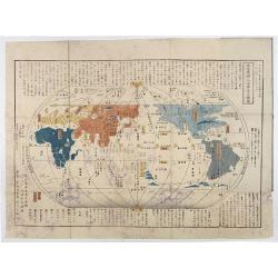
Chikyu Bankoku sankai yochi zenzu setsu. / Sekisui Cho Harutaka. (Map and description of geography of all the countries of the globe).
Reduced version of the famous map "Kaisei chikyu bankoku zenzu" by Sekisui Nagakubo (1717-1801) published ca. 1785, still based on the one by Matteo Ricci. Incl...
- $3500 / ≈ €2965
Date: Tokyo, 1850
![[Untitled map of the European countries in a playing grid].](/uploads/cache/38468-250x250.jpg)
[Untitled map of the European countries in a playing grid].
Small, accurate lithographed maps of Europe, embedded in a square playing grid formed by 100 cells.The 11 cells contain the profile or a reference to an Emperors, some ce...
- $100 / ≈ €85
Date: France, ca. 1850
![[Untitled map of the European countries in a playing grid].](/uploads/cache/38469-250x250.jpg)
[Untitled map of the European countries in a playing grid].
Small, accurate lithographed map of Europe, embedded in a square playing grid formed by 100 cells.The 11 cells contain the profile of or a reference to Emperors, some cel...
- $100 / ≈ €85
Date: France, ca. 1850
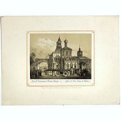
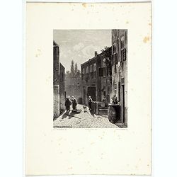
Eglise de Notre Dame de Vladimir.
The church of Holy Mary in Vladimi with in the foreground a ceremony with bishops, monks and faithful viewers. Below a caption in French and in Cyril.
- $45 / ≈ €38
Date: Russia or France, ca. 1850
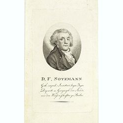
D.F. Sotzmann.
Portrait of Daniel Friedrich Sotzmann (1754 - 1840), engraved by F. Westermayr. Sotzman was a German cartographer and surveyor. He is considered the main initiator of the...
- $200 / ≈ €169
Date: Berlin ? , ca. 1850
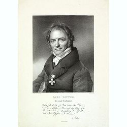
Carl Ritter
Lithographed portrait of Carl Ritter (August 7, 1779 – September 28, 1859) after a design by Prof. Krüger and lithographed by F. Jentzen. Published by G.Reimer in Berl...
- $300 / ≈ €254
Date: Berlin, ca. 1850
![[Untitled map of the European countries in a playing grid].](/uploads/cache/38460-250x250.jpg)
[Untitled map of the European countries in a playing grid].
Small, accurate lithographed maps of Europe and Asia, embedded in a square playing grid formed by 100 cells.The 11 cells contain the profile of or a reference to a empero...
- $125 / ≈ €106
Date: France, ca. 1850
![[Untitled map of the European countries in a playing grid].](/uploads/cache/38466-250x250.jpg)
[Untitled map of the European countries in a playing grid].
Small, accurate lithographed maps of Europe and Asia, embedded in a square playing grid formed by 100 cells.The 11 cells contain the profile of or a reference to a empero...
- $125 / ≈ €106
Date: France, ca. 1850
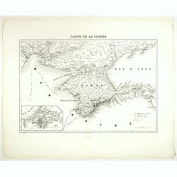
Carte de la Crimée.
Attractive map of Crimea with inset plan of Sevastopol, prepared by Alexandre Aimé Vuillemin (1812-1886). A road system and the ferry lines are drawn in.Engraved by Jaco...
- $150 / ≈ €127
Date: Paris, ca. 1850
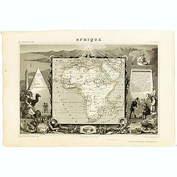
Afrique.
A decorative 19th century map of the continent colored to show the colonial possessions and major tribal kingdoms. The interior is mostly void of detail. The map is surro...
Date: Paris, 1850
![[Untitled map of the European countries in a playing grid].](/uploads/cache/38461-250x250.jpg)
[Untitled map of the European countries in a playing grid].
Small, accurate lithographed maps of Europe and Asia, embedded in a square playing grid formed by 100 cells.The 11 cells contain the profile of or a reference to a empero...
- $100 / ≈ €85
Date: France, ca. 1850
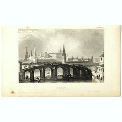
Moscau von der Kreml-Seite.
Steel engraving with a panoramic view of the Kremlin in Moscow, published in "Meyers Universum oder Abbildung und Beschreibung des Sehenswerthesten und Merkwürdigst...
- $20 / ≈ €17
Date: 1850
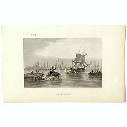
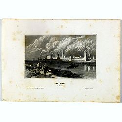
Archangel.
Steel engraving of Archangel, published by the German publishing company Bibliographisches Institut which was founded 1826 in Gotha by Joseph Meyer, moved 1828 to Hildbur...
- $25 / ≈ €21
Date: Hildburghausen, 1850
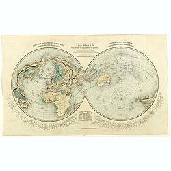
The Earth projected on the horizon of London.
Double hemisphere orientated on the north and south poles.
- $150 / ≈ €127
Date: London, 1850
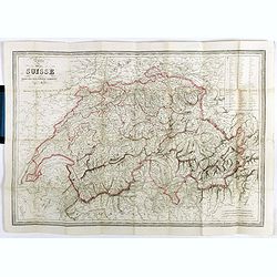
Carte de la Suisse . . .
Detailed canvas map of Switzerland.
Date: Paris, 1850
![[7 Indian Patna water colors of crafts.]](/uploads/cache/43663-250x250.jpg)
[7 Indian Patna water colors of crafts.]
Seven Company school, also called Patna painting, style of miniature painting that developed in India in the second half of the 18th century in response to the tastes of ...
- $750 / ≈ €635
Date: India, ca.1850
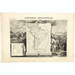
Amerique Meridionale.
A very decorative 19th century map of the continent colored to show political divisions. The map is surrounded by fully colored, steel engraved scenes including horses, I...
- $150 / ≈ €127
Date: Paris, 1850
![[Untitled map of the European countries in a playing grid].](/uploads/cache/38462-250x250.jpg)
[Untitled map of the European countries in a playing grid].
Small, accurate lithographed maps of Europe and Asia, embedded in a square playing grid formed by 100 cells.The 11 cells contain the profile of or a reference to an emper...
- $100 / ≈ €85
Date: France, ca. 1850
![[Untitled map of the European countries in a playing grid].](/uploads/cache/38463-250x250.jpg)
[Untitled map of the European countries in a playing grid].
Small, accurate lithographed maps of Europe and Asia, embedded in a square playing grid formed by 100 cells.The 11 cells contain the profile of or a reference to an emper...
- $125 / ≈ €106
Date: France, ca. 1850
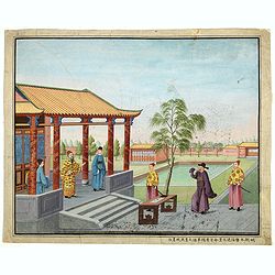
Chinese Export watercolor.
Chinese watercolor with in lower margin Chinese text : Chinese watercolor - " A farmer's thief, a book, a big manuscipt, a filial piety, a martial art. " [Googl...
- $1000 / ≈ €847
Date: China, ca. 1850
![[Untitled map of the European countries in a playing grid].](/uploads/cache/38464-250x250.jpg)
[Untitled map of the European countries in a playing grid].
Small, accurate lithographed maps of Europe and Asia, embedded in a square playing grid formed by 100 cells.The 11 cells contain the profile of or a reference to a empero...
- $125 / ≈ €106
Date: France, ca. 1850
![[Untitled map of the European countries in a playing grid].](/uploads/cache/38470-250x250.jpg)
[Untitled map of the European countries in a playing grid].
Small, accurate lithographed maps of Europe and Asia, embedded in a square playing grid formed by 100 cells.The 11 cells contain the profile of or a reference to a empero...
- $110 / ≈ €93
Date: France, ca. 1850
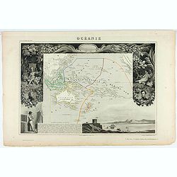
Océanie.
A very decorative 19th century map of the Pacific Ocean, with hand colored lines indicating the extent of Polynesia, Micronesia, Melanesia, and Malaysia (or Southeast Asi...
Date: Paris, 1850
![Aux grands maux les grands remedes. [To great ills great remedies]](/uploads/cache/46558-250x250.jpg)
Aux grands maux les grands remedes. [To great ills great remedies]
A humorous French lithograph showing a village scene where a small infant is held face down on his/her mother's lap, with clothing pulled up to reveal its bottom. An enor...
Date: Paris, ca 1850
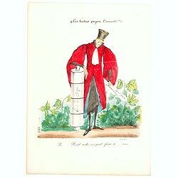
(Les battus payem l'ammende!!)
A French proverb - The beaten pay the fine. It looks like a French lawyer holds a large clyster with one hand, and a rolled document in the other. The French caption belo...
Date: Paris, ca. 1850
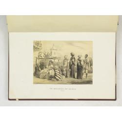
(Album Pallière. Escenas Americanas. Reduccion de Cuadros, aquarelles y bosquejos.)
51 (of 52 )beautifully lithographed plates on tinted ground, lithographed by J. Pelvilain after designs by Juan Léon Palliere. One plate missing : santiagueña tejiendo ...
- $10000 / ≈ €8470
Date: Buenos Aires, en venta en la casa de los S.res Fusoni H.nos, ca. 1850
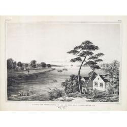
Dutch street scene.
Attractive lithography showing a Dutch street scene, lithographed by F.H. Weissenbruch after a painting of Jan Weissenbruch.
- $50 / ≈ €42
Date: The Hague, 1850
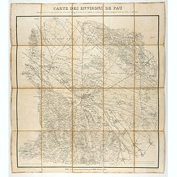
Carte des environs de Pau. . .
Folding map of Pau and its surroundings, being a reduced version of the map by Comte Dulong de Rosnay and engraved by Nicolas Delamare and published by Lafon.More about f...
- $75 / ≈ €64
Date: Pau, Lafon, 1840-1850
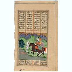
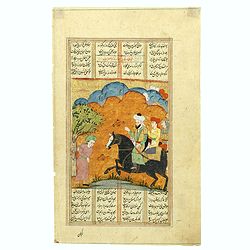
Persian miniature paintings, Mogul Dynasty.
Indo/Persian, Mogul Dynasty miniature painting in delicate Opaque watercolors on paper, with Islamic scripts on recto and verso. Miniature about 135 x 150mm. Painted in g...
Date: Northern Indian Mogul dynasty, ca 1800-1850
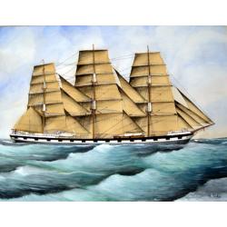
Original Maritime painting of the 'Cape Horn' , a so-called captain's ship drawing by R. Takes
A fine example of a so-called 'captain's portrait' of a clipper-ship under full sail.The name of the ship at the bow reads "Cape Horn" Signed in the lower right...
Date: c. 1850
![[Original drawing: Fisher's ships on the beach of Scheveningen.]](/uploads/cache/984-250x250.jpg)
[Original drawing: Fisher's ships on the beach of Scheveningen.]
Unique pencil drawing: Typical Dutch beach life with flat-bottomed ships on the beach of Scheveningen. Signed in the lower right corner and on the back site with P.A....
Date: c. 1850
![[Game of the goose] Het nieuw vermakelijk ganzenspel. Le nouveau jeu d'Oie.](/uploads/cache/48329-250x250.jpg)
[Game of the goose] Het nieuw vermakelijk ganzenspel. Le nouveau jeu d'Oie.
Game of 63 boxes, spiral, counter clockwise. Goose board game with spiral with 63 numbered squares. In different boxes a representation of a goose. In a box on the center...
- $150 / ≈ €127
Date: Turnhout, ca.1850
Persian miniature paintings, Mogul Dynasty.
Indo/Persian, Mogul Dynasty miniature painting in delicate Opaque watercolors on paper, with Islamic scripts on recto and verso. Miniature about 1350 x 150mm. Painted in ...
- $100 / ≈ €85
Date: Northern Indian Mogul dynasty, ca 1800-1850
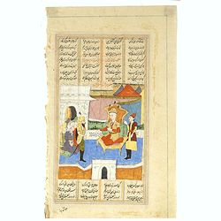
Persian miniature paintings, Mogul Dynasty.
Indo/Persian, Mogul Dynasty miniature painting in delicate Opaque watercolors on paper, with Islamic scripts on recto and verso. Miniature about 70 x 150mm. Painted in gi...
- $100 / ≈ €85
Date: Northern Indian Mogul dynasty, ca 1800-1850
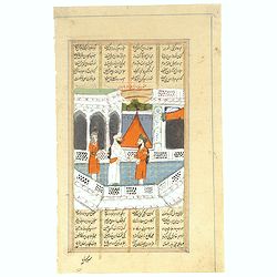
Persian miniature paintings, Mogul Dynasty.
Indo/Persian, Mogul Dynasty miniature painting in delicate Opaque watercolors on paper, with Islamic scripts on recto and verso. Miniature about 70 x 150mm. Painted in gi...
Date: Northern Indian Mogul dynasty, ca 1800-1850
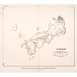
A rare and impressive pictorial Qing Empire map of the western part of Taiwan.
The top of the map faces east, the bottom faces west, and the left and right are north-south. It is about 120 cm high and 225 cm long. The map shows only to the west of t...
Date: ca. 1850
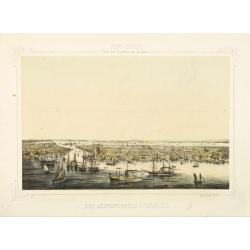
New York von der Seeseite aus gesehen.
Very decorate view of New-York. J.Hesse was known as a portrait painter and publisher of lithographs. A long panorama of the shoreline from the sea, with sailing vessels ...
- $700 / ≈ €593
Date: Berlin, c. 1850
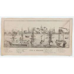
View of Singapore
Very rare view of Singapore from the Singapore River Basin. With a numbered key (1-19) underneath the illustration. In the center Government Hill with Governer's House (1...
Date: ca. 1850
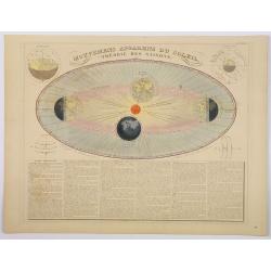
Mouvemens Apparens du Soleil, Theorie des Saisons.
A nice and attractive example of Andriveau-Goujon's decorative chart depicting the theory of the seasons as the earth orbits the Sun in an elliptical fashion, with 4 smal...
Date: Paris 1850
![Posesiones de America : Isla de Cuba. [together with] Isla de Cuba. . .](/uploads/cache/23458-250x250.jpg)
Posesiones de America : Isla de Cuba. [together with] Isla de Cuba. . .
Wall size sea chart and map of land areas showing all of Cuba, part of Florida Keys plus San Adios and Salvador Grande in the Bahamas.Minute topographical, political, and...
Date: Madrid, 1853 / 1851

Plan de Constantinople, non compris ses faubourgs. Grave d'apres les documents du ministere de la Guerre par E. Olivier.
A very rare lithographic large-scale town-plan of Istanbul, Scale 98 yards to one inch., printed in Pera, Istanbul by E. Olivier. The ornate design on the top of the...
Date: Péra, Istanbul, 1851
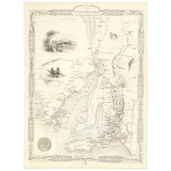
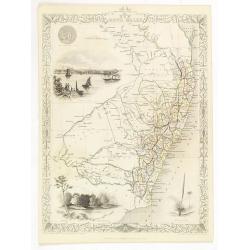
Part of South Australia.
Decorative steel engraved map of part of South Australia, surrounded by illustrations of Adelaide, natives on a catamaran, an Australian dog and a nymphicus bird illustra...
Date: London, ca. 1851
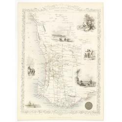
New South Wales.
Decorative steel engraved map of New South Wales, surrounded by illustrations of Sydney Cove, native trees and the seal of New South Wales. Interlocking border design. Ta...
- $300 / ≈ €254
Date: London, ca. 1851
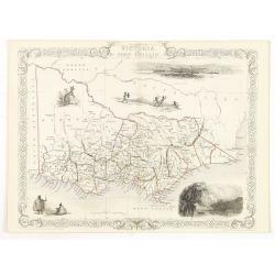
Victoria or Port Phillip.
Decorative steel engraved map of Victoria or Port Phillip, surrounded by illustrations of Melbourne, indigenous people and the Glenelg River. Interlocking border design. ...
Date: London, ca. 1851
Western Australia. Swan River.
Decorative steel engraved map of part of Western Australia and Swan River, surrounded by illustrations of Perth, Aborigines and sheep shearing. With the seal of Western A...
Date: London, ca. 1851
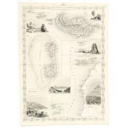
Islands in the Atlantic.
Decorative steel engraved map of Islands showing the Azores, Madeira, Bermuda, the Canaries and the Cape Verdes. Interlocking border design. Taken from "The illustra...
Date: London, ca. 1851
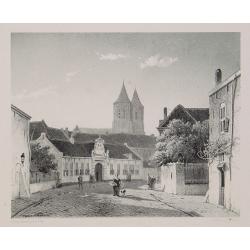
Arnhem
Attractive lithography showing a street scene in Arnhem. Lithographed by Jan Weissenbruch, published by C.W. Mieling, included in Kunst Kroniek.
- $65 / ≈ €55
Date: The Hague, 1851
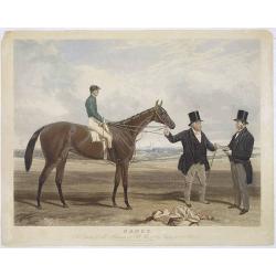
Nancy. . .
Very fine color print of racing horse ,Nancy,: the property of Mr Martinson of Hull. Engraved by Charles Hunt after a painting by Harry Hall.
Date: London, 1851
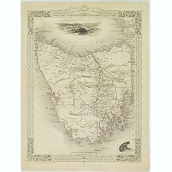
Van Diemen's Island or Tasmania.
Decorative steel engraved map of Tasmania. Taken from "The illustrated atlas and modern history of the world by John Tallis", published between 1849 and 1853. T...
- $225 / ≈ €191
Date: London, 1851
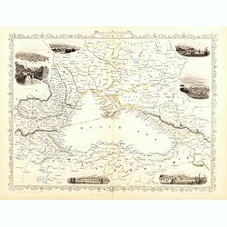
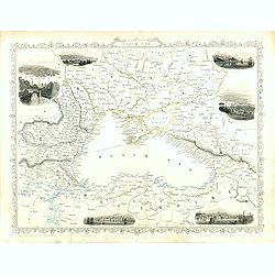
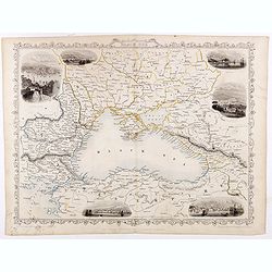
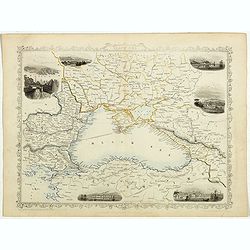
Black Sea.
Decorative steel engraved map of the Black Sea with inset views of Sebastopol and Odessa. There are also vignettes of Constantinople, Sinope and Varna. Taken from "T...
- $110 / ≈ €93
Date: London, London Printing and publishing Company of London, ca. 1851
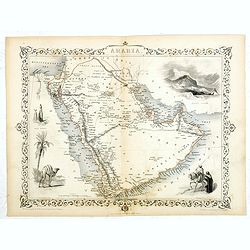
Arabia.
A highly decorative and detailed map of Arabia, drawn and engraved by J.Rapkin and the Illustrations by H. Warren after J. Rogers.Taken from "The illustrated atlas a...
- $275 / ≈ €233
Date: London / New York: John Tallis & co, c.1851
East Canada and New Brunswick.
This is John Tallis’ map of East Canada or what is now Quebec and New Brunswick. Includes Montreal, Quebec City, and the St. Lawrence River valley. Features five vignet...
- $75 / ≈ €64
Date: London, 1851
Black Sea.
Decorative steel engraved map of the Black Sea with inset views of Sebastopol and Odessa. There are also vignettes of Constantinople, Sinope and Varna. Taken from "T...
Date: London, London Printing and publishing Company of London, ca. 1851
Black Sea.
Decorative steel engraved map of the Black Sea with inset views of Sebastopol and Odessa. There are also vignettes of Constantinople, Sinope and Varna. Taken from "T...
- $90 / ≈ €76
Date: London, London Printing and publishing Company of London, ca. 1851
Black Sea.
Decorative steel engraved map of the Black Sea with inset views of Sebastopol and Odessa. There are also vignettes of Constantinople, Sinope and Varna. Taken from "T...
- $90 / ≈ €76
Date: London, London Printing and publishing Company of London, ca. 1851
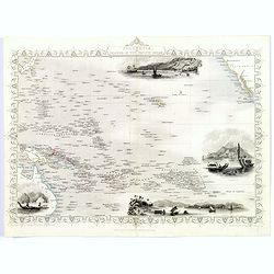
Polynesia or Islands in the Pacific Ocean.
Decorative and attractive map of the Islands in the Pacific Ocean. The map extent shows parts of California, Papua New Guinea, eastern Australia, and southern Japan.The m...
- $175 / ≈ €148
Date: London ,1851
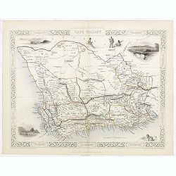
Cape Colony.
A decorative steel engraved map from the famous Victorian publisher John Tallis and Company, published ca.1851. Drawn and engraved by J Rapkin, while the four corner vign...
Date: London, Edinburgh, Dublin, 1851
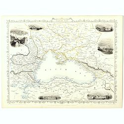
Black Sea.
Decorative steel engraved map of the Black Sea with inset views of Sebastopol and Odessa. There are also vignettes of Constantinople, Sinope and Varna. Taken from "T...
Date: London, London Printing and publishing Company of London, ca. 1851

Black Sea.
Decorative steel engraved map of the Black Sea with inset views of Sebastopol and Odessa. There are also vignettes of Constantinople, Sinope and Varna. Taken from "T...
- $90 / ≈ €76
Date: London, London Printing and publishing Company of London, ca. 1851

Antiguedades Peruanas (Atlas).
Atlas illustrated with 60 chromolithographic and tinted lithograph plates including illustrated title page.This atlas volume was produced to accompany a landmark collabor...
Date: Vienna (Austria), 1851
Gezicht op het Meer Tokaitç / Biwa-ko.
View of Lake Biwa near Kyoto.Von Siebold was born in Wurtzburg, in Germany, and worked for the Dutch government as a doctor in Java. In Japan, where Von Siebold arrived i...
- $1500 / ≈ €1271
Date: Leiden, 1832-1852
Araucaria brasiliana.
From his famous work "Flora Japonica". Von Siebold was born in Würtzburg, in Germany, and worked for the Dutch government as a doctor in Java. In Japan, where ...
Date: Leiden, 1852
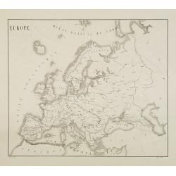
Europe.
Fine manuscript map of Europe with relief shown pictorially. Signed by the author in the lower right corner.Lower left Juillet 1852.
- $150 / ≈ €127
Date: Paris, 1852

Simori.
Portrait of Simori.Von Siebold was born in Wurtzburg, in Germany, and worked for the Dutch government as a doctor in Java. In Japan, where Von Siebold arrived in 1823 at ...
Date: Leiden, 1832-1852
Japan ten tyde van Zin-mu-ten-won 660 v.c.
Showing Japan 660 B.C. Japan was known as "Jama-to v. Aki-Tsu-Sima". The southern tip of Korea is shown and labeled "Kan", the island of Tsushima is l...
Date: Leiden, 1832-1852
![Dépt. De L'Aude. N°10. [ Carcassonne ]](/uploads/cache/27089-250x250.jpg)
Dépt. De L'Aude. N°10. [ Carcassonne ]
Map of the Aude region, centered on the town of Carcassonne. Reaching to the right till the Mediterranean.Lovely map from one of the last decorative atlases of the ninete...
Date: Paris, A. Combette, 1852
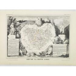
Dépt. De La Haute Loire. N°42.
Map of the Upper Loire region in France.Lovely map from one of the last decorative atlases of the nineteenth century.The rather simple map is framed by medallion portrait...
- $50 / ≈ €42
Date: Paris, A. Combette, 1852
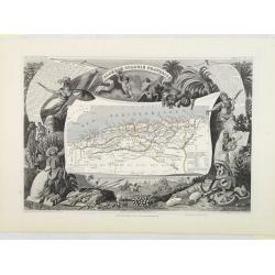
Algérie, Colonie Française. N°87.
Map of Algeria.Lovely map from one of the last decorative atlases of the nineteenth century.The rather simple map is framed by medallion portraits and coats of arms, and ...
Date: Paris, A. Combette, 1852
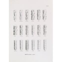
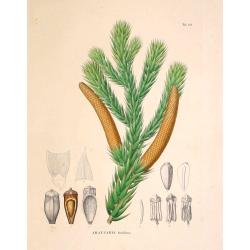
ABIETUM phyllulae et pulvini.s. Tab. 137.
From his famous work 'Flora Japonica'. Von Siebold was born in Würtzburg, in Germany, and worked for the Dutch government as a doctor in Java. In Japan, where Von Siebol...
- $75 / ≈ €64
Date: Leiden, 1852
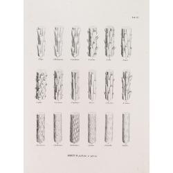
ABIETUM phyllulae et pulvini.s. Tab. 137.
From his famous work 'Flora Japonica'. Von Siebold was born in Würzburg, Germany, and worked for the Dutch government as a physician in Java. In Japan, where Von Siebold...
Date: Leiden, 1852
![[No title] Boats on the beach.](/uploads/cache/28962-250x250.jpg)
[No title] Boats on the beach.
Attractive lithography showing a typical Dutch sunset scene with a boat and windmill, lithographed by Petrus Paulus Schiedges (Den Haag 7 June 1813 - Den Haag 1 December ...
- $80 / ≈ €68
Date: The Hague, 1852
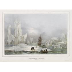
La Corvette la recherche au milieu des glaces.
Beautiful lithograph by A. Mayer and Bayot of the corvette "La recherche" surrounded by Ice. Published by Arthus-Bertrand and Lemercier in Paris.From Joseph Pau...
Date: Paris. Arthus-Bertrand, 1838-1852
Factorij der Nederlanders op Firato.. 1609-1641.
Bird's-eye view of Hirado, a trading post of the V.O.C. from 1609 until 1641.Von Siebold was born in Wurzburg, in Germany, and worked for the Dutch government as a doctor...
- $1500 / ≈ €1271
Date: Leiden, 1832-1852

(The City And Harbour Of Sydney From Near Vaucluse.)
One of the most sought after views of the city and harbour of Sydney seen from Near Vaucluse, 1852. Magnificent hand-colored tinted lithograph and finished by gum-Arabic....
Date: London, J. Hogarth, 1852
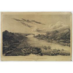
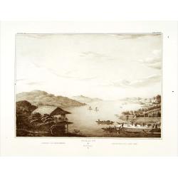
Gezigt op de haven en de baai van Nagasaki.
A very rare birds-eye view showing Deshima and Nagasaki bay. Von Siebold was born in Würtzburg, in Germany, and worked for the Dutch government as a doctor in Java. In J...
Date: Leiden 1832-1852
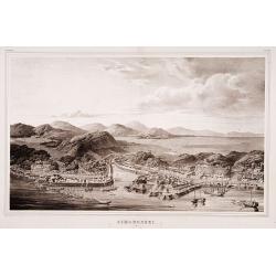
Simonoseki.
Bird's-eye view of Simonoseki, an important trading post in earlier times. Von Siebold was born in Wurtzburg, in Germany, and worked for the Dutch government as a doctor ...
- $1500 / ≈ €1271
Date: Leiden, 1832-1852

Map of the Great Salt Lake And Adjacent Country in the Territory Of Utah. Surveyed in 1849 and 1850, under the orders of Col. J.J. Abert ...
Map of the Great Salt Lake And Adjacent Country in the Territory Of Utah. Surveyed in 1849 and 1850, under the orders of Col. J.J. Abert .. by Capt. Howard Stansbury .. a...
Date: Ackerman, New York, 1852
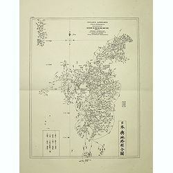
Insularum Japonicarum tabulae geographicae secundum opus NIPPON JO TSI RO TEI SEN TSU Tab. I Kiusui Insularum. . .
Fine map of the island if Kyushu, together with Tsushima Island with the bay of Nagasaki where in 1641 the man-made island of Deshima, trading post of the V.O.C. was est...
- $1000 / ≈ €847
Date: Leiden, 1832-1852
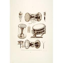
Muzijkinstrumenten.
Showing Japanese drums.Von Siebold was born in Würzburg, in Germany, and worked for the Dutch government as a doctor in Java. In Japan, where Von Siebold arrived in 1823...
- $200 / ≈ €169
Date: Leiden, 1832-1852