Browse Listings
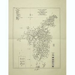
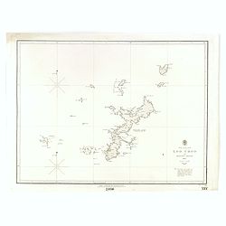
Insularum Japonicarum tabulae geographicae secundum opus NIPPON JO TSI RO TEI SEN TSU Tab. I Kiusui Insularum. . .
Fine map of the island if Kyushu, together with Tsushima Island with the bay of Nagasaki where in 1641 the man-made island of Deshima, trading post of the V.O.C. was est...
- $1000 / ≈ €847
Date: Leiden, 1832-1852
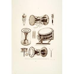
Muzijkinstrumenten.
Showing Japanese drums.Von Siebold was born in Würzburg, in Germany, and worked for the Dutch government as a doctor in Java. In Japan, where Von Siebold arrived in 1823...
- $200 / ≈ €169
Date: Leiden, 1832-1852
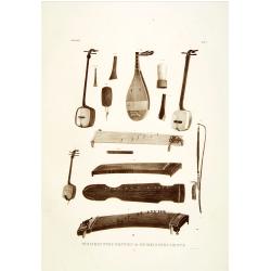
Muzijkinstrumenten.
Showing several Japanese string musical instruments, a.o.: Samisen and Kokiu.Von Siebold was born in Wurtzburg, in Germany, and worked for the Dutch government as a docto...
- $200 / ≈ €169
Date: Leiden, 1832-1852
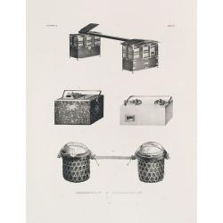
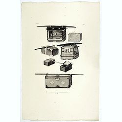
REISGEREEDSCHAPP. REISEGERAETHSCHAFT. Tab. II.
Japanese travel chests as used in a Dutch tributary embassy to the Tokugawa’s residence.Philipp Franz von Siebold (1796-1866) was a physician, researcher and teacher wh...
- $300 / ≈ €254
Date: Leiden, 1852

MUZJIKINSTRUMENTEN. MUSIKINSTRUMENTE. Tab.VI.
Several Japanese instruments.Philipp Franz von Siebold (1796-1866) was a physician, researcher, and teacher who joined the Dutch East Indian army and traveled to Japan on...
- $350 / ≈ €296
Date: Leiden, 1852

Volksphysionomien.
Showing farm and city boy and girl in typical dress and haircut.Von Siebold was born in Wurzburg, in Germany, and worked for the Dutch government as a doctor in Java. In ...
- $200 / ≈ €169
Date: Leiden 1832-1852

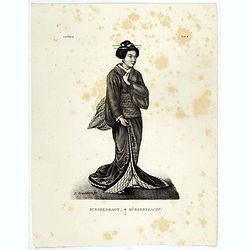
De Vrouw - Die Gemahlin der Sjogun.
Showing the wife of a shogun in typical kimono and hair cut. A Shogun and daimyo often had several wives to ensure the birth of an heir.Von Siebold was born in Wurzburg, ...
- $200 / ≈ €169
Date: Leiden 1832-1852

Een Japansch Meisje - Ein japanisches Madchen.
Portrait of a Japanese girl. Lithography made after a drawing made to nature by de Villeneuve., Von Siebold was born in Wurzburg, in Germany, and worked for the Dutch gov...
- $200 / ≈ €169
Date: Leiden 1832-1852
![Burgerdragt. [Japanese citzen in typical dress]](/uploads/cache/39349-250x250.jpg)
Burgerdragt. [Japanese citzen in typical dress]
Showing a Japanese citizen in a typical dress.Von Siebold was born in Wurzburg, in Germany, and worked for the Dutch government as a doctor in Java. In Japan, where Von S...
- $150 / ≈ €127
Date: Leiden 1832-1852

Staatiekleeding.
Showing a Japanese man's in official dress.Von Siebold was born in Wurzburg, in Germany, and worked for the Dutch government as a doctor in Java. In Japan, where Von Sieb...
- $175 / ≈ €148
Date: Leiden 1832-1852
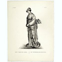
Eene Voorname Dame.
Showing a wife of a high-ranking person dressed in typical kimono. The tenno, kugyo (court officials), shogun and daimyo often had several wives to ensure the birth of an...
- $200 / ≈ €169
Date: Leiden 1832-1852
Burgerdragt.
Showing a Japanese citizen woman in kimono.Von Siebold was born in Wurzburg, in Germany, and worked for the Dutch government as a doctor in Java. In Japan, where Von Sieb...
- $200 / ≈ €169
Date: Leiden 1832-1852
![Eene Vorstin. [Japanese Empress]](/uploads/cache/39353-250x250.jpg)
Eene Vorstin. [Japanese Empress]
Showing Japanese Empress in kimono.Von Siebold was born in Wurzburg, in Germany, and worked for the Dutch government as a doctor in Java. In Japan, where Von Siebold arri...
- $200 / ≈ €169
Date: Leiden 1832-1852
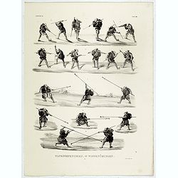
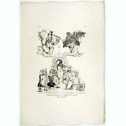
Wapenoefeningen - Tab XXIV. (Japanese martial art techniques)
Showing Japanese scenes of different martial art techniques.Von Siebold was born in Wurzburg, in Germany, and worked for the Dutch government as a doctor in Java. In Japa...
- $200 / ≈ €169
Date: Leiden 1832-1852
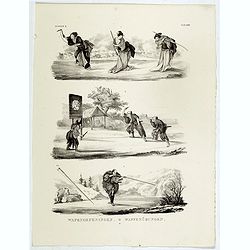
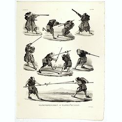
Wapenoefeningen - Tab XXIII. (Kendo training)
Showing Japanese scenes of Kendo training.Von Siebold was born in Wurzburg, in Germany, and worked for the Dutch government as a doctor in Java. In Japan, where Von Siebo...
- $300 / ≈ €254
Date: Leiden 1832-1852
Wapenoefeningen - Tab XXII. (Kendo training)
Showing Japanese Kendo training.Von Siebold was born in Wurzburg, in Germany, and worked for the Dutch government as a doctor in Java. In Japan, where Von Siebold arrived...
- $300 / ≈ €254
Date: Leiden 1832-1852
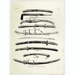
Wapenen.
Showing Japanese swords.Von Siebold was born in Wurzburg, in Germany, and worked for the Dutch government as a doctor in Java. In Japan, where Von Siebold arrived in 1823...
- $200 / ≈ €169
Date: Leiden 1832-1852
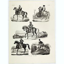
Ruiters.
Showing Japanese types of cavaliers.Von Siebold was born in Wurzburg, in Germany, and worked for the Dutch government as a doctor in Java. In Japan, where Von Siebold arr...
- $150 / ≈ €127
Date: Leiden 1832-1852
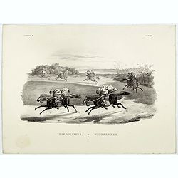
Harddravers.
Showing a Japanese scene of cavaliers training.Von Siebold was born in Wurzburg, in Germany, and worked for the Dutch government as a doctor in Java. In Japan, where Von ...
- $200 / ≈ €169
Date: Leiden 1832-1852

Een Veldheer.
Showing a Japanese cavalier.Von Siebold was born in Wurzburg, in Germany, and worked for the Dutch government as a doctor in Java. In Japan, where Von Siebold arrived in ...
- $300 / ≈ €254
Date: Leiden 1832-1852

Hofdragt.
Showing different Japanese men's clothing at court.Von Siebold was born in Wurzburg, in Germany, and worked for the Dutch government as a doctor in Java. In Japan, where ...
- $250 / ≈ €212
Date: Leiden 1832-1852
Reisgereedschapp - Reisegeraethschaft.
Showing Japanese travel chests as used during a Dutch tributary embassy to the Tokugawa’s residence.Von Siebold was born in Wurzburg, in Germany, and worked for the Dut...
- $300 / ≈ €254
Date: Leiden 1832-1852
Muzik en dans.
Showing Japanese scenes of music and dance.Von Siebold was born in Wurzburg, in Germany, and worked for the Dutch government as a doctor in Java. In Japan, where Von Sieb...
- $150 / ≈ €127
Date: Leiden 1832-1852
![Wapenrusting. [Samurai armour]](/uploads/cache/39403-250x250.jpg)
Wapenrusting. [Samurai armour]
Showing Japanese Samurai armour.Von Siebold was born in Wurzburg, in Germany, and worked for the Dutch government as a doctor in Java. In Japan, where Von Siebold arrived...
- $300 / ≈ €254
Date: Leiden 1832-1852
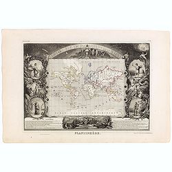
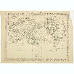
Planisphère.
One of the last decorative maps of the area. In side panels representations of the four seasons. In original o.l. color, from his "Atlas Universel Illustré". T...
Date: Paris, A. Combette, 1852
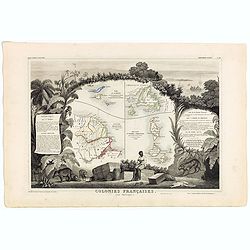
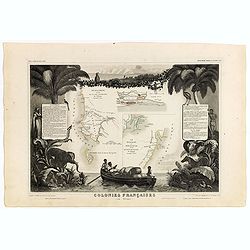
Colonies Françaises (en Amérique). N°92.
A very decorative 19th century map showing the islands of St Martin, St Pierre et Miquelon and Terra Nova. Includes also Guyana. The map is surrounded by portraits, anima...
Date: Paris, A. Combette, 1852
Colonies Françaises (en Afrique). N°91.
Handsome map divided into two sections shows a section of the coast of French West Africa titled 'Senegambie' (Senegal & Gambia) with a drawing of the Senegal River a...
Date: Paris, A. Combette, 1852
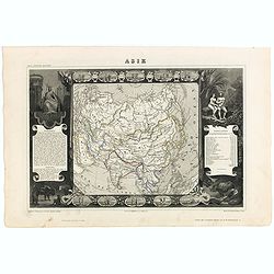
Carte de l'Asie.
Map of Asia framed by vignettes depicting costumes of the various peoples of Asia, Adam and Eve, and several exotic animals. Interesting population chart at right totalin...
Date: Paris, A. Combette, 1852
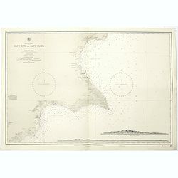
Cyprus south east coast Cape Kiti to Cape Eloea.
An British Admiralty chart of Cyprus south east coast. A highly corrected version of Admiralty chart 971 originally published 15th February 1866 under the Superintendence...
- $100 / ≈ €85
Date: London, 1852
![Dépt. du Morbihan. N°. 55. [ Morbihan, Belle-Ile ]](/uploads/cache/43041-250x250.jpg)
Dépt. du Morbihan. N°. 55. [ Morbihan, Belle-Ile ]
Map of the Morbihan region in Brittany. Including "Belle-Ile".Lovely map from one of the last decorative atlases of the nineteenth century.The rather simple map...
Date: Paris, A. Combette, 1852
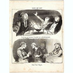
Paris Qui Boit - Complete serie of 6 lithographes.
Second state (of 2), six sheets with on each sheet two scenes, complete series "Paris Qui Boit". Text below image : - Amateurs de moka en train de déguster ave...
Date: Paris, after 1852
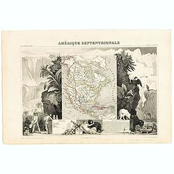
Amerique Septentrionale.
Beautiful map with the United States extending into present day Canada, Russia in control of Alaska and Mexico's northern border according to the Treaty of 1810. Surround...
- $175 / ≈ €148
Date: Paris, A. Combette, 1852
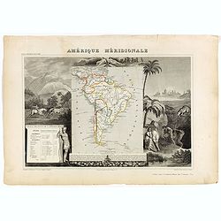
Amérique Méridionale.
Map of South America.Lovely map from one of the last decorative atlases of the nineteenth century.The rather simple map is framed by horses, Indians, jaguars, tapirs, and...
Date: Paris, A. Combette, 1852
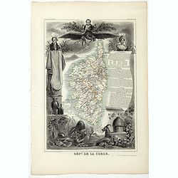
Dépt. De La Corse. N°19.
Map of the Corsica island.Lovely map from one of the last decorative atlases of the nineteenth century.The rather simple map is framed by elaborate border showing regiona...
- $150 / ≈ €127
Date: Paris, A. Combette, 1852
![[Collection of six maps of Australia and New Zealand.]](/uploads/cache/48412-250x250.jpg)
[Collection of six maps of Australia and New Zealand.]
Collection of maps including 6 engraved maps by 19th century German, French and English cartographers depicting Australia and New Zealand.This made to order atlas contain...
Date: Germany, 1832-1852
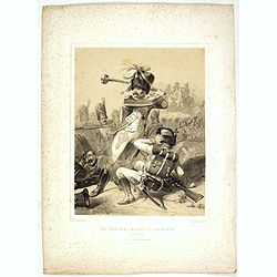
Le Tambour Major de la garde - Wagram 1809
Militaria plate depicting a war scene and a man defending himself from another soldier threatening him. Lithographed by Vernier Ch. and printed by Auguste Bry, 114 rue du...
Date: Paris, chez Bequet, 1852
![ISLA DE CUBA [with 2 maps] Plano Pintoresco De La Habana con los numeros de las casas B. May y Ca. 1853. (with) Inset map Puerto y Cereanias De La Habana. (with) 14 views of Havana & prominent buildings.](/uploads/cache/36720-250x250.jpg)
ISLA DE CUBA [with 2 maps] Plano Pintoresco De La Habana con los numeros de las casas B. May y Ca. 1853. (with) Inset map Puerto y Cereanias De La Habana. (with) 14 views of Havana & prominent buildings.
Lithographic town-plan surrounded with views of the city of Havana including the "Fuente De La India En El Paseo De Isabel 2a." and "Vista Gral De La Haban...
Date: Havana, 1853
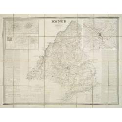
Madrid por el Teniente Coronel, Capítan de Ingenieros D. Francisco Coello. Las notas estadisticas é historicas han sido escritas por D. Pascual Madoz. Madrid 1853.
Second edition of this important and very detailed map of the region of Madrid prepared by Francisco Coello (1822 - 1898) and improved by Pascual Madoz (1806 - 1870). Eng...
- $400 / ≈ €339
Date: Madrid, 1853

Kronstat From The Russian Survey . . .
Scarce chart of the Island of Kronstat, the primary defensive position for the Russian Navy in defense of Russia's Czarist Capital of St. Petersburg.Published on the eve ...
- $500 / ≈ €424
Date: London, 1853
![Le Sacre Hagard [Haggard-falcon]](/uploads/cache/44315-250x250.jpg)
Le Sacre Hagard [Haggard-falcon]
A beautiful elephant folio sized colored lithograph of a Hagard Falcon, taken from the famous book on Falconry Traite de Fauconnerie by Schlegel and A.H. Verster van Wulv...
Date: Leiden, 1844-1853

The town & harbour of Sevastopol with the batteries & approaches. . .
Rare colored linen backed map showing the harbour and town of Sevastopol, with soundings. In upper left corner a inset map (65x150mm) of the Black Sea. In bottom part a l...
Date: London, March 27th, 1854

The Crimea, chiefly from surveys made by order of the Russian government. . .
Map of Crimea and the Sea of Azov. In lower right corner two inset maps showing Sebastopol inlet and harbour and a second one with the Black Sea. This second maps shows t...
Date: London, 1854
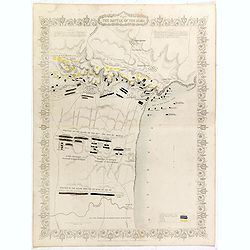
Plan of the battle of Alma.
Fine plan drawn and engraved by John Rapkin "from English and French Official Documents" Published 1858 by the London Printing and Publishing Co., London. Shows...
- $150 / ≈ €127
Date: London, 1854
Siege of Sebastopol.
Detailed map of the Siege of Sebastopol. After the Battle of the Alma, the Allies proceeded to Sebastopol and commenced the Siege on September 26th, 1854. This is a steel...
- $150 / ≈ €127
Date: London, 1854
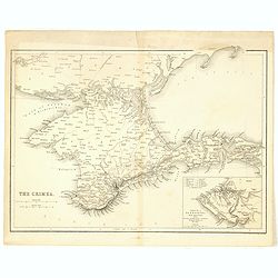
The Crimea.
Map of Crimea and the Sea of Azov. In lower right corner inset map showing Sebastopol region.
- $50 / ≈ €42
Date: London, 1854
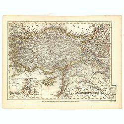
Die Asiatische Turkey 1854.
Steel engraved map, hand colored in outline when it was published. The detailed map shows the Asian part of Turkey, most of Syria, Iraq, Cyprus and the southern reaches o...
- $70 / ≈ €59
Date: Hildburghausen, Bibliograph Institut,1854
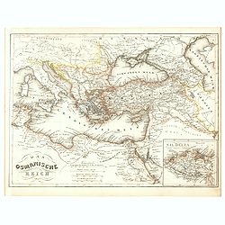
Das Osmanische Reich 1854.
From Meyer's Neuester Zeitungs Atlas. The map is well engraved in the German style with plenty of detail but minimal decoration. Inset map of the Nile Delta.
- $40 / ≈ €34
Date: Heidelberg, 1854
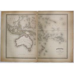
Océanie dressée par A.H. Dufour géographe.
Wall-sized map (87x117cm) in two sheets prepared by Adolphe Hippolyte Dufour, giving good detail to Australia and New Zealand, due to extensive discoveries of the French ...
- $1200 / ≈ €1016
Date: Paris, 1854
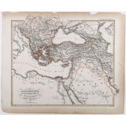
Das osmannische Reich und dessen Schutz-Staaten, nach seiner grossten Ausdehnung im XVIIten Jahrhundert.
Karl von Spruner's historical map of the Ottoman empire at the end of the 17th century. Showing Bosnia to Egypt and as far east as Persia. Including northern part of the ...
- $175 / ≈ €148
Date: Gotha, J.Perthes, ca. 1854
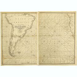
A general chart of the South Atlantic Ocean Drawn by J.W.Norie hydrographer. Revised & Corrected 1854.
A 2-sheet chart of the South Atlantic Ocean, showing the coast of South America from the mouth of the Amazon to Quito in Peru. The right hand part showing Africa's coast ...
- $600 / ≈ €508
Date: London, 1854
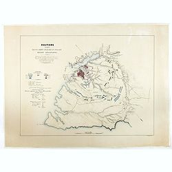
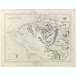
Positions occupées par les armées françaises et anglaises devant Sevastopol.
Map of the French and English armies positions in Sebastopol.Read more about The Crimean War - The Siege of Sevastopol. [+]
- $350 / ≈ €296
Date: Paris, 1854
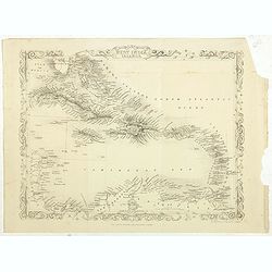
West India Islands.
Map of the West Indies, published by "The London Printing and Publishing Company". Drawn and engraved by John Rapkin.
- $75 / ≈ €64
Date: London, 1854
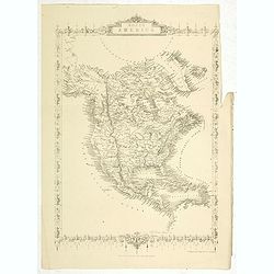
North America.
Map of North America, published by "The London Printing and Publishing Company". Drawn and engraved by John Rapkin.
- $100 / ≈ €85
Date: London, 1854
The World on Mercator's projection.
World map in Mercator-projection, published by "The London Printing and Publishing Company". Drawn and engraved by John Rapkin.
- $110 / ≈ €93
Date: London, 1854
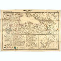
Carte d'Orient par Kraminski ingénieur.
Large map of Orient, with an insert of four maps (Constantinople plan - Map of Europe - Map of Russia - Plan of Baltic sea). With flags in the lower left part. color key ...
Date: Paris, 1854
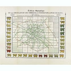
Tableau synoptique de la circulation des omnibus à correspondances de Paris.
Synoptic table of the circulation of omnibuses with connections of Paris indicating at first sight the resources presented by the one hundred and sixty-seven connections ...
- $750 / ≈ €635
Date: Paris, ca. 1854
![[Title page Atlas National Illustré . . .]](/uploads/cache/47736-250x250.jpg)
[Title page Atlas National Illustré . . .]
Title page of Atlas national illustré des 86 département de la France, divisé par arrondissements et en commune by Victor Levasseur in 1854, and published by A. Combet...
- $175 / ≈ €148
Date: Paris, 1854

(Lübeck) Lvbeca vrbs. imperialis libera. civitatvm. Wandalicarvm. . . .
Impressive, more than 3 meters wide panoramic town view after a woodblock engraving from Elias Diebel, initially made in 1552. Of this original woodblock, Bachmann mentio...
Date: Germany, c. 1855

The Crimea by James Wyld Geographer to the Queen & H.R.H. Prince Albert.
Fourth edition of this folding map of the Crimea. In upper right corner an inset map of the areas around the Black Sea; "The Town & Harbor of Sevastopol with the...
Date: London, 1855
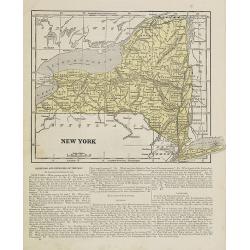
New York.
Map of New York. From Sidney E. Morse''s: System of Geography for the use of schools , published by Harper and brothers, 329 Pearl Street, New York.An 150 years old map w...
- $30 / ≈ €25
Date: New York, 1855
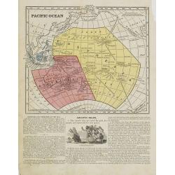
Pacific Ocean.
Map of the Pacific Ocean with its Polynesian islands, and New Zealand and Australia. From Sidney E. Morse''s: System of Geography for the use of schools , published by Ha...
- $30 / ≈ €25
Date: New York, 1855
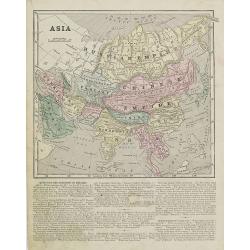
Asia.
Map of Asia encompassing the Russian Empire, the Chinese Empire, India Persia, Tartary, Turkey, and Arabia. From Sidney E. Morse''s: System of Geography for the use of sc...
Date: New York, 1855
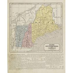
Maine, New Hampshire and Vermont.
Map of Maine, New Hampshire and Vermont.. On the verso, a world map of North and South America with its northern and southern hemispheres. From Sidney E. Morse''s: System...
Date: New York, 1855

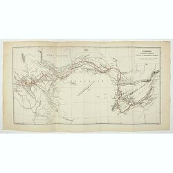
Military map of the countries between Odessa & Perekop with the stations of the Russian forces.
Rare colored linen-backed map showing Russian troop positions and Odessa Batteries. On the inside of the cover a list of "Wyld's list of recent publications : seat o...
Date: London, ca. 1855
Accampamenti, Trinceramenti, ed Operazioni di Assedio...
Detailed plan of the Allied siege of Sebastopol in 1854-1855 during the Crimean War, showing the allied French, English and Turkish positions, and those of the Russians, ...
- $400 / ≈ €339
Date: Naples, 1855
North Pacific Ocean LOO CHOO and adjacent Islands 1855.
Large scale chart of Okinawa in the Japan Sea. With scale and vignette of Typographical office. Map nr. 2416.An interesting note in lower right "The coast line of al...
- $300 / ≈ €254
Date: London, 1855
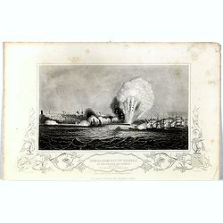
Bombardment of Odessa by the English and French April 22 1854, explosion on the imperial mole . . .
Scene from the Crimea war, showing a bombardment of Odessa, 22nd April 1854 (during Crimean War, 1853-56), by English and French forces, explosion imperial mole (breakwat...
- $55 / ≈ €47
Date: London, 1855
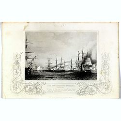
Bombardment of Odessa by the English and French April 22 1854, The boats of the British Fleet going to the French steamer 'Vauban' . . .
Scene from the Crimea war, showing the bombardment of Odessa, 22nd April 1854 (during Crimean War, 1853-56), engraving by G. Greatbach after drawing by H.W. Nicholls, c. ...
- $30 / ≈ €25
Date: London, 1855
Issidori mansiones parthicae a seleucia ad Alexandropolin archosiae.
Map showing Iran and the southern tip of the Caspian Sea. Published in 1855 by Karl Müller as part of his work "Geographi Graeci Minores".Muller wrote in Latin...
- $35 / ≈ €30
Date: Paris, Ambrosio Firmin Didot, 1855

Carte d'unne partie de l'Arabie Septentrionale Pour suivre les Voyages de Mr. G.A. Vallin. . .
This is the original hand-drawn map by Victor Adolphe Malte-Brun of "Carte d'unne partie de l'Arabie Septentrionale Pour suivre les Voyages de Mr. G.A. Wallin",...
Date: Paris, November 1855
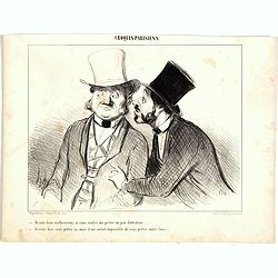
Croquis Parisiens - ''Je suis bien malheureux, si vous voulez me prêter un peu d'attention.... - Je veux bien vous prêter ça, mais il me serait impossible de vous prêter autre chose.''
Second state (of 3), with text. From "Croquis Parisiens". Text below image : "Je suis bien malheureux, si vous voulez me prêter un peu d'attention....&quo...
- $75 / ≈ €64
Date: Paris, after 1855
Croquis Parisiens - ''Je suis bien malheureux, si vous voulez me prêter un peu d'attention.... - Je veux bien vous prêter ça, mais il me serait impossible de vous prêter autre chose.''
Second state (of 3), with text. From "Croquis Parisiens". Text below image : "- Queu poisson!... - Il est tout de même biau... mais y n'doit pas être bon...
- $75 / ≈ €64
Date: Paris, after 1855
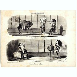
Croquis Parisiens - ''Pose de l'homme de la nature. - Pose de l'homme civilisé.''
Second state (of 3), with text. From "Croquis Parisiens". Text below image : "Pose de l'homme de la nature. - Pose de l'homme civilisé." ( - Pose of ...
- $75 / ≈ €64
Date: Paris, after 1855

Croquis Parisiens - ''Ça sent le jasmin!....... - Ça ne sent pas la violette!......''.
Second state (of 3), with text. From "Croquis Parisiens". Text below image : "- Ça sent le jasmin!....... - Ça ne sent pas la violette!......" ( - I...
- $75 / ≈ €64
Date: Paris, after 1855
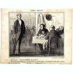
Croquis Parisiens - ''Est-ce le garçon..... faut-il lui demander une assiette? ...''
Second state (of 3), with text. From "Croquis Parisiens". Text below image : "- Est-ce le garçon..... faut-il lui demander une assiette?... - Ma foi, je n...
- $75 / ≈ €64
Date: Paris, after 1855
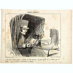
Croquis Parisiens - '' - Qu'a donc ma femme à regarder ce cabriolet avec tant d'attention... je croyais qu'elle ne se connaissait pas en voiture... moi, je n'y trouve rien d'extraordinaire, à ce ...''
Second state (of 3), with text. From "Croquis Parisiens". Text below image : "-- Qu'a donc ma femme à regarder ce cabriolet avec tant d'attention... je cr...
- $75 / ≈ €64
Date: Paris, after 1855

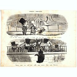
Croquis Parisians - ''A LA RECHERCHE D'UN DINER. - Monsieur ne dine pas chez lei.. - Pas possible!... --- Oh! pour le coup, on dine dans cite Maison ci!
Second state (of 3), with text. From "Croquis Parisiens". Text below image :A LA RECHERCHE D'UN DINER. - Monsieur ne dine pas chez lui.. - Pas possible!... --- ...
- $150 / ≈ €127
Date: Paris, after 1855
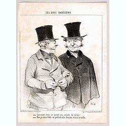
Ces Bons Parisiens - Comment, vous ne portez pas encore de talma? . . . - Non, je reste fidèle au paletot, cela dessine mieux la taille. (364)
Second state (of 2), with text. From "Ces Bons Parisiens". Text below image : - Comment, vous ne portez pas encore de talma. . . . - Non, je reste fidèle au pa...
Date: Paris, after 1855
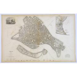
Venice.
A lovely steel engraved plan, on 2 sheets, of Venice by the Society for the Diffusion of Useful Knowledge (SDUK). This English philanthropic enterprise was entirely devot...
Date: London, 1855
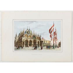
Basilique S. Marc.
St Mark’s Basilica, lithographed in Venice by G. Brizeghel, published here with French captions in "Album delle principali vedute di Venezia". In original co...
Date: Venice, c.1855