Browse Listings
![Vue d'un Rocher troué de la Nouvelle Zélande. [Tome III Pl. 8.]](/uploads/cache/26112-250x250.jpg)
Vue d'un Rocher troué de la Nouvelle Zélande. [Tome III Pl. 8.]
A view of a New Zealand landscape and seascape through a hollow rock. Engraved by Demouchy. From the French edition of James Cook's first voyage entitled Relation des voy...
Date: Paris, 1773
![Manière dont on expose les morts à Otahiti. [Tome II Pl. 16.]](/uploads/cache/26113-250x250.jpg)
Manière dont on expose les morts à Otahiti. [Tome II Pl. 16.]
A view of a Tahitian funeral home in a beautiful landscape. Engraved by Demouchy. From the French edition of James Cook's first voyage entitled Relation des voyages entre...
Date: Paris, 1773

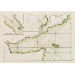
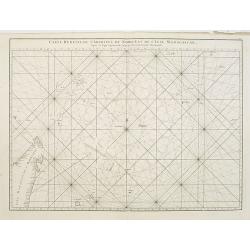
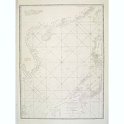
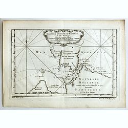
Carte de la Coste d'Arabie.
Uncommon issue of this very nice map of the Arabian peninsula. Depicted is Saudi Arabia, Red Sea and the Persian Gulf.With French text in title cartouche and an additiona...
Date: Amsterdam, 1773
![Vue d'un Rocher troué de la Nouvelle Zélande. [Tome III Pl. 8.]](/uploads/cache/29073-250x250.jpg)
Vue d'un Rocher troué de la Nouvelle Zélande. [Tome III Pl. 8.]
A view of a New Zealand landscape and seascape through a hollow rock. Engraved by Demouchy. From the French edition of James Cook's first voyage entitled Relation des voy...
- $75 / ≈ €64
Date: Paris, 1773
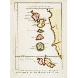
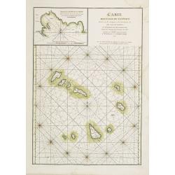
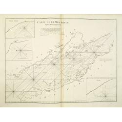
Carte Particuliere des Isles Moluques. . .
A very nice map centered on the island of the Moluccas.Title in French and in Dutch underneath the map.
Date: Amsterdam, 1773
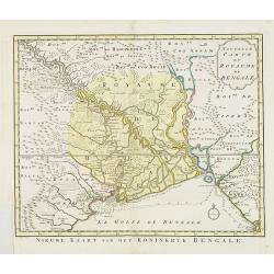
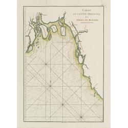
Nouvelle carte du Royaume de Bengale.
Uncommon issue of this detailed map of Bangladesh with the Ganges delta, including Calcutta. Giving great detail with trade routes, European trade settlements, etc. Prepa...
- $380 / ≈ €322
Date: Amsterdam, 1773
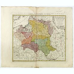
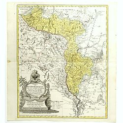
Mappa Geographica Regni Poloniae ex novissimis quotquot sunt mappis specialibus composita et al L.L. Stereographicae projectionis revocata a Tob. Mayero. . . .
Late Tobias Mayer detailed map Polish edition, updated in order to show the borders of the kingdom of year 1772 after the division of the territory.Mayer's map extends fr...
- $750 / ≈ €636
Date: Nuremberg, 1773
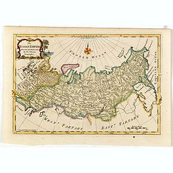
The Russian Empire, from the Best Authorities, by Thos. Kitchin, Geographer.
Showing the Asian part of Russia, with interesting note to a coast line north of Siberia "Land seen in 1723", likely referring to Vitus Bering (1681–1741), wh...
- $150 / ≈ €127
Date: London, c. 1773
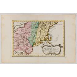
Carte de la Nouvelle Angleterre, Nouvelle York et Pensilvanie / Pour servir à l'Histoire Générale des Voyages.
Uncommon edition of this accurate map the east coast from Delaware River till Main.Left hand corner Lake Ontario. In lower right engraved "38."From Atlas Portat...
Date: Amsterdam, 1773
Carte de la province de Quan-tong, ou Lyau-tong et du Royaume de Kau-li ou Corée. . . / Kaart van t' Landschap Quan-Tong . . .
Uncommon issue of this fine map of Korea. The map is of interest for the use of East Sea, the sea between Korea and Japan, here called "Mer de Corée.Decorative titl...
Date: Paris, 1749-1773
Neue und vollständige Topographie der Eidgnossschaft, in welcher die in den dreyzehen und zugewandten auch verbündeten Orten und Landen dermal befindliche Städte, Bischthümer, Stifte, Klöster, Schlösser, Amts-Häuser, Edelsitze und Burgställe...
The first edition of Herrliberger's work on the topography of Switzerland. - The rarest book on Switzerland rarely found complete.Illustrated with an engraved allegorical...
- $5500 / ≈ €4664
Date: Zurich, Johann Kaspar Ziegler, 1754-1773
Mappa Geographica Regni Poloniae ex novissimis quot quot sunt mappis. . .
A map of Poland, Lithuania and Belarus, first published in 1750 by Homann Heirs, and now re-issued in 1773. Coastline includes all between Riga and Gdansk. Map is based o...
Date: Nuremberg, 1773
![[Set of a title and frontispiece from Hydographie Françoise. . . Vol 1 ]and 2]](/uploads/cache/47733-250x250.jpg)
[Set of a title and frontispiece from Hydographie Françoise. . . Vol 1 ]and 2]
Very decorative title page and frontispiece of Hydographie Françoise, published by Jacques-Nicolas Bellin in 1772 and 1773. The title page was engraved in 1765 and is da...
- $750 / ≈ €636
Date: Paris, 1773
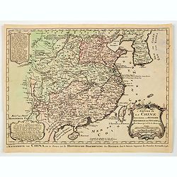
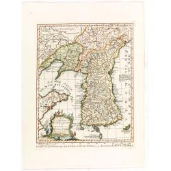
L'Empire de La Chine../ 't Keizerryk van China..
An attractive map of China with Korea and Taiwan (I.Tay-wan, ou Formosa) and "Mer de Coree'. There are decorative title cartouches in three corners of the map. The u...
- $200 / ≈ €170
Date: The Hague, 1773

Kerk te Asten in Peelland.
"Etching of the church of Asten, from ""Het Verheerlijkt Nederland of Kabinet van hedendaagsche gezichten.."" published by Isaac Tirion in Amster...
Date: Amsterdam 1745-1774

Kapel van Vlierden.
Etching of the old chapel of Vlierden (near Deurne), from Het Verheerlijkt Nederland of Kabinet van hedendaagsche gezichten.. published by Isaac Tirion in Amsterdam. Etch...
Date: Amsterdam 1745-1774
![[Insects]](/uploads/cache/09188-250x250.jpg)
[Insects]
Decorative plate from Naauwkeurige waarneemingen omtrent de veranderingen van veele insekten of gekorvene diertjes. Engraved by Ludwig Schmidt after Jablonsky. Printed by...
- $40 / ≈ €34
Date: Amsterdam, 1774

Terrae Yemen Maxima Pars, seu Imperii Imami, Principatus Kaukeban nec non ditionum Haschid u Bekil, Nehhm, Chaulan, Abu Arisch et Aden Tabula ...
South-west Arabia, with the Saudi Arabian city of Jizan south to Aden. With a fine title, cartouche. Based on a map by Carsten Niebuhr. With the name Sinus Arabicus Mare ...
Date: Augsbourg, 1774
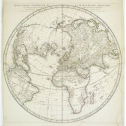
Hémisphère Supérieur de la Mappemonde projetée sur l'Horizon. . .
Hemisphere on a partial polar projection. The Northern Hemisphere (of 2) is centered on Paris emphasizing the continents. Hemisphere measures 24.5. Alaska is shown as an ...
Date: Paris, 1774
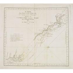
Carte d'une Partie de la Côte, de la Nle Galles Meridle depuis le Cap Tribulation jusqu'au Detroit de l'Endeavour par le Lieut. J. Cook 1770. Tome IV. Pl. 3.
Map of a part of the New galles Meridle Coastline in Australia from the Cap Tribulation to the Endeavour Detroit. This map is taken from the first French edition of Jame...
Date: Paris, 1774
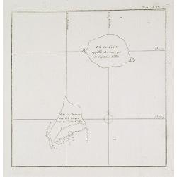
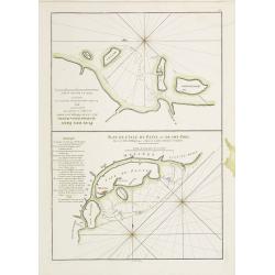
Isles des Cocos appellée Bosscaiven par le Capitaine Wallis / Isles des Traîtres appellée Keppel par le Capitaine Wallis. Tome II Pl. 4.
Chart of the Cocos and Keeppel Islands. The territory of Cocos (Keeling) Islands, also called Cocos Islands and Keeling Islands, is a territory of Australia. This map is ...
- $50 / ≈ €42
Date: Paris, 1774
![Village fortifié bâti sur un Rocher troué de la Nouvelle Zélande. [Tome III Pl. 10.]](/uploads/cache/26110-250x250.jpg)
Village fortifié bâti sur un Rocher troué de la Nouvelle Zélande. [Tome III Pl. 10.]
A view of a village fortified on a hollow rock in New Zealand. Engraved by François Godefroi. From the French edition of James Cook's first voyage entitled Relation des ...
Date: Paris, 1774
![Cession de l'Isle d'Ohahiti au Capitaine Wallis par la Reine Obéréa. [Tome II Pl. 2.]](/uploads/cache/26111-250x250.jpg)
Cession de l'Isle d'Ohahiti au Capitaine Wallis par la Reine Obéréa. [Tome II Pl. 2.]
Queen Oberea's transfer ceremony to Captain Wallis on Tahiti.Engraved by François Godefroi. From the French edition of James Cook's first voyage entitled Relation des vo...
Date: Paris, 1774
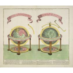
GLOBUS TERRESTRIS ad sphaeram obliquam delineatus. and the GLOBUS COELESTIS cum Astrodictico artificiali iunctus.
A very handsome, large copper engraving of a pair of globes. Ribbon style titles and German text panel at bottom.
Date: Augsburg, 1774
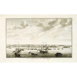
Vue de la Rade et de la Ville de Paramaribo.
A very decorative panoramic view of the town with a large Dutch vessel in the foreground. Engraved by Noach van der Meer Junior. Included in a Dutch edition of "Hist...
Date: Amsterdam, 1774
![[Title page] In medio mihi Caesar erit Templum que tenebit.](/uploads/cache/40241-250x250.jpg)
[Title page] In medio mihi Caesar erit Templum que tenebit.
Title page from "Histoire De La Campagne De M. Le Prince De Condé, En Flandre En 1674". In the center a globe surrounded with female figures. Engraved by Patas...
Date: Paris, 1774
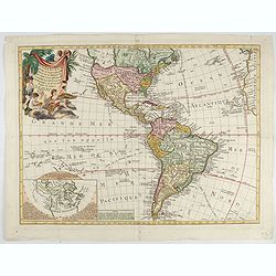
Carte D'Amerique divisée en ses principaux Pays Dressée sur les Mémoires les plus recents, et sur differents Voyages et assujettie aux Observations Astronomiques de Mrs. de l'Academie Royal des Sciences Par Mr. l'Abbe Clouet . . . 1774.
The rare 1774 edition of this fine map of the western hemisphere published by Clouet in Rouen. A later edition with the date 1787 also exists. With inset map "Carte ...
Date: Paris, 1774
![[HAWAII] - Plan de la baye de Karakakooa.](/uploads/cache/48173-250x250.jpg)
[HAWAII] - Plan de la baye de Karakakooa.
Beautiful map showing the islands forming the Hawaiian archipelago, drawn up during Cook's third voyage: Oneeheow or Ni'ihau, Atooi or Kauai, Woahoo or O'ahu, Morotoi or ...
Date: Paris, 1774
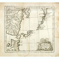
![[Haida Gwaii,] Baye Swallow . . . / Havre Byron /Côté septentrional de la plus grande des Isles de la Reine Charlotte. . . .](/uploads/cache/25888-250x250.jpg)
[Haida Gwaii,] Baye Swallow . . . / Havre Byron /Côté septentrional de la plus grande des Isles de la Reine Charlotte. . . .
Map of Swallow's Bay and a coastline profile of the Queen Charlotte Islands and Captain Byron's Heaven.Queen Charlotte Islands, with their modern name Haida Gwaii, is an ...
Date: Paris, 1774
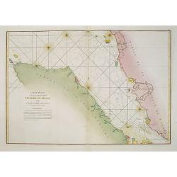
Carte Plate de la partie Septentrionale du Detroit de Malac, depuis de la rade d'Achem jusqu'a Malac.
French chart of the Island of Sumatra and the Malay Peninsula separated by the strait of Malacca in Indonesia.Latitude and longitude scales, compass rose and system of rh...
Date: Paris, ca. 1775

Carte réduite de l'Océan Oriental, depuis Le Cap de Bonne Espérance jusqu'à l'Isle Formose.
French chart covering the seas between the Cape of Good Hope and Taiwan and the West Coast of Australia. Prepared by Jacques-François L'Abbé Dicquemare (1733-1789). Lat...
Date: Paris, Brest, chez Demonville, 1775
Carte de l'Entrée du Golf de la Mer Rouge. / Plan de La Rade de Moka.
French sea chart of the entry of the Red Sea showing both the African and Arabian coasts. With two inset charts: Plan de La Rade de Moka. and one with the coasts south of...
Date: Paris, ca 1775

Carte de la Côte de Guzerat, Du Golf de Cambaye et des Côtes de Concan et De Canara.
French sea chart of West India from Gujarat to Mangalore. With inset chart Plan de la Rivière de Surate.Prepared by Jacques-François L'Abbé Dicquemare (1733-1789). La...
Date: Paris, ca 1775
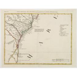
Carte de la Côte Orientale du Golfe du Bengale.
French sea chart of coast northeast of India. Latitude and longitude scales, compass rose and system of rhumb lines, soundings near coast and in bay areas.D' Après de Ma...
- $150 / ≈ €127
Date: Paris, ca 1775

A chart of the China Sea inscribed to Monsr. D'APRES de MANNEVILLETTE .. To A.Dalrymple.
This most important milestone chart is based upon the surveys made from navigational surveys by Alexander Dalrymple (1737-1808]. He was the first hydrographer of the Brit...
Date: Paris, ca 1775
Carte des Iles du Cap-Verd Dressée sur les remarques et les observations les plus exactes des Navigateurs.
French sea chart of the Cap Verde Islands, situated 570 kilometers off the coast of Western Africa.Latitude and longitude scales, compass rose and system of rhumb lines, ...
- $100 / ≈ €85
Date: Paris, Brest, chez Demonville, 1775
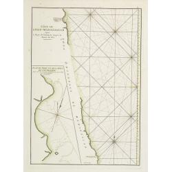
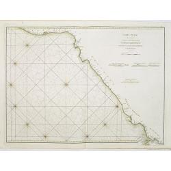
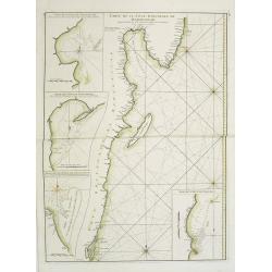
Côte de l'Isle de Madagascar depuis la Baye de Vohemare jusqu'à la pointe de l'Est. Plan du Port et de la Baye du Cap de l'Est.
French chart of the east coast of Madagascar.Latitude and longitude scales, compass rose and system of rhumb lines, soundings near coast and in bay areas.D' Après de Man...
- $100 / ≈ €85
Date: Paris, Brest, chez Demonville, 1775
Carte réduite de l'Archipel du Nord-Est de l'Ile Madagascar.
French sea chart of an archipelago off the coast of Madagascar. The northeastern coast of Madagascar is included.Latitude and longitude scales, compass rose and system of...
- $100 / ≈ €85
Date: Paris, Brest, chez Demonville, 1775
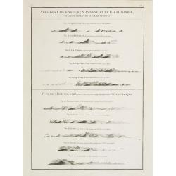
Vues des Cap d'Aden, de St. Antoine, et de Bab-El-Mandeb, sur la Côte Méridionale de l'Arabie Heureuse. Vues de l'Isle de Socotra
Coast profiles near Cape Aden in Yemen and in the lower part coastal profiles near Socotra, an island east of the Horn of Africa and 380 kilometers (240 mi) south of the ...
- $250 / ≈ €212
Date: Paris, Brest, chez Demonville, 1775
Carte Plate qui comprend La partie septentrionale de LA Cöte de Coromandel et les Côtes de Golconde , D' Orcha et de Bengale.
French chart of Coromandel in India. West to the top.Latitude and longitude scales, compass rose and system of rhumb lines, soundings near coast and in bay areas.D' Aprè...
- $150 / ≈ €127
Date: Paris, Brest, chez Demonville, 1775
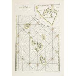
Carte des Isles Nicobar... (with) Plan particulier du Port compris entre les Isles Nacaveri, Souri, et Tricutte.
French chart of Isles of Nicobar in Gulf of Bengal near Birmanie and Sumatra. Prepared by Jacques-François L'Abbé Dicquemare (1733-1789). Latitude and longitude scales,...
Date: Paris, Brest, chez Demonville, 1775
Plan des Isles Querimbo, Oybo, et Matemo / Plan de l'Ile de Patte et de son Port.
French sea chart of Isles Patte, Querimbo, Oybo, Matemo on East coast of Madagascar. Latitude and longitude scales, compass rose and system of rhumb lines, soundings near...
- $75 / ≈ €64
Date: Paris, Brest, chez Demonville, 1775

Carte de la Baye et du Port de Trinquemalay dans L'Isle de Ceylan.
Chart showing the bay of Trincomalee, Ceylon (Sri Lanka). Trincomalee is natural deep water port on the east coast of Sri Lanka, about 110 miles northeast of Kandy. It is...
- $250 / ≈ €212
Date: Paris, 1775
Carte de la Mer Rouge, depuis Moka jusqu'a Gedda.
Chart of the Red Sea. With 3 inset maps of Shake Omare, Goofs and Gedan.D'Après De Mannevillette (1707-1780) was one of France's first hydrographers. When the first edit...
- $450 / ≈ €382
Date: Paris, 1775
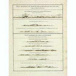
Vues diverses du fort de l'Agouade pres de l'isle de Goa . . . Sumatra . . .
French sea sea chart with 9 coastal views near Goa in India and Sumatra. The titles above the main profiles reading as following : Vues diverses du fort de l'Agouade pre...
- $200 / ≈ €170
Date: Paris, Brest, Demonville, 1775
Carte Orientale de Madacascar Depuis la Rivière Ivondrou jusqu'à Mananzari.
Large sea sea chart of the southeast coastline of Madagascar and four inset maps of the harbors and anchorage of Tamatave, Foulpointe, Teintingue und Veninguebe. Inset ma...
- $125 / ≈ €106
Date: Paris, Brest, chez Demonville, 1775
A chart of the China Sea inscribed to Monsr. D'APRES de MANNEVILLETTE .. To A.Dalrymple.
Most important milestone sea chart is based upon the surveys made from navigational surveys by Alexander Dalrymple (1737-1808]. He was the first Hydrographer of the Briti...
Date: Paris, ca. 1775
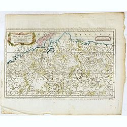
Carte de la sibérie et des Pays voisins.
An interesting detailed map of Siberia, extending from the White Sea and the Caspian Sea in the west to Irkuckoi Province .Prepared by Jacques Nicolas Bellin after Dutch ...
Date: Paris, 1738-1775
Carte des Isles Kouriles, d'après la carte Russe dréssée et gravée par Laurent.
An interesting map of the Kuril Islands, northeast from Hokkaido, Japan, to Kamchatka, Russia, separating the Sea of Okhotsk from the North Pacific Ocean.Prepared by Jacq...
Date: Paris, 1738-1775
![Planisphere celeste Septentrional. . . [together with] Planisphere celeste meridional. . .](/uploads/cache/35291-250x250.jpg)
Planisphere celeste Septentrional. . . [together with] Planisphere celeste meridional. . .
Beautiful set of celestial charts of the northern and southern skies by the well-known French astronomer, Philippe de La Hire. Surrounded by panels of astronomical notes ...
Date: Paris, ca.1775
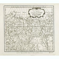
Suite de la carte de La Sibérie et le pays de Kamtschatka...
An interesting map of Siberia, with a view on Ochozk Sea. Prepared by Jacques Nicolas Bellin after Dutch sources and included in Prévost d' Exile's "Histoire des Vo...
- $75 / ≈ €64
Date: Paris, 1738-1775
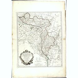
Lubomeriae Et Galliciae Regni Tabula Geographica: Cum Priv. Sac. Caes. Maiestatis Impensis Homannianorum Haeredum . . .
Rare map of the Kingdom of Galicia and Lodomeria prepared by F.L. Güssefeld, (1744-1808), who was a cartographer from Osterburg, studied at Brandenburg, worked in Weimar...
- $1500 / ≈ €1272
Date: Nuremberg, 1775
Tabula Regni Borussiae, Borussiam Orientalem exhibens . . .
Kingdom of Prussia, today part of the territory of the Polish, Lithuanian and Russian.
- $750 / ≈ €636
Date: Augsburg, 1775
Carte de la sibérie et des Pays voisins.
An interesting detailed map of Siberia, extending from the White Sea and the Caspian Sea in the west to Irkuckoi Province .Prepared by Jacques Nicolas Bellin after Dutch ...
- $50 / ≈ €42
Date: Paris, 1738-1775

Carte de la Baye et du Port de Trinquemalay Dans L'Isle de Ceylan.
French chart of the harbor of Trinquemalay on the island of Ceylon. Prepared after Samuel Cornish who was a vice admiral for the English East India company.Latitude and l...
- $350 / ≈ €297
Date: Paris, Brest, chez Demonville, 1775
Carte de la Tartarie Occidentale.
An interesting map of Tartary and northeast Asia, from Lake Baykal, Partie du Siberia in the north, Pays des Kalkas at the center, as well as Desert de Sable, and down to...
- $95 / ≈ €81
Date: Paris, ca. 1775
Carte du Détroit de Waeigats ou de Nassau.
An interesting map of the Northern Passage in Russia. Prepared by Jacques Nicolas Bellin after Dutch sources and included in Prévost d' Exile's "Histoire des Voyage...
- $50 / ≈ €42
Date: Paris, 1738-1775
Charte von Russisch Litauen, welche die von Polen an Russland Abgetretene Woiewodschaften, Liefland, Witepsk, Mscislaw, und einem Theil der Woiewodschaften Polock und Minsk Enthalt.
An uncommon map of Belarus, together with parts of the Ukraine and Lithuania. Shows the rivers Dnieper and Dwiner from Liefland to Mscislaw and Woiwodschaft.. With the to...
- $500 / ≈ €424
Date: Nuremberg, 1775
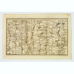
The Road from London to Barnstable, in Devonshire, commencing at Andover, in the road to the Lands End, also from Barnstable to Truro.
A highly detailed late eighteenth century road map, running left to right, commencing at Andover in Hampshire and continuing on to Barnstable in north Devonshire. The map...
Date: London, 1775
![Prospect des Plazes vor dem Rath Haus zu Boston. Vuë de la Rue et de la Maison de Ville a Boston. [together with] Prospect der König[lichen] ...](/uploads/cache/34214-250x250.jpg)
Prospect des Plazes vor dem Rath Haus zu Boston. Vuë de la Rue et de la Maison de Ville a Boston. [together with] Prospect der König[lichen] ...
Two so-called optical prints show a decorative imaginary view of the old state house, built in 1657, which was the center of government for the colony of Massachusetts an...
- $1500 / ≈ €1272
Date: Augsburg, ca. 1776
Carte de la Lithuanie Prussienne qui comprend les Palatinats de Livonie, de Witepsk, de Liscislaw, et une partie de ceux de Polock et de Minsk cédés par la Pologne à la Russie. Dressée sur l'Exemplaire des Héritiers Homann 1775.
Detailed map of the areas along the river Dnieper and Duna. Santini gives credit to Homann Heirs in the cartouche.The map was prepared by the Venetian cartographer and pu...
Date: Venice, 1776
![[Upper sheet map only] The Provinces New York, and New Jersey with part of Pensilvania and the Province of Quebec.](/uploads/cache/25624-250x250.jpg)
[Upper sheet map only] The Provinces New York, and New Jersey with part of Pensilvania and the Province of Quebec.
Rare separately issued map, unfortunately only the upper part of the map. It is a variant of this important colonial map. The upper sheet showing the upper course of the ...
- $750 / ≈ €636
Date: Frankfurt, 1777
![Schat-Kamer ofte konst der stuurlieden, behelzende een duidelyke onderwyzinge in de navigatie. . . [bound with] Tafelen bevattende De Sinussum, tangenten en Secanten. . . [bound with] Geographische Tadfel...](/uploads/cache/33112-250x250.jpg)
Schat-Kamer ofte konst der stuurlieden, behelzende een duidelyke onderwyzinge in de navigatie. . . [bound with] Tafelen bevattende De Sinussum, tangenten en Secanten. . . [bound with] Geographische Tadfel...
Schat-Kamer ofte konst der stuurlieden, behelzende een duidelyke onderwyzinge in de navigatie. . . [bound with] Tafelen bevattende De Sinussum, tangenten en Secanten. . ....
Date: Amsterdam, J. v. Keulen en Zoonen, 1777

(Title page) Recueil d'ornemen dédié a Monsieur en l'année 1777.
Beautiful title page. In the center a medallion with the portrait of Louis Stanislas Xavier de Bourbon. He was King of France and of Navarre from 1814 to 1824, omitting t...
Date: Aix en Provence, 1777

A Map of the most Inhabited part of New England containing the Provinces of Massachusetts Bay and New Hampshire, with the Colonies of Connecticut and Rhode Island.
A copper engraving in four sheets, published in Georges Louis Le Rouge, in his "Atlas Ameriqua in Septentrional Contenant les details des differentes provinces, de c...
Date: Paris, 1777
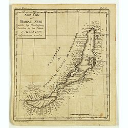
Neue Carte des Baikal Sees welche bey Umschiffung desselben in den Iahren 1773 und 1773 aufgenommen worden.
Rare engraved map by Johanna Dorothea Sysang, showing Lake Baikal. Johanna Dorothea Sysang (1729 - 1791) was a copper engraver from and was a daughter of Johann Christoph...
Date: 1777
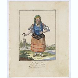
Une Kabardinienne.
Uncommon copper engraved costume plate from the French translation of Johann Gottlieb Georgi "Beschreibung aller Nationen des Russischen Reichs" (1776), the wor...
Date: St. Petersbourg, C.G. Müller, 1776-1777

Femme Barabinzoise.
Uncommon copper engraved costume plate from the French translation of Johann Gottlieb Georgi "Beschreibung aller Nationen des Russischen Reichs" (1776), the wor...
Date: St. Petersbourg, C.G. Müller, 1776-1777

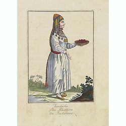
Fille Barabinzoise.
Uncommon copper engraved costume plate from the French translation of Johann Gottlieb Georgi "Beschreibung aller Nationen des Russischen Reichs" (1776), the wor...
Date: St. Petersbourg, C.G. Müller, 1776-1777
Une Baskirienne.
Uncommon copper engraved costume plate from the French translation of Johann Gottlieb Georgi "Beschreibung aller Nationen des Russischen Reichs" (1776), the wor...
Date: St. Petersbourg, C.G. Müller, 1776-1777
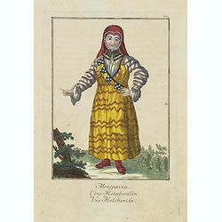
Une Metcherèke.
Uncommon copper engraved costume plate from the French translation of Johann Gottlieb Georgi "Beschreibung aller Nationen des russischen Reichs" (1776), the wor...
Date: St. Petersbourg, C.G. Müller, 1776-1777

Carte nouvelle de l'Amérique angloise contenant tout ce que les Anglois possèdent. . . avec la Floride / gravée. . . par Maththias Albert Lotter. . .
As mentioned in the title piece, the map includes the area at that time in the possession of the English, i.e. Canada, New Large, beautiful and detailed map of the Easter...
Date: Augsburg, 1777
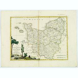
Li Governi di Normandia del Maine e Perche. . .
An attractive map that encompasses all of Normandie with the semi-autonomous English Channel Islands islands of Alderney, Jersey & Guernsey, Maine in the French provi...
Date: Venice, 1777
![[ Text / title page Charts of the coasts and harbours of New England . . .]](/uploads/cache/44832-250x250.jpg)
[ Text / title page Charts of the coasts and harbours of New England . . .]
Letterpress text page, taken from the "Atlantic Neptune".The Atlantic Neptune is universally recognised as one of the most magnificent atlases ever made.Example...
Date: London, 1777

Pio Septimo Pont Max. Bonarum artium restitutori ac vindici D.D.D.
Engraving with etching reproducing the upper half of the north wall of the Stanza dell'Incendio in the Vatican. Lettered with artists' names and dedication to Pope Pius V...
Date: Rome, 1772-1777
![Carte nouvelle de l'Amérique angloise contenant tout ce que les Anglois possèdent […] avec la Floride / gravée[…] par Maththias Albert Lotter. . .](/uploads/cache/47847-250x250.jpg)
Carte nouvelle de l'Amérique angloise contenant tout ce que les Anglois possèdent […] avec la Floride / gravée[…] par Maththias Albert Lotter. . .
A large, beautiful and detailed map of the Eastern Seaboard, from Northern Florida St. Augustine) to Newfoundland, and the St. Lawrence Gulf, including numerous Indian tr...
Date: Augsburg, 1777
![[Lower half] Amerique Septentrionale avec les Routes, Distances en miles, Limites et Etablissements François et Anglois Par le Docteur Mitchel Traduit de 'Anglois..](/uploads/cache/49378-250x250.jpg)
[Lower half] Amerique Septentrionale avec les Routes, Distances en miles, Limites et Etablissements François et Anglois Par le Docteur Mitchel Traduit de 'Anglois..
This is the important 1777 Georges Le Rouge French edition of the seminal John Mitchell map of the eastern part of North America. The Mitchell map is considered the singl...
Date: Paris, 1777

Ilse Paese de' Selvaggi.. Lago Superiore. (Florida and the Bahamas)
Antonio Zatta published an Italian version of the John Mitchell map in twelve sheet. This sheet depicts Lake Superior in the Bellin version, as it appeared on the Mitchel...
Date: Venice, 1778
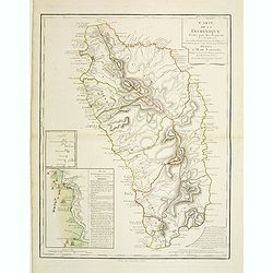
Carte de la Dominique Prise par les Francois le 7 Septembre 1778. Avec le Plan du Debarquement et de l'Attaque des Forts et Batteries par les Troupes et Les Fregates de sa Majeste
A rare map of St. Dominica, with insets of Charlotteville with its attack by the French on 7 September 1778 on the British. Also small inset map of the Caribbean islands ...
- $500 / ≈ €424
Date: Paris, 1778
Parte Orientale della Florida, della Giorgia, e Carolina. . .
Attractive map covering the coast from S.Augustine till Long Bay, including Jacksonville, Savannah. From Zatta's Atlante Novissimo.
- $350 / ≈ €297
Date: Venice, 1778

