Browse Listings

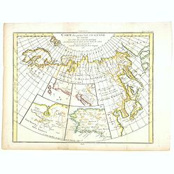
Etats du Grand-Seigneur en Asie, empire de Perse, pays des Usbecs, Arabie et Egypte.
Detailed map of the region bounded by the Black Sea, Georgia, the Caspian, Uzbekistan, The Indian Ocean, Saudi Arabia (here called \"Arabie Heureuse\"), Egypt a...
Date: Venise, 1778

Carte Réduite Des Côtes Orientales De L' Amérique Septentrionale Contenant Partie du Nouveau Jersey.. Virginie.. Georgie..
Uncommon chart that extends from Delaware Bay and Philadelphia south through much of Georgia to Island Amelia and St. Johns River. Fleur-de-lis and rhumb lines fill the s...
Date: Paris, 1778
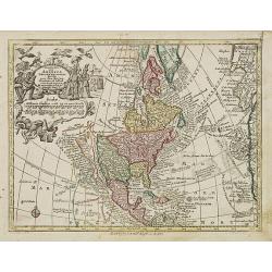
Nov' Orbis Sive America Septentrionalis. . .
Miniature map of North America, a reduction of the appropriate part of Seutter's folio map of the Americas, drawn by Albert Seutter. An unusual looking map, its projectio...
Date: Augsburg, J.M.Will, 1778
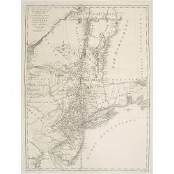
Carte des troubles De L'Amerique Levée par Ordre du Chevalier Tryon. . . New-York.. Jersey..
Revolutionary War mapA French edition of this uncommon Revolutionary War map describes the region from Salem, Massachusetts, to Buzzard's Bay, south to the Delaware River...
- $1500 / ≈ €1272
Date: Paris, 1778
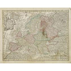
Europa religionis Christiania, morum et pacis. . .
Miniature map of Europe, a reduction of Seutter''s folio map.From Atlas Minor, here published by Johann Martin Will, with his address in bottom center of the map.The cart...
- $200 / ≈ €170
Date: Augsburg, J.M.Will, 1778

Africa juxta navigationes et observat recentissimas. . .
Miniature map of Africa, a reduction of the Seutter folio map based on Homann''s cartography of 1715. Very detailed - much of it fictitious. The Nile is shown not only or...
Date: Augsburg, J.M.Will, 1778
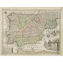
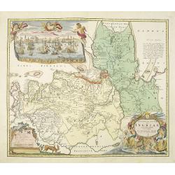
Novillinta et accura tilsnia Regnorum Hispaniae et Portugalliae. . .
Miniature map of Spain and Portugal, a reduction of the Seutter''s folio map.From Atlas Minor, here published by Johann Martin Will, with his address in bottom center of ...
Date: Augsburg, J.M.Will, 1778
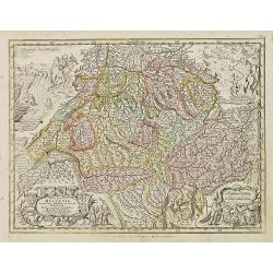
Nova Totius Helvetiae cum suis subditis ac sociis tab. Geogr. . .
Miniature map of Switzerland. Engraved by Tobias Conrad Lotter. Helvetia is the Roman name for an ancient region of central Europe occupying a plateau between the Alps an...
- $200 / ≈ €170
Date: Augsburg, J.M.Will, 1778
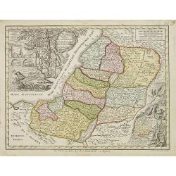
Terra Sancta vocata quae olim XII tribus . . .
Miniature map of the Holy Land, among the 12 Tribes and divided into 6 provinces. In the upper left near the title cartouche Pharaoh''s daughter discovers Moses in the Ri...
- $300 / ≈ €254
Date: Augsburg, J.M.Will, 1778
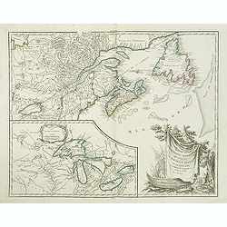
Partie de l'Amerique septent? Qui comprend la nouvelle France. . .
A fine copy of this map of New Foundland, Nova Scotia and the course of the St.Lawrence to Lake Ontario in a forth state.An inset shows Bellini's famous and important map...
Date: Paris, 1755-1778
La Baja D'Hudson Terra di Labrador e Groenlandia.
Decorative map of Nova Scotia, Hudson Bay and part of Greenland. With many names of villages, as well engraved mountains and rivers are shown.Published in Zatta's "A...
- $300 / ≈ €254
Date: Venice, 1778
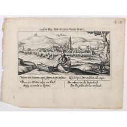
Sontra.
A panoramic view of the city Sontra in Hessen . With motto "ein klug Kind das sein Mutter kennt". On the foreground, a woman with two children and a crypt. With...
- $50 / ≈ €42
Date: Frankfurt, 1623-1778

St. Cruis ( in eastern Poland.)
A very nice view of Kloster Heiligkreuz (Swiety Krzyz), in eastern Poland. In the foreground, a man climbing up a column is depicted. With a verse in two languages undern...
- $50 / ≈ €42
Date: Frankfurt, 1623-1778

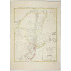
Mappa Geographica provinciae Nova Ebboraci ab Anglis NEW-YORK dictae. . .
During the Revolution, this map afforded British commanders an excellent overview of areas that would be crucial in the early years of the war, particularly the Hudson Va...
Date: Nuremberg, 1778
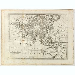
A new and accurate map of Asia, Drawn from the most approved modern maps & charts / by Thos. Bowen.
The map is of interest for the use of Sea of Korea for the sea between Korea and Japan.Detailed map of Asia from Saudi Arabia, Persia, Russia, India, China, Japan to Sout...
Date: London, J.Cooke, 1777-1778
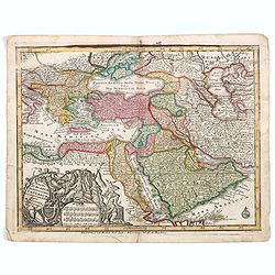
Magni Turcarum dominatoris Imperium . . .
Uncommon version of this small map of the Ottoman Empire extending from the Balkans and the north African coast through Arabia the Black Sea. Decorated with a small compa...
Date: Augsburg, J.M.Will, 1778
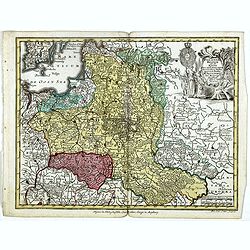
Polonia regnum ut et magni Ducat Lithuania. . .
Miniature map of Poland, a reduction of the appropriate part of Seutter's folio map. Engraved by Tobias Conrad Lotter.From Atlas Minor, here published by Johann Martin Wi...
- $450 / ≈ €382
Date: Augsburg, J.M.Will, 1778
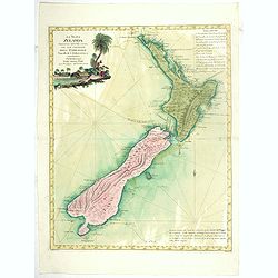
La Nuova Zelanda tracorsa nel 1769 e 1770 dal Cook commandante dell' Endeavour Vascello di S.M.Britannica.
Antonio Zatta’s map of New Zealand is not only one of the first to show the results of Cook’s voyages, but is also one of the most attractive of the islands. Consider...
Date: Venise, 1778
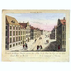
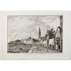
Vue de la Rue du Roi, vers la Porte de la Campagne a Boston.
A vue d'optique of the city of Boston. A view of a typical Bostonian street, with buildings opening directly onto the throughway, groups of people, gentlemen, workers and...
Date: Augsburg, 1778
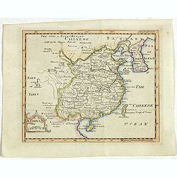
China.
A nice mid-eighteenth-century map of China, extending from the island of Hainan in the south, to the Kobi Desert in the north, from Lake Puka in Tibet in the west to Kore...
- $150 / ≈ €127
Date: Edinburgh, 1778
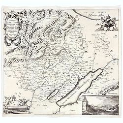
Incliti Cantonis Friburgensis Tabula, autore Francisco Petro VON DER WEID. Senatore et Commissario generale Friburgi. anno Domini 1668.
Very rare 2-sheet map and the first map of the canton Fribourg (Freiburg) in a scale of Scale 1:120.000. South to the top.The area shown on the map encompasses the whole ...
- $7500 / ≈ €6359
Date: Fribourg, 1668 but ca. 1778
Mappa Geographica provinciae Nova.. NEW-YORK..
This map afforded British commanders during the Revolution an excellent overview of areas that would be crucial in the early years of the war, in particular the Hudson Va...
- $1500 / ≈ €1272
Date: Nuremburg, 1778

Mappa geographica Provinciæ Nova Eboraci ab Anglis New-York . . .
Lower part of the two sheets map of Homann Heirs' edition of Sauthier's celebrated map of New York and New Jersey, made during the Revolutionary War. Appears in Homann's ...
Date: Nuremburg, 1778
![[Title page] Atlas général et élémentaire. . .](/uploads/cache/47732-250x250.jpg)
[Title page] Atlas général et élémentaire. . .
Decorative allegorical frontispiece page from "Atlas général et élémentaire", published by Louis Charles Desnos in 1778, with five text pages. Engraved by ...
- $200 / ≈ €170
Date: Paris, 1778
![The country Coromandel from the Coleroon to Cape Comorin. . . [with] The carnatic from the Pennar to the Coleroon. .](/uploads/cache/48363-250x250.jpg)
The country Coromandel from the Coleroon to Cape Comorin. . . [with] The carnatic from the Pennar to the Coleroon. .
Coromandel from the Coleroon to Cape Comorin. Elegant map in two sheets compiled for the East-India Company. In lower right margin : Writing by W. Harrison.
- $300 / ≈ €254
Date: London, 1778
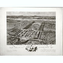
Plan perspective de l'École royale militaire.
A decorative bird's eye view of the complex of the French military school in Paris, 1777, showing all grounds and buildings of the 'Ecole Royale Militaire', drawn 'd'apr�...
- $250 / ≈ €212
Date: Paris, 1778
Ecclesae R.R.M.M. Ord. Servorum (vulgo Cappuccine) super ripam dictam Fondamente Nuove Prospectus litora versus.
Ecclesae [sic] R.R.M.M. Ord. Servorum (vulgo Cappuccine) super ripam dictam Fondamente Nuove Prospectus litora versus". Apud Ludovicum Furlanetto supra Pontem vulgo ...
Date: Venice, c. 1778
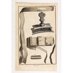
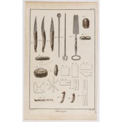
Chirurgie, plate XVIII
Showing bondage from the medical section of Diderot's Encyclopaedia. Engraved by Bernard after a design of Goussier. Very important work as it is giving an inventory of t...
- $100 / ≈ €85
Date: Paris 1779
Chirurgie, plate II.
Showing medical instruments and bondage from the medical section of Diderot's Encyclopaedia. Engraved by Bernard after a design of Goussier. Very important work as it is ...
- $80 / ≈ €68
Date: Paris 1779

Chirurgie, plate XXXII
Showing medical bondage from the medical section of Diderot's Encyclopaedia. Engraved by Bernard after a design of Goussier. Very important work as it is giving an invent...
- $80 / ≈ €68
Date: Paris 1779
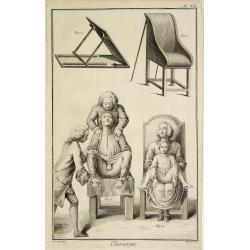
Chirurgie, plate XII
Showing medical chair and physician at work from the medical section of Diderot's Encyclopaedia. Engraved by Bernard after a design of Goussier. Very important work as it...
Date: Paris 1779
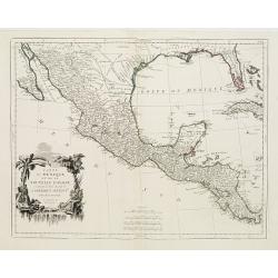
Carte du Mexique et de la Nouvelle Espagne..
Santini's version of D'Anville's important map shows the south-eastern part of the United States, Mexico and the Gulf of Mexico. Tecas is named as Nouv'le Leon. La Salle'...
Date: Venice 1779

Carte des parties Nord et est de l'Asie..
Five maps on one sheet show the Northern Russian territories in Europe and Asia, including the western coastline from Siberia, Japan, and Korea with the island of "Q...
Date: Paris, 1779
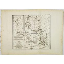
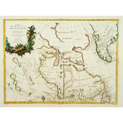
Carte de la Californie et des Pays Nord-Ouest. . . 4de Carte.
Diderot's famous 2 on 1 map shows the two early mappings of the west coast of North America, the first after Visscher, the second after Plancius' World map. Both show the...
- $200 / ≈ €170
Date: Paris, 1779
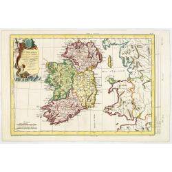
L'Irlande. . .
Map of Ireland, prepared by M. Philippe, embellished with a decorative title cartouche. Engraved by Vallet.
Date: Paris, 1779
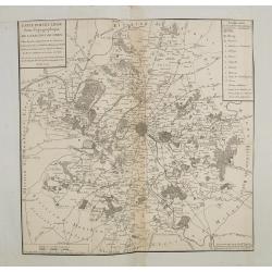
Carte particuliere semi-topographique de l'election de Paris. . .
Very decorative maps. Maps of the Parisian region. Map including Luzarches, Orgeval, Arpajon, Bussy saint georges.
- $300 / ≈ €254
Date: Paris 1779
![[Title page] Recueil de tous les Costumes.](/uploads/cache/06437-250x250.jpg)
[Title page] Recueil de tous les Costumes.
Uncommon and decorative title page of a man holding a curtain with title and a woman reading a book. With a dedication to Mr. Bignon, who was librarian of the King of Fra...
- $200 / ≈ €170
Date: Paris, 1779
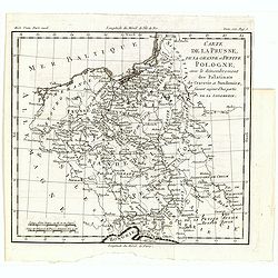
Carte de la Prusse, de la Grande et Petite Pologne, avec le démembrement des Palatinats de Cracovie et Sandomirz, faisant aujour d'hui partie de la Lodomerie.
A map of the Polish territories by Louis Brion de la Tour, from the work "Histoire universelle depuis le commencement du monde jusqu a present" published in Par...
Date: Paris, 1779
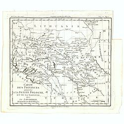
Carte des provinces annexées à la petite Pologne, et de la Gallicie, avec la Lodomerie, démembrées de la Pologne.
A map of the southern provinces of Poland by Louis Brion de la Tour, from the work "Histoire universelle depuis le commencement du monde jusqu a present" publis...
Date: Paris, 1779
Carte des parties Nord et Est de L'Asie. . .
Five maps on one sheet, showing the Northern Russian territories in Europe and Asia, including the western coastline from Siberia, with Japan and Korea with the island of...
- $100 / ≈ €85
Date: Paris, 1779
![[Title page] Atlante Novissimo, Tomo I . . .](/uploads/cache/43898-250x250.jpg)
[Title page] Atlante Novissimo, Tomo I . . .
Decorative Venitian frontispiece from Antonio Zatta's "Atlante Novissimo tomo I".
Date: Venice, 1779

Chirurgie, plate XIV.
Showing medical bondage from the medical section of Diderot's Encyclopedia. Engraved by Bernard after a design of Goussier. Very important work as it is giving an invento...
- $50 / ≈ €42
Date: Paris, 1779
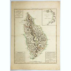
L'Isle de la Dominique par M.J.M.Anglois. . .
A handsome map of the Caribbean island of Dominica. There are "Observations" at lower left, and "Suite des observations" at lower right, both providin...
Date: Paris, 1779
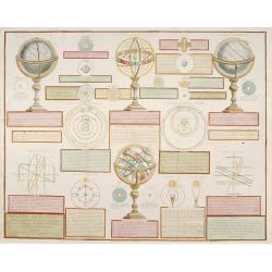
Analytique des différentes positions de la Sphère, des différens systemes, des révolutions et des distances des Planètes, &c
Containing "Globe Celeste", "Sphere de Copernic", "Globe Terrestre", "Systeme de Ptolomee" ; including diagrams of the solar syste...
Date: Paris, 1780
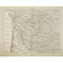
Carte du Bourdelois du Perigord et des provinces voisines..
Map covering the area from La Rochelle till the surrounding country of Bordeaux to the south and till Limoges and Cahors to the east.
- $120 / ≈ €102
Date: Paris, c. 1780
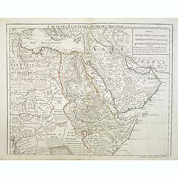
Carte de l'Egypte de la Nubie de l'Abissinie..
Map of east Africa showing South Arabia.
- $200 / ≈ €170
Date: Paris, 1780
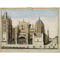
Vüe de L'Eglise Cathedrale de Tolede.
A so-optical print of a church in Toledo, Spain, prepared for use in a light-box or an amusing light-show. This richly hand colored print is much perforated, windows are ...
Date: Italy ca 1780
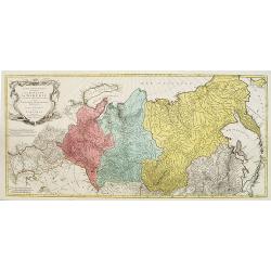
Carte géographique contenant le royaume de Sibérie . . .
Scarce and highly detailed map of Siberia subdivided into three provinces, namely Tobolsk, Jenissejesk, Irkutsk, and outer parts of the Tartary.In upper right corner inse...
Date: Augsburg, c. 1770-1780

Gezicht van het Admiraliteits-Magazyn en Scheeps Timmerwerf.
Formerly the V.O.C. warehouse and arsenal for the Admiralty of Amsterdam, now-a-days the Scheepvaartmuseum (Maritime Museum). Taken from the "Atlas of Amsterdam"...
Date: Amsterdam, 1780

A Perspective View of the Admiralty Office, Dock-Yard, Storehouses &c. at Amsterdam.
Decorative engraving giving good detail of the intense activity in the Amsterdam dockyards.Engraved for BANKES's New System of Geography
Date: Amsterdam, 1780

Carte d'une Partie des Cotes de la Floride et de la Louisiane, Contenant le Cours du Mississipi...
A well engraved and highly detailed chart of part of the Gulf Coast, dated 1778 that was issued in Neptune americo-septentrionale. The chart covers the area between St. J...
Date: Paris, 1778-1780
Prospect des Escurials von vornen gegen Madrid / L'entrée de l'Escurial, en perspective.
A so-called optical print of the the entrance to the Escurial at the foot of the Sierra Guadarrama in Spain. Bilingual title in German and French. Engraved by Leizel.
Date: Augsburg, 1780
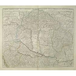
Carte Particuliere de la Hongrie de la Transilvanie de la Croatie et de la Sclavonie Dressée sur les Onservations de Mr. Le Comte Marsilli. . . Par G. Delisle.
Map of Hungary and Slovakia and adjacent parts of Croatia, Serbia and Romania (Transylvania). Prepared by Marsilli, published by Dezauche.
Date: Paris, ca. 1780

Vue du Magazin de la Compagnie des Indes Orientales. . .
So-called optical print of the formerly the V.O.C. warehouse and arsenal for the Admiralty of Amsterdam, now-a-days the Scheepvaartmuseum (Maritime Museum).In the eightee...
Date: France, 1780
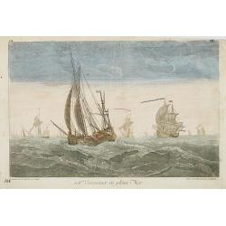
108e. Vaisseaux en pleine Mer.
Optical print of ships in the open sea, by Daumont, who was a well-known publisher of optical prints, established in Paris.In the eighteenth and nineteenth centuries, the...
- $200 / ≈ €170
Date: Paris, 1780
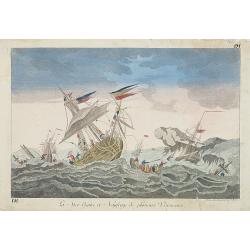
La Mer Agitée et Naufrage de plusietrs Vassseaux.
So-called optical print illustrating a dramatic rough sea with the wrecking of 3 ships.A so-called optical print by Daumont. In the eighteenth and nineteenth centuries, m...
- $200 / ≈ €170
Date: Paris, 1780

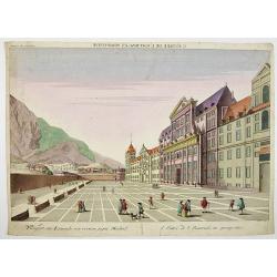
Madrid.
Extremely rare town-view of Madrid. Engraved by Francesco Ambrosi.With a second title in lower part "Madrid Ciudad Capital Del Reyno D'Espana y real corte de los rey...
Date: Bassano del Grappa, c.1780

Gezicht van het Oost-Indisch-Huys, op de binnen plaats te zien, tot Amsterdam.
Taken from the "Atlas of Amsterdam". Showing the inner square of the East Indian House of the V.O.C. in Amsterdam.A place for meeting, trading and storage of sp...
Date: Amsterdam, 1780
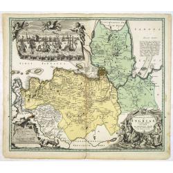
Ingermanlandiae seu Ingriae novissima tabula luci tradita. . .
Detailed map centered on Saint Petersburg. With imposing title cartouche and panoramic view of Saint Petersburg. The map was drawn shortly after the conclusion of the Gre...
Date: Nurenberg, 1780
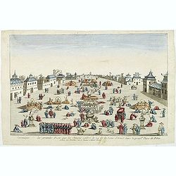
Ceremonie de la grande Feste que les Chinois celebre le 24 de la Lune d'Aoust dans la principale Place de Pekin.
So-called optical print illustrating the festivities on the 24th of August in Beijing.Mondhare was a well-known publisher of optical prints, established in Paris, at rue ...
Date: Paris, c.1780
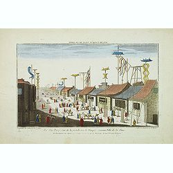
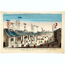
Vue perspective de la grande Rue de Nanquin ancienne Ville de la Chine.
So-called optical print of a street in Nanking. The wide boulevard is lined with merchants displaying their wares with colorful flags and signs. The street is filled with...
Date: Paris, c.1780

La Pologne Dressée sur ce qu'en ot donné Starovolsk, Beauplan, Hartnoch. . .
Large map of Poland, Lithuania, Belarus and part of Ukraine. The map is filled with detail and decorated with a title cartouche flanked by mythological figures.According ...
Date: Paris, 1773 - 1780
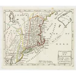
Carte de la Nouvelle Angleterre, Nouvelle York, Nouvelle Jersey, et Pensilvanie.
Highly detailed regional map of the Northeastern US, featuring numerous place names, Forts, Native American tribes, rivers,coastal banks, and other details. This is a Fre...
- $250 / ≈ €212
Date: Paris, 1780
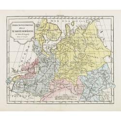
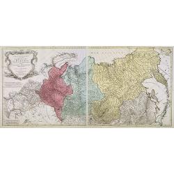
Partie Septentrionale de la Russie Européenne . . .
Detailed map of European part of Russia, including Finland and Lapland.
Date: Paris, 1780
Carte géographique contenant le Royaume de Siberie . . .
Very rare and highly detailed map of Siberia subdivided in three provinces, namely Tobolsk, Jenissejesk, Irkutsk, and outer parts of the Tartary. In upper right corner in...
- $800 / ≈ €678
Date: Augsburg, 1770- 1780

Vue perspective de l'interieur de la Salle du spectacle de Veronne en Italie.
Showing the Opera of Verona. Optical print published Mondhare, who was a well-known publisher of optical prints, established in rue St. Jacques in Paris. In the eighteent...
Date: Paris, ca. 1780
![Fille Jakoute par derrière [together with] Fille Jakoute par devant.](/uploads/cache/32984-250x250.jpg)
Fille Jakoute par derrière [together with] Fille Jakoute par devant.
Uncommon copper-engraved costume plate from Johann Gottlieb Georgi "Beschreibung aller Nationen des russischen Reichs" (1776), the work stands out for the hand-...
- $75 / ≈ €64
Date: St. Petersbourg, C.G. Müller, 1776-1780
![Fille Jakoute par derrière [together with] Fille Jakoute par devant.](/uploads/cache/32985-250x250.jpg)
Fille Jakoute par derrière [together with] Fille Jakoute par devant.
Uncommon copper-engraved costume plate from Johann Gottlieb Georgi "Beschreibung aller Nationen des russischen Reichs" (1776), the work stands out for the hand-...
- $75 / ≈ €64
Date: St. Petersbourg, C.G. Müller, 1776-1780
![Un Jacout en habit de chasse par devant [together with] Un Jakout en habit de chasse par derriére.](/uploads/cache/32986-250x250.jpg)
Un Jacout en habit de chasse par devant [together with] Un Jakout en habit de chasse par derriére.
Uncommon copper-engraved costume plate from Johann Gottlieb Georgi "Beschreibung aller Nationen des russischen Reichs" (1776), the work stands out for the hand-...
- $75 / ≈ €64
Date: St. Petersbourg, C.G. Müller, 1776-1780
![Fille tatare à Kousnetsk par devant. [together with] Fille tatare Kousnetsk par derriere.](/uploads/cache/32988-250x250.jpg)
Fille tatare à Kousnetsk par devant. [together with] Fille tatare Kousnetsk par derriere.
Uncommon copper-engraved costume plate from Johann Gottlieb Georgi "Beschreibung aller Nationen des russischen Reichs" (1776), the work stands out for the hand-...
- $75 / ≈ €64
Date: St. Petersbourg, C.G. Müller, 1776-1780
![Femme tatare à Kousnetsk par devant. [together with] Femme tatare à Kousnetsk par derriere.](/uploads/cache/32990-250x250.jpg)
Femme tatare à Kousnetsk par devant. [together with] Femme tatare à Kousnetsk par derriere.
Uncommon copper-engraved costume plate from Johann Gottlieb Georgi "Beschreibung aller Nationen des russischen Reichs" (1776), the work stands out for the hand-...
- $75 / ≈ €64
Date: St. Petersbourg, C.G. Müller, 1776-1780
![Une Kirguisiene par devant. [together with] Une Kirguisienne par derriere.](/uploads/cache/32991-250x250.jpg)
Une Kirguisiene par devant. [together with] Une Kirguisienne par derriere.
Uncommon copper-engraved costume plate showing two natives of Kyrgyzstan, a Central Asian country along the Silk Road, the ancient trade route between China and the Medit...
Date: St. Petersbourg, C.G. Müller, 1776-1780
Ingermanlandiae seu Ingriae. . .
Detailed map centered on St.Petersburg. With imposing title cartouche and panoramic town-view of St.Petersburg. The map was drawn shortly after the conclusion of the Grea...
- $750 / ≈ €636
Date: Nurenberg, 1780
Vue perspective de la grande Rue de Nanquin ancienne Ville de la Chine.
So-called optical print of a street in Nanking. The wide boulevard is lined with merchants displaying their wares with colorful flags and signs. The street is filled with...
Date: Paris, c.1780

Kirgise à cheval.
Uncommon copper-engraved costume plate from Johann Gottlieb Georgi "Beschreibung aller Nationen des russischen Reichs" (1776), the work stands out for the hand-...
- $50 / ≈ €42
Date: St. Petersbourg, C.G. Müller, 1776-1780

Femme tatare de Katchin.
Uncommon copper-engraved costume plate from Johann Gottlieb Georgi "Beschreibung aller Nationen des russischen Reichs" (1776), the work stands out for the hand-...
- $50 / ≈ €42
Date: St. Petersbourg, C.G. Müller, 1776-1780
![Une Chamane ou devineresse de Krasnojarsk par derrière.[together with] Une Chamane ou devineresse de Krasnojarsk.](/uploads/cache/33007-250x250.jpg)
Une Chamane ou devineresse de Krasnojarsk par derrière.[together with] Une Chamane ou devineresse de Krasnojarsk.
Uncommon copper engraved costume plate from Johann Gottlieb Georgi "Beschreibung aller Nationen des russischen Reichs" (1776), the work stands out for the hand-...
- $100 / ≈ €85
Date: St. Petersbourg, C.G. Müller, 1776-1780

Le globe terrestre representé en deux plans-hemispheres, Dressé sur la Projection de Mr. De la Hyre...
“This splendid GlobeTerrestre originally published by J.B. Nolin is one of the finest large-scale world maps to be produced and is a fitting bridge between the geograph...
Date: Paris, c. 1780
Tempum S.Joannis in Laterano Romae. . .
A so-called optical print. In the eighteenth and nineteenth centuries there were many popular specialty establishments in Paris, Augsburg and London which produced optica...
- $150 / ≈ €127
Date: Italy, ca.1780
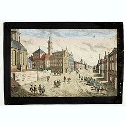
Prospect der Strasse gegen der Kirche der Recolecten in der obern Stadt zu Quebec. Vuë de la Rue des Recolets dans la haute Ville de Quebec.
A so-called optical print showing a decorative imaginary town view of Québec, with a street view with soldiers marching and pedestrians, an idealized view depicting Qué...
- $450 / ≈ €382
Date: Augsburg, ca. 1780

