Browse Listings
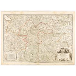
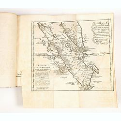
Le Comté de Tirol, les Evèchés de Trente et de Brixen..
Detailed map of Austria showing territories of Tyrol, Bavaria, Brixen. Engraved by Cordier.
Date: Paris, 1761
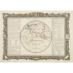
Division Générale et Naturelle de la Terre, Suivant les Anciens.
Decorative chart showing the world as it was known by the ancients.Left and right a box with geographical information about Europe, Asia and Africa.Prepared by Buy de Mor...
Date: Paris, 1762
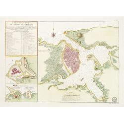
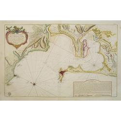
Carte Hydrographique de la Baye de la Havane.. N° 69.
A well-engraved and highly detailed chart of the walled city of Havana and its harbor features inset plans of three forts (La Punta, El Morro, and La Real Fuerza) as well...
Date: Paris, 1762
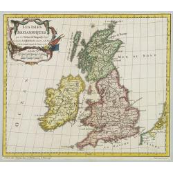
Les Isles Britanniques..
A first state (of 2) dated 1762. Fine map of the British Isles, engraved by E.Dussy. Fine title cartouche upper left engraved by Arrivet. From his Nouvel Atlas Portatif .
Date: Paris, 1762
Carte Hydrographique De La Baye De Cadix. . .
Beautiful chart of the Bay of Cadiz, from Rota to Cadiz, with dramatic coastal topography, soundings, anchorages, forts, loxodromic lines, compass rose and large decorati...
Date: Paris, 1762
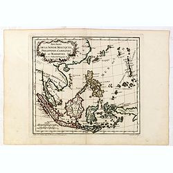
Les Isles de la Sonde, Moluques, Philippines, Carolines, et Marlannes.
Nice detailed map of southeast Asia, showing the Malay Peninsula, Sumatra, Java and the island of Borneo. Engraved by E. Dussy and the title cartouche by Arrivet. From hi...
- $275 / ≈ €233
Date: Paris, ca. 1762
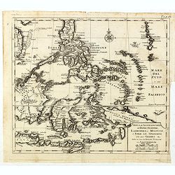
Nuova et Accurata Carta dell' Isole Filippine, Ladrones, a Moluccos o Isole della Speziarie come anco Celebes &c.
The map has been prepared by Isaac Tirion for his Nieuwe en beknopte Handatlas (New and concise hand-atlas) of which Albrizzi made an imitation and used in the Italian ed...
- $400 / ≈ €339
Date: Venice, 1740-1762
![[Titlepage] Atlas Homannianus Mathematico Historice delineatus.](/uploads/cache/36600-250x250.jpg)
[Titlepage] Atlas Homannianus Mathematico Historice delineatus.
Title page with In the foreground the female figures of Geography, History and Astronomy stand before a large globe, showing the Eastern Hemisphere. Above them the atlas ...
- $350 / ≈ €297
Date: Nuremberg, 1762
![[Mer Baltique]](/uploads/cache/37796-250x250.jpg)
[Mer Baltique]
Detailed map of Northern part of Poland with Danzig, from his "Atlas moderne ou collection de cartes...".map N° 15.
- $300 / ≈ €254
Date: Paris, 1762
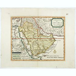
Carta nuova dell' Arabia fatta in Amsterdam per Isauc Tirion.
Detailed map of Arabia and environs, prepared by Albrizzi and published in Thomas Salmon in " Lo Stato Presente di Tutti i popoli del mondo naturale, politico e mora...
- $650 / ≈ €551
Date: Napels, Francesco Ricciardo, 1738 -1762
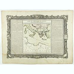
Suite de l'Histoire de Perse. Depuis l'An 3519, jusqu'à l'An 3525.
Showing eastern Europe centered on Greece, Macedonia, Persia and western Turkey. Textural information in French flanking the map. De Mornas was Geographer to Louis XVI, a...
- $60 / ≈ €51
Date: Paris, 1762
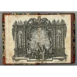
Atlas Geographicus portatilis XXIX mappis orbis habitabilis
Fine pocket atlas containing a world and celestial map, further maps of the four continents and of European countries. The map of America has a blank coastline north to C...
- $2750 / ≈ €2332
Date: Augsburg 1762
Carte de la Guyane Françoise et l'Isle de Cayenne..
A well engraved and highly detailed chart of French Guiana and the island of Cayenne. Made in 1763 by Jacques Bellin (1703-72), a prolific cartographer assigned the Minis...
Date: Paris, 1763

Nieuwe gemeten kaart van de colonie de Berbice met der zelver plantagiën en de namen der Bezitters. . .
Re-issue of his map from 1740, without the printed list of owners, with a large added contemp. hand-colored cartouche Relaas van de rebellie, ontstaan op de plantagien in...
Date: Amsterdam, ca.1763
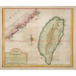
L'Isle Formose et parties des Costes de la Chine. . .
This well-known map of Taiwan was prepared by Jacques Nicolas Bellin and was based on Jesuit information. The text along the island's east coast claims: Of this coast, ...
Date: Paris, 1763
Histoire universelle depuis le commmencement du monde jusqu'a present. Tome Vingt-unieme. Portugais, Espagnols, Hollanois etc
Volume 21 of this informative publication with a description of the discoveries, conquests, and settlements by the Portuguese, Spaniards, English, and Dutch in Southeast ...
- $1200 / ≈ €1017
Date: Amsterdam, Leipzig, 1763
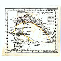
Map of Senegal with part of the coast of Africa.
Uncommon miniature map of Senegal with part of the coast of Africa, engraved by Thomas Kitching for "A New General and Universal Atlas Containing Forty five Maps by ...
- $40 / ≈ €34
Date: London, 1761-1763
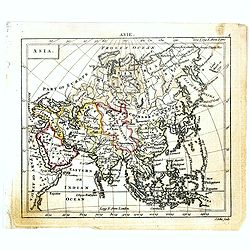
Asia.
Uncommon miniature map of Asia. The map is of interest for the use of Sea of Corea, for the sea between Korea and Japan.Engraved by J.Ellis for "A New General and Un...
- $150 / ≈ €127
Date: London, 1761-1763
![East Indies. {India]](/uploads/cache/38623-250x250.jpg)
East Indies. {India]
Uncommon miniature map of India, engraved by Thomas Kitching for "A New General and Universal Atlas Containing Forty five Maps by Andrew Dury".This miniature at...
- $100 / ≈ €85
Date: London, 1761-1763
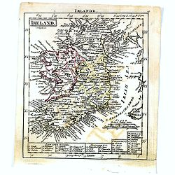
Ireland.
Uncommon miniature map of Ireland, engraved by J. Bayly for "A New General and Universal Atlas Containing Forty five Maps by Andrew Dury".This miniature atlas p...
- $50 / ≈ €42
Date: London, 1761-1763
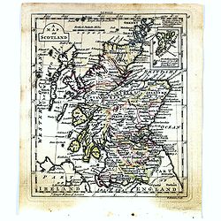
A map of Scotland.
Uncommon miniature map of Scotland, engraved by Thomas Kitching for "A New General and Universal Atlas Containing Forty five Maps by Andrew Dury".This miniature...
- $50 / ≈ €42
Date: London, 1761-1763
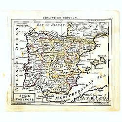
Spain and Portugal.
Uncommon miniature map of Spain and Portugal, engraved by Thomas Kitching for "A New General and Universal Atlas Containing Forty five Maps by Andrew Dury".This...
- $60 / ≈ €51
Date: London, 1761-1763
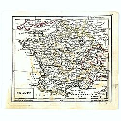
France.
Uncommon miniature map of France, engraved by J.Spilbury for "A New General and Universal Atlas Containing Forty five Maps by Andrew Dury".This miniature atlas ...
- $50 / ≈ €42
Date: London, 1761-1763
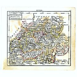
Switzerland divided into Cantonments.
Uncommon miniature map of Switzerland, engraved by Thomas Kitching for "A New General and Universal Atlas Containing Forty five Maps by Andrew Dury".This miniat...
- $30 / ≈ €25
Date: London, 1761-1763
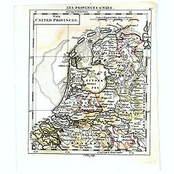
The United Provincies.
Uncommon miniature map of The Netherlands, engraved by J.Ellis for "A New General and Universal Atlas Containing Forty five Maps by Andrew Dury".This miniature ...
- $50 / ≈ €42
Date: London, 1761-1763
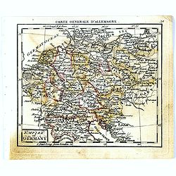
Empire of Germany.
Uncommon miniature map of Germany, Poland, the Low Countries and Eastern Europe, engraved by Thomas Kitching for "A New General and Universal Atlas Containing Forty ...
- $40 / ≈ €34
Date: London, 1761-1763
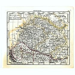
Kingdom of Hungary.
Uncommon miniature map of Hungary, engraved by Thomas Kitching for "A New General and Universal Atlas Containing Forty five Maps by Andrew Dury".This miniature ...
- $75 / ≈ €64
Date: London, 1761-1763
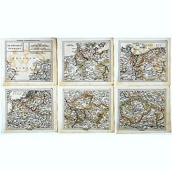
The Empire of Germany.
Uncommon miniature map in six sheets of the Empire of Germany, engraved by Thomas Kitching for "A New General and Universal Atlas Containing Forty five Maps by Andre...
- $75 / ≈ €64
Date: London, 1761-1763
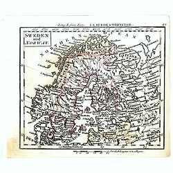
Sweden and Norway.
Uncommon miniature map of Sweden and Norway, engraved by Thomas Kitching for "A New General and Universal Atlas Containing Forty five Maps by Andrew Dury".This ...
- $75 / ≈ €64
Date: London, 1761-1763
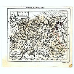
Russia in Europe.
Uncommon miniature map of Russia, engraved by Thomas Kitching for "A New General and Universal Atlas Containing Forty five Maps by Andrew Dury".This miniature a...
- $75 / ≈ €64
Date: London, 1761-1763
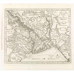
Nouvelle carte du royaume de Bengale.
Map of Bengal Kingdom prepared by J.N.Bellin.
Date: Amsterdam, Leipzig, 1763
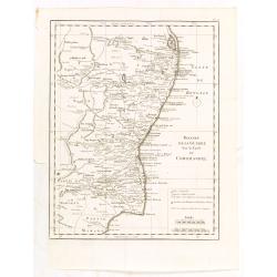
Theatre de la guerre sur la coste de Coromandel.
Map of Coromandel coast prepared by J.N.Bellin.
Date: Amsterdam, Leipzig, 1763
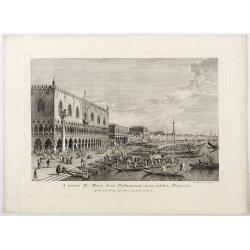
A minore D: Marci Area Dalmatarum ripam.
A minore D: Marci Area Dalmatarum ripam". View of the Riva degli Schiavoni from the east including the Palazzo Ducale in the foreground. Apud Ludovicum Furlanetto su...
Date: Venice, c. 1763
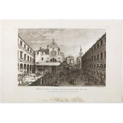
Prospectus Plateae et Ecclesiae Sancti Jacobi prope Pontem Rivi alti.
Prospectus Plateae et Ecclesiae Sancti Jacobi prope Pontem Rivi alti". The Church of San Giacomo di Rialto, at right Palazzo dei Dieci and the bridge of Rialto.From ...
Date: Venice, c. 1763
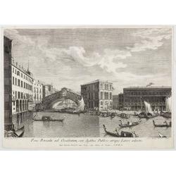
Pons Rivoalti, utriumqque Ripae, et Aedes ad Orientem.
Pons Rivoalti, utriumqque Ripae, et Aedes ad Orientem." From the series "Prospectum Urbis Venetiarum" (Views of Venice). 1st state. Published by Lodovico F...
Date: Venice, 1763
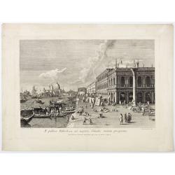
A publica Bibliotheca ad majoris Canalis initium prospectus.
A publica Bibliotheca ad majoris Canalis initium prospectus". View of the Biblioteca Nazionale Marciana, the column of San Teodoro at right, at left the Grand Canal,...
Date: Venice, 1763
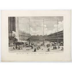
Qua late patet S. Marci area major novum Regim Palatium versus.
Qua late patet S. Marci area major novum Regim Palatium versus". View of piazza San Marco, the church of San Geminiano at the far end, figures and market stalls in t...
Date: Venice, 1763
Pons Rivoalti ad Occidentem, cum Aedibus Publicis utrique Lateri adjectis.
Pons Rivoalti ad Occidentem, cum Aedibus Publicis utrique Lateri adjectis."From the series "Prospectum Urbis Venetiarum" (Views of Venice). 1st state. Publ...
Date: Venice, 1763
Prospectus Plateae ad Divum Iacobum de Rivoalto ubi Mercatores conveniunt.
Prospectus Plateae ad Divum Iacobum de Rivoalto ubi Mercatores conveniunt. From the series "Prospectum Urbis Venetiarum" (Views of Venice). Published by Lodovic...
Date: Venice, c. 1763
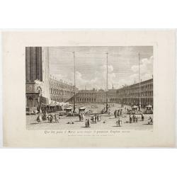
Qua late patet S. Marci area major novum Regim Palatium versus.
Qua late patet S. Marci area major novum Regim Palatium versus". View of piazza San Marco, the church of San Geminiano at the far end, figures and market stalls in t...
Date: Venice, 1763
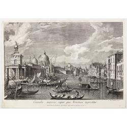
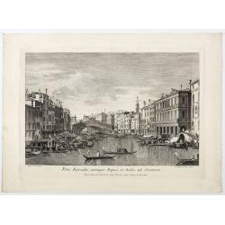
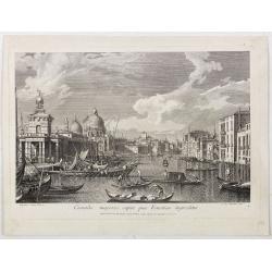
Canalis majoris caput qua Venetias ingreditur.
Canalis majoris caput qua Venetias ingreditur". A view of the Grand Canal with Santa Maria della Salute to the left after Canaletto.From the series "Prospectum ...
Date: Venice, c. 1763
![[56] I.Scio.](/uploads/cache/12828-250x250.jpg)
[56] I.Scio.
"Charming chart of the harbour of the Greek town of Chios. Showing town and harbour plan, with soundings, anchorages, rocks, shoals, fortifications and lighthouses.J...
- $80 / ≈ €68
Date: Marseille, 1764
![[59] Svr I. De Paros.](/uploads/cache/12831-250x250.jpg)
[59] Svr I. De Paros.
Charming chart of the harbour of the Greek island of Paros. Showing town and harbour plan, with soundings, anchorages, rocks, shoals, fortifications and lighthouses.Josep...
- $50 / ≈ €42
Date: Marseille, 1764
![[60] Porto de Ganea.](/uploads/cache/12832-250x250.jpg)
[60] Porto de Ganea.
Charming chart of the harbour of the Greek town of Ganea. Showing town and harbour plan, with soundings, anchorages, rocks, shoals, fortifications and lighthouses.Joseph ...
Date: Marseille, 1764
![[65] Surie.](/uploads/cache/12837-250x250.jpg)
[65] Surie.
Charming chart of the harbour of the town of St Jean d'Acre in Syria. Showing town and harbour plan, with soundings, anchorages, rocks, shoals, fortifications and lightho...
- $120 / ≈ €102
Date: Marseille, 1764
![[69] Barbarie.](/uploads/cache/12841-250x250.jpg)
[69] Barbarie.
Charming chart of the harbour of the province of Barbarie in Syria. Showing town and harbour plan, with soundings, anchorages, rocks, shoals, fortifications and lighthous...
Date: Marseille 1764
![[71] Barbarie.](/uploads/cache/12843-250x250.jpg)
[71] Barbarie.
Charming chart of the harbour of the province of Barbarie in Syria. Showing town and harbour plan, with soundings, anchorages, rocks, shoals, fortifications and lighthous...
Date: Marseille 1764
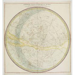
Hemisphere Celeste Antarctique ou Austral. . .
Map printed in two colors, black for the stars, red for the constellation figures. With later color addition.Uncommon large-scale celestial chart of the southern hemisphe...
- $750 / ≈ €636
Date: Paris, 1764

Plan du Port de St Augustin dans la Floride.
This chart shows a plan of the Port of St. Augustine in Florida.The only issue of this version of Bellin's map, slightly larger than the common version. Depths shown by s...
Date: Paris, 1764

Ajustement des Femmes de Valday Situé entre Petersbourg et Moscou.
Etching by Jean-Baptiste Le Prince (1734-1781), from "2me Suite de divers cris de marchands de Russie", showing typical russian customs. The sketches Le Prince ...
- $110 / ≈ €93
Date: Paris, 1764
![[Title page] Schauplatz des gegenwaertigen kriegs. . .](/uploads/cache/12307-250x250.jpg)
[Title page] Schauplatz des gegenwaertigen kriegs. . .
Title page from Schauplatz des gegenwaertigen kriegs. Very fine, typical German title page with cannons, flags, trumpets, etc.Gabriel Nikolaus Raspe (1712-1785) was activ...
- $250 / ≈ €212
Date: Nuremberg, 1757-1764
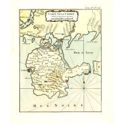
Carte de la Crimée.
Fine map of Crimea (Ukraine) here in the only issue of this version of Bellin's map, slightly larger than the common version. From Bellin's Le Petit Atlas Maritime Recuei...
Date: Paris, 1764
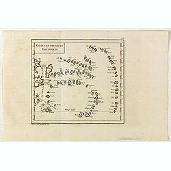
Karte von den neuen philippinen.
Small map of the southern Philippines. In: "Allgemeine Historie der Reisen zur Wasser und zu Lande: oder Sammlung aller Reisebeschreibungen.. in Englischen zusammen ...
- $200 / ≈ €170
Date: Leipzig, Arkstee und Merkus, 1764
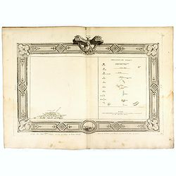
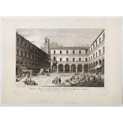
(Tableau d'explication des marques, p12)
Key sheet to a rare atlas of the province of Normandy " Atlas de la Province de Normandie dédié à Mr Thiroux de Crosne . . ." dedicated to Mr. Thiroux Crosne...
- $50 / ≈ €42
Date: Paris, 1764
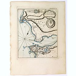
Plan de Maye a la Coste de Malabar.
From Bellin's "Le Petit Atlas Maritime", a plan of the bay of Maye, off the Malabar coast of southern India. Map relief shown pictorially. Shows settlements, po...
- $100 / ≈ €85
Date: Paris, 1764
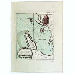
Baye Ville et Forts d'Andarajapour a la Coste de Malabar.
From Bellin's popular "La Petit Atlas Maritime", showing the bay, fort and town of Andarajapour in the Malabar region of India. The map is furnished with a comp...
- $110 / ≈ €93
Date: Paris, 1764
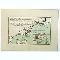
Coste de Coromandel depuis Gondagamas jusqu'a Narzapour.
This map is taken from Bellin'spopular 'Petit atlas maritime'. It shows a portion of the Indian coastline in the region of Coromandel from Montepdly through Mazulipatam o...
- $110 / ≈ €93
Date: Paris, 1764
Plan de Maye a la Coste de Malabar.
From Bellin's 'Le Petit Atlas Maritime', a plan of the bay of Maye, off the Malabar coast of southern India. Relief shown pictorially. It shows settlements, ports, and ma...
Date: Paris, 1764
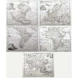
Set of four continents (Maps of North America; South America; Asia; Europe; Africa;)
Interesting set of five detailed maps of the continents. North America with large unexplored parts. Asia with unfinished coast lines and showing a "Companys Land&quo...
Date: London, 1764
![[Title page] Le Petit Atlas Maritime recueil de cartes et plans. . .](/uploads/cache/47754-250x250.jpg)
[Title page] Le Petit Atlas Maritime recueil de cartes et plans. . .
Title page of "Le Petit Atlas maritime recueil de cartes et plans des quatre parties du Monde - Cinquieme volume contenant Les costes de France" by Jacques Nic...
- $150 / ≈ €127
Date: Paris, 1764

Le Petit atlas maritime. Recueil de cartes et plans des quatre parties du monde, en cinq volumes.
FIRST EDITION. A large paper copy, in attractive original colors. Jacques Nicolas Bellin held offical status as royal hydrographer and ingéniuer géographe de la marine ...
- $45000 / ≈ €38156
Date: Paris, 1764
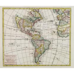
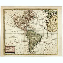
Nieuwe kaart van America.
An attractive map of both the Americas, by one of the leading mapmakers in 18th century Amsterdam. Isaak Tirion (d. 1769) was a Amsterdam publisher. His "Nieuwe en b...
- $400 / ≈ €339
Date: Amsterdam, 1765

Het stadhuis, van vooren.
The former Amsterdam Town Hall, now the Royal Palace. Copper engraving by Frans de Bakker after Reinier Vinkeles (1741-1816).From the well-known description of Amsterdam ...
Date: Amsterdam, 1765
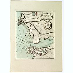
l'Arabie et l'Egypte pour la Concorde de la Géographie des different Ages.
Uncommon map of Arabian Peninsular with a title inland "Arabie Heureuse. . .".More about Mapping of Arabia [+]
Date: Paris, 1765
Nieuwe kaart van America.
An attractive map of both the Americas, by one of the leading mapmakers in 18th century Amsterdam. Isaak Tirion (d. 1769) was a Amsterdam publisher. His "Nieuwe en b...
Date: Amsterdam, 1765
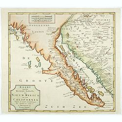
Kaart van het Westelyk Gedeelte van Nieuw Mexico en van California. . . MDCCLXV ..
A detailed map of the Baja California and Sonora, bounded on the north by the Colorado and Gila Rivers and approximately Mozatlan in the south, thus including parts of mo...
Date: Amsterdam, 1765
![Plan de Gingy, ville et forteresse d'Asie . . . [An Early Manuscript Map of Pondicherry Prior To Its Reconstruction After The Seven Years War.]](/uploads/cache/43006-250x250.jpg)
Plan de Gingy, ville et forteresse d'Asie . . . [An Early Manuscript Map of Pondicherry Prior To Its Reconstruction After The Seven Years War.]
An early manuscript map of Gingy shortly after The Seven Years War, when the French took possession of large part of India.With an extensive key to the left.Gingee Fort o...
- $1500 / ≈ €1272
Date: Paris, 1765
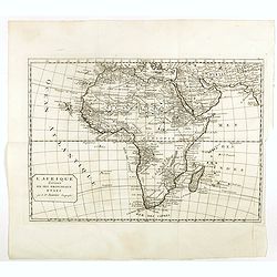
L'Afrique divisée en ses principaux etats par le Sr. Janvier Geographe.
A neatly engraved example of Jean Janvier's 1762 map of Africa. Covers the entire continent as well as the Island of Madagascar and adjacent parts of Persia and Arabia. D...
- $200 / ≈ €170
Date: Paris, ca. 1765
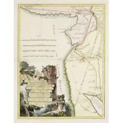
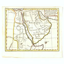
Carte de la Babylonie nommée aujourd'hui Hierac-Arab avec les noms, tant anciens que modernes et les routes des expéditions de Cyrus et de Julien l'Apostat, aussi bien que celles de Teixera, Benjamin. . .
A very fine map centered on Arabia and in top Iraq with Baghdad. With a very attractive title cartouche on the lower left-hand corner. Published by Joseph-Nicolas De l' I...
- $550 / ≈ €466
Date: Paris/ Bordeaux, 1766
Nouvelle carte géographique des postes et autres routes d'Allemagne. . .
Map showing the northern provinces in Germany and part of the Netherlands. Decorative title cartouche in the upper left corner. A so-called post road maps.
- $80 / ≈ €68
Date: Paris, 1766
Bataille du Johansberg Gagnée par son Altesse Sérénissime Monseigneur le Prince de Condé . . . Le 30 Aoust 1762 . . .
Five detailed military battle-plans showing the four stages in the siege of Johansburg and the battle plan around Grüningen published by Jean de Beaurain (1696–1771) ....
- $150 / ≈ €127
Date: Paris, 1766
![Grond-beginzels der stuurmans-konst. . . [bound with] De tafelen sinuum tangentium en secantium. [Bound with] Tafelen logarithmi der hoekmaaten, raaklynen en snylynen.](/uploads/cache/33119-250x250.jpg)
Grond-beginzels der stuurmans-konst. . . [bound with] De tafelen sinuum tangentium en secantium. [Bound with] Tafelen logarithmi der hoekmaaten, raaklynen en snylynen.
An early instruction boek for the sailor prepared by Pybo Steenstra, who the official examinator of the V.O.C.. Published by Joannes van Keulen and sons. It is clear that...
Date: Amsterdam, Joannes van Keulen, n.d. 1766

Carta Topografica dell' Isola Del Maritaggio di Monsieur le Boble per la prima volta. Tradotta dal francese in italiano.
Second Italian printing of Eustache Le Noble’s "Carte de l’isle de marriage." The book’s text offers instructions on how to reach this matrimonial island ...
Date: Cosmopoli, 1766

America settentrionale. . .
Rare map of North America drawn directly from the work of Nicholas De Fer and N. Sanson's famous map of 1650. The map is engraved by Antonius Donzel Gallus.With open Grea...
Date: Napels, 1766
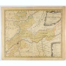
Canton Solothurn sive pagus Helvetiae Solodurensis cum confinibus recenter delineatus per Gabrielem Walserum.
A nice map of Swiss canton centered on Solothurn. Engraved by Tobias C. Lotter.
Date: Augsbourg, 1766
![[Title page] Recueil des côtes maritimes de France. . .]](/uploads/cache/47737-250x250.jpg)
[Title page] Recueil des côtes maritimes de France. . .]
Title page of Recueil des côtes maritimes de France by Louis Brion De La Tour in 1766, and published by Desnos in Paris. With a decorative shipping scene in the lower pa...
- $175 / ≈ €148
Date: Paris, 1766
![[Title page] Atlas général, civil, ecclesiastique et militaire. . .](/uploads/cache/47738-250x250.jpg)
[Title page] Atlas général, civil, ecclesiastique et militaire. . .
Title page of Recueil des côtes maritimes de France by Louis Brion De La Tour in 1766, and published by Desnos in Paris.
- $200 / ≈ €170
Date: Paris, 1766
![[Title page] Recueil des côtes maritimes de France. . .](/uploads/cache/48140-250x250.jpg)
[Title page] Recueil des côtes maritimes de France. . .
Title page of Recueil des côtes maritimes de France by Louis Brion De La Tour in 1766, and published by Desnos in Paris. With a decorative shipping scene in the lower pa...
- $150 / ≈ €127
Date: Paris, 1766
Canalis majoris caput qua Venetias ingreditur.
Bucentaurus et Nundinae Venetae in die Ascensionis". The Doge leaving for the Lido on the Bucintoro on Ascension Day.From the series of 12 views entitled Feste Ducal...
Date: Venice, c. 1766
Canalis majoris caput qua Venetias ingreditur.
Canalis majoris caput qua Venetias ingreditur". A view of the Grand Canal with Santa Maria della Salute to the left after Canaletto.From the series of 12 views entit...
Date: Venice, c. 1766

