Browse Listings
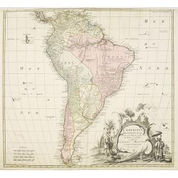
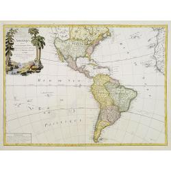
L'amerique meridionale dressee sur les memoires le plus recens. . .
Rare and decorative map of South America with good detail and interesting notations concerning the explorations of the interior. With in the lower right corner a title ca...
- $550 / ≈ €466
Date: Amsterdam, 1757
Theatrum belli Russorum Victoriis illustratum sive Nova et accurata Turcicarum et Tartaricum. . .
Uncommon and decorative map of Ukraine, showing the theatre of the Russo-Turkish War in the Ukraine in 1735-1739. The map gives detailed information of the fortifications...
Date: Nuremberg, ca. 1757
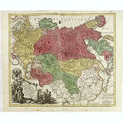
Spatiosissimum Imperium Russiae Magnae juxta recentissimas Observationes Mappa Geographica . . .
This is a decorative map of greater Russia, extending from Livonia in the west to Kamchatka, China, Tibet, Taiwan, Korea, and part of Japan in the east. To the south, it ...
- $1300 / ≈ €1101
Date: Augsburg, 1757
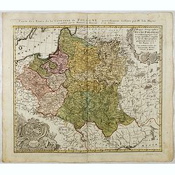
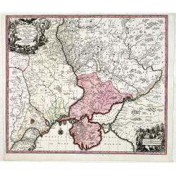
Mappa Geographica Regni Poloniae ex novissimis quotquot sunt mappis specialibus composita et al L.L. Stereographicae projectionis revocata a Tob. Mayero. . . .
Decorative map of Poland after Tobias Mayer who was based on Barnikel's map of Curland (1747) and Jan Nieprzecki's map of Lithuania (1749).Poland extends from Glogau and ...
Date: Nuremberg, 1757
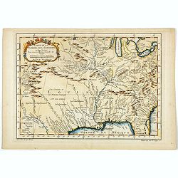
Carte de la Floride, de la Louisiane, et Pays Voisins. . .
Jacques Nicolaas Bellin (1703-1772) was one of the most important and proficient French cartographers of the mid-eighteenth century. He was appointed the first Ingenieur ...
Date: Paris, 1757
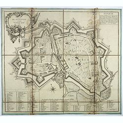
Plan de Hanover.
Town-plan of Hanover, with the new town of St Aegidien built in 1747. Decorated with a title cartouche and accompanied by a numbered key (1-79) of the main streets and bu...
- $200 / ≈ €169
Date: Paris, 1757
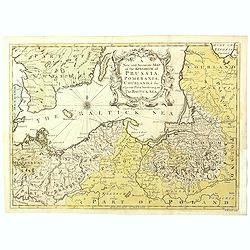
A New and Accurate Map of the Kingdom of Prussia, Pomerania, Courland & the Adjacent Parts Bordering on the Baltick Sea.
Attractive uncommon detailed map of the Kingdom of Prussia and the neighbouring regions, showing much of modern day Poland. Published in 'Universal Magazine', and well en...
- $750 / ≈ €635
Date: London, 1757
![[Lot of 8 maps of European Russia] Partie Septentrionale de la Russie Europeenne ou sont distinguees exactement toutes les Provinces](/uploads/cache/18563-(3)-250x250.jpg)
[Lot of 8 maps of European Russia] Partie Septentrionale de la Russie Europeenne ou sont distinguees exactement toutes les Provinces
[Lot of 8 maps of European Russia]- Partie Septentrionale de la Russie Européenne òu sont distinguées exactement toutes les Provinces (1753)- Carte des Pais Habites p...
- $600 / ≈ €508
Date: Atlas Universel PARIS 1757
![[Title page and 17 text pages ] Atlas Universel. . .](/uploads/cache/47722-250x250.jpg)
[Title page and 17 text pages ] Atlas Universel. . .
Beautiful title-frontispiece from the famous universal atlas initiated by geographers Gilles Robert and his son Didier Robert de Vaugondy, revised, corrected and enhanced...
- $450 / ≈ €381
Date: Paris, 1757
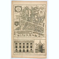
Tower Street Ward with their Divisions into Parishes according to a New Survey.
A fascinating plan of Tower Street Ward, one of the 25 City of London Wards. It lies close to The Tower of London. Much of the ward was lost to Billingsgate Ward in bound...
Date: London, 1757
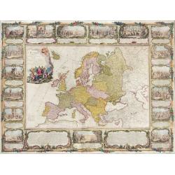
L'Europe divisée en tous ses états, dressée sur les nouveaux mémoires et suivant les dernières observations.
Rare wall map of the European continent, published by the Parisian publisher Sébastien G. Longchamp.The map is surrounded by a magnificent Rococo-style frame decorated w...
Date: Paris, 1757
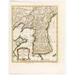
Carte de la province de Quan-tong, ou Lyau-tong et du Royaume de Kau-li ou Corée.
Map of Korea. The map is of interest for the use of East Sea, the sea between Korea and Japan, here called "Mer de Corée. With Seoul named, King-Ki-TaoDecorative ti...
Date: Paris, 1757

RESTORED CROSSTAFF SEGMENT
RESTORED CROSSTAFF SEGMENT, Dutch, 1757, signed “I*v*K” for Johannes van Keulen, dated “1757” and numbered “23.” The staff is made of ebony, 11/16” (18 mm)...
Date: Amsterdam, 1757
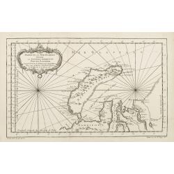
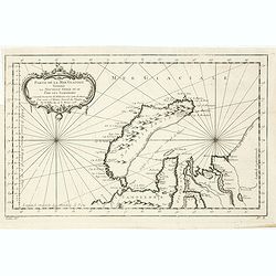
Partie de la Mer Glaciale contenant de la nouvelle Zemble..
A good engraved map of Nova Zembla. The geographical features are typical with somewhat exaggerated bays and inlets. From l'Histoire générale des voyages .
- $80 / ≈ €68
Date: Paris, 1758
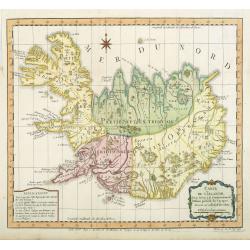
Carte de l'Islande pour servir á la continuation de l'histoire générale des voyages. Dressée sur celle de M. Horrebows.
A good engraved map of the island Iceland, prepared by Bellin after M. Horrebows, with rococo title cartouche in lower right. From l'Histoire générale des voyages.
- $300 / ≈ €254
Date: Paris, 1758
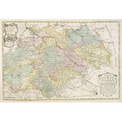
Neue Karte des Kuhrfürstenthums Sachsen. . .
Scarce road map, first published by Peter Schenk II (1698-1775) in his "Neuen Sächsischen Atlas". It is based on a map already created and 1732 and improved in...
- $750 / ≈ €635
Date: Amsterdam, 1758
Partie De La Mer Glaciale Contenant La Nouvelle Zemble et Le Pais Des Samoiedes . . . 1758
Detailed map of Nova Zembla and part of the Northeast passage.From Prevost's l'Histoire générale des voyages , the map prepared by J.N. Bellin. Jacques Nicolas Bellin (...
- $60 / ≈ €51
Date: Paris, 1758
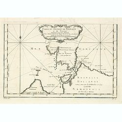
Carte du Detroit de Waigats ou de Nassau. . . 1758. N°.2.
Showing the Dutch voyage of 1594 which proved Nova Zemlya was an island separated from the continent by the "le Waigats Detroit". Several sounding shown.From Pr...
- $40 / ≈ €34
Date: Paris, 1758
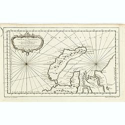
Partie De La Mer Glaciale Contenant La Nouvelle Zemble et Le Pais Des Samoiedes . . . 1758
Detailed map of Nova Zembla and part of the Northeast passage.From Prevost's l'Histoire générale des voyages , the map prepared by J.N. Bellin. Jacques Nicolas Bellin (...
- $50 / ≈ €42
Date: Paris, 1758

Kort begrip der oude en nieuwe staatkundige Geographie: behelzende eene beschryving der heerschappyen, in welken de aarde verdeeld is, haare gelegenheid. . .
Sixth edition- Interesting geographical compendium, prepared by Johann Hubner en W.A. Bachiene. Of particular interest is the section starting with pages 589 with "O...
Date: Amsterdam, Covens / Mortier, Utrecht, Poolsum, 1758
![[Lot of 6] Carte de la Baye d'Hocsieu. Fukin. (3 Maps + 3 Gravure of China)](/uploads/cache/IMG_2524-250x250.jpg)
[Lot of 6] Carte de la Baye d'Hocsieu. Fukin. (3 Maps + 3 Gravure of China)
[Lot of 6 items]. (3 Maps +3 gravure )- Carte de la Baye d'Hocsieu et des Entrees de la Riviere de Chang Situees dans la Province de Fokyen. J.N.Berlin 1748- Carte de l�...
Date: Amsterdam, 1759
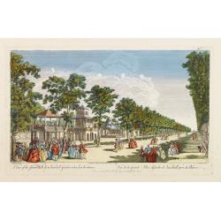
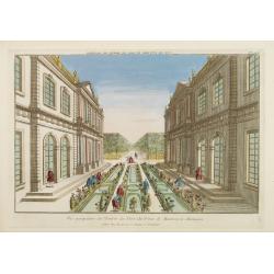
A View of the Grand Walk &c in Vauxhall gardens taken from the Entrance. Publish'd according to Act of Parliament..
So-called optical print illustrating Vauxhall gardens.In the eighteenth and nineteenth centuries, there were many popular specialty establishments in Paris, Augsburg and ...
Date: London, 1759
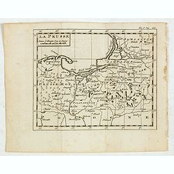
La Prusse.
Fine miniature map of Prussia, likely published by Claude Buffier. In upper right corner "Tom.I. Pag. 283.
- $150 / ≈ €127
Date: Paris, ca. 1759

A new & accurate map of the Empire of China from the Sieur Robert's Atlas. With improvements.
An excellent early engraving of China and Korea that appeared in Sieur Robert de Vaugondy's Geographical Dictionary (London: 1759). Decorative title cartouche on the uppe...
Date: London, 1759
![[Title page] Schauplatz des gegenwaertigen kriegs . . .](/uploads/cache/37918-250x250.jpg)
[Title page] Schauplatz des gegenwaertigen kriegs . . .
Title page from Schauplatz des gegenwaertigen kriegs . Very fine, typical German title page with cannons, flags, trumpets, etc.Gabriel Nikolaus Raspe (1712-1785) was acti...
- $200 / ≈ €169
Date: Nuremberg, 1759
![[Title page] Schauplatz des gegenwaertigen kriegs . . .](/uploads/cache/37919-250x250.jpg)
[Title page] Schauplatz des gegenwaertigen kriegs . . .
Title page from Schauplatz des gegenwaertigen kriegs . Very fine, typical German title page with cannons, flags, trumpets, etc.Gabriel Nikolaus Raspe (1712-1785) was acti...
- $150 / ≈ €127
Date: Nuremberg, 1759
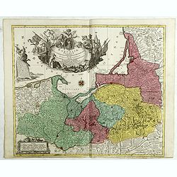
Borussiae Regnum compectens Circulos Sambiensem, Natangiensem, et Hockerlandiae Nee non Borussia Polonica, exhibens Palatinatus Culmiensem. . .
Decorative map covering northern Poland with Prussia, Pomerania, Hockerlandia, Warmiaermelandia, Natanglensis, Galindia, Nandrovia, Sclavonia, and the Baltic Sea. Include...
Date: Augsburg, 1759
![[Title page with 2 text pages for ] Schauplatz des gegenwaertigen kriegs . . .](/uploads/cache/47917A-250x250.jpg)
[Title page with 2 text pages for ] Schauplatz des gegenwaertigen kriegs . . .
Title page from Schauplatz des gegenwaertigen kriegs, with 2 other pages. Very fine, typical German title page with cannons, flags, trumpets, etc.Gabriel Nikolaus Raspe (...
- $150 / ≈ €127
Date: Nuremberg, 1759
![[Title page] Atlas portatif des militaires et des voyageurs. . .](/uploads/cache/47745-250x250.jpg)
[Title page] Atlas portatif des militaires et des voyageurs. . .
Title page of Atlas portatif des militaires et des voyageurs published by Georges-Louis Le Rouge in 1759.
- $175 / ≈ €148
Date: Paris, 1759
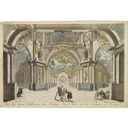
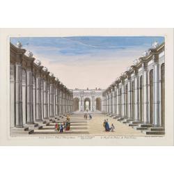
Vue des trois Gallerie, du Palais des Arts..Science a Rome.
So-called optical print. Daumont was a well-known publisher of optical prints, established in Paris. In the eighteenth and nineteenth centuries there were many popular sp...
Date: Paris, 1760
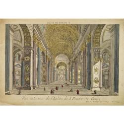
Vue interieur de l'Eglise de S.Pierre de Rome.
So-called optical print of St. Pieter church of Rome. A well-known publisher of optical prints, established in Paris. In the eighteenth and nineteenth centuries there wer...
Date: Paris, 1760
Vue perspective de la Grande Place de St.Francois a Seville.
So-called optical print. Daumont was a well-known publisher of optical prints, established in Paris. In the eighteenth and nineteenth centuries there were many popular sp...
Date: Paris, 1760
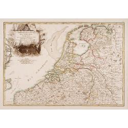
Partie Septentrionale des Pays Bas..
"Detailed map covering the Low Countries, published by Jean Latré."
- $400 / ≈ €339
Date: Paris 1760

Vue Interieure de la Bourse Royale à Londres.
So-called optical print of the London stock exchange. Daumont was a well-known publisher of optical prints, established in Paris. In the eighteenth and nineteenth centuri...
Date: Paris, 1760
Der Zeug=Platz gegen S.Morizen Plaz zu Augspurg.
A well-known publisher of optical prints, established in Augsburg.In the eighteenth and nineteenth centuries there were many popular speciality establishments in Paris, A...
- $200 / ≈ €169
Date: Augsburg, 1760
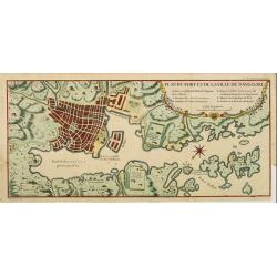
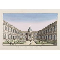
Plan du port et de la ville de Nangasaki.
This plan originates from Charlevoix's work Histoire et description Générele du Japon . His first in 1715 published work was the Histoire de l'etablissement du christia...
- $600 / ≈ €508
Date: Paris, 1760
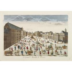
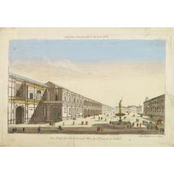
Le Grand Marché de Vienne.
Optical view of the Large Market Square in Vienna by Huquier, a well-known publisher of optical prints, established in Paris.In the eighteenth and nineteenth centuries, t...
- $200 / ≈ €169
Date: Paris 1760
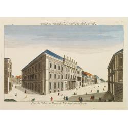
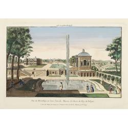
Vue du Palais du Prince de Liechtenstein à Vienne.
Optical print of the palace of the Price of Liechtenstein in Vienna by Huquier, a well-known publisher of optical prints, established in Paris.In the eighteenth and ninet...
- $200 / ≈ €169
Date: Paris, 1760
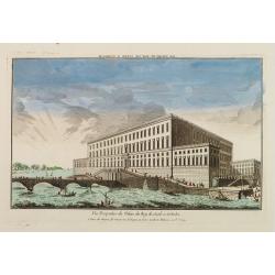
Vue Perspective du Palais du Roy de Suede a Stokolm.
Perspective view of The Stockholm Palace by Huquier, a well-known publisher of optical prints, established in Paris.In the eighteenth and nineteenth centuries there were ...
Date: Paris 1760
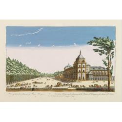
A view of the palace plaisans of Reyn Hongres...
So-called optical print of Aranjuez Palace near Madrid, and wrongly described as situated near to Vienna. Publishedby Huquier, a well-known publisher of optical prints, e...
- $125 / ≈ €106
Date: Paris, 1760
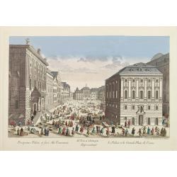
81e. Vue d'Optique Reprsentant Le Palais et la Grande Place de Vienne.
Optical print of a square in Vienna, by Daumont who was a well-known publisher of optical prints, established in Paris.In the eighteenth and nineteenth centuries there we...
Date: Paris, 1760
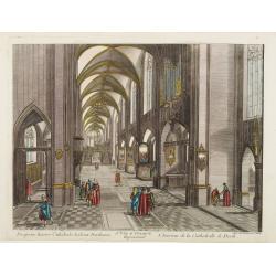
13e. Vüe d'Optique Representant L'Interieur de la Cathedralle de Dorth.
Optical view representing the interior of a Cathedral in Dörth, near Wiesbaden. Published by Daumont, a well-known publisher of optical prints, established in Paris.In t...
- $200 / ≈ €169
Date: Paris, 1760
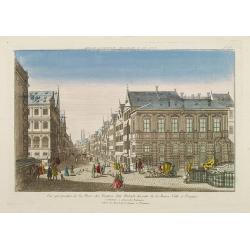
Vue perspective de la Place des Peintres ditte Perlach du cote de la Basse Ville a Prague.
A so-called optical print of a square in Prague by Basset, a well-known publisher of optical prints, was established in rue S.Jacques in Paris. With brief key list.In the...
- $300 / ≈ €254
Date: Paris, 1760
Vue perspective de l'Entrée du Parc du Prince de Manheim en Allemagne.
Perspective view of the Royal Park in Manheim by Basset, a well-known publisher of optical prints, established in rue St.Jacques in Paris. With brief key list.In the eigh...
- $200 / ≈ €169
Date: Paris, 1760
15e. Vüe d'Optique Representant Le Profil du Palais de Petersbourg.
So-called optical print illustrating a perspective view of the portico of a Palace in Saint Petersburg. Published by Daumont, a well-known publisher of optical prints, es...
- $250 / ≈ €212
Date: Paris, 1760
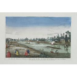
Vue perspective de la Ville et Forteresse Electorale de Koningstein, et de la Montagne de Lilienstein avec ses environs du côté du Couchant, dépendant des Etats de Saxe, appartenant à Sa Majesté le Roy de Pologne.
Perspective view of Königstein fortress, situated near to Dresden in Saxony. To the left the Fortress and in the foreground the river Elbe. The castle was inhabited by A...
Date: Paris, 1760
Vüe de Morestburg en Saxe, l'une des Maisons de Chasse du Roy de Pologne. (Castle Moritzburg)
So-called optical print illustrating a perspective view of the Castle Moritzburg, a Baroque Germanic castle in the small town of Moritzburg in the German state of Saxony....
- $250 / ≈ €212
Date: Paris, 1760

Vuë de l'ancien Palais d'hiver de sa Majesté Imperiale et du Canal qui Joint la Moika avec la Neva, a St. Petersburg.
So-called optical print illustrating a perspective view of St. Petersburg, namely the ancient Winter Palace and the canal which joins the Moika to the Neva.In the eightee...
Date: Paris, 1760
A view of BILNITZ in Saxony one of the palaces of the King of Poland. / Vüe de Bilnitz, en Saxe, un des Palais du Roi de Pologne.
So-called optical print illustrating a perspective view of Pillnitz Castle, a restored Baroque castle at the eastern end of the city of Dresden. The castle was once the s...
- $300 / ≈ €254
Date: Paris, 1760
Vuë Perspective de l'interieur du superbe Palais du Prince Eugene.
So-called optical print illustrating a perspective view of Prince Eugene of Savoy's palace. After a design of Kleiner.In the eighteenth and nineteenth centuries, there we...
- $195 / ≈ €165
Date: Paris, 1760
Vue de la Fontaine des Eaux chaudes et de la place d'Aix la Chapelle.
So-called optical print illustrating a perspective view of Aachen, in Nordrhein Westphalia, and namely the Elisa Fountain which contains two fountains with thermal water....
- $250 / ≈ €212
Date: Paris, 1760
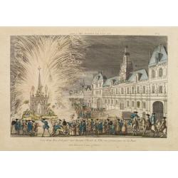
Vue d'un Feu d'Artifice tiré devant l'Hotel de Ville en réjouissance de la Paix.
Optical view, illustrating a fireworks display in front of the Paris city hall.In the eighteenth and nineteenth centuries there were many popular speciality establishment...
Date: Paris 1760
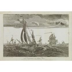
108e. Vaisseaux en pleine Mer.
Optical print of a fleet, by Daumont who was a well-known publisher of optical prints, established in Paris.In the eighteenth and nineteenth centuries there were many pop...
- $250 / ≈ €212
Date: Paris 1760
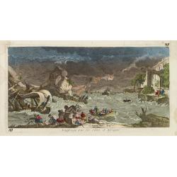
Naufrage sur les côtes d'Afrique.
So called optical print of a shipwrecking in a storm off the African shores.In the eighteenth and nineteenth centuries there were many popular specialty establishments in...
- $300 / ≈ €254
Date: Paris, 1760
La Feste du Poids au Mogol qui se célebre chez ses Peuples avec grande vénération.
So-called optical print illustrating a perspective view of a square in Mongolia.Mondhare, active at rue St.Jacques a l'Hotel Saumur, was a well-known publisher of optical...
Date: Paris, 1760
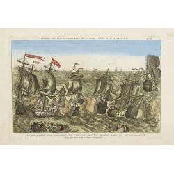
Vue perspective d'une rencontre des François avec les Anglois dans la Mediterranée.
Perspective view illustrating a battle between the French and the English fleets by Basset, a well-known publisher of optical prints, established in rue S. Jacques in Par...
- $300 / ≈ €254
Date: Paris, 1760
De Maria kerk te Leiden.
In the eighteenth and nineteenth centuries, there were many popular speciality establishments in Paris, Augsburg and London that produced optical viewing devices and spec...
- $200 / ≈ €169
Date: Paris, 1760
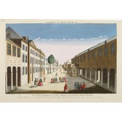
Vue d'Ausbourg prise de la Cathedrale regardant vers la Porte de la Sainte Vierge.
Charming view of the Cathedral (Dom St. Maria) in Augsburg. In top of the print the title, in mirror image, in manuscript. Published by André Basset, the younger engrave...
- $100 / ≈ €85
Date: Paris, ca 1760
L'Amerique divisée en ses principaux Etats..
Uncommon map published by Lattré. This map is most notable for its depiction of "Mer de L'Ouest" or "Sea of the West". A great sea, easily the size o...
- $900 / ≈ €762
Date: Paris, 1760
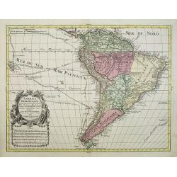
America Meridionalis.
This is the more scarce edition with the title cartouche lower left surrounded by Neptune and a native Indian.A rather accurate depiction and descriptions of South Americ...
- $550 / ≈ €466
Date: Augsburg, c. 1760
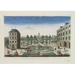
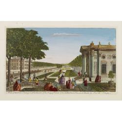
Vue et perspective d'un Jardin du Roy d'Angleterre aux environs de Londres.
So-called optical print of one of the King's Royal Gardens in the London vicinities.Published by the brothers Chéreau, active in Paris at rue St. Jacques au dessus de la...
- $150 / ≈ €127
Date: Paris, 1760
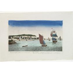
Prospectus Purfleet ad Tamesim in Comitatu Essex Representant le Purfleet sur la Tamise dans le Comté d'Essex. 21e VUE d'Optique.
A so-called optical print of the vessel Purfleet navigating on the River Thames in Essex, England. Published by the brothers Chéreau, active in Paris at rue St. Jacques...
- $300 / ≈ €254
Date: Paris, 1760
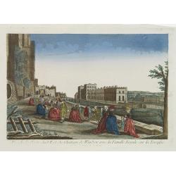
Vue de la Partie Sud Est du Château de Windsor avec la Famille Royale sur la Terrasse. Et vue du Palais de la Reine.
A so-called optical print view of the Royal family at the terrace of the South East wing of Windsor Castle as well as the Queen's Palace. Published by the brothers Chére...
- $200 / ≈ €169
Date: Paris, 1760
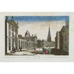
Universatis ae Reginae Collegiorum prospectus Oxfordiae Représentant le College de l'Université, et celui de la Reine a Oxford. 63 Vue d'optique.
A so-called optical print of Queens College on High Street in Oxford. As most optical prints, due to the fact that they are used to be looked at in a mirror, the subject ...
- $275 / ≈ €233
Date: Paris, 1760
Vue d'une des Maison de Plaisance et d'une partie du Parc du Comte de Burlington du Coté de la Tamise.
A so-called optical print of Burlington County and the River Thames. Published by the brothers Chéreau, active in Paris at rue St. Jacques au dessus de la Fontaine St. S...
- $225 / ≈ €191
Date: Paris, 1760
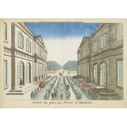
Entree du parc du Prince à Manheim.
Perspective view of the Royal Park in Manheim by Basset, a well-known publisher of optical prints, established in rue St.Jacques in Paris. With a brief key list.In the ei...
- $75 / ≈ €64
Date: Paris, 1760
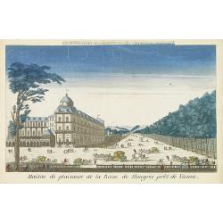
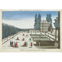
Maison de plaisance de la reine de Hongrie pres de Vienne.
Perspective view of the castle of the queen of Hungary near Vienna. Basset was a well-known publisher of optical prints, established in rue St.Jacques in Paris. With brie...
Date: Paris, 1760
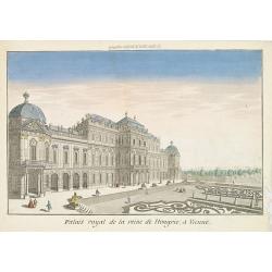
Palais royal de la reine de Hongrie à Vienne.
Perspective view of the royal palace of the queen of Hungry, in Vienna, a well-known publisher of optical prints, established in rue St.Jacques in Paris. With brief key l...
Date: Paris, 1760
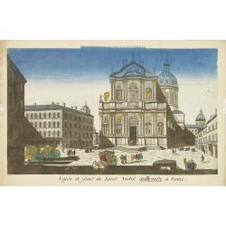
Eglise et place de Saint Andre dellavalle à Rome.
Perspective view of the church and place Sant'Andrea della Valle church in Rome. Sant'Andrea della Valle later became a model for the construction of other churches like ...
Date: Paris, 1760

Belgica Foederata. . .
Decorated with a cartouche showing the coats of arms of Zeeland, Holland, Utrecht, Friesland, Groningen and Overijssel. T.C. Lotter married M. Seutter's daughter in 1740 ...
Date: Augsburg, ca.1760
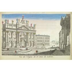
Vue de l'eglise de St Jean de Latran.
So-called optical print of the church Saint Jean de Latran, by Basset a well-known publisher of optical prints, established in rue St.Jacques in Paris. With brief key lis...
- $150 / ≈ €127
Date: Paris, 1760
Maison de plaisance près de Parme.
So-called optical print of a country house near Parma, by the well-known publisher of optical prints, Basset, established in rue St.Jacques in Paris.In the eighteenth and...
- $150 / ≈ €127
Date: Paris, 1760
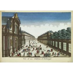
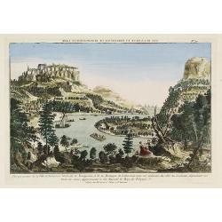
Vue d'un château d'Archangel.
So-called optical print of a street and house in Arkhangelsk, by the well-known publisher of optical prints, Basset, established in rue St.Jacques in Paris. In the eighte...
- $300 / ≈ €254
Date: Paris, 1760

6e Vüe d'Optique Représentant Le Chœur de la Cathedrale de St. Paul de Londres.
So-called optical print illustrating a perspective view of the interior of the Saint Paul Cathedral in London.In the eighteenth and nineteenth centuries there were many p...
Date: Paris, 1760

5e Vue d'Optique Representant La Vue interieure de la Cathedralle de St. Paul de Londres.
So-called optical print illustrating a perspective view of the interior of the Saint Paul cathedral in London. Engraved by la Marcade.In the eighteenth and nineteenth cen...
Date: Paris, 1760
40e Vue d'Optique Representant Le Parc Royal de St. James a Londres.
So-called optical print illustrating a perspective view of Saint James Park, in London.In the eighteenth and nineteenth centuries there were many popular speciality estab...
- $250 / ≈ €212
Date: Paris, 1760

39e Vüe d'Optique Representant L'Hotel du Lord Maire de Londre.
So-called optical print illustrating a perspective view of Somerset House on the Strand in London.In the eighteenth and nineteenth centuries there were many popular speci...
Date: Paris, 1760

26e Vüe d'Optique Representant L'Abbaye de Westminster et de l'Eglise Ste. Marguerite à Londres.
So-called optical print illustrating a perspective view of the Westminster Abbey, in London.In the eighteenth and nineteenth centuries there were many popular speciality ...
Date: Paris, 1760

Vuë du dedans de l'Eglise de St. MARTIN à Londre.
So-called optical print illustrating a perspective view of the central aisle of St. Martin's church, in London.In the eighteenth and nineteenth centuries there were many ...
Date: Paris, 1760

Vüe Perspective du Pont neuf construit sur la tamise a Hampton-Court.
So-called optical print illustrating a bridge on the river Thames at Hampton-Court.In the eighteenth and nineteenth centuries there were many popular speciality establish...
Date: Paris, 1760