Browse Listings
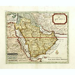
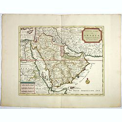
Carta nuova dell'Arabia.
Detailed map of Arabia and environs. Based on a map published by Isaak Tirion in Amsterdam, but here issued by Albrizzi with a modified title.More about Mapping of Arabia...
Date: Venice, 1740
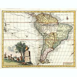
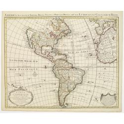
Carta geografica della america meridionale.
Uncommon map of South America based upon Guillaume De L'Isle's map. Includes the routes of early explorers in the Pacific, including Magellan, Drake, Le Maire, Mendana, V...
Date: Venice, 1740
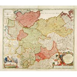
Circulus Saxoniae inferioris.
Detailed map of Saxen, including Bremen, Berlin, Lübeck, etc. Johann Baptist Homann (1663-1724) was a German engraver and publisher, who established himself and his fami...
- $200 / ≈ €170
Date: Nuremberg 1740
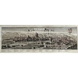
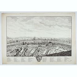
Fiorenza.
A spectacular largescale panoramic view of Florence taken from Montoliveto, with legends numbered from 1- 63 in Italian. With the title in a banderol. After a design by F...
Date: Augsburg, ca 1740
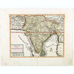
Impero del Gran Mogol.
Attractive copper engraved map of India with Sri Lanka. Showing mountains, towns and the Rama's Bridge (Ponte di Adamo). Included in "Atlante Novissimo che Contiene ...
Date: Venice, 1740
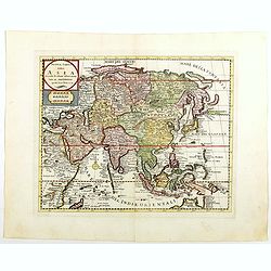
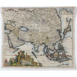
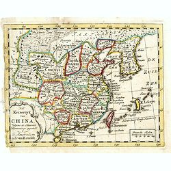
Nuova carta dell Asia . . .
Attractive and detailed map of Asia showing good detail in China, Mongolia, Tibet, Kamchatka, Japan, Kuriles, Korea, Manchuria, Formosa, Philippines, Indonesia Borneo, Ne...
Date: Venice, 1740
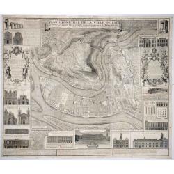
Plan Geometral de la Ville de Lyon.
A gigantic wall map of Lyon was originally issued in 1735 and revised in 1740. Engraved by Claude Seracourt and published by R.P. Grégoire in Lyon, France in 1740.This i...
Date: Lyon, ca. 1740
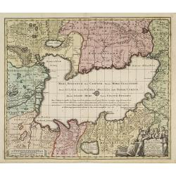
Nova et accuratissima Maris Caspii. . .
Original hand colored copper engraving of Matthaeus Seutter. Showing the Caspian Sea with the large Volga Delta in east orientation. Main towns / countries around the Cas...
- $750 / ≈ €636
Date: Augsburg, 1740

Paris.
A spectacular large-scale panoramic view of Paris, with legends numbered from 1-70 in French. With the title in a banderol.After a design by Friedrich Bernhard Werner (16...
Date: Augsburg, ca. 1740
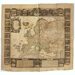
L'Europe Dressée Sur les Nouvelles observations. . .
A rare and monumental wall map of Europe, with original outline color, of four joined sheets, surrounded by text and vignettes printed on separate sheets.Created in 1740 ...
Date: Paris, 1700-1740
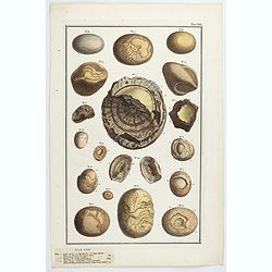
Lapides Bezoar ex Hippototamo, vel Equo marino. Tab CXII.
Natural history aroused the passion of wealthy collectors in the 17th and 18th centuries. These constitute vast "cabinets of curiosities" and sometimes undertak...
- $90 / ≈ €76
Date: Amsterdam, ca 1740

Carte de L'Egypte de la Nubie de L'Abissinie..
Prepared by G.de l'Isle. Uncommon issue by Hendrik de Leth. Very detailed map of northeastern Africa, the Red Sea and the Arabian peninsula shows the political divisions ...
- $500 / ≈ €424
Date: Amsterdam 1740
Asia Accuratissime Descripta ex omnibus, quae hactenus extiterunt, imprimis…
A rare map prepared by Nicolas Witsen (1640-1717). Witsen was cartographer, diplomat and sometime burgomaster of Amsterdam, he played a unique role in introducing Russian...
- $500 / ≈ €424
Date: Amsterdam, 1740
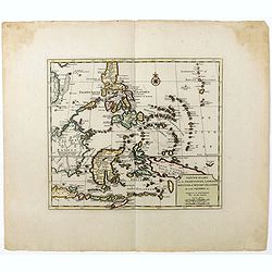
Nieuwe kaart van de Filippynsche, Ladrones, Moluccos of Specery Eilanden als mede Celebes etc.
Shows the western islands of the archipelago, Borneo, Java and Sumatra, up to and including New Guinea. With very good detail to Philippines.Read more Early maps of South...
Date: Amsterdam, 1740
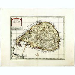
Isola Ceilon.
Attractive copper engraved map of Sri Lanka showing mountains, Towns and the Rama's Bridge (Ponte di Adamo). Included in "Atlante Novissimo che Contiene Tutte le Par...
Date: Venice, 1740
Nieuwe kaart van Arabia.
Here is an attractive map of the Arabian Peninsula, Gelukkig Arabia or Happy Arabia. The map is a great advance on other maps of the time by showing the true extent of...
Date: Amsterdam, 1740
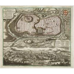
Prospectus Sanctae olim.. Hierosolymae.. Jerusalem. . .
Two bird's eye perspectives views of Jerusalem. Each with an extensive numbered key to principal buildings in town. Title in Latin and German. The print is published by M...
Date: Augsburg, 1740
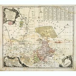
Praefecturae Principatus Querfurtensis Dahmiana et Iüterboccensis cum vicinia oppidis, vicis, pagis accurate distincta. . .
Showing the region of Ämter Dahme, Jüterbog, Baruth. With in the north Potsdam and in the south Schönwalde, in the west Brück/ Zahna and in the east Buchholz/ Luckau.
- $50 / ≈ €42
Date: Augsburg, ca. 1740
Dominia Anglorum in praecipuis Insulis Americae ut sunt Insula S. Christopheri, Antegoa, Iamaica, Barbados nec non Insula Bermudes vel Sommers . . .
Four maps of the islands of West Indies (St. Christoph "Delineatio Insulae St, Christophori alias I. Kitts", Antigua "Insula Antegoa", Barbados &q...
- $500 / ≈ €424
Date: Nuremberg, 1740
Accurata recens delineata ichnographia celeberrimæ liberæ Imperii civitatis ac Sueviæ metropolis Agustæ Vindelicorum -Neu verfertigt accurater ... Haupt Stadt Augspurg.
Superb plan of the fortified town of Augsburg, brilliantly colored at the time, with title in Latin and German. The plan was designed by Johann Thomas Kraus, engraver, ar...
- $1200 / ≈ €1017
Date: Nuremberg, ca. 1740
![[Portrait] Johannes Baptista Homann . . .](/uploads/cache/44363-250x250.jpg)
[Portrait] Johannes Baptista Homann . . .
Stunning full portrait of the Imperial Geographer of the Holy Roman Empire, Johann Baptist Homann (1664-1724) who was born in the Bavarian town of Kammlach. Educated at a...
Date: Nuremberg, c.1740
Delineatio Geographica Ditionis Martisburgensis hodie regiis et electoralibus auspiciis florentis edita. . .
Map shows the surrounding of the city of Halle. With a very large title cartouche occupying the lower left corner. Engraved by Tobias Conrad Lotter.
- $75 / ≈ €64
Date: Augsburg, 1740
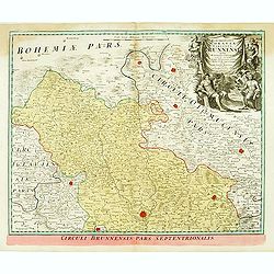
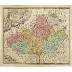
Marchionatus Moraviae circulus brunnensis. . .
Johann Baptist Homann's well-engraved map has a large decorative cartouche. Detailed map centered on Bruenn in Moravia. Prepared by Johann Chr. Mueller. Very decorative t...
- $300 / ≈ €254
Date: Nuremberg, 1740
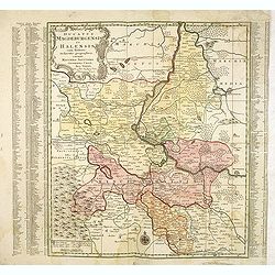
Ducatus Magdeburgensis Et Halensis cum finitimis Delineatio geographica. . .
Very decorative map centered on Magdeburg with Elbe river. With a key to the left and right of the map.
- $75 / ≈ €64
Date: Augsburg, ca. 1740
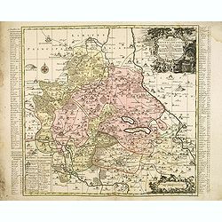
Delineatio geographica praefecturarum Wittebergensis et Graefenhaynichen; in circulo electorali sitarum. . .
Very decorative map of Mansfeld Land, a region in the southwestern corner of the German state of Saxony-Anhalt. The region derives its name from the counts of Mansfeld, w...
- $75 / ≈ €64
Date: Augsburg, ca. 1740
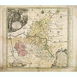
Delineatio geographica praefecturarum Wittebergensis, et Graefenhaynichen. . .
Showing Amt Wittenberge with the river Elbe. Wittenberge is a town of eighteen thousand people on the middle Elbe in the district of Prignitz, Brandenburg.
- $75 / ≈ €64
Date: Augsburg, 1740
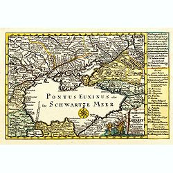
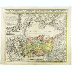
Die Europaeische oder kleine Tartarey, nebst den angraentzenden Laendern. . .
Showing the Black Sea region. Uncommon map from the "Atlas Selectus" by the German cartographer Johann Georg Schreiber (1676-1750). Schreiber followed in the fo...
- $450 / ≈ €382
Date: Leipzig, 1741

Carte particulière des environs de St Peters-bourg. . . / Plan de la ville faubourg et environs de St Petersbourg. . . / Carte pour l'intelligence de la guerre de Moscovie et de Suede. . .
A scarce and unusual plan of Saint Petersburg shown at a large scale and also, in a separate compartment, shown in its geographical context between the Gulf of Finland an...
Date: Paris, c.1741
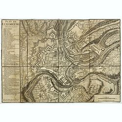
Plan de Luxembourg.
Beautiful engraved plan of the city of Luxembourg, accompanied by a table of references.
- $500 / ≈ €424
Date: Paris, 1741

Globe Terrestre Didié et Présénté a Monseigneur le Comté Maubec de Brancas...
A rare terrestrial globe dated 1741. Complete title "Globe Terrestre Didié et Présénté a Monseigneur le Comté Maubec de Brancas Par Jacque Hardy. Dres...
Date: Paris, dated 1741
Rom: Keyserl. Majest. Königl Hoher Allierten Kriegs Theatrum von Schlesien, Böhmen, Maehren u: Oestereich. . .
A rare map centred on Austria, eastern Germany, Poland and Tsjechië. In upper right corner an inset plan of Prague. Showing the situation of the first Silesian War of 17...
- $900 / ≈ €763
Date: Nuremberg, 1742
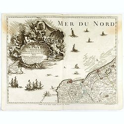
Carte des Pais Bas contenant la Flandre, le Brabant, Pais de Liege. . .
Map sheet from a multi-sheet map of the Low Countries, showing a large title cartouche and part of the Northern French coast line around Calais, Duinkerken and Furnes. Th...
- $75 / ≈ €64
Date: Paris, 1742

Kaartje van Asia. . .
Attractive and rare map of Asia. From Atlas Portatif . With a curious and oversized Hokkaido. The map is of interest for the use of Coreanse Zee for the sea between Korea...
Date: Deventer 1742
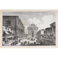
Aedis Divi Rocchi facies rudis…
The Campo San Rocco. Title centred in the lower margin; “Mich. Marieschi del.t et inci.t” at the right corner of the cartouche. From the series "Magnificentiores...
Date: Venice, c. 1742
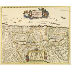
Novissima totius Terrae Sanctae sive promissionis. . .
Engraved by J.B.Homann and published by David Funck. One of the very few maps engraved by Johan Baptist Homann, signed lower right.A rare map of the Holy Land, orientated...
- $950 / ≈ €806
Date: Nuremberg, 1742
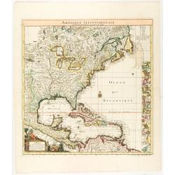
Amerique Septentrionale suivant la carte de Pople faite à Londres en 20 feuilles.
The key sheet to Henry Le Rouge/Popple wall map of the British Colonies in North America. Appears in the author's Atlas Général [1741-62].Key map of the French editio...
Date: Paris, Le Rouge, 1742

(Title page) Recueil Contenant des Cartes Nouvelles Dressées Sur des Morceaux.
Rare title page. Le Rouge was a military Ingenieur for fortifications. He was a map-maker for the army and Marine Royale. He was active between 1740 and 1780, in Paris at...
- $100 / ≈ €85
Date: Paris, 1742
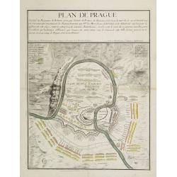
Plan de Prague.
Rare and separately published plan of Prague published by Joan Baptista Nolin with the address à l'enseigne de la Place des Victoires et chez le Sr. Humblot rue St. Jacq...
- $550 / ≈ €466
Date: Paris, ca. 1742
![[Title page] Atlas Coelestis in mundus spectabilis, et in eodem Stellarum](/uploads/cache/47437-250x250.jpg)
[Title page] Atlas Coelestis in mundus spectabilis, et in eodem Stellarum
Title page from the first edition of this celestial atlas.
Date: Nuremberg 1742
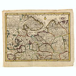
'T Noorderdeel van Moscovie Na de stelling van G. de L'Isle. . .
Attractive and rare map of part of Russia, including St. Persburg, Archangel, Finland, Lapland and Moscow. From Atlas Portatif .
- $100 / ≈ €85
Date: Deventer, 1742

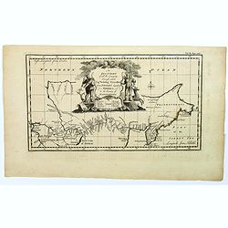
Kaartje van Asia. . .
Attractive and rare map of Asia. From Atlas Portatif . With a curious and oversized Hokkaido. The map is of interest for the use of Corease Zee for the sea between Korea ...
Date: Deventer, 1742
Carte de l'Asie Minevre ou de la Natolie et du Pont Euxin...
A map centered on the Black Sea and the geographical regions surrounding it. The map shows Asia Minor, Crete, Cyprus, northern Syria, Iraq, Georgia, Crimea, Bulgaria, Rom...
Date: Nuremberg, 1743

ANNA IWANOVNA - Anna Ioannovna imperatricea i camoderschiza wserossinskaja (rossice). Anna Joannowna imperatrix totius Russiae
Extremely rare half portrait print of Anna Ivanovna (7 February [O.S. 28 January] 1693, Moscow – 28 October [O.S. 17 October] 1740) reigned as Duchess of Courland from ...
Date: St. Petersburg, 1743

ELISABETH I. - Elisabet imperatriza wseros sinskaja petra welikago dscherj (rossice). Elisabetha imperatrix. Omnium Russiarum Petri. Magni. Filia.
Extremely rare half portrait print of Elizaveta Petrovna (29 December [O.S. 18 December] 1709 – 5 January 1762 [O.S. 25 December 1761] ), also known as Yelisavet and El...
Date: St. Petersburg, 1743

FJODOR JOANNOWITSCH - Feodor Ioannowitsch zar i camoderschez wserossinskij (rossice). Feodor Ioannowicz tzaar et autocrator totius Russiae Joann Alexiewicz tzaar et autocrator totius Russiae.
Extremely rare half portrait print of Czar Fyodor I Ivanovich (31 May 1557 – 16/17 January 1598) was the last Rurikid Tsar of Russia (1584 - 1598), son of Ivan the Terr...
Date: St. Petersburg 1743

Sr Walter Ralegh.
Copper engraved portrait of Sir Walter Raleigh (ca. 1554 – 1618) by Jacob Houbraken (1698 – 1780), from Thomas Birch's "The Heads of Ilustrious Persons of Great ...
- $350 / ≈ €297
Date: London, John and Paul Knapton, 1743

ALEXEI I. - Alexei Michailowitsch zar i camoderschez wserossinskij (rossice). Alexei Michailowicz tzaar et autocrator totius Russiae.
Extremely rare half portrait print of Czar Alexei Michailowicz..Aleksey Mikhailovich Romanov ( 9 March 1629 (O.S.) – 29 January 1676 was the Tsar of Russia during some ...
Date: St. Petersburg, 1743
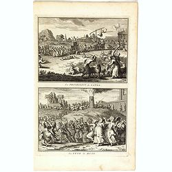
La procession de Ganga/ La fête de Huly.
Two scenes on one page showing religious scenes, in Japan. Fine copper engraving by Bernard Picart and taken from Bernard Picart's famous Céréonies et costumes religieu...
- $30 / ≈ €25
Date: Amsterdam, 1743

Imperii Russici et Tartariae Universae tabula novissima.
Decorative and rare map covering Russia, Tibet, China, Tartary, Korea, Taiwan and Japan prepared by J. M. Hasius. The sea between Japan and Korea is mentioned Mare Orient...
Date: Utrecht, 1743
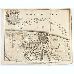
Plan of the Investiture of Ostend Surrenderd, 6 July, 1706
An interesting copper engraved plan of the Fortification of Doway in Flanders, with an attractive rococo cartouche, showing an overview of the battlefield and surrounding...
Date: London, 1743
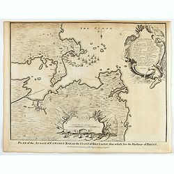
Plan of the Attack of Camaret Bay, on the coast of Bretagne, thro which lies the Harbour of Brest.
An interesting copper engraved plan of the Fortification of Camaret in Bretagne (France), with an attractive rococo cartouche, showing an overview of the battlefield and ...
Date: London, 1743
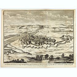
A view of Cassel, a very strong city in Italy, taken by the Duke of Savoy in Decem.r 1706
An interesting copper engraved plan of the Fortification of Cassel in Italy, with an attractive rococo cartouche, showing an overview of the battlefield and surrounding a...
Date: London, 1743

IWAN ALEXEJEWITSCH - Ioann Alexejewitsch zar i camoderschez wserossinskij (rossice).Joann Alexiewicz tzaar et autocrator totius Russiae.
Extremely rare print of Czar Ivan Alexejewitsch, who was the brother of Peter the Great.Johann Stenglin was a well known engraver, born at Augsburg in 1715, he studied un...
Date: St. Petersburg 1743
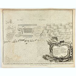
Plan of ye Battle of Wynendale between ye Troops of ye Allies commanded by Major Gen. Webb & those of France under Count de La Motte Sept. 28 1708.
An interesting copper engraved battle plan of Pinedale during the War of the Spanish Succession, showing the position of General Webb's troops in order to protect an alli...
Date: London, 1743
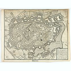
Mons the Capital City of Hainault in y Low Countries, taken by y French in 1691, Restor'd to y Spaniards by y Peace of Ryswick in 1697, retaken by y Allies in 1709, and left to y Emperor by y Treaty of Utrecht. .
An interesting copper engraved view of the walled city engraved by I. Basire, with pictographs of buildings. Many buildings and places are named on the map. Nicholas Tind...
Date: London, 1743
![[Manuscript chart on vellum of the Java Sea]](/uploads/cache/33613-250x250.jpg)
[Manuscript chart on vellum of the Java Sea]
One of the few manuscript charts on vellum in private hands, signed by Isaac de Graaf. ORIGINAL MANUSCRIPT MAP IN RED, GREEN AND BLACK INK showing the Java Sea centered o...
Date: Amsterdam, 1743
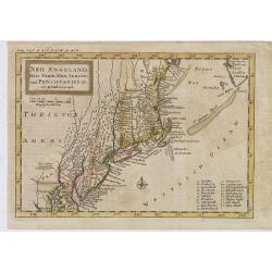
Neu Engeland Neu York, Neu Jersey und Pensilvanien & c. . .
The scarce German edition of Moll's popular and rather significant map which appeared in Oldmixon's 1708 book, Das Britische Reich in America. and then in other editions ...
Date: Lemgo, 1744

Allerneuester geographisch- und topographischer Schau-Platz von Africa und Ost-Indien. . .
An early issue of this important book by Johann Wolfgang Heydt's describing the Dutch factories, settlements and stations at the hands of the Dutch East India Company in ...
Date: Wilhermsdorf, Tetscher u. Nürnberg, Homanns Erben, 1744

Chaerte vande Wieringer waert, de welcke inden jaere XVI… (Wieringerwaard)
Rare wall map of the Wieringerwaard polder, as raffled on 12 July 1611. The polder was laid dry in 1610. It border, and the municipality's border, were the Zuiderzee, the...
Date: 1741-1744

A new & accurate map of Louisiana, with part of Florida. . .
An English view of North America compiled from available French maps, especially those of Bellin used in Charlevoix's History of New France. English cartographers had lit...
Date: London, 1744
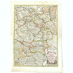
Tabula Generalis Marchionatus Moraviae..
Johann Baptist Homann's well-engraved map has a large decorative cartouche. Detailed map of the historic Moravia region of the Czech Republic, in the present-day Jihormor...
- $275 / ≈ €233
Date: Nuremberg 1744
![[Title page] Atlas Minor Praecipua Orbis Terrarum Imperia, Regna et Provincias , Germaniae Potissimum. . .](/uploads/cache/48479-250x250.jpg)
[Title page] Atlas Minor Praecipua Orbis Terrarum Imperia, Regna et Provincias , Germaniae Potissimum. . .
An attractive and highly decorative title page to Seutter's Atlas Minor. Engraved by Martin Crophius after Jacob Weyerman. The engraving is packed with lively figures fro...
Date: Augsburg, 1744
![[Title page Atlas Minor Praecipua Orbis Terrarum Imperia, Regna Et Provincias. . .]](/uploads/cache/47735-250x250.jpg)
[Title page Atlas Minor Praecipua Orbis Terrarum Imperia, Regna Et Provincias. . .]
Title page of Atlas Minor Praecipua Orbis Terrarum Imperia, Regna Et Provincias, drawn by Georg Matheus Seutter and his son Albrecht Carl. Georg Matheus was one of the mo...
Date: Augsburg, 1744
An exact chart of the countries through wich Capt. Behring travelled from Tobolsky capital of Siberia ti the country of Kamtschatka.
The earliest English language map to show Vitus Behring's Route.After retiring from a tour as Captain in the Czar's Navy, Behring, originally from Denmark, settled in Vyb...
- $200 / ≈ €170
Date: London, 1744
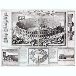
Anfiteatro detto l'Arena di Verona.
Large two sheet copper engraving of the Amphitheater of Verona after a design of Adriano Cristofali. On three sides it is surrounded by architectural details interspersed...
- $2200 / ≈ €1865
Date: Verona, 1744

Asia secundum legitimas projectionis stereographicae.
Highlighted area covers part of Spain, eastern coast of Ireland to western part of Papua New Guinea and the Asian continent from the Northern Polar Sea to the Indian Ocea...
Date: Nurenberg, 1744
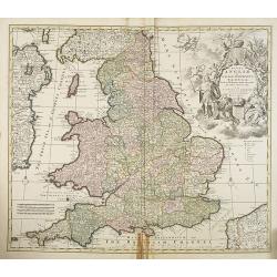
Regni Angliae et Wallae principatus Tabula, divisa in LII Regiones. . .
A detailed and decorative map of England, with an attractive uncolored title cartouche. The map is a re-issue of Carolus Allard's map. The elaborate title cartouche in th...
- $400 / ≈ €339
Date: Amsterdam c. 1744
![[2 maps and one text sheet] Theatrum Belli A° MDCCXXXVII. . . / Verus Chersonesi Tauricae Seu Crimea Conspectus adjacentium item Regionem itinerisq ab Exercitu Ruthemo...](/uploads/cache/27975-250x250.jpg)
[2 maps and one text sheet] Theatrum Belli A° MDCCXXXVII. . . / Verus Chersonesi Tauricae Seu Crimea Conspectus adjacentium item Regionem itinerisq ab Exercitu Ruthemo...
[2 maps and one text sheet] Theatrum Belli A° MDCCXXXVII. . . / Verus Chersonesi Tauricae Seu Crimea Conspectus adjacentium item Regionem itinerisq ab Exercitu Ruthemo A...
- $1100 / ≈ €933
Date: Amsterdam, c. 1744
Cours du Danube, Feuille 1 contenant LA SUABE . . .
Fine map of part of the River Danube, including the southern German province of Swaben.From his rare atlas "Theatre de la Guerre en Allemagne, contenant toutes les O...
Date: Paris, 1744
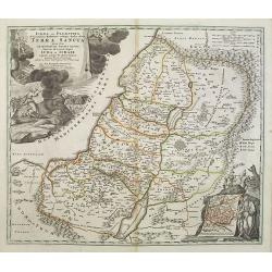
Judaea seu Palaestina .. Terra Sancta. . .
Johann Baptist Homann's well-engraved map has two large decorative cartouches. Upper left Moses receiving the Tables. Lower right Moses and Aaron pointing at a map showin...
Date: Nuremberg, 1744
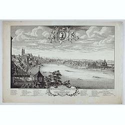
Prospect der Statt Basel von der St Alban Vorstraat - Vu¨e et perspective de la ville de Bâle du côté du Faubourg de St Albon.
Very decorative view of Basel, after a design by Emanuel Büchel and engraved by Johann Martin Weiss. Numbered 'No.1' in the bottom right, from a rare series of 4 sheets.
Date: Basle, ca. 1745
![[Lot of 3 maps] Carte de la Souveraineté de NEUCHATEL et VALLANGIN. Plus Mercator's and Blaeu's maps of the Wiflispurgergou]](/uploads/cache/18600-250x250.jpg)
[Lot of 3 maps] Carte de la Souveraineté de NEUCHATEL et VALLANGIN. Plus Mercator's and Blaeu's maps of the Wiflispurgergou]
Map of the lake of Neuchatel by Covens & Mortier. After the death of the widow of Pieter Mortier in 1719, the firm continued till 1778 as Covens & Mortier. They...
- $350 / ≈ €297
Date: Amsterdam, c. 1745
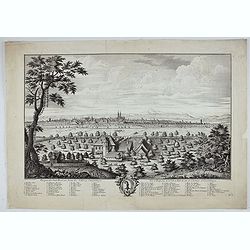
Prospect der Statt Basel von Seiten der Schlösser - Vuë et Perspective de la Ville de Bale du coté des Chateaux de Gundeldingue.
Very decorative view looking towards Basel from the castle at Gundeldingen, on a hill to the south. Accompanied at the bottom by a cartouche containing the arms of the ci...
Date: Basle, ca. 1745
Carte d' Amerique Dressee pour l'Usage Du Roy. . .
Detailed copper-engraved map of the American continent. Decorative title cartouche with foliate garland, and embellished lettering of d' Amerique. The western parts of Af...
- $1000 / ≈ €848
Date: Amsterdam c. 1745
![Carte de la coste orientale de la Chine depuis Amoy, jusqu'à Chusan avec une partie de l'Isle Formose [with] Plan du port d'Amoy ou Emouy.](/uploads/cache/33583-250x250.jpg)
Carte de la coste orientale de la Chine depuis Amoy, jusqu'à Chusan avec une partie de l'Isle Formose [with] Plan du port d'Amoy ou Emouy.
Important French chart of the China Sea with the coast of Northern China, including a large depiction of Formosa.Latitude and longitude scales, compass rose and system of...
Date: Paris, Jean-François Robustel, 1745
Het Keizerryk van China, volgens de Nieuwste Waarneminge opgesteld.
A scarce and uncommon miniature map of China, Korea and Taiwan. The map is of interest for the use of De Zuid Zee for the sea between Korea and Japan.
- $300 / ≈ €254
Date: Amsterdam, 1745
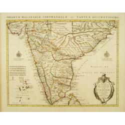
Carte des Côtes de Malabar et de Coromandel Presentée au Roy. . .
Large and attractive map of the Indian coasts of Malabar and Coromandel, embellished with title cartouche and 2 compass roses. It shows the most northern part of Ceylon.T...
- $500 / ≈ €424
Date: Amsterdam c. 1745
![Partie Septentrionale de la Souabe [and] Partie Meridionale de la Souabe. (2 maps)](/uploads/cache/21468-250x250.jpg)
Partie Septentrionale de la Souabe [and] Partie Meridionale de la Souabe. (2 maps)
Pair of maps forms a large, detailed view of Swabia, one of the ten circles of the Holy Roman Empire and containing some of the historically most interesting and cultural...
- $250 / ≈ €212
Date: Amsterdam c. 1745

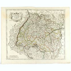
Carte de la Turquie, de l'Arabie et de la Perse..
Large map of the Near East, based upon earlier maps by De L'Isle. Shows also most part of the Mediterranean basin as well as north-eastern Africa. Relief shown pictoriall...
Date: Amsterdam c. 1745
Prospect der Statt Basel von Seiten der Kleinen Statt - Vüe et Perspective de la Ville de Bâle du côté de la petite Ville.
Very decorative view of Basle, after a design by Emanuel Büchel and engraved by Johann Martin Weiss. The legend inscribed under the engraving, numbered from 1 to 10, des...
Date: Basle, 1745

