Browse Listings
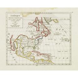
Amérique Septentrionale. . .
A fine small map of North America, extending from Hudsons' Bay to Panama, and including the West Indies. Dated 1748.From Atlas Portatif Universel, by Robert de Vaugondy.P...
- $200 / ≈ €170
Date: Paris, later than 1748
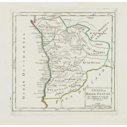
Congo ou Basse Guinée.
Nice small map showing a long stretch of the central Africa west coast and its hinterland. Centered on Luanda.From Atlas Portatif Universel, by Robert de Vaugondy. "...
- $75 / ≈ €64
Date: Paris, later than 1748
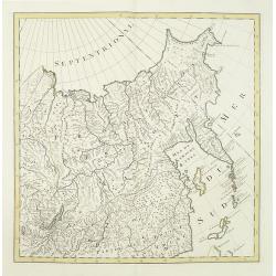
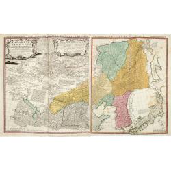
No title (Carte générale de l'empire de Russie).
The right hand sheet of a map of the Empire of Peter the Great.This important map is based on maps from the Bering expedition and on De L'Isle's Akademiia nauk Atlas of 1...
- $800 / ≈ €678
Date: Amsterdam, ca.1748
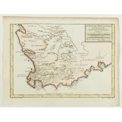
Le Pays des Hottentots aux environs du Cap de Bonne Espérance. . .
A good engraved map of Cape of Good Hope. The geographical features are typical with somewhat exaggerated bays, inlets and prominent mountain ranges. The west coast of th...
Date: Paris, 1748
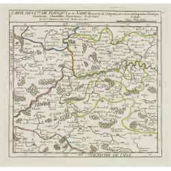
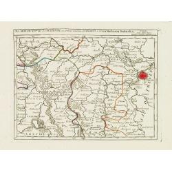
V. Carte des C.tes de Haynaut et de Namur. . .
Attractive small map illustrating part of the Walloon Region, centered on Charleroi. From Atlas Portatif Universel, by Robert de Vaugondy.Unrecorded state with erased dat...
- $30 / ≈ €25
Date: Paris, after 1748
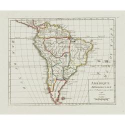
Amérique Méridionale.
Nice small map of South America. Dated 1748. From Atlas Portatif Universel, by Robert de Vaugondy.Page 105 outside border top right. Mary Sponberg Pedley does not mention...
- $75 / ≈ €64
Date: Paris, later than 1748
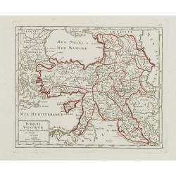
Turquie Asiatique..
Small detailed map of the Near East, including Cyprus, the Black Sea and Georgie. From Atlas Portatif Universel, by Robert de Vaugondy.Page 65 outside border top right. M...
- $100 / ≈ €85
Date: Paris, later than 1748
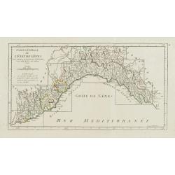
Carte Générale de l'Etat de Gênes.
Detailed map centered on the Gulf of Genoa. It shows the Italian region Liguria and extends westwards as far as Nice.Key map for the nine large-scale maps de Vaugondy mad...
- $100 / ≈ €85
Date: Paris, ca. 1748
![VIII. Carte de l'Etat de Genes [. . .] Toscane.](/uploads/cache/24551-250x250.jpg)
VIII. Carte de l'Etat de Genes [. . .] Toscane.
Detailed small map showing an area straddling the provinces of Genoa, La Spezia, Parma and Massa Carrara, Tuscany.Relief shown pictorially. From Atlas Portatif Universel,...
Date: Paris, later than 1748
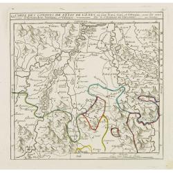
VI. Carte des Confins de l'Etat de Gênes où sont Novi, Gavi, et Ottagio..
Detailed small map encompassing the part of Piedmont between Alessandria, Tortona and Novi Ligure.Relief shown pictorially. From Atlas Portatif Universel, by Robert de Va...
- $150 / ≈ €127
Date: Paris, later than 1748

III. Carte de la Hollande.. Over-Yssel.
Attractive small map centered on the delta of the River Ijssel, where it discharges into the Zuiderzee.From Atlas Portatif Universel, by Robert de Vaugondy. Unrecorded st...
Date: Paris, later than 1748
V. Carte du Brabant ou se trouvét les Mair.s d'Herentals.. Hochstraten.
Nice small map illustrating the northeastern part of the Flemish region. Centered on Turnhout.From Atlas Portatif Universel, by Robert de Vaugondy. Unrecorded state with ...
- $50 / ≈ €42
Date: Paris, later than 1748
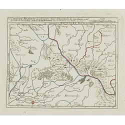
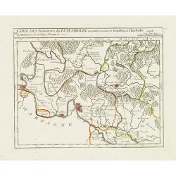
VI. Carte du Duché de Limbourg où sont les environs de Limbourg.
Attractive small map showing part of the Wallon region, centered on Limburg. Dated 1748. From Atlas Portatif Universel, by Robert de Vaugondy.Page 15f outside border top ...
- $45 / ≈ €38
Date: Paris, 1748

VI. Partie du Duche de Gueldre où se trouve la Veluwe.
Attractive small map covering the northwestern part of Gelderland. In the center "'t Loo". From Atlas Portatif Universel, by Robert de Vaugondy.Unrecorded state...
Date: Paris, later than 1748
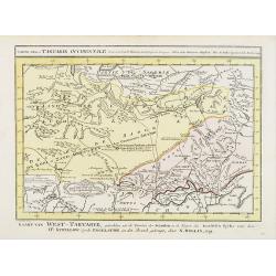
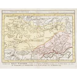
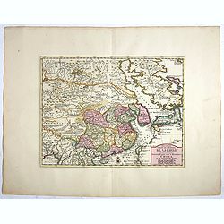
Carte de la Tartarie Occidentale.
Uncommon issue of this finely engraved map shows China's capital city of Peking, inland from the Gulf of Lyau-tong.The map locates in northeastern China to the border of ...
- $100 / ≈ €85
Date: Amsterdam, 1749
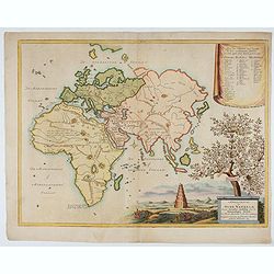
Afbeeldinge der Oude Waereld; Benevens Derzelver Verdeling Onder de Nakomelingen Noachs.
An interesting and uncommon map of the 'Old World' showing the continents of Europe, Asia, and Africa divided among Noah's sons. Engraved by Jan van Jagen and published i...
Date: Amsterdam, 1749

Die Republic Holland oder die Verenigte Niederlande..
Charming map of the Netherlands, with inset maps of Novi Belgium area in America and Indonesia. With a fine cartouche.
Date: Leipzig, 1749
Tartariae Sinensis mappa geographica ex Tabulis specialibus RRPP Iesuitarun nec non Relationibus R.P. Gerbillon / per Dom d'Anville, . . . primum A° 1732 nunc se Nunc secundum LL. projectionis . . . descripta per Tobiam Mayer
A very attractive map of Korea and Manchuria on the mainland and two islands of 'Ezo' and Sakhalin, prepared by Jean-Baptiste Bourguignon d'Anville (1697-1782) and Johann...
- $750 / ≈ €636
Date: Nuremberg, 1749
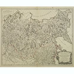
Estats du Grand duc de Moscovie ou de l'Empereur de la Russie Blanche.
Uncommon map of European Russia centered on Muscovy. Charming title cartouche in upper right corner.
- $300 / ≈ €254
Date: Amsterdam, ca 1749

Das Hertzogthum Braband. . .
Charming map of the Dutch and Belgium province of Brabant. With a fine cartouche.
Date: Leipzig, 1749
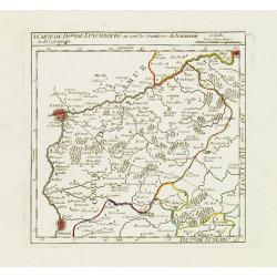
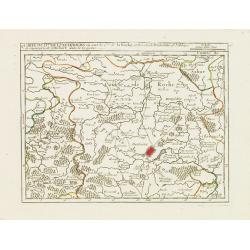
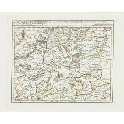
I. Carte du D.ché de Luxembourg ou sont les Frontieres du Namurois et du Lyegeois.
Charming small map representing part of the Walloon Region, delimited by the towns of Namur, Huy, Dinant and Ciney.From Atlas Portatif Universel, by Robert de Vaugondy. E...
Date: Paris, later than 1749
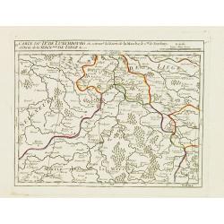
II. Carte du D.é de Luxembourg.. Seign.rie de Lyege &c.
Charming small map representing part of the Walloon Region, south to Liège. From Atlas Portatif Universel, by Robert de Vaugondy.Edited by : "Au dépôt de Géograp...
Date: Paris, later than 1749
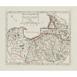
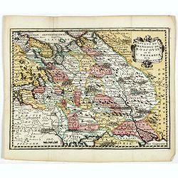
Royaume de Prusse et Prusse Rle. ou Polonoise.
On the left is Pomerania and the Desert of Waldow. At the top of the map is Memel and Samland. On the right side is the Biss River and Kautten. In the center of the map i...
- $125 / ≈ €106
Date: Paris, later than 1749
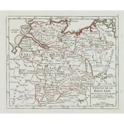
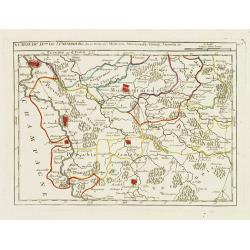
Cercle de la Basse Saxe, divisée par ses Principautés.
Small detailed map of the northern part of Germany. From Atlas Portatif Universel, by Robert de Vaugondy.Unrecorded state with erased date. Page 22 outside border top rig...
- $50 / ≈ €42
Date: Paris, later than 1749
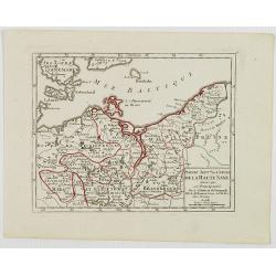
Partie Sept.le du Cercle de la Haute Saxe divisé par ses Principautés.
Small detailed map of the northeastern part of Germany, with Berlin at the bottom. Including part of Poland. From Atlas Portatif Universel, by Robert de Vaugondy.Unrecord...
- $75 / ≈ €64
Date: Paris, later than 1749
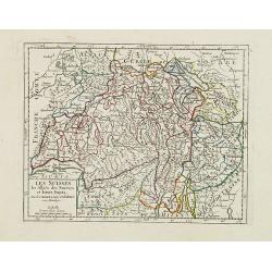
Les Suisses, les Alliés des Suisses et leurs Sujets.
Small detailed map of Switzerland. From Atlas Portatif Universel, by Robert de Vaugondy.Unrecorded state with erased date. Page 31 outside border top right. Mary Sponberg...
Date: Paris, later than 1749
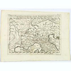
A Map of Gallia, Cisalpina, Liguria and the Neighbouring Countries.
A map of eastern France, Provence, northern Italy, then to Tuscany, whilst also showing northern Switzerland and Bavaria in Roman times. Showing Roman Provinces, a mileag...
Date: London, ca 1749
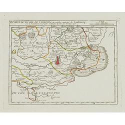
IV. Carte du Duché de Luxembourg où sont les Seign.ries de Lompré..
Charming small map representing part of Luxembourg, the southernmost province of Wallonia and of Belgium.From Atlas Portatif Universel, by Robert de Vaugondy. Edited by :...
Date: Paris, later than 1749

L'Arabie.
Small detailed map of the Arabian Peninsula. From Atlas Portatif Universel, by Robert de Vaugondy.Page 162 outside border top right.
Date: Paris, later than 1749
Partie Orientale de la Terre Ferme ou l'on trouve la Guiane.
Nice small map encompassing a large area between the Orinoco and the River Amazon.From Atlas Portatif Universel, by Robert de Vaugondy.Page 107 outside border top right. ...
- $75 / ≈ €64
Date: Paris, later than 1749
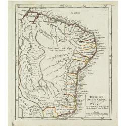
Terre de Sainte Croix, nommée à présent Bresil.
Detailed small map showing most part of the Brazilian seacoasts, from the mouth of the Amazon River as far as the island of Sao Sebastiao.From Atlas Portatif Universel, b...
- $75 / ≈ €64
Date: Paris, later than 1749
Partie Orientale de la Haute Guinée.
Nice small map centered on the Gulf of Guinea. Showing Sao Tomé and Principe. From Atlas Portatif Universel, by Robert de Vaugondy. "80" outside border top rig...
- $75 / ≈ €64
Date: Paris, later than 1749
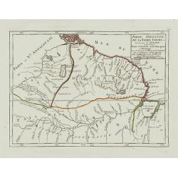
Nubie Abissinie et Cote d'Ajan.
Charming small map showing the Horn of Africa. Included are part of present-day Yemen and the coastline of Saudi Arabia along the Red Sea.From Atlas Portatif Universel, b...
- $100 / ≈ €85
Date: Paris, 1749
V. Carte du D.hé de Luxembourg.. dans le Lyegeois.
Charming small map representing part of Luxembourg, the southernmost province of Wallonia and of Belgium. Centered on Bastogne.From Atlas Portatif Universel, by Robert de...
Date: Paris, later than 1749
VII. Carte des Frontieres du Luxembourg.. Yvoix &c.
Detailed small map showing an area straddling the border between France and Belgium.From Atlas Portatif Universel, by Robert de Vaugondy. Edited by : "Au dépôt de ...
Date: Paris, later than 1749
IX. Carte du D.ché du Luxembourg.. Diekirch &c.
Charming small map representing the area between Luxembourg and Trier. From Atlas Portatif Universel, by Robert de Vaugondy.Edited by : "Au dépôt de Géographie, R...
Date: Paris, later than 1749
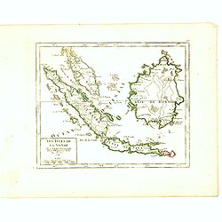
Les Isles de la Sonde Par le Sr. Robert de Vaugondy fils de Mr. Robert Geog. Ord du Roi avec Privilege 1749.
Small detailed map of of South East Asia, including Malaysian Peninsular with Singapore. From Atlas Portatif Universel, by Robert de Vaugondy.Page 170 outside border top...
Date: Paris, 1749
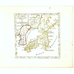
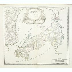
Le Japon Par le Sr. Robert de Vaugondy fils de Mr. Robert Geog. Ord du Roi avec Privilege 1749.
Small detailed map of Japan and Korea. From Atlas Portatif Universel, by Robert de Vaugondy.Page 168 outside border top right. First state. The map is of interest for the...
Date: Paris, 1749

Partie du Mexique ou de la Nouvelle Espagne Où se trouve l'Audience de Guatimala.
Nice small map of Central America, extending from the Yucatán Peninsula to Panama. From Atlas Portatif Universel, by Robert de Vaugondy.From Atlas Portatif Universel, by...
Date: Paris, later than 1749

Royaume de Bohéme, Marquisat de Moravie, et Silésie Autrichenne.
Small detailed map of today Czech Republic. From Atlas Portatif Universel, by Robert de Vaugondy.Unrecorded state with erased date. Page 32 outside border top right. Mary...
Date: Paris, later than 1749
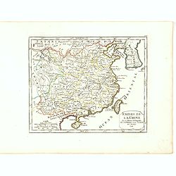
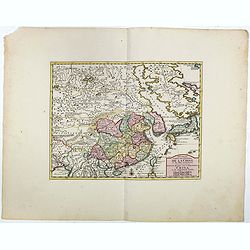
Empire de la Chine Par le Sr. Robert de Vaugondy fils de Mr. Robert Geog. Ord du Roi avec Privilege 1749.
Small detailed map of China, and Corea, including Taiwan. From Atlas Portatif Universel, by Robert de Vaugondy.Page 165 outside border top right. First and only state.The...
Date: Paris, 1749
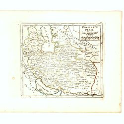
Royaume de Perse Par le Sr. Robert de Vaugondy fils de Mr. Robert Geog. Ord du Roi avec Privilege 1749.
Small detailed map of Persia. From Atlas Portatif Universel, by Robert de Vaugondy.Page 163 outside border top right. First and only state.
Date: Paris, 1749
X. Carte du D.ché de Luxembourg.. Jametz &c.
Nice small map encompassing the northwestern part of Lorraine. Showing Mouzon, Stenay, Montmedy..From Atlas Portatif Universel, by Robert de Vaugondy. Edited by : "A...
Date: Paris, later than 1749
![[IX.] Carte du Brabant ou sont les Mairies de Roo, de Nivelle, de Hulpen, et de Geneppe.](/uploads/cache/24689-250x250.jpg)
[IX.] Carte du Brabant ou sont les Mairies de Roo, de Nivelle, de Hulpen, et de Geneppe.
Nice small map straddling the Flemish and the Walloon regions. It shows Halle, Nivelles, La Hulpe, Overijse, Genappe, etc.From Atlas Portatif Universel, by Robert de Vaug...
Date: Paris, later than 1749
Carte de la Tartarie Occidentale.
Uncommon issue of this finely engraved map showing China's capital city of Peking inland from the Gulf of Lyau-tong. The map locates northeastern China to the border of R...
- $150 / ≈ €127
Date: Amsterdam, 1749
III. Carte du D.hé de Luxembourg.. Cronenburg &c.
Charming small map representing part of the Walloon Region, southeast to Limburg. From Atlas Portatif Universel, by Robert de Vaugondy.Edited by : "Au dépôt de Gé...
Date: Paris, later than 1749

Nieuwe kaart van het oostelykste deel van Holland. . .
Detailed map covering the area of Gouda, IJsselstein, s'Hertogenbosch, Zevenbergen, Dordrecht.
Date: Amsterdam, 1749
Milan. Ville forte, Capitale du Duché de même nom, l'une des plus grandes des des plus considérables de l'Italie.
A very decorative and extremely rare of Milan, including a numbered key ( 1-35 ) in lower part. Published by Jacques Chéreau, (1688 - 1776). Engraved by Aveline and fir...
- $3500 / ≈ €2968
Date: Paris, ca.1750
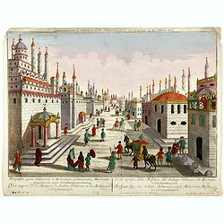
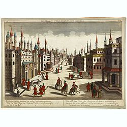
Prospectus, quem Solimanni et Mohameti. . . - Vue aupres de la Mosquee du Sultan Soliman, et de Mohamet . . .
Imaginary view inside Istanbul showing Sultan Soliman in his carriage , a so-called optical print.
Date: Augsburg 1750
Prospectus septem turrium in urbe Constantinopolitana / Vüe des sept Tours ou Prisons d'etat à Constantinople. . .
Imaginary view inside Istanbul showing the State prison, the seven towers to Constantinople, a so-called optical print.
Date: Augsburg 1750
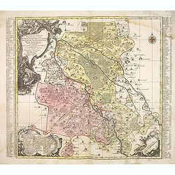
Electoratus saxonici praefecturae annaburgensis pretzschens torgaviensis schweinicensis. . .
Highly detailed map showing the regions of Annaburg, Pretzsch, Schweinitz in Sachsen-Anhalt, Torgau in Sachen and Mühlberg an der Elbe in Brandenburg. In the center of t...
Date: Augsburg, 1750

Nieuwe en zeer accuraate Zee-Caart van de Hollandse Wal strekkende van de Maas tot Texel opgenomen door Jan Rokusz Douw, , ,
A very fine and rare chart of the coast of Holland, Prepared by Jan Rokusz, Douw and Agge Roskam Kool.Embellished with a very decorative cartouche with a dedicational tex...
Date: Amsterdam, 1750
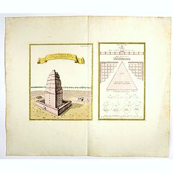
Totius Templi Beli et partis ubis Babylonicae prospectiva.
Two print on the same sheet, showing The Tower of Babe. The story of the city of Babel is recorded in Genesis 11:1–9. Everyone on earth once spoke the same language. As...
Date: Nuremberg, 1750

Vue de L'Hotel de Batavie. . .
A so-called optical print of Fatahillah Square in Jakarta, Indonesia, prepared for use in a light-box or an amusing light-show. This richly hand colored print is much per...
Date: Augsburg, 1750

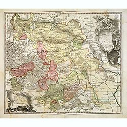
Dynastiae Comitat. Schoenburgici Penig, Remissa, Rochsburg, Wechselburg In Clientela Elect: Saxon Glaucha, Hartenstein, Lichtenststein, Walkenburg. . .
A very uncommon and superbly decorative map of Lower Saxony, the region southwest of Dresden. Including the towns of Rochlitz, Geringswalde, Mittweida, Frankenberg, Chemn...
Date: Augsburg, 1750
Principatus Halberstadiensis, abbat : Quedlinburgens cum Comitatu Wernigerodano, ad hodiernum verum statum ex acta prodiit ex officina geogr. . .
Detailed map showing principality Halberstadt, Abtei Quedlinburg and the county Wernigerode. Including the towns of Osterwieck, Stollberg, Aschersleben and Oschersleben.
Date: Augsburg, 1750
L'Empire du Japon divisé en sept principales parties. . .
Large map of Japan and Korea with a distinctively French style title cartouche containing two small landscapes.The map draws heavily on the previous work of Bellin, but i...
Date: Paris, 1750
Nouvelle Carte de L'Empire De La Chine et les Pais circonvoisins - Nieuwe Kaart van t Keizerryk China en de aangrensende Landen.
Finely engraved map of China and Korea, with titles in both French and Dutch.The map extends west to the Gobi Desert and Tibet and shows Macao and Canton, among other cit...
- $500 / ≈ €424
Date: Amsterdam, 1750

1. Seigneure Delassa tirés de Grueber. 2. Trophée à l'honneur du Grand Lama. (Tibet).
Fanciful European depiction of people from Tibet and Lhassa. A somewhat larger image appeared in "Abbe A.F. Prévost, Histoire Generale des Voyages".
Date: Paris, ca. 1750
![[Set of 3 optical prints] Vue du Pallais du l'Empereur de Perse avec la Mosquée, ou Eglise a Ispahan.](/uploads/cache/49123-250x250.jpg)
[Set of 3 optical prints] Vue du Pallais du l'Empereur de Perse avec la Mosquée, ou Eglise a Ispahan.
An optical print of the court of the Persian Emperor. Engraved by F.X. Habermann (1721-1796). The Academie Imperiale was a well-known publisher of optical prints establis...
Date: Augsburg, 1750

Les Villes forts et châteaux de Malte capitale de l'isle de ce nom. Dessignée sur le lieu par un Ingr du roy.
A very decorative and extremely rare town-view of Valetta, including a numbered legend in lower part. Published by Jacques Chereau, (1688 - 1776). Engraved by Aveline and...
Date: Paris, ca.1750
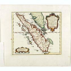
Carte de L'Isle de Sumatra Dressee sur les Journaux des Navigateurs . . .
Detailed map of Sumatra and Malacca, centered on Singapore and including the southern portion of the Malaysian peninsula. With "Detroit de Sincapour" and severa...
Date: Paris, ca. 1750

Antoine François Prevost . . .
Portrait of Antoine François Prevost (1697 – 1763), engraved by Ficquet after a design of F.Schmidt.Prevost was born at Hesdin, Artois, and first appears with the full...
- $90 / ≈ €76
Date: Paris, ca. 1750

Vue du village de Maarsen en Hollande.
Showing the river Vecht at the town of Maarsen. Published by Jacques Chereau, who was a well-known publisher of optical prints, established in rue St. Jacques in Paris. I...
Date: Paris, ca. 1750
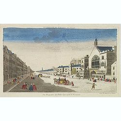
Vue perspective du palais episcopal de Westminster.
So-called optical print illustrating a perspective view of the old Palace of Westminster where the Lords and Commons met and the square facing it.. Published by Jacques C...
- $150 / ≈ €127
Date: Paris, ca. 1750
Nouvelle Carte de L'Empire De La Chine et les Pais circonvoisins - Nieuwe Kaart van t Keizerryk China en de aangrensende Landen.
Finely engraved map of China and Korea, with titles in both French and Dutch.The map extends west to the Gobi Desert and Tibet and shows Macao and Canton, among other cit...
Date: Amsterdam, 1750
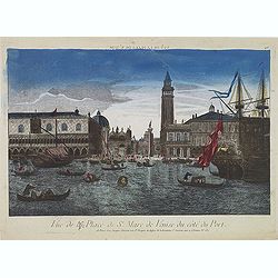
Vue de la Place de St Marc de Venise du côté du port.
Optical print showing the Doge's Palace (Palazzo Ducale), San Marco Square, and Saint Mark's Basilica (Basilica di San Marco in Venice, as seen from the waterside. The im...
Date: Paris, ca. 1750
![[OSTENDE] A new and exact Plan of the city and port of Ostend.](/uploads/cache/39849-250x250.jpg)
[OSTENDE] A new and exact Plan of the city and port of Ostend.
Nice plan of the city of Ostend and Fort Philippe, engraved by R. Benning. In upper left corner "A map of part of Flanders shewing the country and sands about Ostend...
- $300 / ≈ €254
Date: Paris, ca. 1750
![La ville et citadelle d'Anvers. [Antwerp]](/uploads/cache/39843-250x250.jpg)
La ville et citadelle d'Anvers. [Antwerp]
A town-plan of the fortified enclosure of Antwerp with its citadel, showing the extensions made between 1201 and 1701, when the fortifications were enlarged by Philippe V...
- $225 / ≈ €191
Date: Paris, ca. 1750

Vue perspective edu fauxbourg et du port de Scheveningue a une lieue de la Haye, en Hollande.
Optical print showing the village and harbor of Scheveningen with the church at the right, in the background the North Sea. In the background, the summer residence Nieuw ...
Date: Paris, ca. 1750
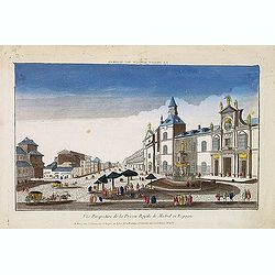
Vue perspective de la prison royale de Madrid en Espagne . . .
So-called optical print of the Royal Prison, now the Ministry of Foreign Affairs in Madrid. Published by Jacques Chereau, who was a well-known publisher of optical prints...
- $200 / ≈ €170
Date: Paris, ca. 1750
Partie Orientale De L'Empire De Russie En Asie, ou trouvent les Provinces de Jakuckskoy, Kransnojarskoy, Selinginskoy, Ilimskoy, Krasnojarskoy, Narimskoy, Jenisseiskoy, Mangajeiskoy, & c. et les Confins de la Tatarie Chinoise. . . .1750
Map of the Northeastern portion of Asia, including Russia, China, the Gobi Desert, etc..
- $250 / ≈ €212
Date: Paris, 1750
![Plan de Mons ville capitale du comté de Haynaut. [MONS]](/uploads/cache/39799-250x250.jpg)
Plan de Mons ville capitale du comté de Haynaut. [MONS]
Charming little plan of the city of Mons in Belgium, engraved by Inselin, with a lettered key (A-V) in lower right corner.
Date: Paris, 1750

Arc de Triomphe ou se passe la proscription d'Octave et d'Antoine.
J. Chereau was a publisher of optical prints, established in Paris, rue St.Jacques.In the eighteenth and nineteenth centuries, there were many popular specialty establish...
- $200 / ≈ €170
Date: Paris, ca. 1750
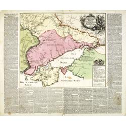
Charte der Kriegs Operationen am Donn u: Dnieper Ihro Russisch Kayserl Majestaet Glorieusen Armeen A: 1736.
Very rare separately published map of the southern part of Ukraine, with an explanatory key A-N in the lower right. The map is surrounded by letterpress German text givin...
Date: Augsburg, 1750
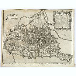
Ghent a large City and Castle in Flanders. . .
A very fine bird's-eye plan of the city and fortifications of Ghent and the surrounding countryside in Belgium. A decorative cartouche encloses a detailed key to the map ...
- $100 / ≈ €85
Date: London, ca 1750
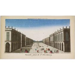
Nouvelle place de St. Pétersbourg.
Showing a square at 18th century Saint Petersburg. J. Chereau was a publisher of optical prints, established in Paris, rue St.Jacques.In the eighteenth and nineteenth ce...
- $200 / ≈ €170
Date: Paris, ca. 1750
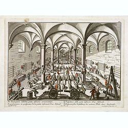
Per telecopium exhibitio partis inferioris armamentarii. / Representation en perspective de la partie inferieure d'un arsenal. . .
RARE. Engraved optical print by Georg Balthasar Probst of a arsenal.
Date: Augsburg, 1750

Transisalania vulgo Over-Yssel auct. N. ten Have. . .
Map of the central part of the Netherlands, prepared by N. ten Have with a decorative cartouche lower left.Joachim Ottens (1663 - 1719) and his sons Renier and Joshua wer...
Date: Amsterdam, ca. 1750