Browse Listings
![Ulma Folio CXCI [With view of Ulm.]](/uploads/cache/29713-250x250.jpg)
Ulma Folio CXCI [With view of Ulm.]
Double-page panoramic view of Ulm.An imaginary view, however, is the earliest obtainable view of this period.Two pages from the richest illustrated Incunabel, the famou...
Date: Nuremberg, 12 July 1493
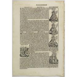
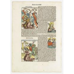
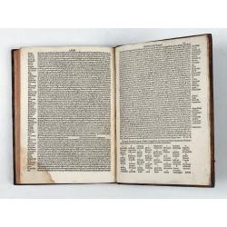
Text page with Kings, Queens, Saints and Popes. Sexta Etas Mundi. Folium. CXVI.
Recto verso text page with woodcuts of Kings, Queens, Saints (St.Cecilia), Popes and historical personalities. Page from the richest illustrated Incunable, the famous ...
Date: Nuremberg, 12 July 1493
![Bamberga. Folium CLXXV [Bamberg]](/uploads/cache/47606-250x250.jpg)
Bamberga. Folium CLXXV [Bamberg]
Double page panoramic view of Bamberg. One of the earliest obtainable views of this period.Two pages from the richest illustrated Incunable, the famous Nuremberg Chronic...
Date: Nuremberg, 12 July 1493

Secunda etas mundi. Folium XIII.
Schedel's world map was based on the cartographic system of Claudius Ptolemy, the great second-century AD geographer whose scholarship formed the foundation for map produ...
Date: Nuremberg, 12 July 1493
![Madeburga [ Maagdenburg Folio CLXXX ]](/uploads/cache/12338-250x250.jpg)
Madeburga [ Maagdenburg Folio CLXXX ]
Double-page panoramic view of Magdeburg. A imaginary view, however the earliest obtainable view of this period.Two page from the richest illustrated Incunable, the famous...
Date: Nuremberg, 12 July 1493

(EUROPE).
The map of Europe has been identified as the work of Hieronimus Münzer (1437-1508), a Nuremberg physician who supplied the geographical contents of the chronicle. The Eu...
Date: Nuremberg, 1493
![Sexta Etas Mundi. Ratisbonna. [Ratisbonne]](/uploads/cache/13549-250x250.jpg)
Sexta Etas Mundi. Ratisbonna. [Ratisbonne]
A very fine presentation of the city of Ratisbon, in Germany, centered on the cathedral (Dim. : 191 mm W : 525 mm).Overleaf a very nice view of Vienna, with two swans on ...
Date: Nuremberg, 12 July 1493
![Venecie. [Venice] Foliu XLIIII.](/uploads/cache/49420-250x250.jpg)
Venecie. [Venice] Foliu XLIIII.
A very fine panoramic view of Venice (192x525mm.) Verso a view of Padua. Schedel's view of Venice is one of the earliest obtainable views of the city. The view is based o...
Date: Nuremberg, 12 July 1493

Prima Etas Mundi. VI
A very fine presentation of Eve, being created by God from Adam’s side.Page from the richest illustrated Incunable, the famous: Nuremberg Chronicle, published the year ...
- $400 / ≈ €349
Date: Nuremberg, 12 July 1493
![Quarta Etas Mndi. Carvilium / Aquileya. [Carovilli and Aquileia]](/uploads/cache/13525-250x250.jpg)
Quarta Etas Mndi. Carvilium / Aquileya. [Carovilli and Aquileia]
A lovely presentation of Carovilli, in the province of Cremona. Recto, a view of the town of Aquileya in Italy, centered on the castle and the high walls. Aquileia is an ...
Date: Nuremberg, 12 July 1493
Prima Etas Mundi. IX
A very fine presentation of Eve nursing Kain and Abel. Adam is working (255x220 cm). VERSO a genealogy of Adam.Page from the richest illustrated Incunabel, the famous: Li...
- $600 / ≈ €523
Date: Nuremberg, 12 July 1493
Sexta Etas Mudi. Lucas Evagelista. Folium CVIII.
A very nice presentation of Lucas the Evangelist (100x80mm.) and the representation of Maria Magdalena held by angels 210x135mm.).VERSO : Showing the line of the popes Cl...
- $100 / ≈ €87
Date: Nuremberg, 12 July 1493
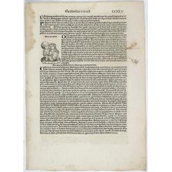
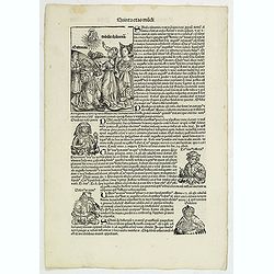
![[Text page with Kings and Popes, folio CXLVIII ].](/uploads/cache/47603-250x250.jpg)
[Text page with Kings and Popes, folio CXLVIII ].
Text page with woodcuts of Kings and on verso woodcuts of Popes including Pope Gregorius. Page from the richest illustrated Incunable, the famous: Nuremberg Chronicle, p...
- $70 / ≈ €61
Date: Nuremberg, 12 July 1493

(EUROPE).
A woodcut colored map of northern and central Europe. The first modern map of the area. Second printed map of the North, after the woodcut map published in the 'Ulm' Ptol...
Date: Nuremberg, 1493
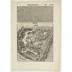
Sexta Etas Mudi. (With view of Sabatz.) Folio CCLIII
A imaginary view of Sabatz, Turkey: however the earliest obtainable view of this period.Further including presentations of the popes Sixtus IV and Innocentius VIII. Pag...
- $200 / ≈ €174
Date: Nuremberg, 12 July 1493
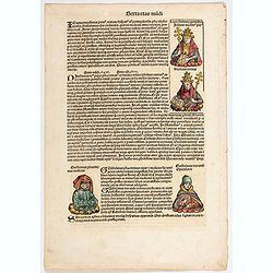
Quinta Etas Mundi. Folium. XCIIII [Portrait of Strabo]
The Latin text page is illustrated with a depictions of Kings, Noble men and women and scientists, like Strabo, a historian, geographer and philosopher. Mother Mary and Z...
- $50 / ≈ €44
Date: Nuremberg, 12 July 1493
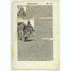
Sexta Etas Mundi. Folium. CXXV
Latin text page with woodcuts on recto and verso of Saints, Kings, and Queens. Including Lucia (Lucia Martyr) is represented with a nimbus and crown of martyrdom. A sword...
- $50 / ≈ €44
Date: Nuremberg, 12 July 1493
Quinta Etas Mundi. Folium. XCIIII [Portrait of Strabo]
The Latin text page is illustrated with a depictions of Kings, Noble men and women and scientists, like Strabo, a historian, geographer and philosopher. Mother Mary and Z...
- $25 / ≈ €22
Date: Nuremberg, 12 July 1493
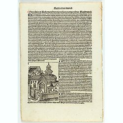
![Sexta Etas Mundi. Foliu CXXXV [Text page with S. Hieronymus, the patron of theological learning].](/uploads/cache/25763-250x250.jpg)
Sexta Etas Mundi. Foliu CXXXV [Text page with S. Hieronymus, the patron of theological learning].
Text page with woodcuts of the following saints: S. Hieronymus, the patron of theological learning (100x80mm.)VERSO is printed with text and images of Popes and Kings.Pag...
Date: Nuremberg, 12 July 1493
![Madeburga [ Maagdenburg Folio CLXXX ]](/uploads/cache/47601-250x250.jpg)
Madeburga [ Maagdenburg Folio CLXXX ]
Double page panoramic view of Magdeburg. A imaginary view, however the earliest obtainable view of this period.Two page from the richest illustrated Incunable, the famous...
Date: Nuremberg, 12 July 1493
Sexta etas Mundi. Folium. CCXLV
The Latin text page is illustrated with a depiction of two lovers happened to have lived in Italy: a knight named Eurialus, who was the personal attendant of Emperor Sigi...
- $75 / ≈ €65
Date: Nuremberg, 12 July 1493
![[Text page with Kings and historical personalities.] Quita etas mundi. Foliu. LXXXIII](/uploads/cache/26874-250x250.jpg)
[Text page with Kings and historical personalities.] Quita etas mundi. Foliu. LXXXIII
Text page with woodcuts of Kings and historical personalities.Page from the richest illustrated Incunable, the famous: Nuremberg Chronicle, published the year that Columb...
Date: Nuremberg, 12 July 1493
PATAVIA (Passau, Germ)
From the first Latin text edition, 1493. The view of PATAVIA (nowadays the city of Passau, Southern Germany) was part of the Liber Chronicarum cum figuris et ymagibus ...
Date: Nuremberg, Germany, 1493
Sexta Etas Mudi. Symon Apostolus.. Folio CVII.
A very nice presentation of the martyr of Simon, sawn in half at Suanir, and Mathias stoned to death at Colchis in 80 AD. Overleaf, it shows the martyr of Matthew and Jud...
Date: Nuremberg, 12 July 1493
![[ Secunda etas mundi. Foliu XVIII ].](/uploads/cache/26866-250x250.jpg)
[ Secunda etas mundi. Foliu XVIII ].
Text in Latin, each paragraph separated by the triumphant cross with orb representing Christ's reign over the world (it is often shown atop Christ's scepter in Christian ...
Date: Nuremberg, 12 July 1493
![Tertia Etas Mundi. Folium. CI [Woodcut of Jesus and his apostles]](/uploads/cache/48519-250x250.jpg)
Tertia Etas Mundi. Folium. CI [Woodcut of Jesus and his apostles]
The Latin text page is illustrated with a depictions of Kings, Noble men and women and scientists. VERSO : A full page woodcut showing Jesus and his apostles.(360x221mm.)...
Date: Nuremberg, 12 July 1493
![Carthage, etc. [Foliu XL ]](/uploads/cache/26122-250x250.jpg)
Carthage, etc. [Foliu XL ]
VERSO: Portraits of scholars, and an imaginary view on Carthage in Tunisia (12x17cm.) Page from the famous Liber chronicarum of Hartmann-Schedel 1493, the first and Latin...
Date: Nuremberg 12 July 1493

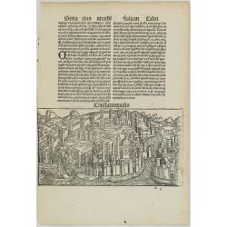
Constantinopolis.
A spectacular woodcut panorama of the ancient city of Constantinople, proporting to show the pre-Turk city (for example naming St Sophia). (235x522mm).One of the earliest...
Date: Nuremberg, 12 July 1493
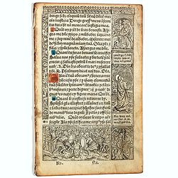
![[Text page with Saint Appolonia, the patron saint of dentistry. - Sexta Etas Mundi. Folium. CXX ].](/uploads/cache/26526-250x250.jpg)
[Text page with Saint Appolonia, the patron saint of dentistry. - Sexta Etas Mundi. Folium. CXX ].
Text page with woodcuts of Abdon & Senen, Agatha, Appolonia, Serapion, Meniacus, Victoria. With a woodcut of Appolonia, the patron saint of dentistry. Because of the ...
Date: Nuremberg, 12 July 1493
Quinta Etas Mundi. Folium.XCIII.
The Latin text page is illustrated with depictions of Caius Julius Caesar, Octavian (Octavianus) Augustus and Mark Antony (Marcus Antonius). VERSO : A wonderful woodcut (...
Date: Nuremberg, 12 July 1493
Terta Etas Mundi. Folio CCXVI
Two pages from the richest illustrated Incurable, the famous: Nuremberg Chronicle , published the year that Columbus returned to Europe after discovering America.The wood...
- $100 / ≈ €87
Date: Nuremberg, 12 July 1493
Quinta Etas Mundi. Folium. LXVI. (Visionary Temple of Ezekiel.)
The Latin text page is illustrated with recto and verso depictions of the visionary Temple of Ezekiel. Kings.Page from the richest illustrated Incunable, the famous: Chro...
Date: Nuremberg, 12 July 1493
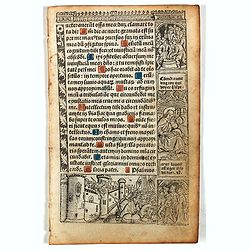
![[Page with imaginary towns in Hungary. ] CCLXVIII](/uploads/cache/26932-250x250.jpg)
[Page with imaginary towns in Hungary. ] CCLXVIII
Page with imaginary towns in Hungary (230x225mm.) This leaf is from an edition of Hartmann Schedel's Liber chronicarum or Nuremberg Chronicle. The Chronicle was published...
Date: Nuremberg, 1493
Sexta etas muidi Fo CCV.
The Latin text page is illustrating Baldwin (Baldvinus), the fourth of this name, seventh king of Jerusalem, and son of the aforesaid Amalric, reigned six years after his...
- $75 / ≈ €65
Date: Nuremberg, 12 July 1493
Sexta etas mudi CCXXXIX.
The Latin text page is describing the crusade against the Bohemian heretics in the time of emperor Sigismund Nuremberg Chronicle, published the year that Columbus returne...
Date: Nuremberg, 12 July 1493
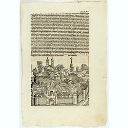
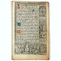
CCLXXV.
The Latin text page is illustrated with an imaginary view of a town in Macedonia (195 x 225mm.) The Nuremberg Chronicle, published the year that Columbus returned to Euro...
Date: Nuremberg, 12 July 1493
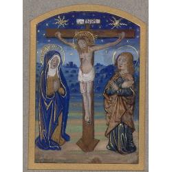
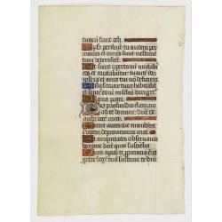
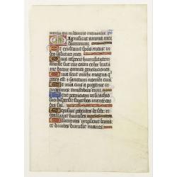
Miniature of The Crucifixion of Christ.
Page fragment from a Book of Hours with a miniature of the Cruxifiction with Saint Mary and Mary Magdalene in prayer in front of Jesus hung on the cross. This miniature c...
Date: Paris, 1492 - 1494
Constatinopolis.
Panoramic town-view of Constantinople (Istanbul). Woodcut published in the so-called pirate edition of the "small Schedel" in Augsburg, 1497, Latin edition. Ori...
Date: Augsburg, Johann Schönsperger. 1497
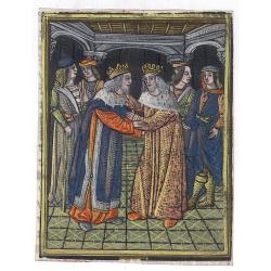
(Fragment of a text leaf from Universal Chronicle)
Fragment of a text leaf, showing a miniature depicting two Kings who are greeting each other surrounded by their knights. The metal cut has contemporary hand coloring and...
Date: Paris, c.1490-1500
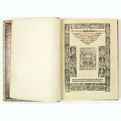
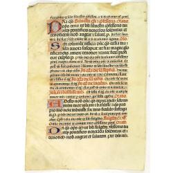
Manuscript leaf on vellum written in a late gothic hand.
VERSO: One 2-line initial P in burnished gold on a red and blue ground and 2 line-fillers on a red and blue ground.RECTO: 17 Lines of text, intils filled in with yellow.
Date: France or Flanders, c.1500
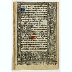
Leaf on vellum from a printed Book of Hours.
21 Lines of printed text, surrounded by renaissance borders decorated with putti, flowers and Middle French script around the illustrations.Interesting are the 6 panels w...
- $150 / ≈ €131
Date: Paris, Philippe Pigouchet for Simon Vostre, ca. 1502
Strabo de situ orbis.
Rare post-incunable 1502 sixth edition of Strabo’s Geographica, translated from Ancient Greek to Latin as De Situ Orbis by Guarino da Verona and Gregorio Tifernate.The ...
Date: Venice, Bartolomeo de Zanis,14th day of January 1502
Leaf on vellum from a printed Book of Hours.
24 lines of printed text, surrounded by renaissance borders decorated with scenes and figures.The firm of Thielman Kerver is best known for its lovely printed Books of Ho...
- $125 / ≈ €109
Date: Paris, Philippe Pigouchet for Simon Vostre, ca. 1502
Leaf on vellum from a printed Book of Hours.
24 lines of printed text, surrounded by renaissance borders decorated with scenes and figures.The firm of Thielman Kerver is best known for its lovely printed Books of Ho...
- $125 / ≈ €109
Date: Paris, Philippe Pigouchet for Simon Vostre, ca. 1502
Leaf on vellum from a printed Book of Hours.
24 lines of printed text, surrounded by Renaissance borders decorated with scenes and figures.The firm of Thielman Kerver is best known for its lovely printed Books of Ho...
- $125 / ≈ €109
Date: Paris, Philippe Pigouchet for Simon Vostre, ca. 1502
A printed leaf from a Book of Hours.
RECTO: Two 2-line and two 1-line initials in liquid gold on colored grounds. Miniature with Saint Anne. Decorative panel border in he right and lower margins.VERSO: One 2...
Date: Paris, G. Hardouin, 1512
Strabonis illustrissimi scriptoris Geographia decem et septem libros continens.
First edition was published in Paris in the sixteenth century and the first with the preface by Thibaud Pigenat. Translation from Greek into Latin by Gregorio Tifernate a...
- $5000 / ≈ €4359
Date: Paris, Hémon Le Fèvre, 1512

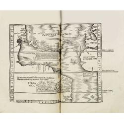
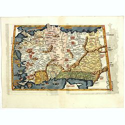
Tabula Prima Africa.
The map apart from depicting Morocco also shows southern Spain and the Balearic Islands. In north Africa the map extends eastwards toward modern day Algeria and to the we...
Date: Strasbourg, 1513
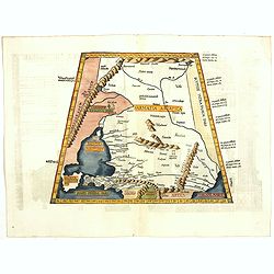
Octava Asie Tabula (The Silk Road Area.)
Woodblock printed large-format map showing Northern India with Central Asia including the Himalayas and China. From the 1513 edition of Waldseemüller's Geographia.In the...
Date: Strasburg, 1513
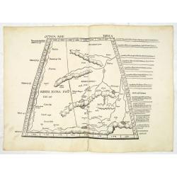
Septima Asie Tabula (Central Asia.)
A woodblock-printed large-format Ptolemaic map showing the region east of the Caspian Sea is labeled SOGDIANA. Sogdia or Sogdiana was an ancient Iranian civilization betw...
Date: Strasburg, 1513
Secunda Asiae Tabula (Ukraine and Russia)
Woodblock printed a large-format Ptolemaic map showing Russia, Ukraine, and the Black Sea region. From the 1513 edition of Waldseemüller's Geographia.One of the earliest...
Date: Strasburg, 1513

Tabula Secunda Europe (Spain & Portugal)
Wood block printed large-format Ptolemaic map of the Iberian Peninsula from the 1513 edition of Waldseemüller's Geographia.This Ptolemaic map comes from the first so cal...
Date: Strasburg, 1513
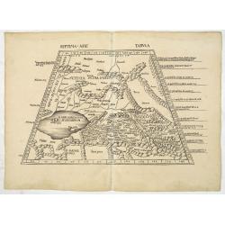
![Septima Asie Tabvla. |Walsseemüller's map of Central Asia and the Silk Road]](/uploads/cache/62137-250x250.jpg)
Septima Asie Tabvla. |Walsseemüller's map of Central Asia and the Silk Road]
Trapezoidal woodcut map showing the area east of the Sarygamysh Lake, about midway between the Caspian Sea and the (former) Aral Sea. It is one of the earliest obtainabl...
Date: Strasburg, J. Schott, 1513

Quinta Asie Tabvla.
A woodblock map of ancient Median and Persian lands in modern-day Iran is from Martin Waldseemüller's 1513 edition of Ptolemy, a landmark work that contributed to major ...
Date: Strasbourg, J. Schott, 1513
Leaf on vellum from a manuscript Book of Hours.
VERSO: one 2-line illuminated initial showing a bird in fine detail in liquid gold on colored ground, seven 1-line initials and line-fillers in same.RECTO: Seven 1-line i...
Date: France, c. 1520

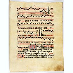
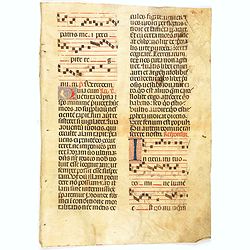
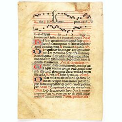
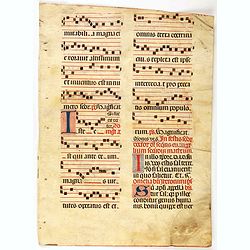
Leaf on vellum from a antiphonary.
A leaf from a Medieval Antiphonal or Choir Missal for Spanish use, in Latin on extremely heavy vellum. Justification: 360x246mm. Text is in Spanish rounded gothic hand (R...
Date: Sevilla, ca.1520
Leaf on vellum from a manuscript Book of Hours.
RECTO: One 2-lines initial decorated with flower in liquid gold on colored grounds and six 1-line initials in liquid gold on colored grounds and five line-fillers in same...
Date: France, c. 1520
Leaf on vellum from a manuscript Book of Hours.
RECTO: One 2-lines initial decorated with flower in liquid gold on colored grounds and six 1-line initials in liquid gold on colored grounds and five line-fillers in same...
Date: France, c. 1520
Leaf on vellum from a antiphonary.
A leaf from a Medieval Antiphonal or Choir Missal for Spanish use, in Latin on extremely heavy vellum. Justification: 360x246mm. Text is in Spanish rounded gothic hand (R...
Date: Sevilla, ca.1520
Leaf on vellum from a antiphonary.
A leaf from a Medieval Antiphonal or Choir Missal for Spanish use, in Latin on extremely heavy vellum. Justification: 360x246mm. Text is in Spanish rounded gothic hand (R...
Date: Sevilla, ca.1520
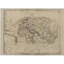
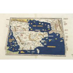
Orbis Typus Universalis Iuxta Hydrographorum Traditionem.
Waldseemüller's monumental modern map of the world from the celebrated Strassbourg edition of Ptolemy's Geography, the most important cartographer of the early sixteenth...
Date: Strasburg, 1513 / 1520
Leaf on vellum from a antiphonary.
A leaf from a Medieval Antiphonal or Choir Missal for Spanish use, in Latin on an extremely heavy vellum. Justification: 360x246mm. Text is in Spanish rounded gothic hand...
- $250 / ≈ €218
Date: Sevilla, ca.1520
Leaf on vellum from a antiphonary.
A leaf from a Medieval Antiphonal or Choir Missal for Spanish use, in Latin on extremely heavy vellum. Justification: 360x246mm. Text is in Spanish rounded gothic hand (R...
- $250 / ≈ €218
Date: Sevilla, ca.1520
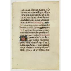
Leaf on vellum from a antiphonary.
A leaf from a Medieval Antiphonal or Choir Missal for Spanish use, in Latin on extremely heavy vellum. Justification: 360x246mm. Text is in Spanish rounded Gothic hand (R...
Date: Sevilla, ca.1520

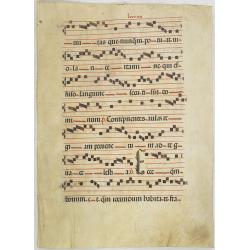
Leaf on vellum from a antiphonary.
A leaf from a Medieval Antiphonal or Choir Missal for Spanish use, in Latin on extremely heavy vellum. Justification: 360x246mm. Text is in Spanish rounded gothic hand (R...
Date: Sevilla, ca.1520
Leaf on vellum from a manuscript Book of Hours.
RECTO: One 2-line initials in liquid gold on colored grounds.VERSO: 17 lines of text in Latin.
- $150 / ≈ €131
Date: France, 1500-1520
Leaf on vellum from a antiphonary.
A leaf from a Medieval Antiphonal or Choir Missal for Spanish use, in Latin on extremely heavy vellum. Justification: 370x250 mm. Text is in Spanish rounded gothic hand (...
Date: Sevilla, ca.1520
![Claudii Ptolemaei Alexandrini mathematicor[um] ...Octo libri Geographie. . .](/uploads/cache/62656-250x250.jpg)
Claudii Ptolemaei Alexandrini mathematicor[um] ...Octo libri Geographie. . .
Third edition of "Géographie" by Ptolemy and published in Strasbourg. Illustrated with 50 maps engraved in wood. One of the more important maps shows the earli...
Date: Strasbourg, J. Grüninger, 1522
Claudii Ptolemaei geographicae enarrationis libri octo Bilibaldo Pirckeym hero interprete Annotationes Ioannis de Regio Monte in errores commissos a Iacobo Angelo in translatione sua.
This is a rare and interesting edition of Ptolemy's geography translated by Bilibaldo Pirckheym, accompanied by Regiomantus's annotations, and said to have been edited by...
- $59000 / ≈ €51431
Date: Strassburg, Johann Grüninger, Johann Koberger, 1525
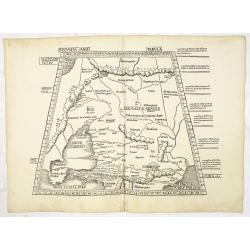
![Tabula III Asiae. [Caucasus and Armenia.]](/uploads/cache/47571-250x250.jpg)
Tabula III Asiae. [Caucasus and Armenia.]
Ptolemaic map of the region south of the Caucasus Mountains and between the Caspian Sea as far south as the headwaters of the Tigris River in the south and the Black Sea,...
- $750 / ≈ €654
Date: Lyons, M. Servetus, 1525
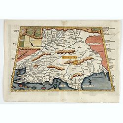
Tabula Sexta Asia (Arabian Peninsula)
This is a very desirable early Ptolemaic woodblock map of the Arabian Peninsula, here called Arabia Felix. The map is presented on a trapezoidal projection with paralle...
Date: Strassburg, 1525
Tabula X. Asiae hae sunt e cognitis totius orbis.
This is the earliest printed representation of India west of the Ganges River in Ptolemy's time. It is an essential map of southwestern Asia, including Persia, Afghanista...
Date: Lyons, M. Servetus, 1525
Leaf on vellum from a manuscript Book of Hours.
RECTO: One 2-lines initial decorated with flower in liquid gold on colored grounds and six 1-line initials in liquid gold on colored grounds and five line-fillers in same...
Date: France, ca. 1530
Leaf on vellum from a manuscript Book of Hours.
RECTO: One 2-lines initial decorated with flower in liquid gold on colored grounds and seven 1-line initials in liquid gold on colored grounds and six line-fillers in sam...
Date: France, ca.1530
Tabula I Asiae.
Ptolemaic map of Turkey.From Lorenz Fries' edition of Ptolemy's Geographia, largely based on the 1513 map by Waldseemuller. "The elaborate Renaissance woodcut panels...
- $750 / ≈ €654
Date: Vienna, 1490, 1535
![.Taprobana Ins. Tabula XII Asiae. [Sri Lanka.]](/uploads/cache/27928-250x250.jpg)
.Taprobana Ins. Tabula XII Asiae. [Sri Lanka.]
Ptolemy's mythical island of Taprobana originally became associated with Sri Lanka although it was sometimes confused with Sumatra. Taprobana, as it was called on most ea...
Date: Lyons, M. Servetus, 1535
![.Tabula III Asiae. [Caucasus and Armenia.]](/uploads/cache/27894-250x250.jpg)
.Tabula III Asiae. [Caucasus and Armenia.]
Ptolemaic map of the region south of the Caucasus Mountains and between the Caspian Sea as far south as the headwaters of the Tigris River in the south and the Black Sea,...
Date: Lyons, M. Servetus, 1535
![Tabula IIII Aphricae. [with Prester John]](/uploads/cache/42945-250x250.jpg)
Tabula IIII Aphricae. [with Prester John]
Early Ptolemaic woodcut map of the regions of Africa that were known to the ancients. The twin lake sources of the Nile are located near the Mons Lune (Mountains of the M...
- $950 / ≈ €828
Date: Vienna, 1522- 1535
Tabula II Asiae.
A striking example of this wood-cut map depicts north of the Black Sea and west of the Caspian Sea (Ukraine, Russia, Georgia and Armenia). Ptolemy collected his data arou...
- $550 / ≈ €479
Date: Lyons, 1535

.Tabu nova partis Aphri.
This is Laurent Fries' 1535 edition of the earliest acquirable modern mapping of Africa north of the Equator.Based on Waldseemüller's map. The maps show Northern Africa ...
Date: Lyons, M. Servetus, 1535