
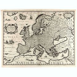
(EUROPE).
A woodcut colored map of northern and central Europe. The first modern map of the area. Second printed map of the North, after the woodcut map published in the 'Ulm' Ptol...
Date: Nuremberg, 1493

(EUROPE).
The map of Europe has been identified as the work of Hieronimus Münzer (1437-1508), a Nuremberg physician who supplied the geographical contents of the chronicle. The Eu...
Date: Nuremberg, 1493
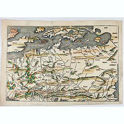
No title: Scandinavia/ Central Europe/ British Isles.
Map of Northern Europe from Nuremberg Chronicle . German text on verso. Printed by Anton Koberger. The map has been identified as the work of Hieronimus Münzer (1437-150...
Date: Nuremberg, 12 July 1493

I Europa / Das dritteil der Welt.
Very early wood cut printed map of Europe with South to the top. In the lower-left corner we see Poland, Livonia and parts of England and Ireland in the lower right corne...
Date: Zurich, Christoffel Froschover, 1548,1552-1566

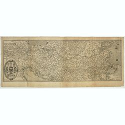
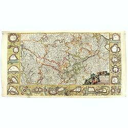
( II Germania) / Tütschland.
Very early wood cut printed map of Germany, Poland, The Low Countries, Alsace and part Europe with of Switzerland, Croatia. Originally engraved in 1548. Included in "...
Date: Zurich, Christoffel Froschover, 1548,1552-1566

Universe Europae Maritime Eiusque Navigationis Descriptio. Generale Pascaerte van Europa . . .
This general chart of north-western Europe and the surrounding coastal waters is from the rare pilot-guide De Spiegel der Zeevaerdt , printed by Christopher Plantin in Le...
Date: Leyden, 1584
Nova exactissimaque descriptio Danubii.
Rare loose impression of de Jode's map of the Danube with the surrounding countries with de Jode's imprint replaced by Theodor Galle's one. Without letterpress text on ve...
- $4000 / ≈ €3491
Date: Antwerp, 1600
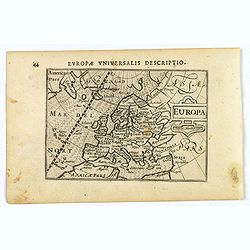
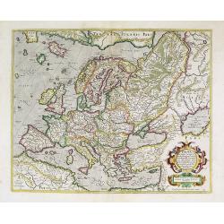
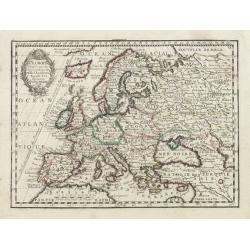
Europa.
A lovely miniature map of the continent of Europe, published by Petrus Bertius, in Amsterdam at the beginning of the seventeenth century.Engraved by J. Hondius, it has a ...
Date: Amsterdam, 1606
Europa.
The rare Samuel Purchas' edition of the Mercator/Hondius Atlas Minor atlas map. Early map of Europe published in his famous collection of voyages His Pilgrimes . With des...
- $150 / ≈ €131
Date: London, 1625
![[No title] Tabla de la Europa. . . / Italie.](/uploads/cache/29264-250x250.jpg)
[No title] Tabla de la Europa. . . / Italie.
Page from a Mercator Atlas with letter press in Spanish illustrated with two maps. Recto a map of Europe (109x16mm.) and on verso a map of northern Italy (90x150mm).
- $230 / ≈ €201
Date: Amsterdam, c.1625
Carte de L'Europe, corrigée et augmentée desus toutes les autres . . .
Rare map of Europe, dated 1627. First state, issued by Melchior Tavernier. Most probably engraved by Cornelis Danckerts (the elder), a highly skilled engraver. Most proba...
Date: Paris, 1627

Europa, ad magnae Europae Gerardi Mercatoris. . .
General map of Europe, as well as Americae Pars, Greenland, Iceland, a Polar landmass, along with the mythical islands of Frisland, Drogeo, and Bradain. A large strapwor...
Date: Amsterdam, 1628
Europa, ad magnae Europae Gerardi Mercatoris. . .
General map of Europe with in the left hand corner, south east of Iceland the mythical island of Frisland, which was purportedly discovered by the Zeno brothers in a 14th...
Date: Amsterdam, 1628

Romani Imperii Imago.
Very rare map in a first edition by Jacques Honervogt. Copied after a map by Ortelius, but much rarer. The medallion portraits are of Romulus and Remus - the genealogical...
Date: Paris, 1630
Nova Europae descriptio.
Rare early issue of the map of Europe with the lower border removed and without text on the reverse. Variant: The map no longer has a lower border, no text on the reverse...
Date: Amsterdam, after 1630
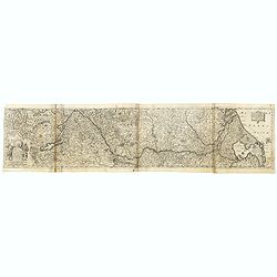
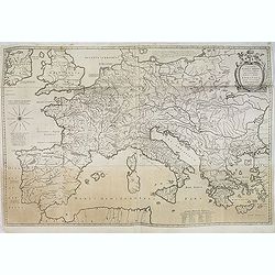
Totius Rheni, ab eius Capitibus ad Oceanu usque Germanicum in quem se Exonerat Novissima Descriptio.
The course of the Rhine river by Henricus Hondius. Originally engraved as two parts on one sheet. Here separated and joined to one large map. The map is showing the compl...
- $300 / ≈ €262
Date: Amsterdam, ca. 1632
Germaniae nova et accurata delineatio.. 1631.
Striking example of Hondius' map of the German Empire, extending from the Low Countries in the Northwest to the Baltic, Poland and Russia in the Northeast and Italy and t...
- $400 / ≈ €349
Date: Amsterdam, 1636
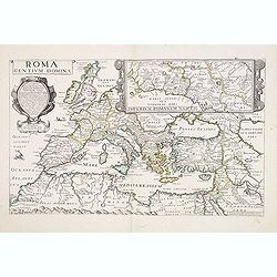
Roma dentium Domina.
Rare map of Europe during the Roman Empire. In upper right corner inset map of the area around Rome "Imperium Romanum Nasces (305x250mm.) Prepared by P.Briet and pub...
- $1500 / ≈ €1309
Date: Paris, 1637
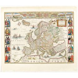
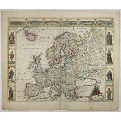
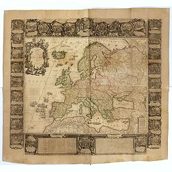
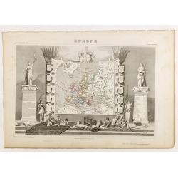
Europa recens descripta à Guilielmo Blaeuw.
On either side columns depicting the manner of dress in the major countries of Europe, surmounted by nine city views and plans.For European mapmakers their own continent ...
Date: Amsterdam, 1644

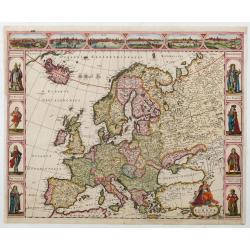
Europa recens descripta à Guilielmo Blaeuw.
On either side, columns depicting the manner of dress in the major countries of Europe, surmounted by nine city views and plans.For European mapmakers their own continent...
Date: Amsterdam, 1644
Imperii Caroli Magni.
Wall map, prepared by Petrus Bertius in 1616. Extensive historical map (four sheets joined) depicting the empire of Charles the Great. Fully engraved with mountains, fore...
- $500 / ≈ €436
Date: Amsterdam, 1650

Wassende graade paskaart vertonende alle de Zeekusten van Europa, de geheele middelandsche Zee…
Wassende graade paskaart vertonende alle de Zeekusten van Europa, de geheele middelandsche Zee, als cock ten Noordwesten, en Noordoosten soo veer als ons tot noch toe bek...
Date: Amsterdam, 1658
Fluviorum Rheni Mosae Mosellae Moeni Neccaris aliorumque minorum in eosdem se exonerantium et regionum circumjacentium descriptio
Fluviorum Rheni Mosae Mosellae Moeni Neccaris aliorumque minorum in eosdem se exonerantium et regionum circumjacentium descriptio Decorative map with 18 vignettes on thr...
- $750 / ≈ €655
Date: Amsterdam, ca. 1660
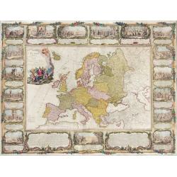
Nova Europae descriptio.
A fine "carte à figures"- map with four panels in columns on each side show portraits of Kings and Queens of European countries. The top border contains panora...
Date: Amsterdam, 1660
Nova Europae descriptio.
Four panels in columns on each side show portraits of the kings and Queens of European countries. The top border contains panoramas of Rome, Amsterdam, Paris, London, Sev...
Date: Amsterdam, c. 1660
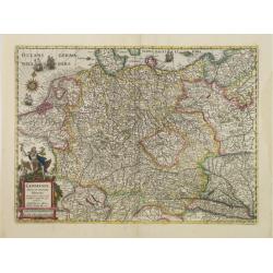
Empire d'Allemagne, divisé en ses dix Cercles ... Royaume de Boheme...
Covering Germany, Low Countries, Poland, Switzerland, Austria and Czech Republic. Nicolas Sanson was to bring about the rise of French cartography, although the fierce co...
- $250 / ≈ €218
Date: Paris, 1665

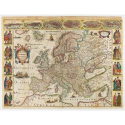
EUROP, and the cheife Cities contayned therin described. . .
A good impression from an early edition of this famous and decorative "carte à figures"- map from the first world atlas produced by an Englishman - John Speed'...
Date: London, 1627 - 1676

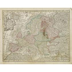
Nova et Accurata totius EUROPAE Descriptio Authore Frederico de Wit Amstelodami.
General map of Europe richly ornamented with small compass rose and Europa shown riding Zeus in the form of a bull, and several putti holding the title banner aloft.
Date: Amsterdam, 1680
![Grande prefecture des Gavels. [de l'Europe / Figure LX] 135](/uploads/cache/38436-250x250.jpg)
Grande prefecture des Gavels. [de l'Europe / Figure LX] 135
A fine and uncommon early 17th-century map of Europe.From the French text edition of "Description d'Univers," 1683. by Allain Manneson Mallet (1630-1706), a wel...
- $30 / ≈ €26
Date: Paris, 1683
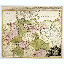
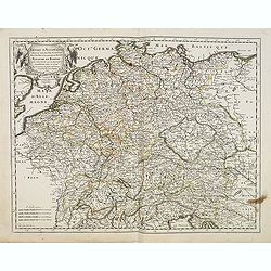
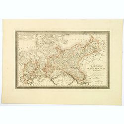
Regni Borussiae et Electoratus Brandenburgici, Ceterarum que, Quae Fridirici Reg. Bor. sceptro reguntur nec non finitimarum Prov. Delineatio. . .
Rare post-route map covering Germany, Poland, the Low Countries, and Czechoslovakia. The map gives in detail the German postal routes and postal stations. Within the lowe...
- $750 / ≈ €655
Date: Amsterdam, 1704
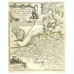
Estats..de Dannemark, Suede, et Pologne..
Rare map of Poland, Denmark, Sweden, The Netherlands, Belgium and Germany. Engraved by H.van Loon. Upper left hand corner fine title cartouche and inset map of the island...
- $400 / ≈ €349
Date: Paris, 1705

Le Cours du Danube depuis sa Source jusqu'a ses Embouchures Dresse sur les Memoires les plus Nouveaux du P. Coronelli et Autres.
Prepared by Nicolas Sanson after V.Coronelli. Large title cartouche lower left with dedication to M.Dauphin.Covers the length of the Danube from its source -west of Ulm t...
- $1300 / ≈ €1135
Date: Amsterdam, 1710

Tabula Novissima Totius Germaniae praecipue ex designatione viri celeberrimi Dni Johannis Caspari Eisenschmidii…
A very rare large map of Germany plus bordering countries, printed from 4 plates. One of Homann's few wall maps, and one of the most accurate maps of Germany at that time...
Date: Nuremberg, ca. 1711
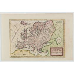
Europa In Praecipuas Ipsius Partes Distributa Ad Observation ..
Although not renowned for the originality of his work, Pieter van der Aa is highly thought of for the design and quality of his output. This map of Europe is a good and d...
Date: Amsterdam 1713
L' Europe Dressée sur les Observations de Mrs. de l' Academie Royale des Sciences..
Charming small map of Europe, including Iceland and the Mediterranean. Based on the geography of Guillaume Delisle.From Le Nouveau et Curieux Atlas Geographique et Histor...
- $150 / ≈ €131
Date: Paris, 1719
L' Europe Dressée sur les Observations de Mrs. de l' Academie Royale des Sciences..
Charming small map of Europe, including Iceland and the Mediterranean. Based on the geography of Guillaume Delisle.From Le Nouveau et Curieux Atlas Geographique et Histor...
Date: Paris, 1719
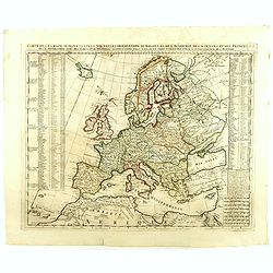
Carte De L'Europe Suivant Les Plus Nouvelles Observations De Messieurs De L'Academie Des Sciences . . .
Includes Iceland, and Russia in the north as well as the Black Sea and the northern tip of Africa in the south. Two tables, listing more than 175 countries along with the...
- $300 / ≈ €262
Date: Amsterdam, 1719
Nouvelle carte des conciles generaux et particuliers . . .
Very handsome map of the lands bordering the Mediterranean Sea, including Great Britain and the Black Sea. The map was drawn to show the cities, & towns where Ecclesi...
- $100 / ≈ €87
Date: Amsterdam, 1721
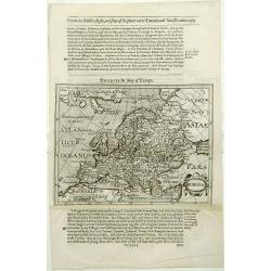
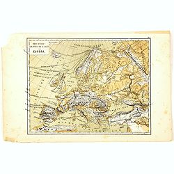
A new map of the Europe according to the New.st Observations. . .
A map showing Europe, including the Caspian Sea in the right.
Date: London, 1725
Europe
A New Map of Europe according to ye Newest Observations (date ca.1730). Image size: 256mmm x 180mm.Herman Moll (1678-1732) was a German emigre from the Hanseatic port cit...
- $100 / ≈ €87
Date: London, ca. 1720-1730
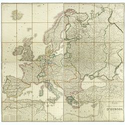
L'Europe Dressée Sur les Nouvelles observations. . .
A rare and monumental wall map of Europe, with original outline color, of four joined sheets, surrounded by text and vignettes printed on separate sheets.Created in 1740 ...
Date: Paris, 1700-1740
L'Europe divisée en tous ses états, dressée sur les nouveaux mémoires et suivant les dernières observations.
Rare wall map of the European continent, published by the Parisian publisher Sébastien G. Longchamp.The map is surrounded by a magnificent Rococo-style frame decorated w...
Date: Paris, 1757
Europa religionis Christiania, morum et pacis. . .
Miniature map of Europe, a reduction of Seutter''s folio map.From Atlas Minor, here published by Johann Martin Will, with his address in bottom center of the map.The cart...
- $200 / ≈ €175
Date: Augsburg, J.M.Will, 1778

Carte d'Europe divisée en ses Empires et Royaumes.
Uncommon and decorative wall map of Europe, prepared by Clouet. Superb decoration including a wonderful rococo border with vignettes describing historical scenes. Below t...
Date: Paris, Mondhare, 1788
L'Europe divisée en des Etats, Empires, Royaumes et Républiques.
Large wall map of Europe with inset map of Iceland and cartouche drawn and etched by Arrivet. Revised edition by Charles François Delamarche (1st ed.: 1767), entitled &q...
Date: Paris, (n.d.) c. 1793/1794

Deutschlands Postkarte begraenzt von Oesterreich, Preussen, Frankreich, Holland, Italien und der Schweiz. . .
A detailed and crucial post-road map prepared by Ignaz Heymann. The map shows the Low Countries, Germany, Poland, Austria, Hungary, etc.Borders in original outline colo...
Date: Triest, 1800
Carte de l'Europe dediée a Son Altesse royale Monseigneur Charles Louis archiduc d'Autriche, prince royal de Hongrie et de Bohéme, chevalier de la Toison d'Or, Grand-Croix de l'ordre...
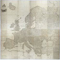
Probably the largest published map of Europe during the regime of Napoleon.In upper left corner a large title cartouche with coats of arms and a dedication to Archduke Ch...
- $4000 / ≈ €3491
Date: Paris, 1803
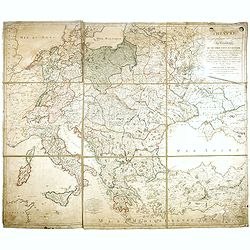
THEATRE Géographique des Guerres du Continent, OU SE TROUVENT EN ENTIER Les Royaumes de Hollande, ...
Large wall map of Central Europe, centered on Poland and including present-day Germany, the Low Countries, Italy, Greece, Bulgaria, Turkey and the Black Sea in the lower ...
Date: Paris, Paul-André Basset, 1806
(Post Roads of Europe) Neueste Allgemeine Postkarte von Europa in welcher samtliche Postrouten aller europaischen Staaten nach den zuverlässigsten Postbüchern. . .
The largest postal map of Europe, published in Vienna in the midst of the Napoleonic Wars. This postal map of Europe first appeared in 1798 and is considered one of the e...
Date: Vienna, 1807
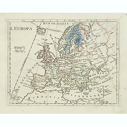
L'Europa.
Charming map of Europe from the rare atlas Atlante Tascabile o sia Serie di Num. XXI Cartine Geografiche nelle quali si rappresenta in ristretto lo Stato Attuale di tutte...
- $60 / ≈ €52
Date: Rome, 1823
Carte Generale du Royaume de Prusse. . .
A nice French map, typical of the period, of the Kingdom of Prussia, by Vivien, from the "Atlas Universel Pour servir a l'Etude De la Geographie et de l'Histoire Anc...
Date: Paris, 1824
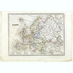
Europe.
Detailed Europe map, prepared by Charles V. Monin (fl.1830-1880) a French cartographer of Caen and Paris. Published in Atlas Universel de Géographie Ancienne &c Mode...
- $50 / ≈ €44
Date: Paris, 1845
Karta öfver Europa.
An very rare map of Europe with a Swedish text. The map is dated 1839.Published as a supplement map in his atlas "Geographisk Hand-Atlas" first published in 181...
- $75 / ≈ €65
Date: A. Wiborgs förlag, Stockholm, ca. 1848
Carta geografica statistica e stradale d'Europa diseguata ed insica da Stanislao Stucchi. . . in Milano 1849.
Large engraved folding map of Europe (1545x1570 mm), consisting of 54 plates linen backed, the boundaries in early hand-color.Stanislao Stucchi was an engraver and printe...
- $600 / ≈ €524
Date: Milan, Turin, 1849
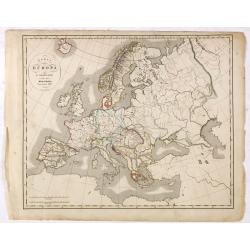
Europe.
While the map itself is quite simple without a great deal of detail, the surrounding engravings make this one of the most decorative 19th century maps. The map is frame...
- $150 / ≈ €131
Date: Paris 1850
Europe.
Fine manuscript map of Europe with relief shown pictorially. Signed by the author in the lower right corner.Lower left Juillet 1852.
- $150 / ≈ €131
Date: Paris, 1852
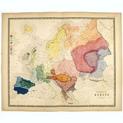
Ethnographic map of Europe by dr. Gustaf Kombst.
Original steel engraving with original hand coloring. A map showing the various ethnicities across Europe with a color key, according to Dr. Gustaf Kombst, published by A...
Date: William Blackwood and Sons, Edinburgh & London, 1856
Carta generale di Europa (Tav IV)
This large-format Europe map is finely engraved and beautifully colored and was prepared by Girolamo Petri, a lawyer who served as a senior official within the Vatican’...
- $750 / ≈ €655
Date: Rome, 1858
Bacino del Mediterraneo (Parte occidentale) . . .
Uncommon map of Mediterranean Basin prepared by Francesco Costantino Marmocchi. Above the map "Geografia Commerciale". From "Il Globo Atlante di carte Geog...
- $50 / ≈ €44
Date: Genova, Paolo Rivara fu Giacomo, 1858
Europa.
Uncommon map of Europe prepared by Francesco Costantino Marmocchi. Above the map "Geografia Commerciale". From "Il Globo Atlante di carte Geografiche compi...
- $50 / ≈ €44
Date: Genova, Paolo Rivara fu Giacomo, 1858
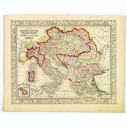
Map of the Austrian Empire, Italian States, Turkey in Europe, and Greece.
A nice example of S. A. Mitchell Jr.'s 1864 map of the Austrian Empire, Italy, Turkey in Europe and Greece. There is an inset in the lower-left corner that features the M...
Date: Philadelphia, 1864

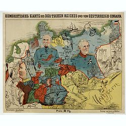
La Pieuvre Germanique.
Scarce lithographed plate not dated, by Eugène Danzanvilliers, printed by Grandremy in Paris. The plate listed by Adhemar is dated 1874. Eugène Danzanvilliers was a dra...
Date: Paris, 28 Quai de la Rapée, c.1874
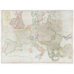
Nouvelle carte physique et politique de l'Europe. Les limites d'états.
A very large, uncommonly updated version of the map of Europe, prepared by H. Brué and updated by A. Vuillemin. In the lower margin, "Nouvelle edition" and a d...
Date: Paris, 1875
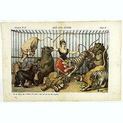
Miss Cora Europea. Papagallo No. 35. Anno VI.
Miss Europa taming the lion (Russia) with other nations shown as animals. Design by Augusto Grossi. Taken from the Italian satirical newspaper Il Papagallo, a satirical m...
Date: Bologne, 1878
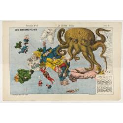
La Piovra Russa. Carta Serio-Comica Pel 1878.
1878 - Rare political caricature map by Grossi of the nations of Europe for the newspaper Le Perroquet / Al papagallo.
Date: Bologne presso il Giornale colorato in Papagallo, 1878
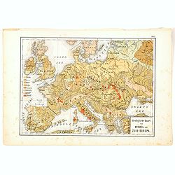
Geologische Kaart van Middel- en Zuid-Europa.
One of the earliest thematic maps published in the Netherlands from "Atlas der natuurkundige aardrijkskunde. . .". prepared by Nicolaas Wilhelmus Posthumus. Wit...
- $35 / ≈ €31
Date: Amsterdam, C.L. Brinkman, 1883
Oro-Hydrographische Kaart van Europa.
One of the earliest thematic maps of Europe published in the Netherlands from "Atlas der natuurkundige aardrijkskunde. . .". prepared by Nicolaas Wilhelmus Post...
- $35 / ≈ €31
Date: Amsterdam, C.L. Brinkman, 1883

Wandkarte von Europa von H.Berghaus. . .
Large wall map of Europe printed in chromo-lithography. Prepared by Heinrich Berghaus and published by Justus Perthes in Gotha.Heinrich Berghaus, with support of Alexande...
Date: Gotha, Perthes, ca.1885
![[map printed on a tissue] The British remedy for coughs and colds. Owbridge's lung tonic.](/uploads/cache/40288-250x250.jpg)
[map printed on a tissue] The British remedy for coughs and colds. Owbridge's lung tonic.
Handkerchief showing a map of Europe and part of Asia continent printed on a tissue. OWBRIDGE’S LUNG TONIC, THE BRITISH REMEDY FOR COUGHS AND COLDS.Walter Thomas Owbrid...
- $400 / ≈ €349
Date: London, ca. 1900

A Humorous Diplomatic Atlas of Europe and Asia. / 滑稽欧亜外交地図 / Kokkei Ō-A Gaikō Chizu.
A wonderful example of the rare 1904 Kisaburo Ohara satirical 'Octopus Map' of Europe being swallowed by an octopus (Russia). Composed at the outbreak of the Russo-Japane...
Date: Tokyo, April, 1904

Hark ! Hark ! The dogs do bark.
This scarce political caricature map of Europe depicts the continent at the outbreak of World War I, or as it was called at the time, the Great War. Designed by Johnson, ...
Date: London, Johnson Riddle & Co.,1914

Karte von Europa im Jahre 1870 nach einem französischen Holzschnitte.
Satirical illustration by Paul Hadol showing disposition of power in Europe at the beginning of 1870. Satirical print depicting a map of Europe in which the countries are...
Date: Hamburg, Fuchs, 1914

Mappa Humoristico da Europa.
A really unusual and lovely map, published in Portugal at the outbreak of The Great War in 1914. This outbreak of war in Europe was the result of a complex sequence of ev...
Date: Lisbon, 1914
Humoristische Karte von Europa im Jahre 1914.
A satirical map of Europe with a title in German that marks the outbreak of the First World War, probably conceived between August and October 1914. Lehmann-Dumont was no...
Date: Dresde, Leutert & Schneidewind, ca. 1914
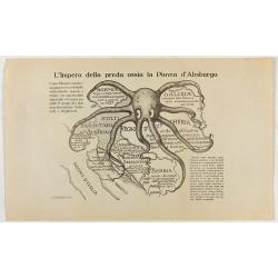
L'Impero della preda ossia la Piovra d'Absburgo.
Austro-Hungarian Octopus zinc lithographed map. A propaganda sheet attacking the Austro-Hungarian Empire, showing it as an octopus with its tentacles wrapped around the v...
Date: La Zincografia, Milan, c. 1915
![[Cloth Map of Europe]](/uploads/cache/47148-250x250.jpg)
[Cloth Map of Europe]
Anglo-centric cloth map of Europe produced during WWI.Serbia, the spark that lit the conflagration of World War One, isn’t even labeled on this interesting cloth map of...
Date: London, c. 1915

Völker Europas wie schön sind eure Geschichter. (World War I post card)
During the Great War, when the only means of communicating news to the masses was by newspapers and weekly illustrated magazines, the ‘war’ or 'military' picture post...
Date: Germany, 1915
![[2 maps] Das Europa der Zukunft... / Das heutige Europa…[The Europe of the Future / The Europe of Today]](/uploads/cache/48735-250x250.jpg)
[2 maps] Das Europa der Zukunft... / Das heutige Europa…[The Europe of the Future / The Europe of Today]
A pair of very scarce WWI German maps highlighting Europe as it currently was, and Europe as it may become. The maps were produced as part of an 8 page booklet produced b...
- $2750 / ≈ €2400
Date: Paris, 1917
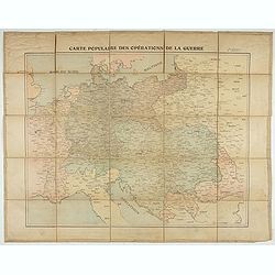
Carte populaire des opérations de la guerre. 2ème édition.
Folding map. War Operations Map showing a part of Europe, published by Epinal.
Date: Paris, ca. 1919

L'Europe en Sept 1939. Ille terrarum mihi angulus ridet.
A rare oversized serio-comic map of Europe at the start of the Second World War depicting stereotypes of 31 countries, as listed in the key lower right, including Brit...
Date: Bruges, Leon Burghgraeve, 1939
