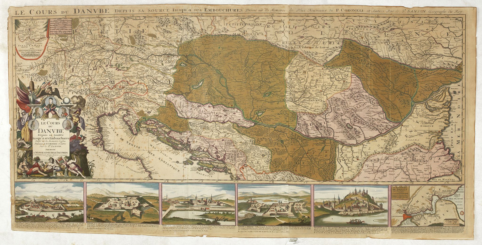
1710 COVENS, J. / MORTIER, C. - Covers the length of the Danube from its source -west of Ulm to the Black Sea.
Le Cours du Danube depuis sa Source jusqu'a ses Embouchures Dresse sur les Memoires les plus Nouveaux du P. Coronelli et Autres.
| Maker: | COVENS, J. / MORTIER, C. | |
| Date: | Amsterdam, 1710 | |
| Colored: | In attractive original colors. | |
| Size: | 580 x 1200 mm / 22.8 x 47.2 inches | |
| Condition: | Printed on 3 joined sheets of paper. Paper browned. Some paper thinness on vertical folds. Margins a bit frayed and some repaired marginal tears. | |
 Add/Remove this item to MyCollection+




Description
Covers the length of the Danube from its source -west of Ulm to the Black Sea.
The elaborate title cartouche has portraits of local rulers, figures symbolizing river sources, and a variety of weapons and characters, including the military struggles between Europe and the Turks throughout this area.
Six panels below the map show views of Varadin, Camise, Temeswar, Zigeth, Belgrad, and an inset map of the Bosporus including Istanbul.
More about figured border maps [+]
Covens & Mortier (Amsterdam, 1721–c. 1866)
For almost two centuries, Covens & Mortier was the most important Dutch publishing house in commercial cartography. It was also the last great Amsterdam map firm of the 18th century.The firm’s roots lie with Pierre (Pieter) Mortier (1661–1711), who spent the early 1680s in Paris before receiving the right to publish the maps of French cartographers in Amsterdam. He was an engraver and the son of a French refugee. This privilege made him the Dutch outlet for Delisle, Jaillot, Sanson and their contemporaries. After his death in 1711, the business passed to his widow (until 1719), then to his son Cornelis and his brother David (until 1721).
On 20 November 1721, Cornelis Mortier and Johannes Covens I founded the company. Covens had recently married Cornelis’s sister, so the firm was a family enterprise from the start.
The firm mainly published French geographers including Delisle, Jaillot and Sanson, and reissued Frederik de Wit’s Atlas Major in 1725. It also issued pocket atlases and town atlases. Its growth came largely from acquiring other publishers’ copperplates. The purchase of Pieter van der Aa’s plates in 1730 is a notable example. Its stock also included plates going back to Johannes Janssonius and Claes Jansz. Visscher. At its height, the firm held the largest collection of geographic prints ever assembled in Amsterdam.
FAQ - Guarantee - Shipping
Buying in the BuyNow Gallery
This item is available for immediate purchase when an "Add to Cart" or "Inquire Now" button is shown.
Items are sold in the EU margin scheme.
Payments are accepted in Euros or US Dollars.
Authenticity Guarantee
 We provide professional descriptions and a condition report (based on 45 years experience in the map business).
Paulus Swaen warrants the authenticity of our items and a certificate of authenticity is provided for each acquired lot.
Condition and Coloring
We indicate the condition of each item and use our unique HiBCoR grading system in which four key items determine a map's value:
Historical Importance, Beauty, Condition/Coloring and Rarity.
We offer many maps in their original black and white condition. We do not systematically color-up maps to make them more sellable to the general public or buyer.
Copper engraved or wood block maps are always hand colored. Maps were initially colored for aesthetic reasons and to improve readability.
Nowadays it is becoming a challenge to find maps in their original colors, and these are therefore more valuable.
We use the following color keys in our catalog:
- Original colors: the colors were applied around the time the map was issued.
- Original o/l colors: only the borders were colored at the time of publication.
- Colored: the colors were applied recently or at the end of the 20th century ("attractive colors" may also be used).
Read more about coloring of maps [+]
Shipping fee
A flat shipping fee of $30 is added to each shipment by DHL within Europe and North America. This covers international priority shipping, packing and insurance (up to the invoice amount).
Shipments to Asia are $40 and rest of the world $50.
We charge only one shipping fee when you have been successful on multiple items or when you want to combine gallery and auction purchases.
Read more about invoicing and shipping
FAQ
Please have a look for more information about buying in the BuyNow gallery.
Many answers are likely to be found in the general help section.
MyCollection+

With MyCollection+ you can collect all your favorite items in one place. It is free, and anyone can create his or her virtual collection.
Unless you are logged in, the item is only saved for this session. You have to be registered and logged in if you want to save this item permanently.
Read more [+]
Register here, it is free and you do not need a credit card.
Add this item to
MyCollection+
or see MyCollection+.
Paulus Swaen maintains an archive of most of our high-resolution rare maps, prints, posters and medieval manuscript scans.
We make them freely available for download and study.
Read more about free image download
Click the image for a free small image download.
YOUR RIGHT TO CANCEL THE PURCHASE OF A LOT
In accordance with the EU Consumer Rights Directive and habitually reside in the European Union you have the right to cancel the contract for the purchase of a lot, without giving any reason.
The cancellation period will expire 14 calendar days from the day after the date on which you or a third party (other than the carrier and indicated by you) acquires, physical possession of the lot. To exercise the right to cancel you must inform Paulus Swaen Inc, of your decision to cancel this contract by a clear statement (e.g. a letter sent by post, or e-mail.
To meet the cancellation deadline, it is sufficient for you to send your communication concerning your exercise of the right to cancel before the cancellation period has expired.
