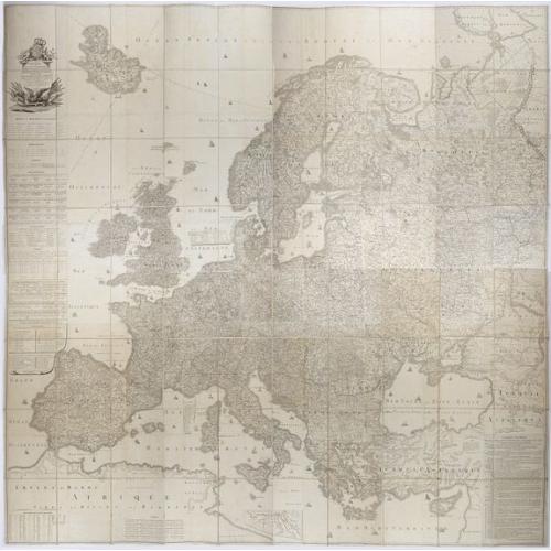
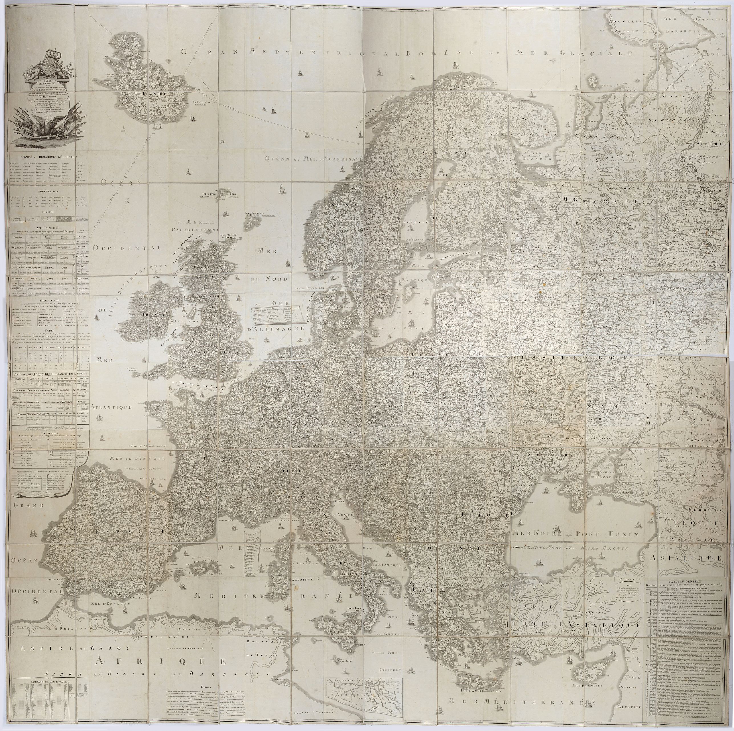
Description
Probably the largest published map of Europe during the regime of Napoleon.
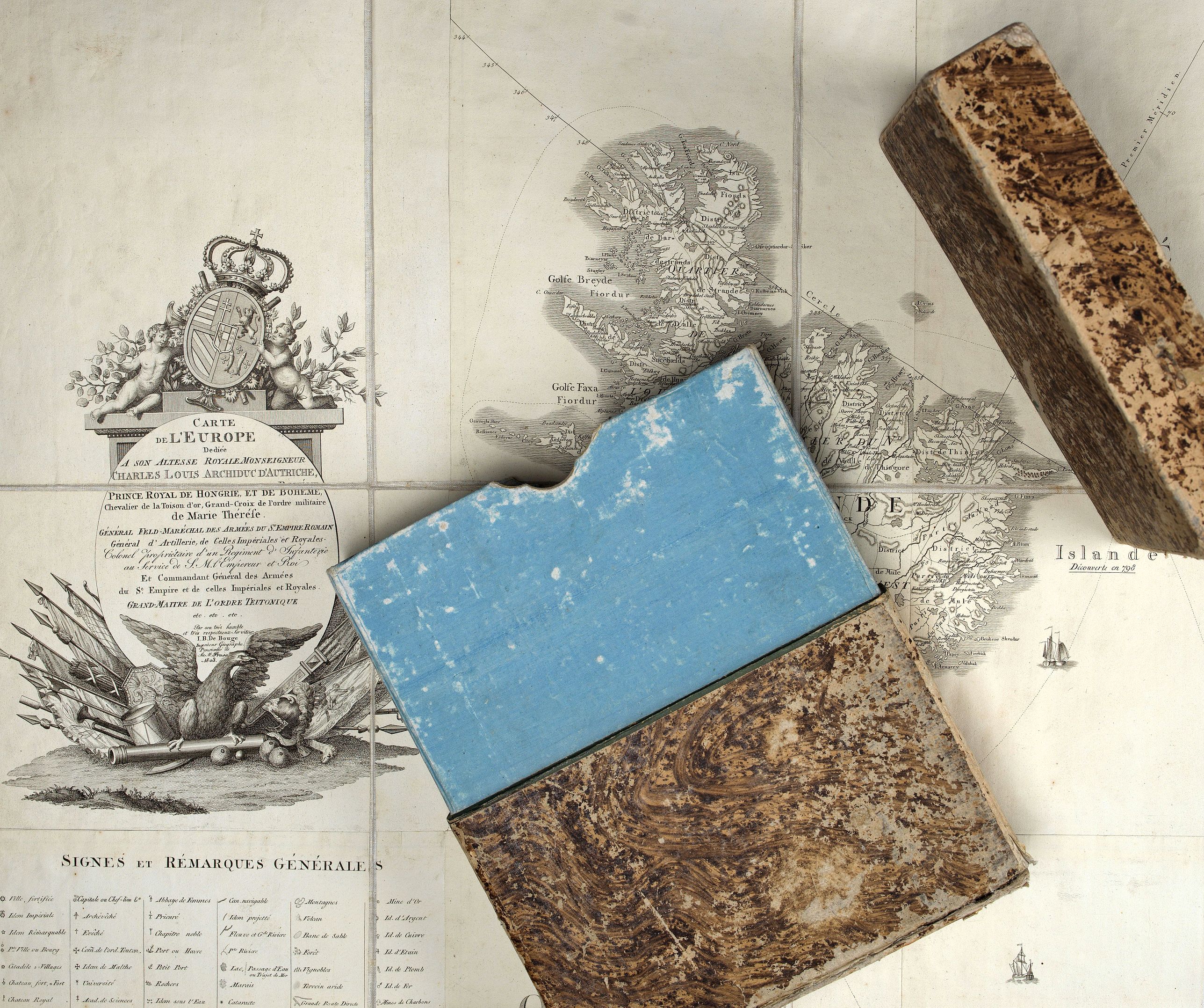
In upper left corner a large title cartouche with coats of arms and a dedication to Archduke Charles of Austria, dated 1803.
Under neath the title cartouche extensive tables and information.
According to WorldCat earlier edition of 1799 and 1800 exist. Only 4 examples are listed.
This is the 1803 edition and to the lower right hand a past-on with an historical explanation from 1772 until 1803 (Year XI) : TABLAEU GENERAL. Des changements survébus en Europe depuis 1772 jusqu'en 1803 (an XI). Published by Jean Baptiste de Bouge (1757-1833) has been added.
Jean Baptiste de Bouge (1757-1833) was a Parisian surveyor, engraver, geographer and publisher , who also worked in The Hague and Vienna.
Charles ( 5 September 1771 – 30 April 1847 was an Austrian field-marshal, the third son of emperor Leopold II and his wife Infanta Maria Luisa of Spain.
Charles achieved respect both as a commander and as a reformer of the Austrian army. He was considered one of Napoleon's most formidable opponents.
He began his career fighting the revolutionary armies of France. Early in the wars of the First Coalition, he saw victory at Neerwinden in 1793, before tasting defeat at Wattignies 1793 and Fleurus 1794. In 1796, as chief of all Austrian forces on the Rhine, Charles out-generaled Jean-Baptiste Jourdan at Amberg and Würzburg. He forced Jean Victor Marie Moreau to withdraw across the Rhine, and followed these victories with others at Zürich, Ostrach, Stockach, and Messkirch in 1799. He reformed Austria's armies to adopt the nation at arms principle, in 1809, he went into the War of the Fifth Coalition with confidence and inflicted Napoleon's first major setback at Aspern-Essling, before suffering a defeat at the bloody Battle of Wagram.
Following Wagram, Charles saw no more significant action in the Napoleonic Wars.
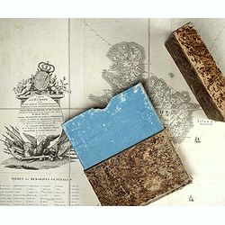
The map measures more than 2 meters and is kept in its original box. Mint condition.
More about folding maps. [+]
In upper left corner a large title cartouche with coats of arms and a dedication to Archduke Charles of Austria, dated 1803.
Under neath the title cartouche extensive tables and information.
According to WorldCat earlier edition of 1799 and 1800 exist. Only 4 examples are listed.
This is the 1803 edition and to the lower right hand a past-on with an historical explanation from 1772 until 1803 (Year XI) : TABLAEU GENERAL. Des changements survébus en Europe depuis 1772 jusqu'en 1803 (an XI). Published by Jean Baptiste de Bouge (1757-1833) has been added.
Jean Baptiste de Bouge (1757-1833) was a Parisian surveyor, engraver, geographer and publisher , who also worked in The Hague and Vienna.
Charles ( 5 September 1771 – 30 April 1847 was an Austrian field-marshal, the third son of emperor Leopold II and his wife Infanta Maria Luisa of Spain.
Charles achieved respect both as a commander and as a reformer of the Austrian army. He was considered one of Napoleon's most formidable opponents.
He began his career fighting the revolutionary armies of France. Early in the wars of the First Coalition, he saw victory at Neerwinden in 1793, before tasting defeat at Wattignies 1793 and Fleurus 1794. In 1796, as chief of all Austrian forces on the Rhine, Charles out-generaled Jean-Baptiste Jourdan at Amberg and Würzburg. He forced Jean Victor Marie Moreau to withdraw across the Rhine, and followed these victories with others at Zürich, Ostrach, Stockach, and Messkirch in 1799. He reformed Austria's armies to adopt the nation at arms principle, in 1809, he went into the War of the Fifth Coalition with confidence and inflicted Napoleon's first major setback at Aspern-Essling, before suffering a defeat at the bloody Battle of Wagram.
Following Wagram, Charles saw no more significant action in the Napoleonic Wars.
The map measures more than 2 meters and is kept in its original box. Mint condition.
More about folding maps. [+]
FAQ - Guarantee - Shipping
Buying in the BuyNow Gallery
This item is available for immediate purchase when a "Add to Cart" or "Inquire Now" button is shown.
Payments are accepted in Euros or US Dollars. We accept most major credit cards, PayPal and bank transfer.
Authenticity Guarantee
 We provide professional descriptions, condition report and HiBCoR rating (based on 45 years experience in the map business)
We fully guarantee the authenticity of items we sell. We provide a certificate of authenticity for each purchased item.
Condition / Coloring
We indicate the condition of each item and use our unnique HiBCoR grading system in which four key items determine a map's value: Historical Importance, Beauty, Condition/Coloring and Rarity.
We offer many maps in their original black and white condition. We do not systematically color-up maps to make them more sellable to the general public or buyer.
Copper engraved or wood block maps are always hand colored. Maps were initially colored for aesthetic reasons and to improve readability. Nowadays, it is becoming a challenge to find maps in their original colors and are therefor more valuable.
We use the following color keys in our catalog:
Original colors; mean that the colors have been applied around the time the map was issued.
Colored; If the colors are applied recently or at the end of the 20th century, then "colored", or "attractive colors" will be used.
Original o/l colors; means the map has only the borders colored at the time of publication.
Read more about coloring of maps [+]
FAQ
Please have a look for more information about buying in the BuyNow gallery.
Many answers are likely to find in the general help section.
Collection
![]()
With Collection you can collect all your favorite items in one place. It is free, and anyone can create his or her virtual map collection.
Unless you are logged in, the item is only saved for this session. You have to be registed and logged-in if you want to save this item permanently to your collection.
Read More [+]
If you want to save the items permanently, please sign in
or create account first. ![]()
Registering Here, it is and you do not need a credit card.
Add this item to
Collection
or click the following link to see my Collection.
Invoice
The invoice and certificates of authenticity are available in the client center >Invoices
| Digital Image Download | |
|
Paulus Swaen maintains an archive of most of our high-resolution rare maps, prints, posters and medieval manuscript scans. We make them freely available for download and study. Read more about free image download |
Click the image for a free small image download. |
In accordance with the EU Consumer Rights Directive and habitually reside in the European Union you have the right to cancel the contract for the purchase of a lot, without giving any reason.
The cancellation period will expire 14 calendar days from the day after the date on which you or a third party (other than the carrier and indicated by you) acquires, physical possession of the lot. To exercise the right to cancel you must inform Paulus Swaen Inc, of your decision to cancel this contract by a clear statement (e.g. a letter sent by post, or e-mail (amsterdam@swaen.com).
To meet the cancellation deadline, it is sufficient for you to send your communication concerning your exercise of the right to cancel before the cancellation period has expired.
