Browse Listings in Europe
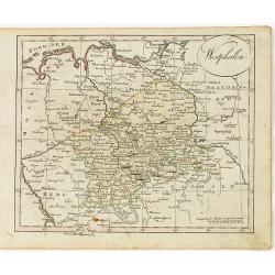
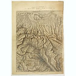
Westphalen.
Nice small map of Westphalia in Germany by Johannes Walch in his rare Allgemeiner Atlas Nach den bewährsten Hülfsmitteln und astronomischen Ortsbestimungen…, edition ...
- $50 / ≈ €42
Date: Augsburg, 1812
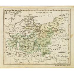
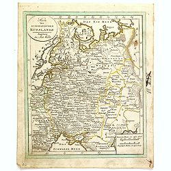
Brandenburg und Pommern.
Nice small map of Brandenburg and Pommeren, centered on Berlin by Johannes Walch in his rare Allgemeiner Atlas Nach den bewährsten Hülfsmitteln und astronomischen Ortsb...
- $75 / ≈ €64
Date: Augsburg, 1812
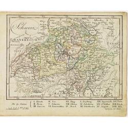
Schweiz.
Nice small map of Switzerland by Johannes Walch in his rare Allgemeiner Atlas Nach den bewährsten Hülfsmitteln und astronomischen Ortsbestimungen…, edition of 1812.Jo...
- $60 / ≈ €51
Date: Augsburg, 1812
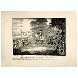
Entrée des Français dans la ville de Moscou . . .
View of the French's army entering Moscow on 14 September 1812 during the Napoleonic Wars (1800-1815) in Russia.
- $75 / ≈ €64
Date: Brussels, ca. 1812
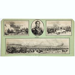
Passage de la Berezinas.
Set of four views of The Battle of Berezina (or Beresina) which took place from 26 to 29 November 1812, between the French army of Napoleon, retreating after his invasion...
Date: ca. 1812

Carte des routes de poste de la Russie européenne, exécutée par ordre de S.E.M. le duc de Feltre ministre de la Guerre, ...
Post-route map on a scale of 1:2 500 000 made during the French campaign in Russia, which began June 24, 1812. With a table of the conventional signs and a table of conve...
Date: Paris, Dépôt Général de la Guerre 1812
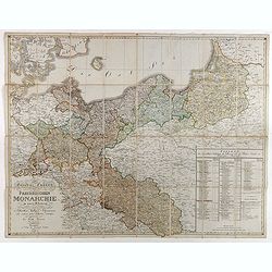
General Charte der Preussischen Monarchie in zwey Blattern. . .
Uncommon and detailed map of Kingdom of Prussia with present day Poland and Germany. Uncommon map engraved by Ludwig Hess and published in Weimar by Fr. Wilhelm Streit.
- $1000 / ≈ €847
Date: Weimar, 1812
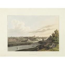
Smolensko.
View of this small town in Russia just before the First Battle of Smolensk which took place on August 17, 1812, between 175,000 men of the army under Napoleon Bonaparte a...
- $225 / ≈ €191
Date: London, 1814
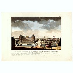
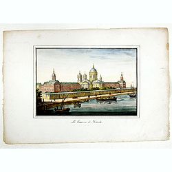
Vue de la ville de St. Pétersbourg capitale de la russie prise du côté de la Fontanka . . .
This aquatint print figures the town of St. Peterburg. With address "A Paris chez le Coeur graveur, rue Mouffetard, N° 89 et chez Bance aîné, rue Saint Denis, N°...
Date: Paris, Le Cœur et Bance ainé, ca 1814
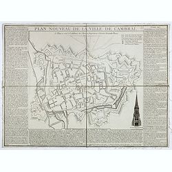
Plan nouveau de la ville de Cambrai.
Nice town-plan of Cambrai, with its fortifications and the citadel, decorated with the cathedral in lower right corner. The borders contain a historical description of th...
Date: Cambrai, 1814

Juan II Jvanovitz, il monta sur le trône en 1353, et mourut en 1358.
Portrait of Juan II Jvanovitz., engraved by Louis Legrand (1723-1807).
- $50 / ≈ €42
Date: Paris, 1814
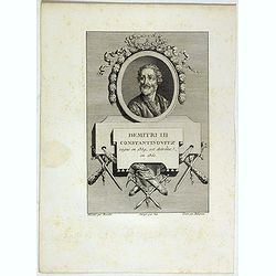
Demitri III Constantinovitz, regne en 1359, est detrône en 1361.
Portrait of Demitri III Constantinovitz., Grand Duke of Russia, engraved by C.-N. Malapeau.
- $75 / ≈ €64
Date: Paris, 1814
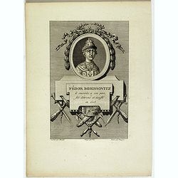
Fédor Borissovitz il succéda a son père, fut détroné et étouffé en 1505.
Portrait of Fédor Borissovitz. (1589 - 1605), engraved by Louis Pauquet (1759-1824).
- $75 / ≈ €64
Date: Paris,1814

Vasili Juanovitz Chouiski regne en 1606 est detrône en 1610.
Portrait of Vasili Juanovitz Chouiski or Vasili IV of Russia (1552 – 1612) was Tsar of Russia between 1606 and 1610 after the murder of False Dmitriy I. His reign fell ...
- $45 / ≈ €38
Date: Paris, 1814
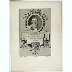
Demitri IV Juanovitz Donski regne en 1362, et meurt en 1389.
Portrait of Demitri IV Juanovitz or Vasili IV of Russia who was Tsar of Russia between 1606 and 1610 after the murder of False Dmitriy I. His reign fell during the Time o...
- $75 / ≈ €64
Date: Paris, 1814
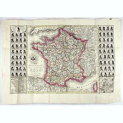
Carte du royaume de France divisé en 87 départemens / dressée par Brion de la Tour..., où sont tracées les nouvelles limites fixées par le traité de paix du 30 mai 1814. . .
Very decorative and uncommon map of France, with Corsica prepared by Brion de la Tour showing the new border set by the Peace Treaty of May 30, 1814. Engraved by Chaumier...
Date: Paris, ca. 1814
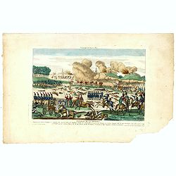
Bataille de la Moskwa Remportée par l'Armée Française le 7 Septembre 1812...
Uncommon print showing the siege of Moscow on September 7, 1812 by Napoleon Bonaparte.Jean was a well-known publisher of optical prints and other popular prints, establis...
Date: Paris, ca. 1815
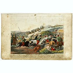
Gefecht bei Daoughelichki, den July 1812.
Rare German print showing the siege of Daoughelichki, July 1812, during the French Russian Campaign, which ended in Napoleon's defeat.
- $150 / ≈ €127
Date: Nuremberg, ca. 1815
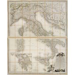
Carte Statistique, Politique, et Mineralogique de l'Italie o'u sont tracées toutes les routes, relais, et distances de postes. . .(2 Maps)
Folding map, extending west to east from Monaco to Otranto and north to south from The Alps to Malta, inset of Greece,. Cartouche depicting Rome and her classical past. P...
Date: Paris, 1816

Woman of Brabant.
Very fine view of a woman wearing the traditional dress of Brabant.
Date: London, 1817
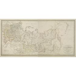
Charte des ganzen Russischen Reichs in Europa und Asien : Nach den neuesten und sichersten astronomischen Ortsbestimmungen entworfen und berichtiget auf der Sternwarte Seeberg bey Gotha gezeichnet von I. C. M. Reinecke. . .
Uncommon two-sheet map of Russia, prepared by Johann Matthias Christoph Reinecke (1770-1818). The map's information is off by 20 degrees longitude as the prime meridian ...
Date: Weimar, 1817
Nouveau voyage pittoresque de la France Orné de trois cent soixante gravures exécutées sur des dessins fait d'après nature, et représentant des Vues des principales Villes de France, ...
Large paper copy, printed on quarto format (210x235mm.) on heavy paper. Illustrated with 360 engraved plates, many by Jean-Jerome Baugean. Without the large folding map....
- $2200 / ≈ €1863
Date: Paris, 1817

Langley's New Travelling and Commercial Map . . .
A highly desirable, detailed and uncommon map of England and Wales, published by Langley and Belch. The map is flanked by a pair of large and detailed explanation tables,...
Date: London, 1817
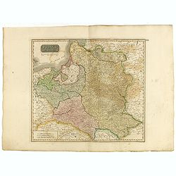
Poland As Divided.
This map covers Poland following Napoleonic Wars and the treaties of the 1815 Congress of Vienna.This map was first published in Thomson's New General Atlas of 1814. John...
Date: Edinburgh, 1817

Nuova Pianta Iconografica.. Venezia.
Venice's precise bird' s-eye town plan clearly depicts the city's architectural landmark. A reduction of Ughi's 8-sheet map of 1725. A grid is engraved over the plan, ref...
Date: Venice, 1818
Département de la Drome decreté le 3 février 1790. . .
Map of the region of southeast France. The region of Drome is divided into four districts. On the left, the title with underneath a large explicative text with the divisi...
Date: Paris, 1790-1818
Situations = Plan. Der gegend zwischen der Kayserlich Königlichen Granitz Festung Essegg, und dem Dorffe Bellia....
Manuscript plan showing the Kopački Rit nature park a swampy area of Baranja between Osijek (Essegg) and Bilje. The river Drava in upper right corner. The pen an...
Date: Vienna, 1819

Vue de Gattweick et de l'embouchure du Rhin, dans la Mer du Nord.
Very decorative view of Katwijk. Signed lower right, Louis Bleuler au chateau de Laufen . Original design by Louis Bleuer. This gouache was the model for his aquatint in ...
Date: 1820
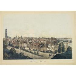
Hamburg im Jahre 1813
Decorative lithographed view of Hamburg. The print is issued in colors but finished by hand.
- $150 / ≈ €127
Date: Germany,1820
![[No tittle] Partie de la Prusse.](/uploads/cache/30632-250x250.jpg)
[No tittle] Partie de la Prusse.
Detailed map of the south of Baltic Sea. With a paper printed label of the Paris map seller Jean Goujon who was active from 1793-1826. The label carries the address of Ru...
- $90 / ≈ €76
Date: Paris, c. 1820
Karte des Europaeischen Russland. . ..
Nice small map of Russia.
- $100 / ≈ €85
Date: Augsburg, 1820
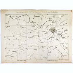
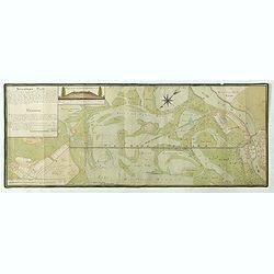
Tableau d'assemblage de la carte des environs de Versailles dite chasses impériales.
Key sheet to the rare 12 sheet map "Carte topographique des environs de Versailles dite des Chasses Impériales, levée et dressée de 1764 à 1773 par les ingénieu...
Date: Paris, ca. 1820
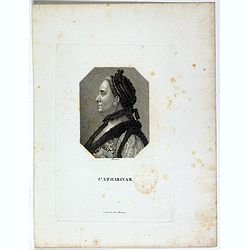
Catharina II.
Portrait of Catharina II (1729-1796) or Catherine the Great, Empress of Russia. During the reign of the flamboyant and powerful Empress Catherine II of Russia, whose long...
- $60 / ≈ €51
Date: Germany, ca. 1820

Le Baron d'Amstett. Ministre de Russie.
Full portrait of Johann Protasius von Anstett (* 1766 in Straßburg; † 14. Mai 1835) after Lieder and lithographed by G.Engelmann. Anstett, son of a lawyer in Strasbour...
- $40 / ≈ €34
Date: Paris, ca. 1820
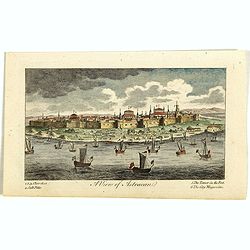
A View of Astracan. (Astrakhan)
A striking and highly detailed copper engraved panoramic view of Astrakhan, Russia, with its buildings, churches and town wall. The River Volga in the foreground. Several...
- $50 / ≈ €42
Date: London, 1820
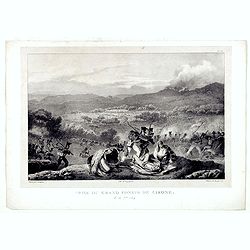
Prise du Grand Convoi de Girone le 26 Fbie 1809.
Fine lithography showing a battle scene during Third Siege of Girona by Godefroy Engelmann" after a drawing by C. Langlois. Godefroy Engelmann was born in 1788 in M�...
Date: Paris, ca. 1820
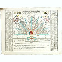
Tableau figuratif de la Chambre de Députés . . .
Figurative table of the Chamber of Deputies for the session of 1821. Showing as accurately as possible the place usually occupied by each of its members.
Date: Paris, ca. 1821

London in Miniature With The Surrounding Villages. An Entire New Plan In which the Improvements both present and intended are actually reduced, by permission, from the surveys of the Several Proprietors. . .
Hand-coloured engraved map, dissected and mounted on linen, orange publishers label on one side, extending west to east from Kensington to East India and Greenwich Dock a...
Date: London, 1821
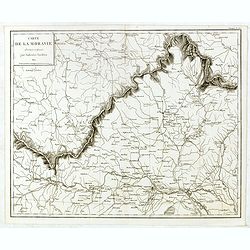
Carte de Moravie Dessinée et Gravée par Ambroise Tardieu.
Very detailed map including Vienna and the Czech Republic with Prague Olmutz.
- $40 / ≈ €34
Date: Paris, 1822
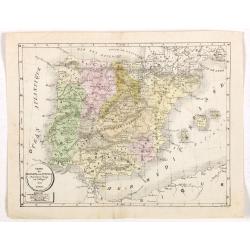
Carte de l'Espagne et du Portugal dréssée pour l'usage des Collèges 1822.
Uncommon lithographed map of Spain and Portugal taken from " Atlas Géographique. Géographie moderne actuelle. Pour l'usage des Collèges."
Date: Paris, 1822
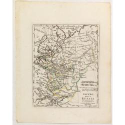
Impero della Russia in Europa a riserva delle ultime Conquiste sulla Polonia.
Charming map of the European part of Russia, including Finland, from the rare atlas Atlante Tascabile o sia Serie di Num. XXI Cartine Geografiche nelle quali si In Roma...
- $200 / ≈ €169
Date: Rome, 1823
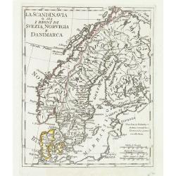
La Scandinavia o sia i regni di Svezia, Norvegia e Danimarca.
Charming and uncommon map of Scandinavia, including Norway, Sweden, Denmark, Finland and part of Russia, from the rare atlas Atlante Tascabile o sia Serie di Num. XXI Car...
Date: Rome, 1823
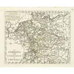
La germania con i Paesibassi e l'elvezia.
Charming map of Germany, The Netherlands, Switzerland and part of Poland from the rare atlas Atlante Tascabile o sia Serie di Num. XXI Cartine Geografiche nelle quali si ...
- $80 / ≈ €68
Date: Rome, 1823
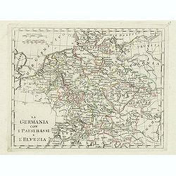
La germania con i paesi bassi e l'elvezia.
Charming map of Germany, Netherlands, Switzerland, Austria from the rare atlas Atlante Tascabile o sia Serie di Num. XXI Cartine Geografiche nelle quali si rappresenta in...
- $65 / ≈ €55
Date: Rome, 1823
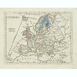
L'Europa.
Charming map of Europe from the rare atlas Atlante Tascabile o sia Serie di Num. XXI Cartine Geografiche nelle quali si rappresenta in ristretto lo Stato Attuale di tutte...
- $60 / ≈ €51
Date: Rome, 1823

Het Huisje door Czaar Peter den Grooten in den Jare 1697 te Zaandam bewoond.
Engraved by Cornelis van Baarsel (Utrecht 1761 - Amsterdam 1826-08-17) after a design of T. Monsieur M.Z. who made his drawing "after nature".A first state, the...
Date: Zaandam, 1823
Carte de la Georgie et du Pays des Ossetes, Tcherkesses et Mitzdcheghi, Par Jules Klaproth (1823).
Detailed manuscript map of Georgia, based upon an 1823 map by Jules Klaproth. The map depicts the rugged terrain of Georgia and southern Russia in impressive detail from ...
- $4000 / ≈ €3388
Date: Paris, ca. 1823
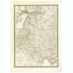
![[Untitled map of a part of Poland and Prussia].](/uploads/cache/25710-250x250.jpg)
[Untitled map of a part of Poland and Prussia].
Large folding map, being upper right part of a multi-sheet map, showing the northern part of Poland with good detail around Gdansk. Published by Jean Claude Dezauche (17...
- $400 / ≈ €339
Date: Paris, ca. 1816-1824
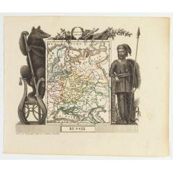
Russie
Attractive map of Russia with decorative borders depicting typical artefacts and produce of the continent. Published in Les jeunes voyageurs en Europe.. . Engraved by J.G...
- $100 / ≈ €85
Date: Brussels, 1824

Le Chantier d'Amsterdam.
Decorative lithography representing the head quarters of the V.O.C. and shipyard in Amsterdam. The building serves nowadays as the Maritime Museum. After a painting by A....
Date: Brussels, J. B. A. Jobard, 1825
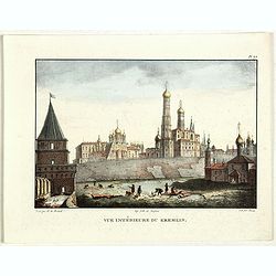
Vue du Kremlin à Moscou.
View of the Kremlin, lithographed by Brocas after a design by Edouard de Montulé. Lithography was printed by Langlumé in Paris. Taken from : Voyage en Angleterre et en ...
- $125 / ≈ €106
Date: Paris, Arthus Bertrand, 1825
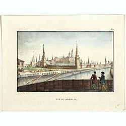
Vue du Kremlin.
View of the Kremlin, lithographed by Brocas after a design by Edouard de Montulé. Lithography was printed by Langlumé in Paris. Taken from : Voyage en Angleterre et en ...
- $125 / ≈ €106
Date: Paris, Arthus Bertrand, 1825
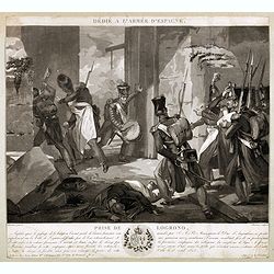
Dédié à l'armée d'Espagne. Prise de Logrono.
Very decorative plate showing the taking of Logrono in 1823, decorative mezzotint by Louis-François Charon (1783-1839) after F.N.Martinet. Published by Jean, Editeur, Ma...
Date: Paris, 1825

Province de Pologne contenant 22 Col. une M.on Prof 5 Pen. 2 Nov. 6 Rés. 30 Maisons 1050 Jésuites.
Rare map of Poland from "Atlas Universel indiquant les établissemens des Jésuites: avec la manière dont ils divisent la terre, suivi desévénemens remarquables d...
Date: Paris, Ambroise Dupont , 1826
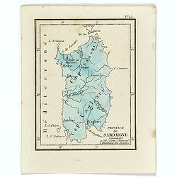
Province de Sardaigne.
Province de Sardaigne Contenant 9 Col. 1 Sem. 1 Noviciat, 2 Résidences 300 Jésuites". Publiée dans "Atlas Universel indiquant les établissemens des Jésuite...
Date: Paris, Ambroise Dupont , 1826
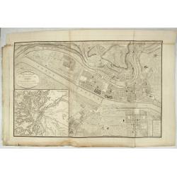
Nouveau Plan Géométral de la Ville de Lyon, Avec ses projets d'agrandissement & d'embellissement, Divisé par Arrondissements;
Large map of Lyon with, at the bottom left, a large inset depicting "The surroundings of Lyon, according to Cassini" and at the bottom right, a double table of ...
Date: Lyon, Chez Vegezzy, M.d d'Estampes,1826
Habillement des Groënlandais.
Natives of Greenland. This aquatint engraved plate was color printed on fine wove paper of a soft aged white color, bearing the embossed seal of authenticity impressed at...
- $75 / ≈ €64
Date: Milan, 1827

Bernoise.
A decorative costume print from "Costume de div. Pays", No.17. Engraved by Getine after Lanté.
- $80 / ≈ €68
Date: Paris, c. 1827
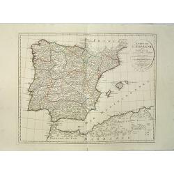
Carte de l'Espagne Dressée par Guillaume Delisle sur la description de Rodrigo Mendez Sylva . . .. Le tout augmenté et vérifié en 1789. Par Phil. Buache, de l'Académie des Sciences.
Map of Spain and Portugal, including the North African coast and good detail for Majorca, Minorca and Ibiza. Published by Dezauche at his address Rue de Sorbonne, n°9, a...
Date: Paris, 1827
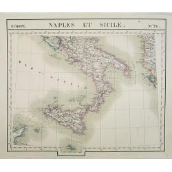
Europe. Naples et Sicile. N.26.
Detailed map including lower half of Italy with the island of Sicily.From his famous Atlas Universel . This atlas was one of the most remarkable world atlases ever produc...
Date: Brussels, 1825-1827
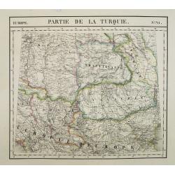
Europe. Partie de la Turquie. N°21.
Detailed map including Hungary and Romania.From his famous Atlas Universel . This atlas was one of the most remarkable world atlases ever produced, anticipating the Inter...
Date: Brussels, 1825-1827
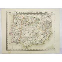
Europe. Partie de l'Espagne et Portugal. N°24.
Detailed map including Southern part of Spain and Portugal.From his famous Atlas Universel . This atlas was one of the most remarkable world atlases ever produced, antici...
Date: Brussels, 1825-1827
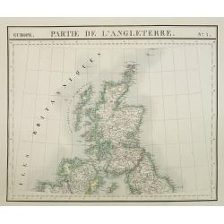
Europe. Partie de l'Angleterre. N°7.
Detailed map including Northern part of England.From his famous Atlas Universel . This atlas was one of the most remarkable world atlases ever produced, anticipating the ...
- $100 / ≈ €85
Date: Brussels, 1825-1827
![[ Spitzbergen ]](/uploads/cache/27541-250x250.jpg)
[ Spitzbergen ]
Two aquatints depicting the northern coasts of the Spitzbergen engraved by Fumagalli. From Giulio Ferrario's work Le Costume Ancien et Moderne ou Histoire du gouverneme...
Date: Milan, 1827
![[Costume plate of Grebenski Cossacks in the Caucasus]](/uploads/cache/62339-250x250.jpg)
[Costume plate of Grebenski Cossacks in the Caucasus]
Aquatint costume plate of Grebenski Cossacks in the Caucasus. Plate N° 10. From Giulio Ferrario's work Le Costume ancien et moderne ou histoire du gouvernement, de la mi...
Date: Milan, 1827
![[Costumes des Karabulaks - Caucase]](/uploads/cache/62344-250x250.jpg)
[Costumes des Karabulaks - Caucase]
Four men from the Caucasus in typical dress from the Karabulaks tribe. Plate N° 15. from Giulio Ferrario's work "Le Costume Ancien et Moderne ou Histoire du gouvern...
Date: Milan, 1827

Intérieur d'une maison groënlandaise.
This aquatint engraved plate was color printed on fine move paper of a soft aged white color, bearing the embossed seal of authenticity impressed at the time of publicati...
- $75 / ≈ €64
Date: Milan 1827
![[Calmucchi].](/uploads/cache/34988-250x250.jpg)
[Calmucchi].
Aquatint costume plate of the Kalmyk people. The name is given to the Oirats in Russia, whose ancestors migrated from Dzungaria in 1607. They created the Kalmyk Khanate i...
- $50 / ≈ €42
Date: Milan, 1827
Carte de la Russie occidentale et du Royme. de Pologne par A. Brue, Geographe du Roi . . .
Steel engraved map of Russia and Poland from his "Universal Atlas of physical geography, politics, ancient & modern."
- $150 / ≈ €127
Date: Paris, 1827
Le couvent de Nenski.
A rare lithography published by Alexandre Ivanovitch Pluchard (1777-1832) in St.-Petersburg, one of the first lithographs made in St. Petersburg. The lithographs are publ...
- $550 / ≈ €466
Date: St.-Petersburg, 1827
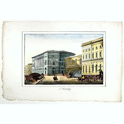
![[Untitled]. St. Petersburg.](/uploads/cache/37444-250x250.jpg)
[Untitled]. St. Petersburg.
A rare lithography published by Alexandre Ivanovitch Pluchard (1777-1832) in St.-Petersburg, one of the first lithographs made in St. Petersburg. The lithographs are publ...
- $400 / ≈ €339
Date: St.-Petersburg, 1827
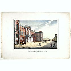
Le Palais imperial a Kamenoi Ostroff.
Fine lithography published by Alexandre Pluchart in St.-Petersburg, one of the first lithographs made in St. Petersburg. The lithographs are published in installments. Th...
- $450 / ≈ €381
Date: St.-Petersbourg, 1827
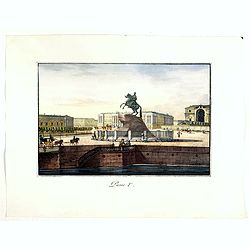
Pierre Ier.
A rare lithography published by Alexandre Ivanovitch Pluchard (1777-1832) in St.-Petersburg, one of the first lithographs made in St. Petersburg. The lithographs are publ...
- $500 / ≈ €424
Date: St.-Petersburg, 1827
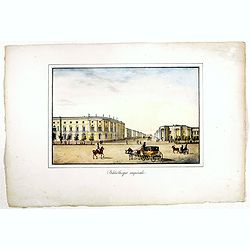
Bibliotheque imperiale.
Fine lithography published by Alexandre Ivanovitch Pluchard (1777-1832) in St.-Petersburg, one of the first lithographs made in St. Petersburg. The lithographs are publis...
- $450 / ≈ €381
Date: St.-Petersburg, 1827
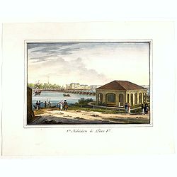
1ère habitation de Pierre 1er.
A rare lithography published by Alexandre Ivanovitch Pluchard (1777-1832) in St.-Petersburg, one of the first lithographs made in St. Petersburg. The lithographs are publ...
- $275 / ≈ €233
Date: St.-Petersburg, 1827
Le palais du Grand Duc Nicolas.
Fine and rare lithography published by Alexandre Ivanovitch Pluchard (1777-1832) in St.-Petersburg, one of the first lithographs made in St. Petersburg. The lithographs a...
- $750 / ≈ €635
Date: St.-Petersburg, 1827
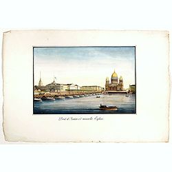
Pont d'Isaac et nouvelle Eglise.
A rare lithography published by Alexandre Pluchart in St.-Petersburg, one of the first lithographs made in St. Petersburg. The lithographs are published in installments. ...
- $500 / ≈ €424
Date: St.-Petersburg, 1827
L'Hermitage.
A rare lithography published by Alexandre Pluchart in St.Petersburg, one of the first lithographs made in St. Petersburg. The lithographs are published in installments. T...
- $500 / ≈ €424
Date: St.Petersburg, 1827
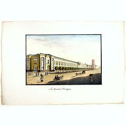
Les Grandes Boutiques.
Fine lithography published by Alexandre Ivanovitch Pluchard (1777-1832) in St.-Petersburg, one of the first lithographs made in St. Petersburg. The lithographs are publis...
- $400 / ≈ €339
Date: St.-Petersburg, 1827